
Brief Description of the Area
The Soviet Pamir is divided into three parts:
- eastern,
- central,
- western.
The central part of the Pamir is a highly elevated desert plateau, with destroyed mountains of 5000–5500 m height. The plateau is surrounded by chains of high mountains with sharply dissected relief.
The Western part of the Pamir differs sharply from the Central Pamir. Comparatively low northern slopes of the ridge with calmly flowing rivers suddenly abut against the sheer walls of the main ridge. This part of the Pamir remains a poorly studied area.
The goal of the Russian Spartak expedition was:
- more detailed study of this area,
- educational and sports high-altitude ascents,
- participation in the Union's championship for the best ascent of the season.
As a result of reconnaissance, a number of routes were identified that may be of interest to mountaineering groups.
The route to peak Zigelsa via the northern edge (see photograph route 1). Purely rock route, with very complex sections, monolithic rocks, many cracks for pitons.
Route 2. Snow-ice route along the edge of the ice drop. Dangerous exit to the edge.
Combined route 3 along the western ridge, complicated and dangerous exit to the ridge via the icefall.
Route 4 to peak K. Marx via the eastern ridge — complicated and dangerous exit to the saddle between peaks Zigelsa and K. Marx. The route is combined.
Route 5 via the northern wall to peak K. Marx. Complex rocks, average steepness — 65–75°. Many sheer sections. The wall is "shot through" with rocks.
Route 6 via the northwestern edge, combined, predominantly rock. The middle section is the most dangerous.
Route 7 — sports ice slab. The route is not complicated with sufficient snow. At the end of summer, the middle section (icefall, ice slopes) is freely passable.
Route 8 to the summit 6565 m. Mainly snow, ridge.
Route 9 combined. This is not an exhaustive list of routes of the highest category of difficulty. In addition to these routes, there are a number of peaks with an average height of 6000 m and from 3A to 5A category of difficulty.
Ascents on them can be recommended as training and acclimatization climbs. Several routes were completed by participants of our expedition.
It should be particularly noted that the weather in this area is stable and good during the summer period. During the entire period of our expedition's work, precipitation fell only three times. The area is also convenient due to relatively easy access roads and approaches:
- From Osh along the Pamir highway to Dzhalanda.
- 5–7 km before Dzhalanda, left up along the dirt road to Dzhavandos. Osh — Dzhavandos: 3 days.
- From Dzhavandos along the left tributary of Bakh-dari to the confluence of the rivers Baboy and Hitsak.
Here you can organize a base camp on a good site, with green grass and good drinking water from a well. Dzhavandos — base camp: 12–15 km. Base camp — object of ascent from the northwest: 7–9 hours.
The area is practically avalanche-free. In most cases, snow slopes are covered with huge, up to 1.5 m, nalgasporas. If there are no nalgasporas, the snow compacts horizontally during the day and only at an altitude of 6400 m and above is sometimes found crunchy snow.
Rocks in the area are located in horizontal layers. Northern slopes are more monolithic. With insulated footwear, crampons are not needed. You can walk in regular boots, but this is somewhat risky in case the group gets caught in bad weather at high altitude.
In this area, in extreme cases, you can do without down gear, with short clothing available. It should be noted that it gets sharply colder in the second half of August.
The best time for expeditions is the second half of June, July, and the first half of August.
The area can be recommended as almost transitional between the Caucasus and the Central Pamir. Here you can organize educational and sports expeditions, as well as expeditions to participate in the Union's championship.
Organizational and Tactical Plan
Organizational and tactical plan of ascent, reconnaissance, training and acclimatization exits, and supply trips.
The main task of the expedition was to train high-altitude climbers of the Russian Spartak. It was intended to give participants experience in expeditionary work, experience in reconnaissance of a new mountainous area, and experience in independent leadership of first ascents. In this regard, the expedition's work was planned and carried out as follows:
The area of peaks K. Marx and Engels from the north is poorly studied, so the routes could not be detailed in the application, and it was assumed that they would be developed on site after detailed reconnaissance.
The first reconnaissance trip was made by all participants of the expedition: Kizel V. — expedition leader, Filimonov L. — senior coach; participants: Evdokimov I. — Master of Sports, Tur V. — Master of Sports, Kazunenko V. — Master of Sports; 1st sports category Andreev V., Timoshin N., Kletsko V., Kisel S., Verbovoy V.; 2nd sports category Radinov I., Zakharenko G., Rodin I.; 3rd sports category Groshovkin A., Troyanovkin V. During the trip, the area of the western shoulder of peak K. Marx was scouted.
The second training and reconnaissance trip was undertaken by all participants of the expedition. During three days, the northwestern slopes of peaks K. Marx and Engels were scouted, and two first ascents were made to peaks up to 5000 m.

The third trip was made by three groups.
The first group: Kizel V.V., Filimonov L.V., Rodin I.V., Evdokimov I.V., Kletsko V.V., Zakharenko G.V., and Troyanov V.V. — scouted the path and reached the western shoulder of peak K. Marx. A supply dump was made on the plateau at 5900 m for the traverse and for the ascent to peak K. Marx.
The second group: Andreev V.V., Kisel S.V., Timoshin N.V. — made a training ascent to peak "Ostry" via the pass. The height of peak "Ostry" relative to the plateau 5900 m ("on the glaciers and peaks of Central Asia" by D.M. Zatulovsky, p. 252), but not less than 6300 m.
The third group: Tur V.V., Verbovoy V.V., Radimov I.V., and Kazunenko V.V. — made a first ascent to peak "Ostry" via the northwestern counterfort. Both groups left supplies for the traverse. From peak Ostry, the group first saw the path along the east-west ridge to peak K. Marx.
The third training and acclimatization trip was also organized by three groups. Groups led by Kletsko V.V. and Andreev V.V. made a traverse of three peaks from west to east. The group led by Kazunenko V.V. then made a traverse in the opposite direction.
While making the traverse, the group systematically observed the east-west ridge of peak K. Marx. Here, the final plan for the assault on peak K. Marx was outlined.
The plan for the ascent to peak K. Marx was drawn up as follows:
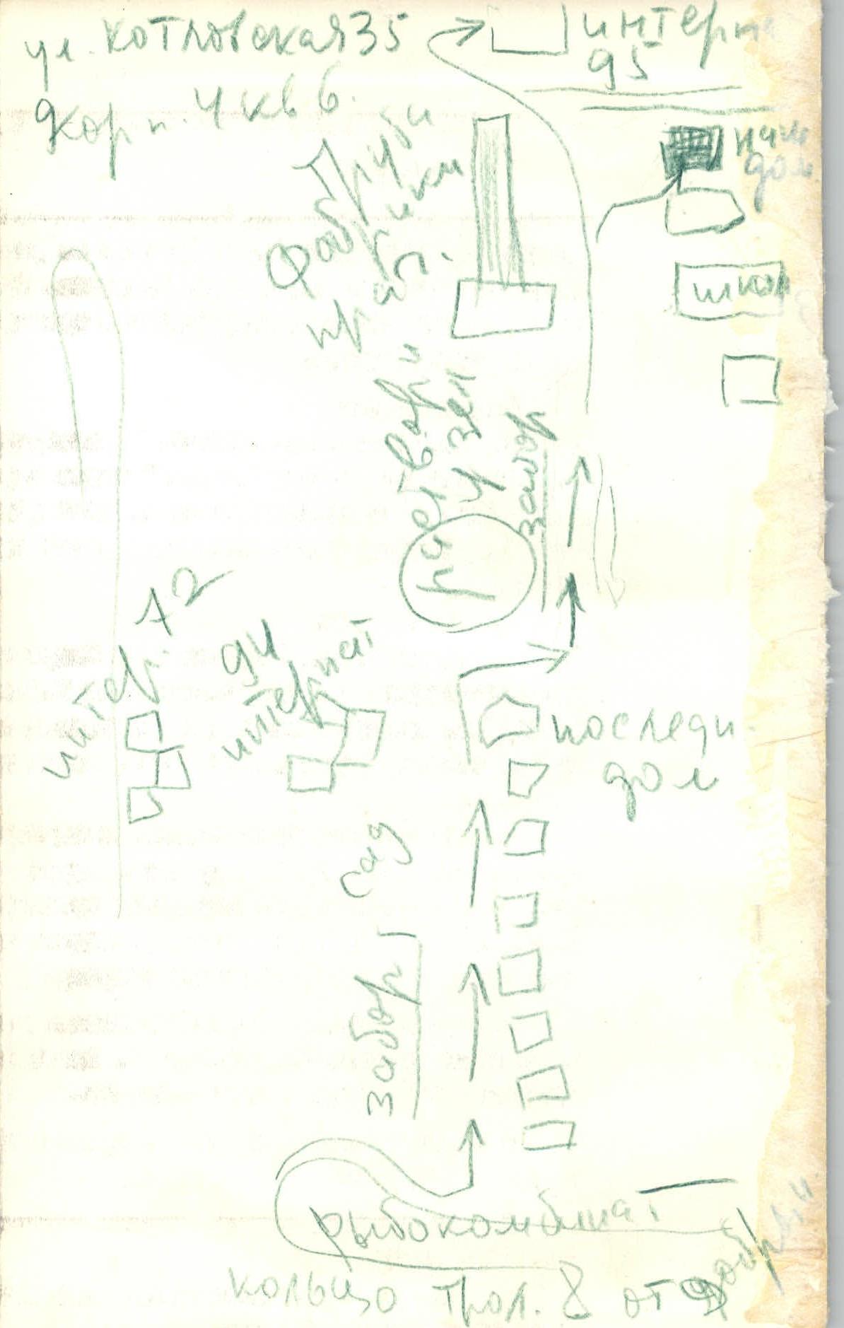
- 1st day. Base camp — moraine of the K. Marx glacier (see R0 on the diagram).
- 2nd day. Moraine — plateau of peak K. Marx — descent to the right along the East Pinchar glacier.
1st day. Base camp — moraine of the K. Marx glacier (see R0 on the diagram).
2nd day. Moraine — plateau of peak K. Marx — descent to the right along the East Pinchar glacier.
3rd day. East Pinchar glacier — east-west ridge of peak K. Marx. 4th day. Ridge — summit 6500 m. 5th day. Summit 6500 m — peak K. Marx — plateau. 6th day. Plateau — base camp.
This plan was executed without deviations during the ascent.
Composition of the Assault Group
Due to the poor knowledge of the area of peaks K. Marx and Engels from the north, as well as the fact that most of the expedition participants were participating in high-altitude ascents for the first time, the exact list of participants for each ascent was not specified in the application. Leaders and their deputies were identified, and it was assumed that the participants of each ascent would be confirmed on site after training ascents.
The participants of this ascent were approved as follows:
- Kazunenko V.D., born 1935, Ukrainian, member of the CPSU, Master of Sports of the USSR, coach, Moscow, Ostapovskoe highway, 161, apt. 26.
- Radinov I.I., born 1933, Russian, member of the Komsomol, 1st sports category, Moscow, Verkhnyaya Maslovka, 15, apt. 102.
- Verbovoy V.A., born 1936, Ukrainian, member of the Komsomol, 1st sports category, Moscow, Nagatinskoe highway, 104, apt. 17.
Group Itinerary Calendar
August 7 — the group left the base camp and along the right (orographic) bank of the Hitsak river approached the confluence of the rivers flowing from the glaciers of peaks "Ostry", "Ovalny", and "Sredny". Further up the snow slope — ascent, turn left up. A bivouac was set up on the last march.
From the moraine August 8 — ascent at 3:00. Departure at 3:40 (in the photo, on the diagram, etc.).
Within 1 hour, they approached the first icefall:
- First pitons were hammered in.
- Sometimes had to cut steps.
But now the icefall is passed, and the group reached the changeable ice bridge. This is not a difficult, but the most dangerous section of today's day. The group makes every effort to pass it as quickly as possible.
The last changeable ascent, and the group approached the second icefall.
The icefall is of medium difficulty, and it took less than 2 hours to overcome it.
Snow slope 40–50°, dense snow allows making reliable steps. The steepness of the slope gradually increases and after 50–60 m reaches 60°. The thickness of the snow does not allow for reliable insurance, so they had to cut steps. The layer of snow became thicker, the steepness of the slope decreases. Another distance of several ropes was passed in three pitches, and then they could move simultaneously.
At 12:00, the group reached the plateau at the summit of K. Marx and approached the supply dump, where there were food, hot tea, and some equipment.
Here they brewed tea, rested, filled their backpacks, and began the descent to the assault bivouac towards the Pyandzh river.
At 16:00, the group settled into a bivouac. Two people went on reconnaissance, one was busy with dinner. An hour and a half ascent up the slope of the opposite peak, and we saw our entire route.
After a long discussion of different options, the path to the summit was finally corrected here.