
For the championship of the central council of the Zenit sports society Class of high-altitude technical ascents
p. Babel (6007 m).
By the South-Western counterfort 5B cat. diff. (South-Western Pamir).
Team of the Moscow Regional Council of the Zenit Sports Society
Gorbatov B.N. — team leader (Kalinin) Ivanov V.Ya. (Kaliningrad, my) Korenev E.A. Lunov V.S. Soinov A.I. Zhukovsky, mo
8–II 1972 g.
Brief geological and geographical characteristics of the area
The mighty Pyanj river divides two mountain systems — the Pamir and the Hindu Kush — into deep valleys carved out of the rocky terrain. Flowing in a winding course, it runs along the Shahdarin Range, forming the southern boundary of the Pamir, as if encircling it from the south. The Shamdarin Range stretches for 350 km from southwest to northeast, reaching its highest heights at the peaks of Karl Marx — 6726 m and Engels — 6510 m, located near the confluence of the Vakhan-Darya river with the Pyanj. The peaks of Marx and Engels form a powerful mountain node with a fairly large glaciation area of about 140 sq. km.
One of the most significant glaciers flowing from the southern slopes of the p. Engels massif is the Kishty-Jerob glacier, which lies in a vast cirque surrounded on three sides by a palisade of peaks rising above the glacier by 1500–2500 m.
Along the left side of the glacier to the southeast of p. Engels stretches a ridge of peaks reaching heights above 6000 m. The highest point of this ridge is p. Litvy 6090 m, to the right of which, after a deep depression, stands the peak 6007 m — p. I. Babel, the target of our ascent.
Tactical plan of ascent
Guided by reconnaissance data and descriptions of the route to the summit of p. Babel, as well as consultations with comrades who had climbed this peak, a plan for the ascent was developed. The ascent was to be carried out from a base camp located as close as possible to the foot of the wall, supplied with food and equipment necessary for the climb. Such a camp was established at an altitude of 4700 m, located in a pocket of the left orographic moraine of the Kishty-Jerob glacier. A group was assigned for observation and communication, consisting of:
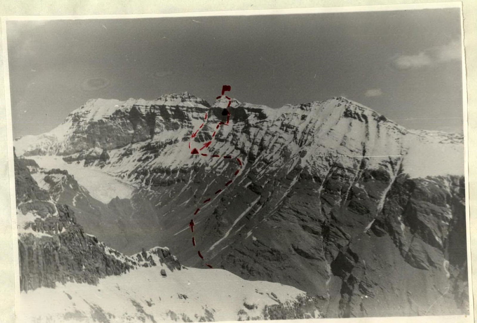 Photo 1. View of p. Babel from the "Southern peak of Moskovskaya Pravda"
- Volokonsky V. — leader
- Krivoruchenko V. — participant
- Nefedov V. — participant
- Kolomeitsev A. — participant
Additionally, there was communication with groups on the route: p. Litva (leader Penchuk V.A.) and Traverse "Moskovskaya Pravda" (leader Strikitsa N.I.).
The plan included the interaction of rope teams, with frequent changes of the lead climber. In the first group, the leader typically climbed without a backpack or with a lightened load on sections of moderate difficulty. Due to the complexity of the route and for complete safety, the entire route was traversed on a double rope, with a significant portion of it being climbed using the rope of the preceding team, i.e., the leader of the subsequent team. A detailed list of products and equipment taken on the route is provided below.
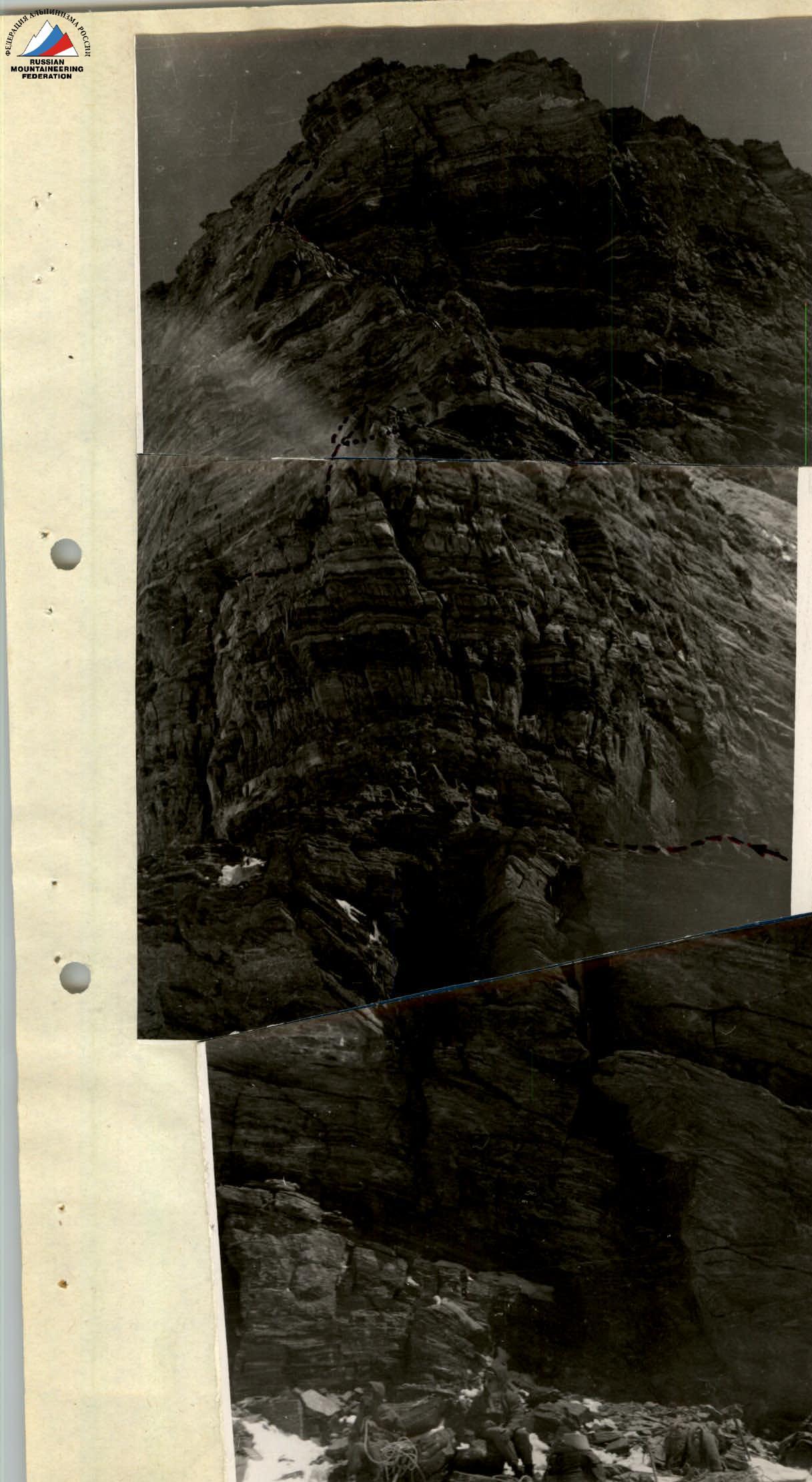 Photo 2. View from the start of the route.
Training of the group
The training period preceding the ascent focused on developing and improving endurance, strength, agility, speed, reaction, and coordination of movements. The group trained according to a preparation plan that included: in winter — cross-country skiing, in summer — cross-country running, sports games (basketball, football). During games, agility, quick reaction, and coordination of movements were honed. Throughout the training cycle, great attention was paid to gymnastic exercises and exercises with dumbbells to develop strength. Members of the group had previously climbed together in various combinations in previous years and in the same sports season. Before the ascent to p. Babel, the group members had completed a series of ascents, including ascents of 5A cat. diff. (p. Babel, p. in memory of the victims of Betnuld), 5B cat. diff. (in Chandar, in Bodkhon), which allowed the participants to acquire good acclimatization and sports form.
Equipment and provisions
The group's equipment and clothing were selected according to the nature of the route and in the necessary quantity.
In addition to the usual equipment for rock routes, the following were taken:
- duralumin bolt hammers with bolts,
- three-rung ladders,
- duralumin wedges,
- a large set of titanium pitons,
- aluminum and titanium carabiners.
For the ascent, mainly woolen and down clothing was taken, as necessary for the route. Two sleeping bags, five down jackets, three down pants, a pair of galoshes were taken for the route, in case of rapid passage of certain rock sections by the first climber.
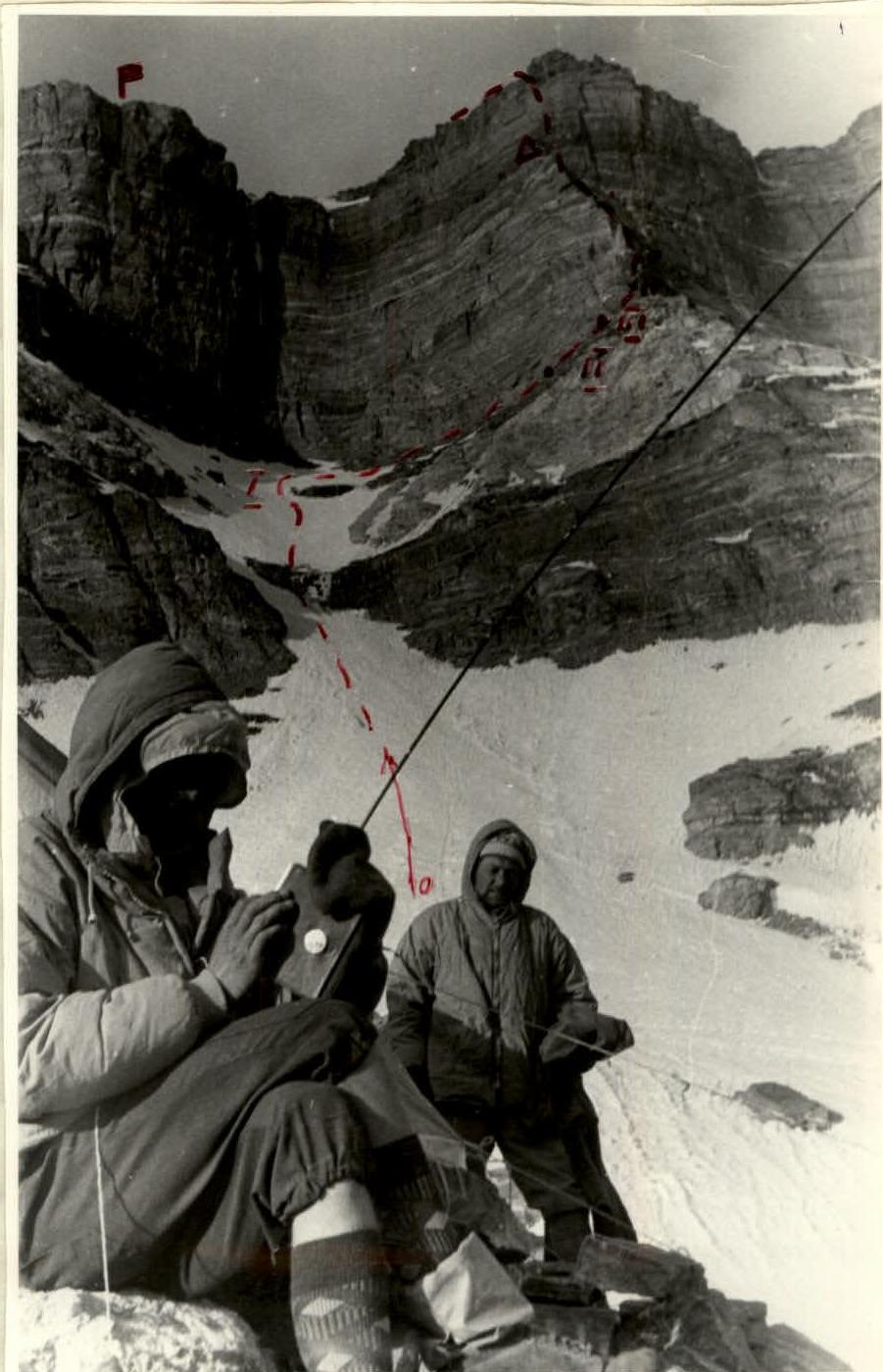 Photo 3. View from the bivouac at 4900 m.
All participants wore helmets. Food products were selected based on taste preferences, digestibility, calorie content, minimal weight, and compact packaging. A "Shmel" primus stove was used as a heat source for cooking, with a homemade kitchen. A compact radio set was used for communication.
Equipment taken on the route
| № p/p | Name | Quantity |
|---|---|---|
| 1. | Main rope (80 m each) | 2 |
| 2. | Auxiliary rope (40 m each) | 1 |
| 3. | Auxiliary rope (5 m each) | 5 |
| 4. | High-altitude tent | 1 |
| 5. | Ice axes | 4 |
| 6. | Ice hammer | 1 |
| 7. | Rock hammers | 2 |
| 8. | Belay harnesses with carabiner and self-belay loops | 5 |
| 9. | Pitons: a) titanium rock pitons | 30 |
| b) steel rock pitons | 15 | |
| c) titanium ice pitons | 6 | |
| d) duralumin wedges | 15 | |
| e) bolt pitons | 5 | |
| 10. | Bolts | 2 |
| 11. | Working carabiners | 30 |
| 12. | 3-rung ladders | 4 |
| 13. | Crampons | 2 |
| 14. | "Shmel" primus stove refueled | 1 |
| 15. | Fuel canisters (1.5 l) | 1 |
Daily route progression
1st day, August 8, 1972
Left the base camp at "4200" at 10:30. Took the path to the fork, then turned right upwards first along the path, and then along the right side of one of the couloirs up to the talus shelves. To the left along the talus shelves, sometimes transitioning into rocks of medium difficulty, to the moraine under p. Babel. The path was very physically demanding. Many loose stones that constantly slid. Overnight stay on the moraine at an altitude of 4900 m. The entire path took about 8 hours.
2nd day, August 9
Departure at 7:30, exit at 9:00. Cold, but windless, temperature around 15 °C. Moved upwards along the slope of a wide snow-ice couloir between the counterforts leading to the summit of p. Babel (on the left route 5B cat. diff., on the right 5B cat. diff.). The slope's steepness increased from 25–30° at the bottom to 45–50° at the top (R0–R1). Movement in rope teams was initially simultaneous, then alternating with belay through an ice axe, and higher up — through ice screws (2 screws), as the snow turned into ice covered with a thin layer of snow. After 3 hours of walking, the slope was passed — we emerged under a sheer smooth wall separating the counterforts mentioned above. Traversed to the right (2 ropes), section R1–R2, and we were at the base of the counterfort along which our further route lay. An excellent platform for an overnight stay. After a short rest, we continued. Ascended directly upwards along the snowy slope on the right side of the counterfort (1 rope, R2–R3), then traversed left (30 m, R3–R4, 3 rock pitons). Then ascended directly upwards along strongly destroyed sheer rocks (1 rope, R4–R5, steepness 65–85°, 6 pitons) — under a wall with so-called "petuhy" at the top. Eight meters of the wall were passed without backpacks; backpacks were pulled up (R5–R6, 3 pitons). After "petuhy", exited onto a short sharp ridge under a vertical smooth wall, along which traversed to the right (40 meters, R6–R7, 8 pitons). Then, along a vertical crevice through which water seeped, ascended directly upwards — a very difficult section (R7–R8): few holds, rocks were smooth, wet, the middle part of the section slightly overhanging. Backpacks were pulled up (8 pitons were hammered, this section was passed with the help of ladders — took 2 hours 30 minutes to overcome). Then traversed left-upwards along very strongly destroyed rocks through a vaguely expressed couloir, onto the ridge of the counterfort (R8–R9, one rope, 5 pitons, steepness 70°). After 100 m, exited onto a small platform under a vertical wall. Overnight stay. On this day, 48 pitons were hammered; height of ascent 460 m.
3rd day
First rope team's departure on the route at 8:30. Cold — air temperature −12 °C. 40-meter sheer wall (R10–R11, steepness 85–90°) was overcome directly head-on in galoshes. 8 pitons were hammered. Backpacks were pulled up. The wall ended with a small platform where it was difficult to fit three people. Took 2 hours to overcome this section. Next was a small traverse (5 m) to the left and then ascent to the right-up (R11–R12, 15 m) along stepped rocks (3 pitons) under a smooth, slightly overhanging slab with a crevice running left-upwards. The slab (R12–R13, 10 m) was traversed along the crevice — very difficult rocks. 4 pitons were hammered. Then traversed left along narrow ledges (15 m, 3 pitons) and ascended upwards (R14–R15, 5 m) onto a small platform where two people could fit and secure backpacks. All backpacks were pulled up. The complexity of this section is evident from the fact that it took all participants 3 hours to overcome. After this, followed a 5-meter wall (R15–R16), overcoming which, exited onto a wide talus shelf (R16–R17, steepness 25°, 2 pitons). Short rest and continued on, bypassing sheer walls to the right, which the ridge leading to the summit abuts. After 120 m (R17–R18) approached a snowy slope (R18–R19, steepness 35–40°, 50 m, dry, loose snow, sank up to the waist), which led onto a simple ridge. 35 minutes of simultaneous walking along the ridge — and we were at the summit. Height 6007 m, weather good.
Immediately began descent. After an hour of walking, having descended 40 meters below the saddle, hung a rope for "dulfjer" descent and laid out three more ropes for sport descent. Then 4 ropes with alternating belay, all this along a snow-ice couloir. Then descended along talus and rock shelves to the overnight stay site at "4900". Time 19:30. Next day's departure at 12:00, and at 16:00 we returned to the base camp at "4200".
The route of ascent to p. Babel (6007 m) by the Western counterfort. Height difference of the route 1107 m, including the most complex sections 200 m. Steepness of the route up to 90°.
| № | Average steepness of the section (°) | Length (m) | Character of relief | Technical difficulty | Time taken (h) | Number of rock pitons hammered | Number of ice pitons hammered | Notes |
|---|---|---|---|---|---|---|---|---|
| R0–R1 | 35 | 400 | Snow-ice couloir | Medium difficulty | 2 h 30 min | — | 2 | |
| R1–R2 | 15 | 100 | Traverse to the right along the boundary of sheer rocks and snowy slope. | Medium difficulty | 1 h 00 min | 3 | — | |
| R2–R3 | 30 | 40 | Snowy slope | Easy | 20 min | — | — | |
| R3–R4 | 10 | 30 | Traverse left along talus shelves | Medium difficulty | 50 min | 3 | — | |
| R4–R5 | 75 | 40 | Strongly destroyed, almost sheer rocks | Difficult section | 1 h 00 min | 6 | — | |
| R5–R6 | 87 | 10 | Sheer slab-like rocks | Difficult section | 30 min | 3 | — | |
| R6–R7 | 15 | 40 | Traverse right along a narrow ledge along a sheer wall | Medium difficulty | 50 min | 8 | — | |
| R7–R8 | 90 | 40 | Sheer wall, slightly overhanging in the middle, rocks smooth, wet | Very difficult section | 2 h 30 min | 8 | — | |
| R8–R9 | 70 | 40 | Strongly destroyed rocks | Difficult section | 50 min | 5 | — | |
| R9–R10 | 65 | 100 | Steep, strongly destroyed rocky ridge | Medium difficulty | 1 h 50 min | 10 | — | |
| R10–R11 | 87 | 40 | Sheer rocky wall | Difficult section | 1 h 40 min | 8 | — | |
| R11–R12 | 70 | 15 | Rocks of stepped character | Medium difficulty | 20 min | 3 | — | |
| R12–R13 | 90 | 10 | Smooth slab with a crevice | Very difficult section | 40 min | 4 | — | |
| R13–R14 | 10 | 15 | Traverse left along a narrow ledge along a sheer wall | Difficult section | 50 min | 3 | — | |
| R14–R15 | 90 | 5 | Vertical wall | Difficult section | 20 min | 2 | 1 | |
| R15–R16 | 90 | 5 | Vertical wall, destroyed rocks | Medium difficulty | 15 min | 1 | — | |
| R16–R17 | 25 | 30 | Wide talus shelf | Easy | 10 min | 2 | — | |
| R17–R18 | 30 | 120 | Talus shelves and slopes (bypassing sheer walls to the right) | Easy | 30 min | — | — | |
| R18–R19 | 35 | 50 | Snowy slope, snow dry, very loose, sank up to the waist | Easy | 1 h 20 min | — | — | |
| R19–R20 | 15 | 800 | Snow-rock ridge, exit to the summit | Easy | 1 h 40 min | — | — |
Conclusion on the route
- The route traversed by the team is logical, beautiful, and safe.
- The total length of the route is 2025 km (with a height difference of 1107 m), of which 200 m are the most complex sections. 69 rock pitons and 3 ice pitons were hammered on the route.
- Considering the technical characteristics of the route, its combined nature, and the absolute height of the summit, the team believes that the route is undoubtedly of the highest category of complexity, requiring excellent preparation of each participant, mature tactical mastery, cohesion, and camaraderie in the team for its passage.
- The team believes that deviations from the traversed route along the wall create additional difficulties.
- The presence of horizontal snow shelves dividing the rocky massif of the summit into belts and blocks creates the possibility of setting up suitable platforms on the wall for normal overnight stays.
- The physical, technical, and moral preparation of the team members fully corresponded to the chosen route.
- The planned tactical plan completely coincided with the actual one. The selected equipment, provisions, and all necessary supplies ensured the team's success in the ascent.
- The passage of the route was facilitated by a correctly chosen regimen of nutrition, as well as good weather that prevailed during the passage of the route.
- The participants of the ascent, as a result of the ascent, replenished their technical and tactical arsenal, performing a large amount of labor-intensive and technically complex work at an altitude of about 6000 m.
- The initial report on the ascent was heard by the coaching council of the Pamir expedition: MOS DSO "Zenit".
Team leader Team coach Master of Sports (IOPREATOV E.N.) (PENCHUK V.L.)