
Report on Ascent to Pik Suloeva (5816 m) via the West Ridge
First ascent, approximately 4A category of difficulty (Protocol No. 313, 3A).
Leader – Zaseckij V. G.
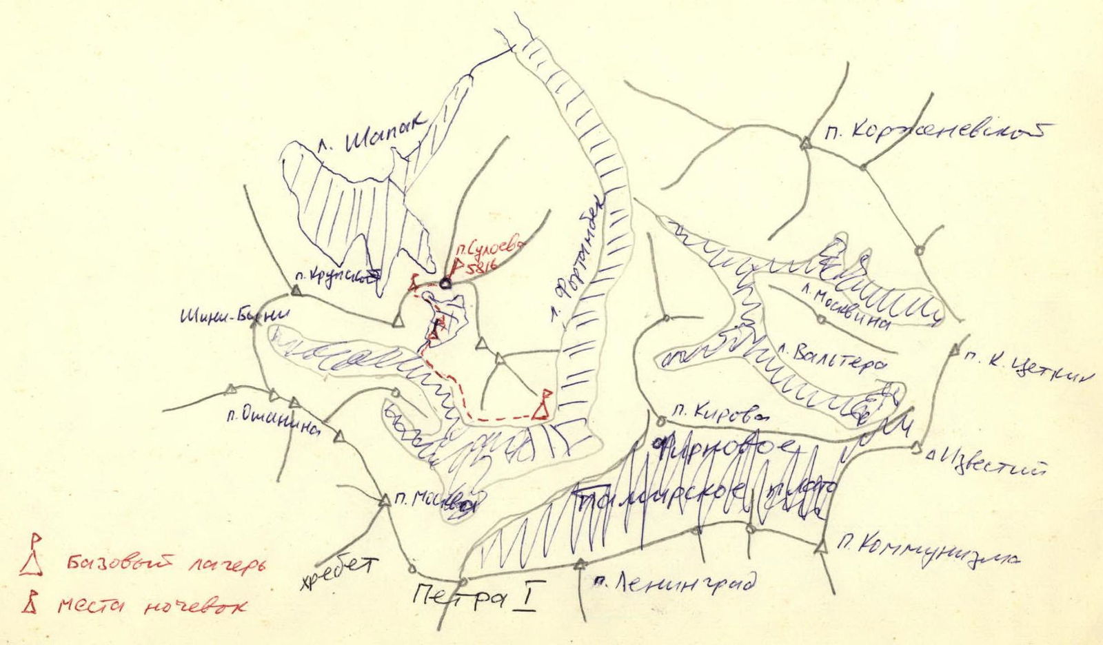
Fortambek Glacier Basin
 The summit of Pik Suloeva (5816 m) is located in the eastern branch of the northern spur of the Peter I Range, branching off from Pik Moskva. The ascent to the summit was undertaken for acclimatization purposes, and therefore it was decided to climb the peak via the easiest route, which, after studying images of the summit from different sides, was assumed to lead to the summit from the Western cirque. The ascent was planned and prepared in Moscow.
On July 17, 1969, at 6:00, the group consisting of Zaseckij, Grebenschikov, Bozhukov, Nadbah, Nevvorotin, and Poroshin departed from the base camp located in a pocket of the left-bank moraine of the Fortambek Glacier (see diagram). 3 hours of walking along the moraine with a marked path, and another 1 hour ascent along the lateral moraine of the unnamed glacier, and then along the glacier itself – exit into the cirque formed by the southern and western ridges of the summit. Here, on the median moraine, they prepared a site and set up a tent. After resting and having lunch at 16:00, when the daytime heat had subsided, Bozhukov, Grebenschikov, and Nadbah went on a reconnaissance sortie to the upper reaches of the "Novator" glacier, as the unnamed glacier was decided to be named. After 2 hours, they returned and reported that:
- There is, apparently, a good exit to the West Ridge beyond the glacier's bend;
- There is also an interesting path to the summit along the counterfort of the West Wall.
On July 18, 1953, at 6:30, the group departed from their overnight stay. First, along the middle part of the glacier, then, bypassing crevasses on the left, they ascend to the second step of the glacier and further along the middle part of the glacier – to the third step.
The steps are approximately equal in height to each other – about 180–200 m, with a steepness of 40–45° between them. The second and third steps are closed.
Further, the path to the ridge saddle goes along a snow slope with ascents of average steepness of 30–35°. After 4.5 hours, they reach the ridge at an altitude of 5100–5200 m, having gained 500–600 m in altitude from their overnight stay. They set up a tent and prepare lunch.
From here, the counterfort is very well visible. It is here that the decision is made:
- Nadbah's group (leader), Grebenschikov, and Nevvorotin will make an attempt to climb the summit via the counterfort tomorrow;
- The rest, led by Zaseckij, will ascend to the summit along the West Ridge and properly inspect the upper part of the counterfort.
At 16:00, they depart. The path along the ridge goes mainly along the snow, but often encounters rocky outcrops, which are overcome simultaneously. The ridge – with ascents steepness up to 35° and length up to 60 m, its average steepness – 20°.
After 2 hours, they approach the pre-summit ascent – 200–250 m, with a steepness of 35–40°. The path along the ridge is blocked by a rocky wall "Zom", with a steepness of 60–65°, with many loose rocks.
They decide to bypass it on the left along the ice slope, covered with a 10-centimeter layer of snow. They have to cut steps in some places, with protection provided by protruding rocks and an ice axe.
Further along the snow-ice ridge – exit under the summit and then ascent along rocks 10 m to the summit.
They build a cairn and at 19:30 write a note on the summit (5816 m), naming it after Valentin Suloev – their comrade who perished in 1968 in this region of Pamir.
After photographing from the summit, they begin their descent. During the descent, they bypass the wall using a sport descent. Along the ascent route, they descend to the tents by 20:30, where their comrades await them with hot tea.
On July 19, at 7:00, Nadbah's group departs and descends to the start of their route. They, however, depart at 9:30 and descend to the second step of the glacier in 40 minutes, where they pitch a tent under a tarp on a cluster of rocks and conduct visual observation of Nadbah's group, not forgetting to communicate with them via radio every 2–3 hours. By 15:00, it becomes clear that the group will be able to complete the route and descend to them. At 21:00, the tired but satisfied climbers descend.
July 20. Departure at 7:00, and after 2 hours, they reach the base camp.
Route Conclusion
The route was completed in good meteorological conditions. The success of the ascent was facilitated by thorough preparation back in Moscow, year-round training, as well as an excellent selection of equipment and supplies.
Participants were equipped with:
- full down and woolen gear;
- a lightweight high-altitude tent;
- insulated footwear.
The route, according to V. Bozhukov, is considered a good route of 4A category of difficulty.
Table of Main Route Sections
- Snow slope, 30–35°, 600 m.
- Snow slope with rocky outcrops, 20°, average steepness, 800 m.
- Ice slope, 35–40°, 40 m.
- Snow-ice slope, 35–40°, 200–250 m.
Comments
Sign in to leave a comment