
Report
on the first ascent to Peak 7490 m (Peak N. Ostrovsky) via the West Ridge, made by the combined team of the Ukrainian SSR Sports Committee, led by S.I. Bershov, consisting of:
- G.I. Vasilenko
- V.G. Boyko
- V.P. Gordeev
- S.K. Sentsov
- V. Rekoslavsky
- P.F. Slavinsky
- A.N. Tolstousov
Between June 8 and June 13, 1979.
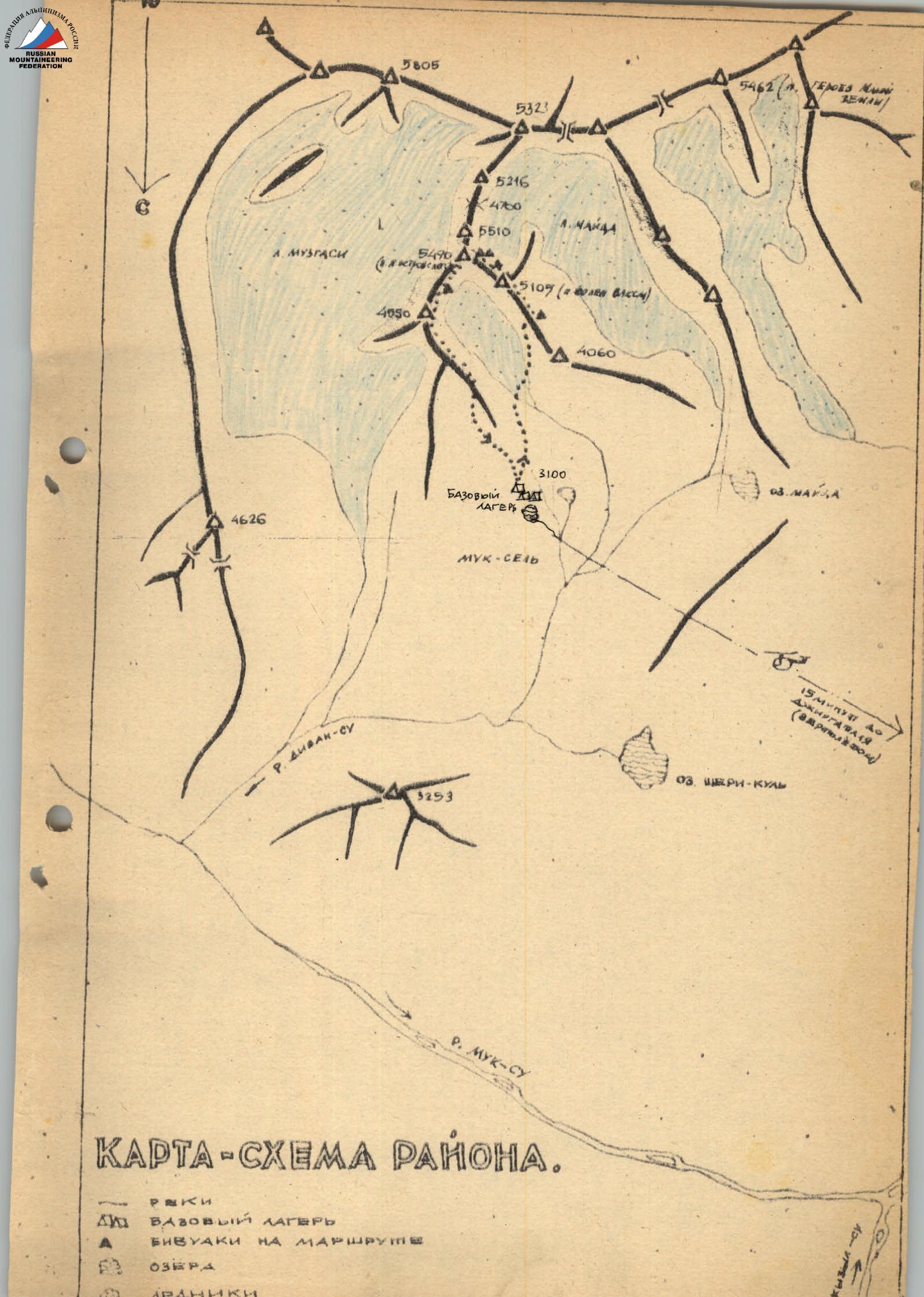
 Map of the area
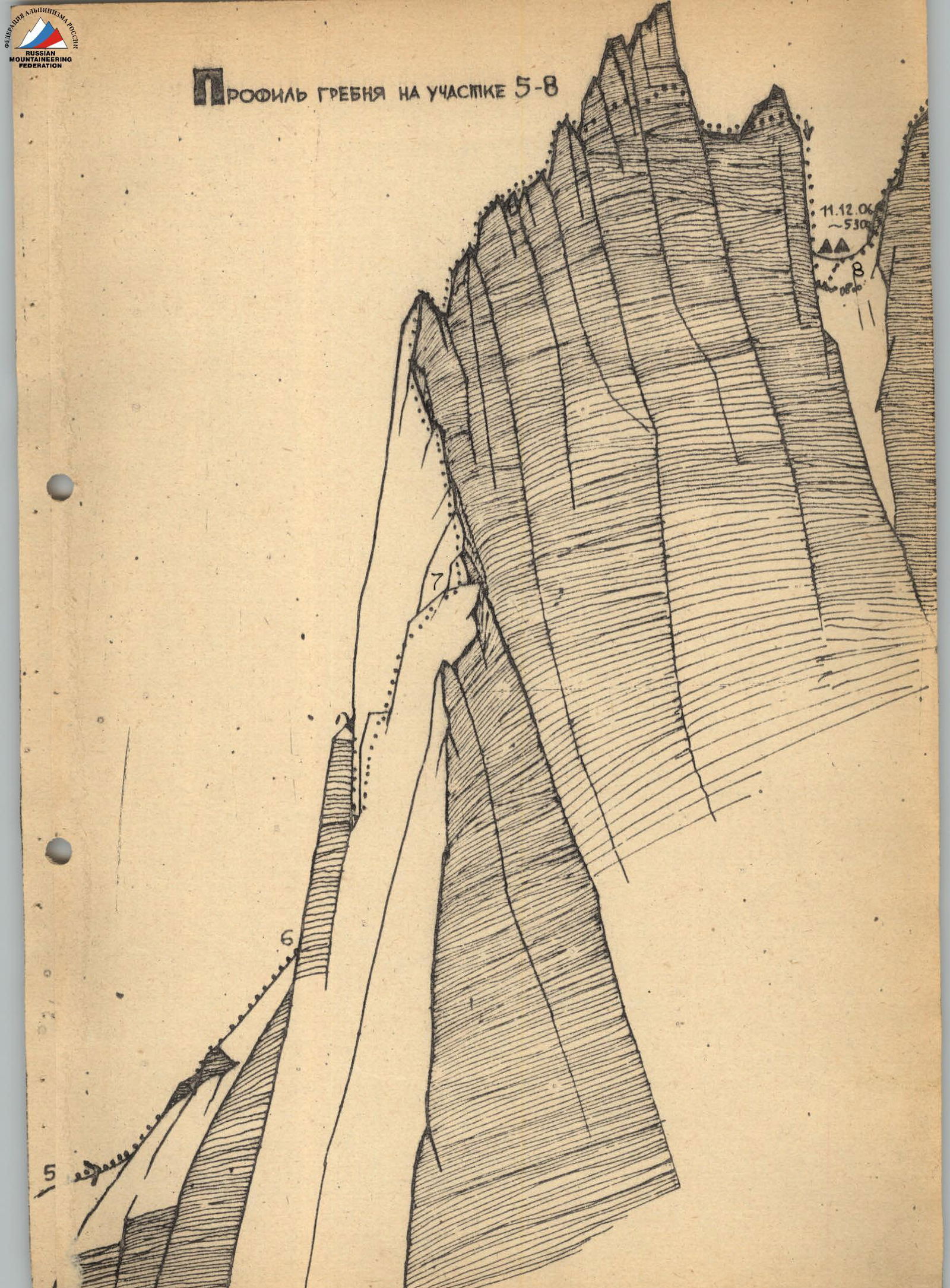
 Ridge profile for section R5–R8
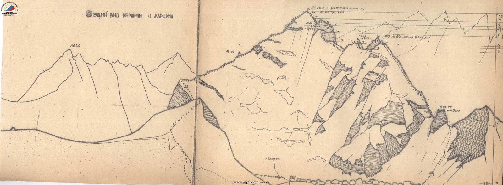
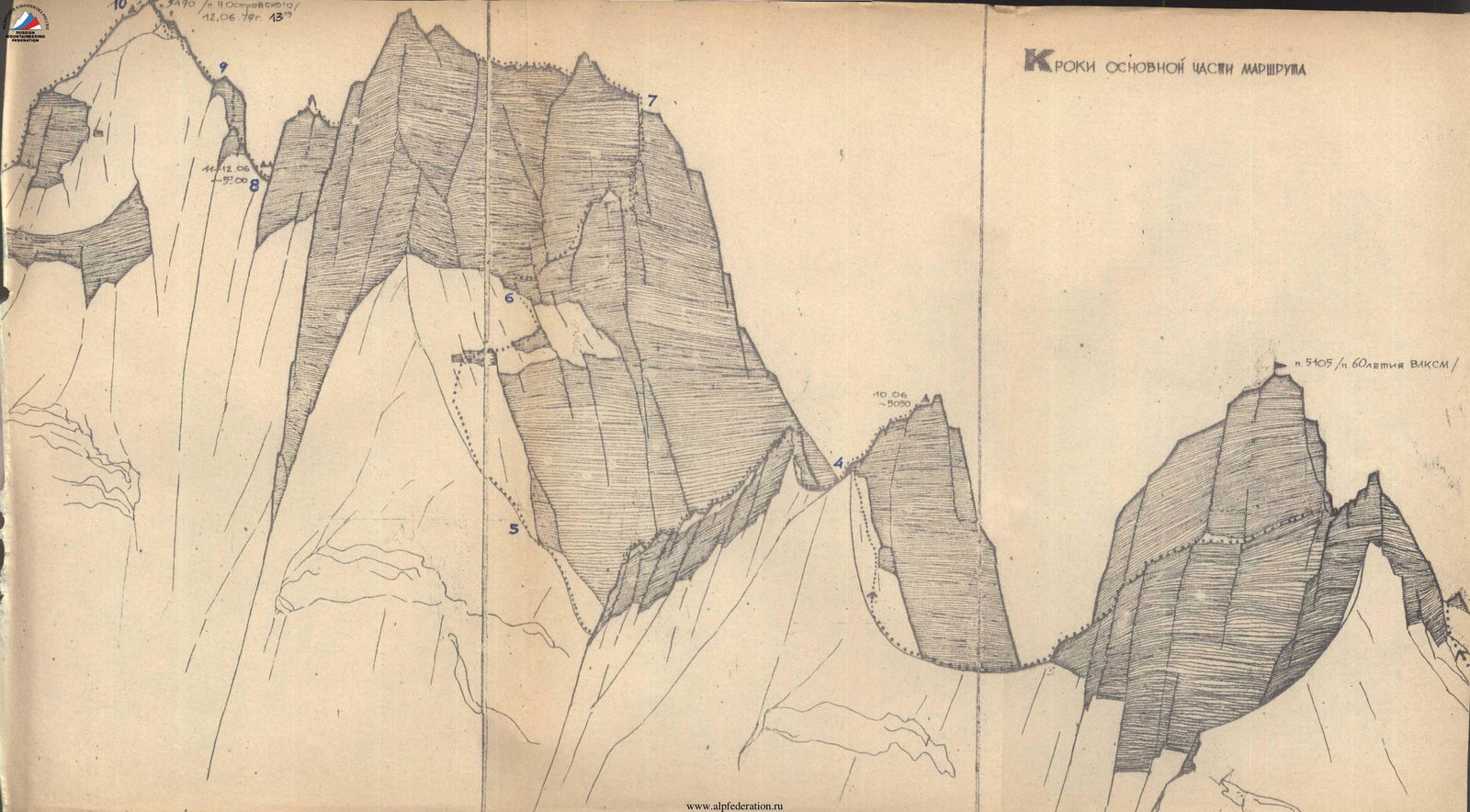 General view of the summit and route
Main Route Characteristics Table
| Date | Section Designation | Length, m | Steepness, ° | Terrain Characteristics | Difficulty | Condition | Weather Conditions | Rock Pitons | Ice Pitons | Notes |
|---|---|---|---|---|---|---|---|---|---|---|
| 8.06 | R0–R1 | 1000 | 43 | Snow couloir | 2 | Deep snow | Good | Simultaneous | – | Departure at 14:00. Halt at 17:00 |
| 9.06 | R1–R2 | 800 | 53 | Snow-ice slope | 45 | Firm snow | Good | Simultaneous | – | Departure at 8:00 |
| R2–R3 | 300 | 60 | Rocky ridge, gendarme | 5A | Loose rocks | Good | 6 | – | Halt at 18:00. 10 hrs. | |
| R3–R4 | 120 | 60 | Ice slope | 5B | Frozen ice | Good | 8 | 10 | ||
| 10.06 | R4–R5 | 800 | 50 | Combined ridge | 45 | Fresh snow on ridge | Good | Via outcrops, rock face | – | Departure at 8:00. Halt at 18:00. 10 hrs. |
| R5–R6 | 100 | 50 | Flow ice, rocky outcrops | 5B | Frozen ice | Good | 18 | 4 | ||
| R6–R7 | 120 | 70–80 | Rocky bastion | 5B | Loose rocks | Good | 41 | – | ||
| R7–R8 | 200 | 45 | Rocky ridge | 5A | Sharp ridge | Snow | 15 | – | ||
| 11.06 | Bad weather (strong wind, snow) - bivouac | |||||||||
| 12.06 | R8–R9 | 160 | 60 | Snow-ice ridge with rocks | 5B | Loose, frozen rocks | Good | 20 | 4 | Departure at 8:00. Summit at 13:15 |
| R9–R10 | 300 | 45 | Loose ridge | 2B | Loose rocks | Good | Simultaneous | – | ||
| 13.06 | Descent via North Ridge to base camp | |||||||||
| Elevation Gain | 2190 m | 108 | 18 | 28 travel hours | ||||||
| Route Length | 3900 m | |||||||||
| Travel Hours | 28 hrs |
Brief Explanation of the Main Route Characteristics Table
On June 8, 1979, the team approached the base of the West Ridge of Peak 5490 from the base camp by the lake.
Section R1. Ascent up the snowy couloir to the saddle of the West Ridge. Bypassing the rocky "Gendarme" on the southern side via loose rocks. The snow in the couloir was deep and loose. Frequent changes of the lead climber. Overnight stay on the saddle.
June 9. Departure at 8:00 AM.
Section R2. Initially, the snow was frozen, then it became loose and powdery. Frequent change of the lead climber. Covered 800 m until reaching the "Gendarme". The "Gendarme" was bypassed on the right.
Section R3. Rocky ridge of Peak 60 let VLKSM and bypassing it on the left. The rocks were loose.
Section R4. Ice slope. Initially, steep snow leading to rocks, and then 120 m of steep winter ice. Climbed with ice axe and ice hammer on crampons. Overnight stay on the "Gendarme" summit after some construction work.
June 10. Departure at 8:00 AM.
Section R5. Movement along the rocky-snowy ridge towards Peak 5490. Descent to a col before ascending to a rocky bastion.
Section R6. Along the loose ridge, reached an ice slope with embedded rocks, which led to a rocky bastion.
Section R7. Rocky bastion. Initially, along a snow-ice ledge into an inner corner (40 m). From the inner corner, moved right and upwards to a snow ledge (40 m). Then, up steep loose rocks with limited crack space for piton placement, exited onto the ridge of the bastion (40 m).
Section R8. Along the ridge, 200 m towards the summit. The ridge was very sharp and loose. In some places, climbers moved sitting on the ridge. After the ridge ended, descended 40 m to a col (Dülfer). Here, they set up an overnight camp on the snow.
June 11 was spent in tents due to bad weather. Snowfall lasted for 24 hours.
June 12. Departure at 8:00 AM.
Section R9. Initially, along the snowy ridge, and then descended to a col (80 m). Then, another 80 m along a heavily damaged ridge, partly icy, and reached the pre-summit shoulder.
Section R10. Movement along the damaged ridge to the summit.
Descent was made via the North-East ridge.
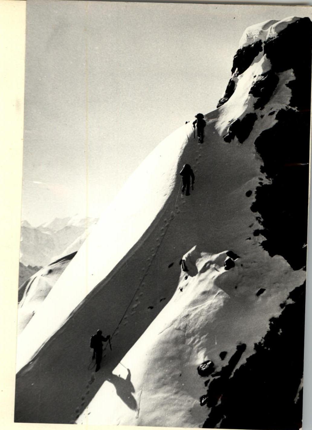 Combined ridge (rocks, snow, ice) - section R4–R5.