
10
Ascent Passport
- Category of first ascents.
- Region: Eastern Pamir, Muzkol Ridge.
- Peak CHOTAGAY (6133 m) via the S-3 counterfort of the wall, rock route.
- Proposed category of complexity — 5B, first ascent.
- Height difference — 1300 m, length — 1680 m.
The average steepness of the main part of the route — 62° (5050–6000 m). Length of sections with 5–6 category of difficulty — 710 m, ~45–50°.
- Pitons driven:
| Rock | Nuts | Ice |
|---|---|---|
| 38 | 75 | 1 |
- Number of climbing hours — 34.5.
- 2 overnight stays, both in tents on scree ledges.
- Team Leader: Glushkov Alexander Semenovich — Master of Sports
Team members: Zhak Viktor Vladimirovich — Master of Sports, Ivanov Nikolai Rufovich — Master of Sports, Aivazov Mikhail Borisovich — Master of Sports, Ovsyannikov Dmitry Alexandrovich — Master of Sports, Zhukov Alexander Borisovich — Candidate Master of Sports. 10. Coach: Dzhibranv Yuri Georgievich, Master of Sports of the USSR. 11. Departure to the route — July 10, 1986.
Reached the summit — July 12. Return — July 12, 1986. 12. Organization: Sports Club of the Army, Leningrad Military District.
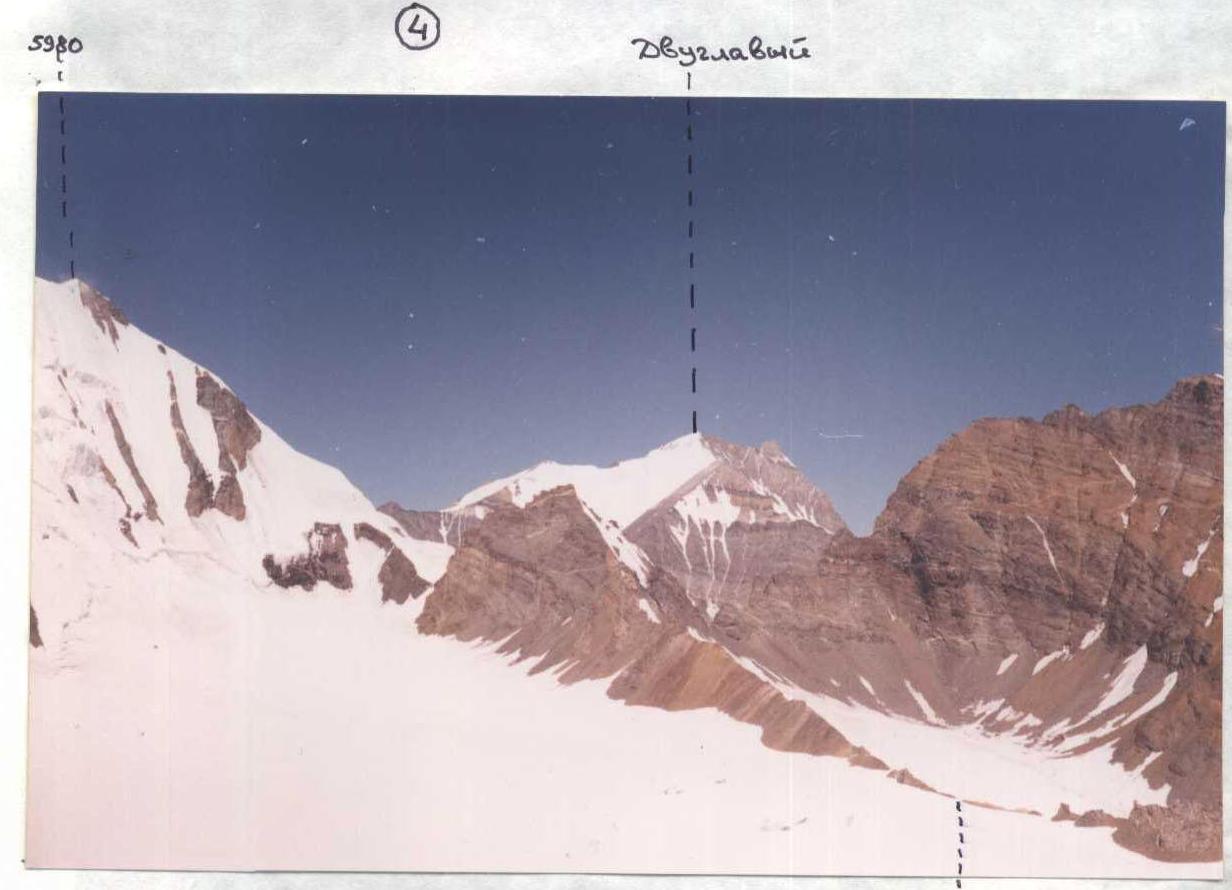
Panorama of the area (3)

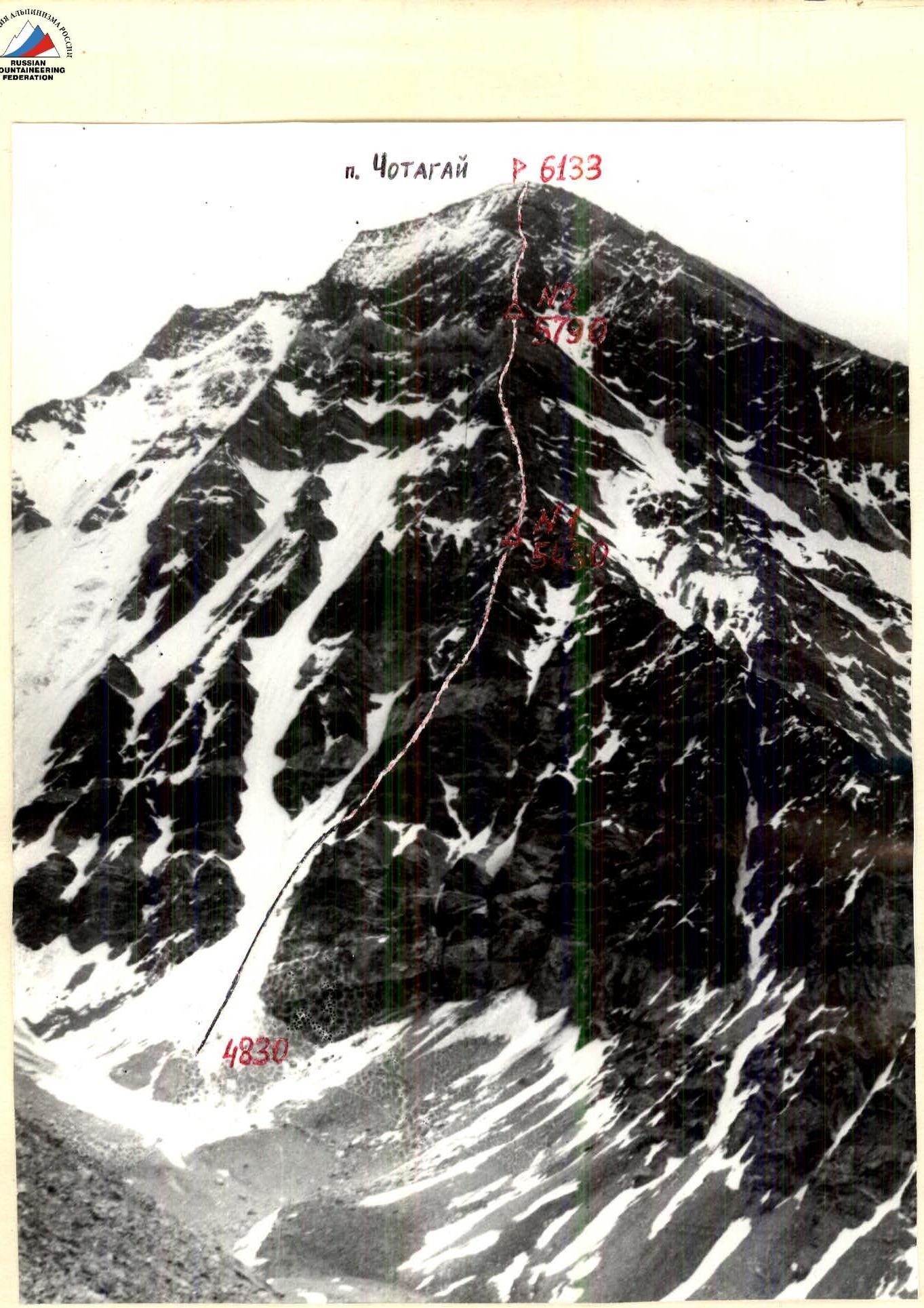
GENERAL PHOTO OF THE SUMMIT Taken on July 8, 1986. LENS "INDUSTAR-50". DISTANCE ~2 km. HEIGHT 4800. SHOOTING POINT ON THE AREA SCHEME №1.
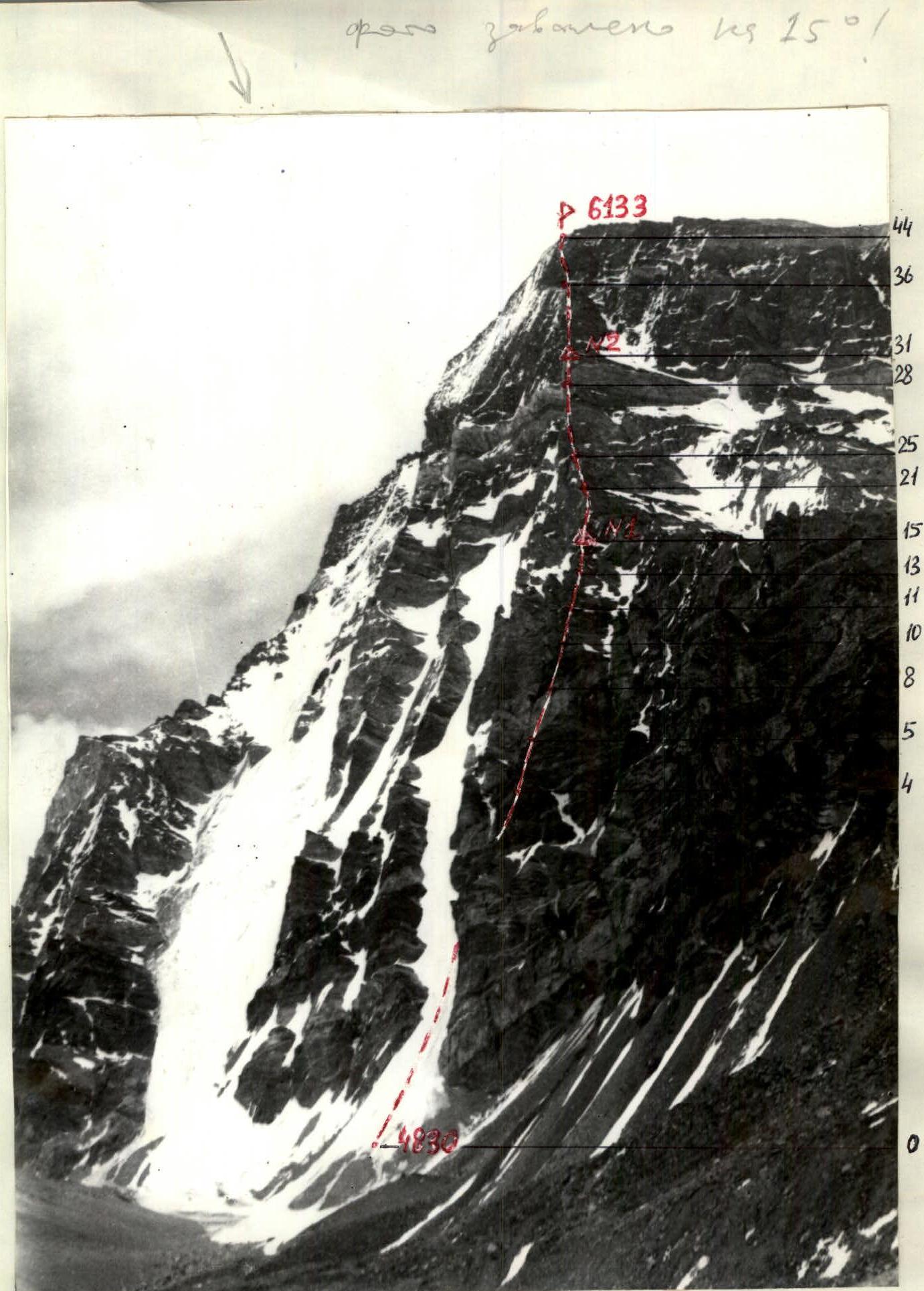
PROFILE OF THE ROUTE FROM THE RIGHT
Taken on July 8, 1986. LENS "INDUSTAR-50". DISTANCE ~2 km. HEIGHT 4800. SHOOTING POINT №2.
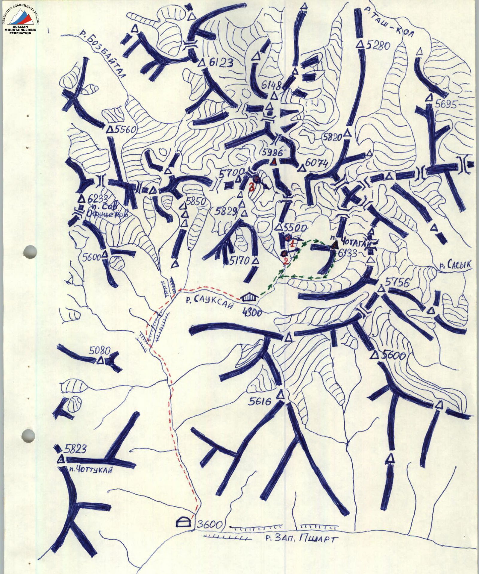
MAP OF THE MUZKOL RIDGE NODE Scale 1:100,000
- Lower base camp
- Upper base camp
- Shooting points
- Ascent and descent route
Brief Overview of the Ascent Area
The object of the ascent — peak Chotagay (6133 m) — is located in the Muzkol Ridge (Eastern Pamir) and is one of the highest points in the area. Overall, the Muzkol Ridge area is practically undeveloped by climbers. The expedition of the Sports Club of the Army, Leningrad Military District, was the first climbing event in this area.
The area is characterized by:
- inaccessibility,
- remoteness from transportation arteries,
- harsh climatic conditions — sharply continental climate, low humidity.
In terms of climbing, the area is very promising and is characterized by a large number of peaks with heights of 5600–6200 m, to which rock and combined routes of category 2B to 6B can be laid.
Almost all routes in the area start at heights of 4800–5100 m, which is a specificity of the area and creates certain difficulties during ascent, as all technical difficulties are located at heights of 5000–6000 m. This requires participants to have:
- a high level of physical and technical preparation;
- good acclimatization.
Access to the ascent area is as follows: from Osh city by car to Murghab city, then by car along the Eastern Pshart valley through Ak-Tash pass (4200 m) to the Western Pshart valley (total about 40 km).
Then:
- On foot along the trail to the confluence of the Western Pshart and Sauk-Sai rivers. The trail is difficult, and at the end of the path, it passes through a canyon about 5 km long, where 9 to 15 river crossings are required.
- From the confluence upstream to the Sauk-Sai glacier, where the assault camp was set up.
For reference:
- Transportation of expedition cargo from the camp under Ak-Tash pass to the confluence of the Western Pshart and Sauk-Sai rivers took 6 days;
- the path from the base camp to the assault camp took 7 hours;
- the capabilities of the local population regarding pack transport are very limited.
Tactical Actions of the Team
The tactical actions of the team during the ascent were determined by the planned tactical plan, the nature of the terrain, and weather conditions. The main feature of the terrain is that despite a wide variety of rocks, they are all characterized by extremely high fragmentation along almost the entire route.
In the lower part of the route, limestones and sandstones predominate, giving the rocks a characteristic red-brown color. Movement and organization of belays are complicated here by the fragility of the rocks, covered with a crumbling crust, and the small number of cracks.
In the middle part of the route, rocks consisting of granite blocks predominate, weakly held together, but sometimes forming cornices. In the upper part, the main difficulty is presented by a steep "black" belt, composed mainly of schist, which is also characterized by fragility and lack of cracks.
These features of the terrain require the leader to:
- exercise special caution during movement;
- carefully choose belay points;
- pay utmost attention and be meticulous when moving all team members.
To ensure maximum safety, movement was conducted only on ropes with a double rope for all participants, and belay points were organized in places protected from possible rockfall. The pace of movement was regulated so that the team did not stretch more than two rope lengths.
According to the tactical plan, the team started the route on July 10 at 9:00. On the section R0–R1, Aivazov worked first; when the terrain changed to rock, a change was made, and sections R1–R17 were first passed by the rope team Glushkov – Zhak. At 20:00, the main part of the team began to organize a bivouac, and the pair continued further processing of the route until 21:00. By 21:30, the entire team had gathered at the bivouac.
On July 11, at 7:30, the rope team Ivanov – Ovsyannikov began working. The work was completed by 21:00.
Both overnight stays were organized according to the tactical plan.
The duration of work on the route was determined by:
- the condition of the participants,
- their physical and technical preparation,
- the regime of wall illumination (until 22:00).
On the night of July 12, a heavy snowfall began, and by morning, the rocks were covered with a layer of snow 10–15 cm thick, which greatly complicated movement, as it was necessary to clear snow in search of cracks and holds.
On that day:
- Movement started at 9:00
- The rope team Aivazov – Zhukov worked ahead
- By 11:00, all participants were at the summit
- Descent to the upper base camp along the southern ridge took 3 hours 30 minutes.
The tactical plan was fully executed. There were no radio communication gaps.
| Section № | Rock Pitons | Nuts | Ice Pitons | Category | Length, m | Steepness, ° |
|---|---|---|---|---|---|---|
| 10 | – | – | – | 3 | 40 | 30 |
| 9 | 2 | 4 | – | 5 | 50 | 70 |
| 8 | – | – | – | 3 | 10 | 40 |
| 7 | – | 2 | – | 4 | 15 | 60 |
| 6 | – | – | – | 3 | 20 | 35 |
| 5 | 2 | 6 | – | 5 | 60 | 65 |
| 4 | – | 1 | – | 3 | 30 | 60 |
| 3 | 1 | 2 | – | 6 | 10 | 95 |
| 2 | – | 3 | – | 5 | 35 | 70 |
| R1 | – | – | 1 | 3 | 280 | 50 |
| Section № | Rock Pitons | Nuts | Ice Pitons | Category | Length, m | Steepness, ° |
|---|---|---|---|---|---|---|
| 29 | 1 | 2 | – | 5 | 25 | 70 |
| 28 | – | – | – | 3 | 15 | 45 |
| 27 | 5 | 6 | – | 5 | 80 | 70 |
| 26 | – | 1 | – | 3 | 40 | 40 |
| 25 | 2 | 2 | – | 5 | 25 | 80 |
| 24 | – | – | – | 3 | 30 | 40 |
| 23 | 2 | 3 | – | 5 | 30 | 80 |
| 22 | – | – | – | 2 | 25 | 25 |
| 21 | 3 | 5 | – | 5 | 35 | 80 |
| 20 | – | – | – | 3 | 40 | 30 |
| 19 | – | 1 | – | 5 | 10 | 80 |
| 18 | 1 | – | – | 2 | 20 | 25 |
| 17 | – | 2 | – | 5 | 30 | 75 |
| 16 | 2 | 1 | – | 4 | 40 | 20 |
| 15 | 1 | 2 | – | 5 | 20 | 75 |
| 14 | – | – | – | 2 | 10 | 30 |
| 13 | – | 1 | – | 5 | 20 | 70 |
| 12 | – | 4 | – | 4 | 80 | 70 |
Climbing hours — 12.
| Section № | Rock Pitons | Nuts | Ice Pitons | Category | Length, m | Steepness, ° |
|---|---|---|---|---|---|---|
| 45 | 1 | 1 | – | 3 | 40 | 10 |
| 44 | 2 | 3 | – | 4 | 60 | 50 |
| 43 | – | – | – | 3 | 40 | 30 |
| 42 | 1 | 1 | – | 5 | 10 | 70 |
| 41 | – | – | – | 2 | 15 | 20 |
| 40 | 1 | 1 | – | 5 | 10 | 75 |
| 39 | – | – | – | 3 | 40 | 35 |
| 38 | 1 | 1 | – | 6 | 10 | 85 |
| 37 | – | – | – | 3 | 20 | 30 |
| 36 | 2 | 3 | – | 5 | 40 | 70 |
| 35 | – | – | – | 2 | 10 | 20 |
| 34 | 1 | 3 | – | 5 | 30 | 70 |
| 33 | 2 | 4 | – | 6 | 40 | 90 |
| 32 | 2 | 5 | – | 5 | 80 | 70 |
| 31 | – | – | – | 2 | 30 | 25 |
| 30 | 5 | 6 | – | 6 | 60 | 90 |
Climbing hours — 9 (sections R11–R21). Climbing hours — 13.5 (sections R21–R29).
Description of the Route by Sections
R0–R1: Steep ice in the upper part of the couloir. Climbing on front points of crampons.
R2–R3: Cornice consisting of "live" blocks. The leader needs to pay utmost attention during passage.
R4–R5: Destroyed wall, icy in the upper part.
R8–R9: Destroyed limestone wall. Very few cracks.
R13–R14: Destroyed limestone wall covered with a crumbling crust.
R15–R16: Bypassing a sentinel to the left along slabs covered with flowstone ice.
R16–R17: Exit to the ridge along a wall with few cracks.
R18–R19: Very destroyed sandstone wall.
R20–R21, R22–R23, R24–R25: Direct passage of sentinels. Destroyed walls consisting of blocks.
R28–R29, R29–R30: Bypassing a sentinel to the left along slabs with few cracks, then along a wall with cornices. Snow cornice at the exit to the ridge.
R31–R32, R32–R33: Overcoming a sentinel first to the right along a destroyed wall, then along the left wall with a cornice.
R37–R38: Direct passage of a sentinel along a smooth wall with few holds.
Note: after the snowfall, rocks on sections R31–R45 were covered with a layer of snow 10–15 cm thick. It was necessary to clear snow in search of holds and cracks.
Comments
Sign in to leave a comment