International Mountaineering Club 2003-2004
Reports on First Ascents
in the Saroz Lake area, Pamir Mountains
on the peaks of the Rushan and Muzkol ranges
International Mountaineering Club
Address: Moscow, Luzhnetskaya Embankment, 8, Russian Olympic Committee, office 330 Phone/Fax (095) 725–45–28, e-mail: mak@roc.ru, http://www.clubalp.ru↗
Club President
Valery Vladimirovich Kuzin — First Vice-President of the Russian Olympic Committee
Head Coach
Yuri Viktorovich Baykovsky — Honored Coach of the Republic of Tajikistan
Table of Contents
I. Table of Peaks (3 pages)
II. Overview of the Saroz Lake Area
- a. Map of the Republic of Tajikistan ... 4 pages
- b. Description of the area ... 5 pages
- c. Road to Saroz Lake ... 7 pages
- d. Map of Saroz Lake ... 8 pages
III. Reports on Ascents to Peaks in the "Birombnd" Area
-
a. Map and description of the area ... 10 pages
- "Olimp-2004" (5674 m) ... 11 pages
- "Poytakt" (5601 m) ... 20 pages
- "International Mountaineering Club" (5337 m) ... 26 pages
- "Obzornaya" (4424 m) ... 35 pages
IV. Reports on Ascents to Peaks in the "Shadau" Area
-
a. Map and description of the area ... 42 pages
- "10 лет МЧС" (5250 m) ... 45 pages
- "USOY" (5120 m) ... 53 pages
- "Spasatelei" (5050 m) ... 60 pages
- "Gornykh gidov" (5080 m) ... 69 pages
| Area | Peak Name | Height | Location | Route Name | Route Difficulty |
|---|---|---|---|---|---|
| Birombnd | "Olimp-2004" | 5674 m | N 38°17.093′ E 072°42.198′ | via Western Ridge | 3A cat. diff |
| "Poytakt" (Capital) | 5601 m | N 38°17.150′ E 072°40.550′ | via Southern Ridge | 2A cat. diff | |
| "International Mountaineering Club" | 5337 m | N 38°16.450′ E 072°40.960′ | via internal angle of Eastern Wall | 4B cat. diff | |
| "Obzornaya" | 4424 m | N 38°12.650′ E 072°42.450′ | via Southeastern Ridge | 1B cat. diff | |
| Shadau | "10 лет МЧС" | 5250 m | N 38°11.910′ E 072°30.001′ | via Eastern Ridge | 2B cat. diff |
| "USOY" | 5120 m | N 38°11.820′ E 072°30.950′ | via Eastern Ridge | 2A cat. diff | |
| "Gornykh gidov" | 5080 m | N 38°10.720′ E 072°33.350′ | from North | 2B cat. diff | |
| "Spasatelei" (Nachotdikhanda) | 5050 m | N 38°11.020′ E 072°31.250′ | via Northern counterfort | 4B cat. diff |
Map of the Republic of Tajikistan
(Route from Dushanbe to Gorno-Badakhshan Autonomous Region, to the Saroz Lake area)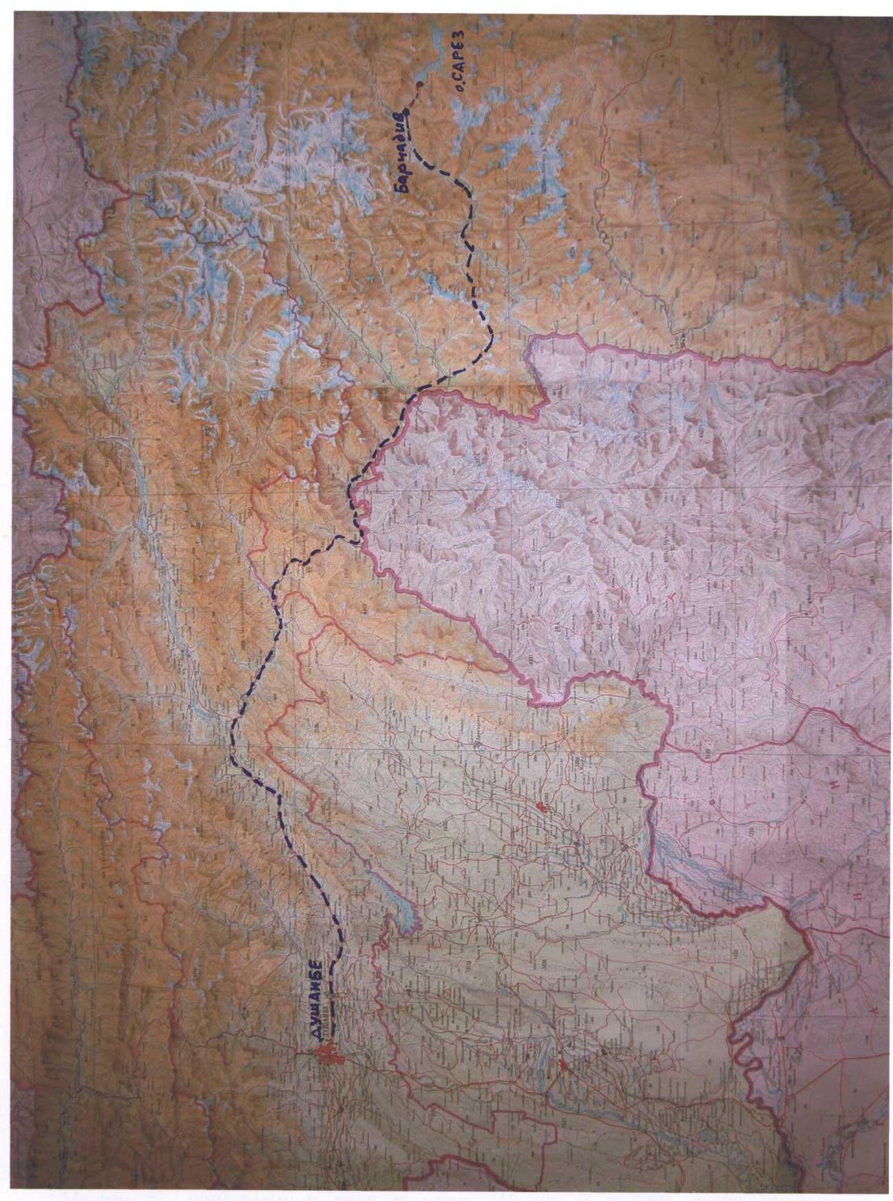
Description of the Saroz Lake mountain area
Road
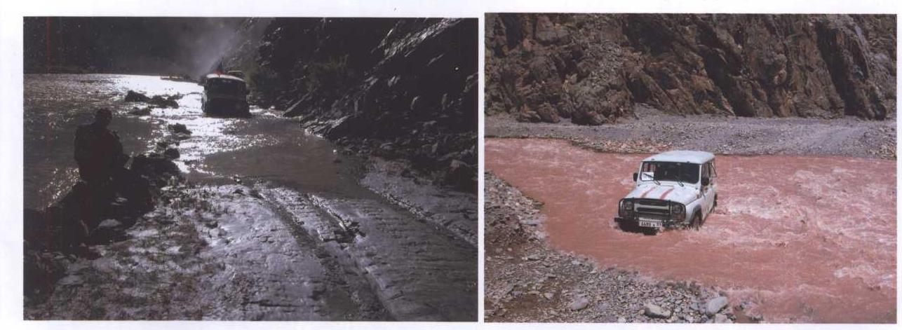
To get to Saroz Lake from Dushanbe:
- By helicopter from Dushanbe airport to the helicopter pad on the Usoi dam;
- By car. Drive to the district center Rushan. The road to the turnoff to Rogun has asphalt coverage. Further, the asphalt is practically absent, and the coverage is badly damaged. From Rushan, it's 130 km to the village of Barchadiv — a difficult road. You need to cross several rivers. With high water, the road is sometimes flooded and washed away. The journey takes 2-3 days.
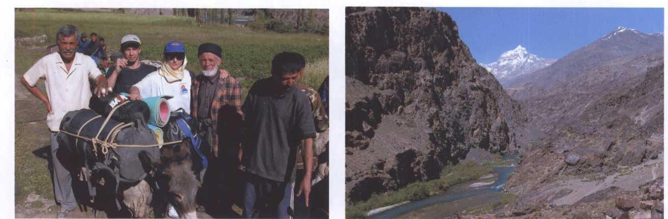
From the village of Barchadiv, it's a 20 km hike. It takes about the same time to go up and down — from 6 to 10 hours.
- At the beginning of the path (1 hour) and at the end (2 hours), there is no water.
- In the middle part, the trail runs along the Murgab River.
- The most steep section with a difference of 700 m is a long climb to the Usoi dam.
- The climb consists of three stages.
Features of the area
Due to the possibility of a breakthrough of the Usoi dam, the Saroz Lake area is a strategic object and is closed to tourism. To visit it, in addition to a permit to enter the border zone of the GBAO, you need to obtain a special permit. As a rule, sports and tourist groups are not allowed to visit the Usoi dam area.
There are more than three dozen peaks in the area with heights of 4000-5900 m. The area is interesting for mountaineering ascents. You can make ascents on:
- rock routes 2-5 cat. diff.
- combined routes 2-5 cat. diff.
- ice routes 2-5 cat. diff.
A major difficulty is the lack of trails along the coastline. It's best to get to various gorges in the area by boat, which is available to the employees of the Ministry of Emergency Situations.
The approaches are characterized by a large gain in height.
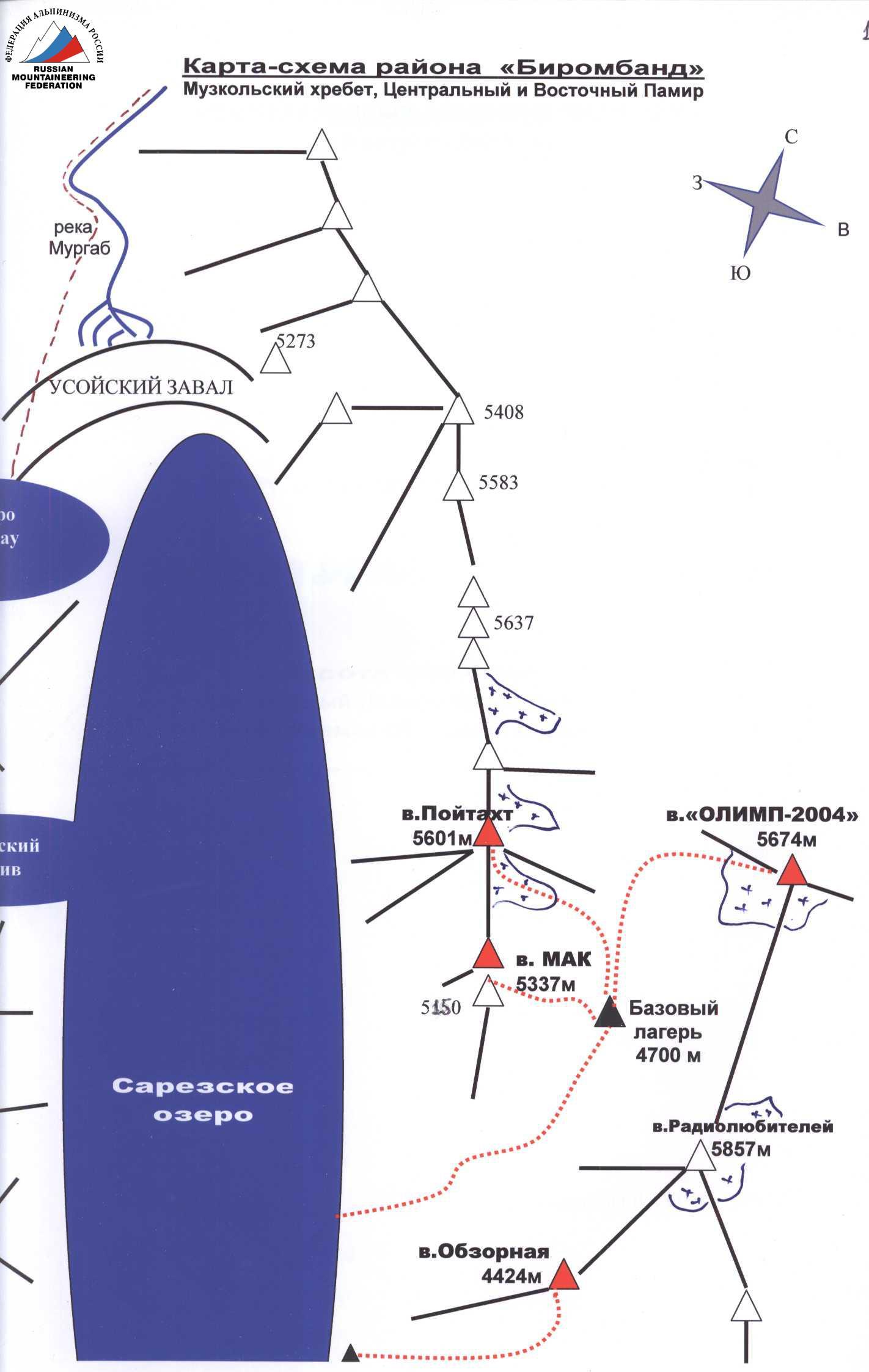
Birombnd Area
Located on the right bank of Saroz Lake. The ridge stretches along the lake for 35 km and continues north to the village of Barchadiv. The area includes 10-15 peaks. The highest peak is "Radio Lyubitelei" (5857 m), where a radio repeater was installed in 2002 by climbers from Dushanbe (V. Khabibulin, A. Maskayev, I. Karatyschev). No other mountaineering ascents were made in the area before 2003.
Ascents can be made from the southwest, from the lake, and from the northeast, from the gorge.
There is practically no water in the area in the summer. All streams emerge to the surface near the lake shore. On the southwestern slopes, there is no snow in July-August. And in the northeast, there are glaciers and snow in the upper reaches.
The International Mountaineering Club team made all their ascents from the northeast.
From the МЧС house, take a boat (10 km) around the right-bank landslide slope and enter the gorge. Walk up the gorge along the middle talus for 5 hours. Establish a base camp at an altitude of 4700 m. From here, ascents are made to the peaks "Olimp", "Poytakt", "MAK". When ascending to "Olimp", you can set up a storm camp at an altitude of 5000-5100 m up the gorge.
In the area, the rock formations are heavily destroyed.
Shadau mountain area
Named after the Shadau River and Lake. There is water everywhere in the area. There is significant glaciation on the northern slopes. There are complex routes.
From the МЧС house, take a boat (6 km) across Lake Shadau to the mouth of the river. Walk along the right bank of the river (in the direction of travel) along the trail for 3 hours. Cross the first right tributary (Khalifa Ilga river) and start climbing up and to the right along the slope (2 hours).
Through a vaguely expressed watershed, enter the gorge and walk along the Juztakhac river to the grassy fields (to the right of the black moraine, clearly visible from Lake Shadau). In the summer, a herd of yaks grazes on the meadow (without a shepherd). Be careful — the yaks can be aggressive. It's convenient to set up a base camp near large stones next to the yak meadow. There is a stream.
The entire approach from the МЧС house to the base camp (4300 m) takes 5-7 hours.
For the ascent to the peaks "10 лет МЧС", 5350, 5535, you can set up a storm camp in the upper part of the gorge, at an altitude of 4600 m (it takes 2.5 hours to walk).
From the base camp, the peaks 5000, 5050, 5350, 5535, and USOY are visible.
Information about Saroz Lake
History of the lake's formation
On the night of February 5-6, 1911, a strong earthquake occurred in the central part of the Pamir Mountains (currently in the Gorno-Badakhshan Autonomous Region of the Republic of Tajikistan). As a result of the seismic impact, a giant landslide occurred in the valley of the Murgab River, which was named the "Usoi dam" in memory of the village of Usoi, which was buried by it. All the inhabitants of the village died. The landslide deposits blocked the Murgab River and caused the formation of a large lake.
Saroz Lake is located between the North Alichur and Muzkol ranges, at an altitude of 3239 m.
- Area: 86.5 km²
- Length: about 75 km
- Width: up to 3.4 km
- Average depth: 190 m
- Maximum depth: 550 m
The lake is primarily fed by glaciers. The range of level fluctuations is about 6 m.
- Freezes in late December — early January
- Opens in late March — May.
The average annual level of Saroz Lake rises by 0.2 m. From 1967 to 2001, it rose by 4.8 m. The excess of the lowest point of the watershed ridge of the Usoi dam over the lake:
- 41 m under normal conditions;
- can decrease to 32-35 m during a high-water flood.
The unique lake is a natural pearl, a scientific object, and at the same time the most serious potential threat to the whole of Central Asia. Scientists predict the inevitability of a lake breakthrough and the occurrence of a catastrophic mudflow along the Pyanj River. The destruction zone includes territories:
- Tajikistan,
- Uzbekistan,
- Turkmenistan,
- Afghanistan,
where more than 5,000,000 people live, as well as all Russian border outposts located on the Tajik-Afghan border.
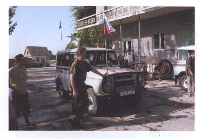
Until 1991, geologists and scientists from all over the Soviet Union regularly worked in the lake area. From 1991 to 2003, there were practically no scientific observations at Saroz. Currently, a monitoring and warning station of the Ministry of Emergency Situations of the Republic of Tajikistan is operating year-round in the Usoi dam area. The МЧС house is located between two lakes: Saroz and Shadau. In 2005, another house will be put into operation, located directly on the dam. Next to it, a helicopter pad is being built.
In 2003-2004, the International Mountaineering Club, together with "Tsentrspas" of the Ministry of Emergency Situations and the Ministry of Civil Defense of the Republic of Tajikistan, organized two scientific and sports expeditions, during which:
- 8 first ascents were made;
- the coastline of the lake was surveyed;
- a rafting trip was made along the Murgab and Bartang rivers to the Pyanj River;
- the first diver's dive into the lake was made;
- underwater video filming was performed.
No information about mountaineering ascents in the area before 2003 was found. The journey from Dushanbe to Saroz Lake:
- 2-3 days by car
- 1 day on foot
Base of "Tsentrspas" of the Ministry of Emergency Situations of the Republic of Tajikistan (former base of the KSP of Tajikistan)
Head: Colonel A.V. Pilkevich
Road along the Bartang River (from the turnoff from the Pamir highway to the village of Barchadiv)
Road along the Murgab River from the village of Barchadiv to Saroz Lake
- 20 km on foot
- possible to ride pack animals
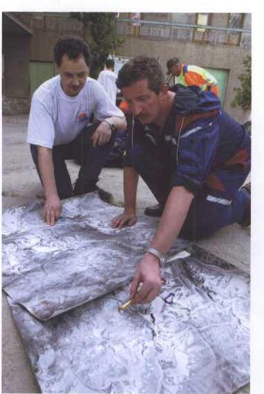
Map of Saroz Lake
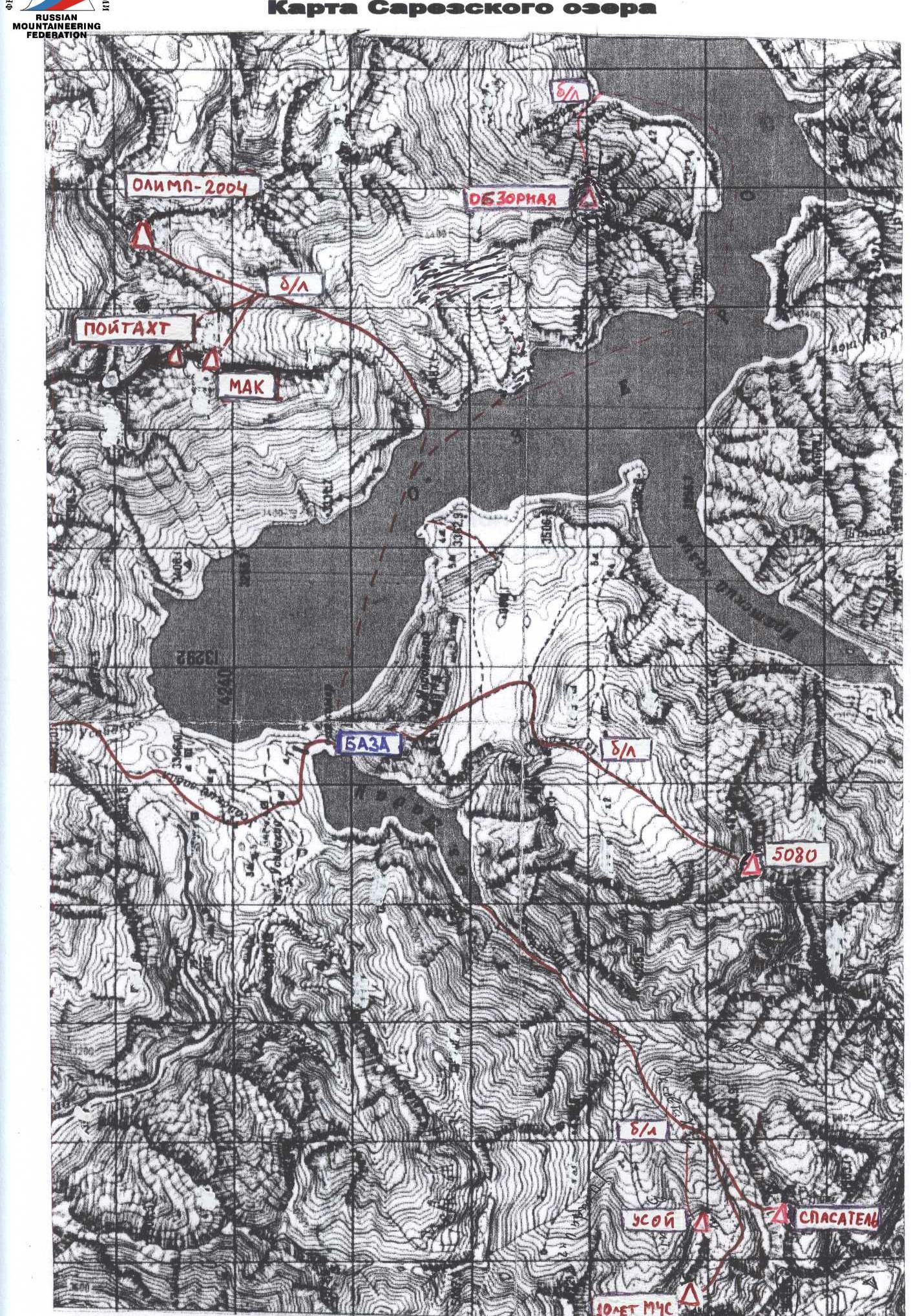
"Birombnd" Area
Map of the "Birombnd" area
Muzkol Range, Central and Eastern Pamir
International Mountaineering Club
August 13, 2004
Report on the Ascent to the Peak
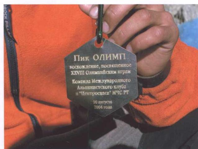
"Olimp-2004"
height 5674 m
Central Pamir, Muzkol Range
The proposed route difficulty is 3A
Ascent Passport
-
Area — Eastern Pamir, Muzkol Range
Republic of Tajikistan, Gorno-Badakhshan Autonomous Region
-
Peak — "Olimp-2004". Height 5674 m
-
Peak coordinates: N 38°17.093′ E 072°42.198′ (measured by GPS)
-
Route — via Western Ridge
-
Proposed — 3A cat. diff., first ascent
-
Route character — combined
-
Route characteristics: height difference — 950 m, route length — 1900 m
-
Equipment used on the route: pitons — 30 (rock — 18, ice — 12)
-
Number of climbing hours — 13 hours
-
Participants: Vladimir Khabibulin (Candidate for Master of Sports, Tajikistan), Shabon Yaftaliev (3rd class, Tajikistan)
-
Date of ascent: August 13, 2004
Departure from base camp — 8:00, August 12. Summit — 9:30, August 13. Return to base camp — 12:00, August 13
-
Organization: International Mountaineering Club "Tsentrspas" of the Ministry of Emergency Situations and Civil Defense of the Republic of Tajikistan
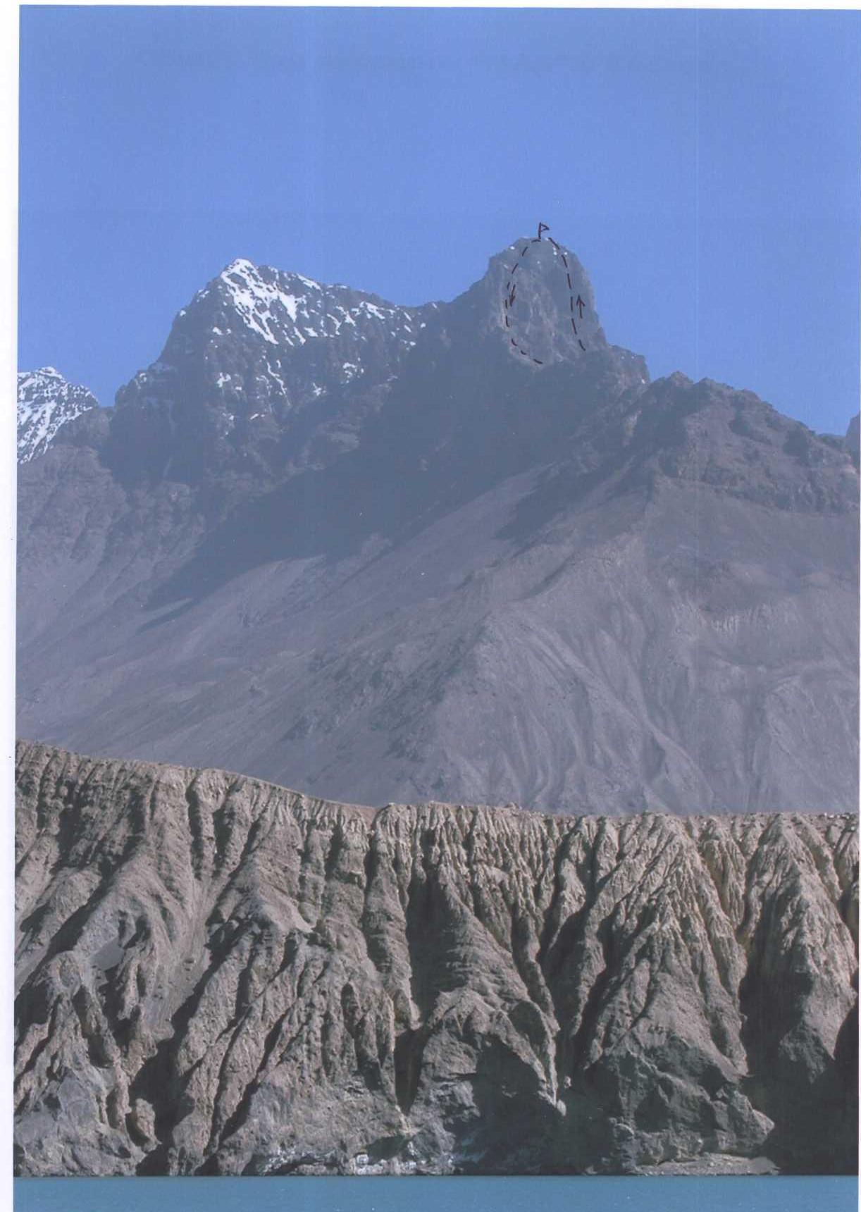
General view of the peak "Olimp-2004"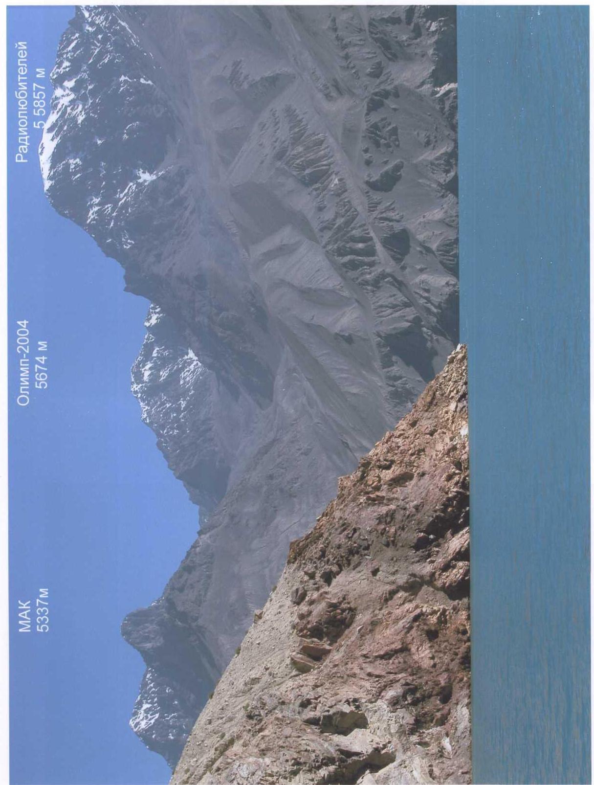 On the summit!
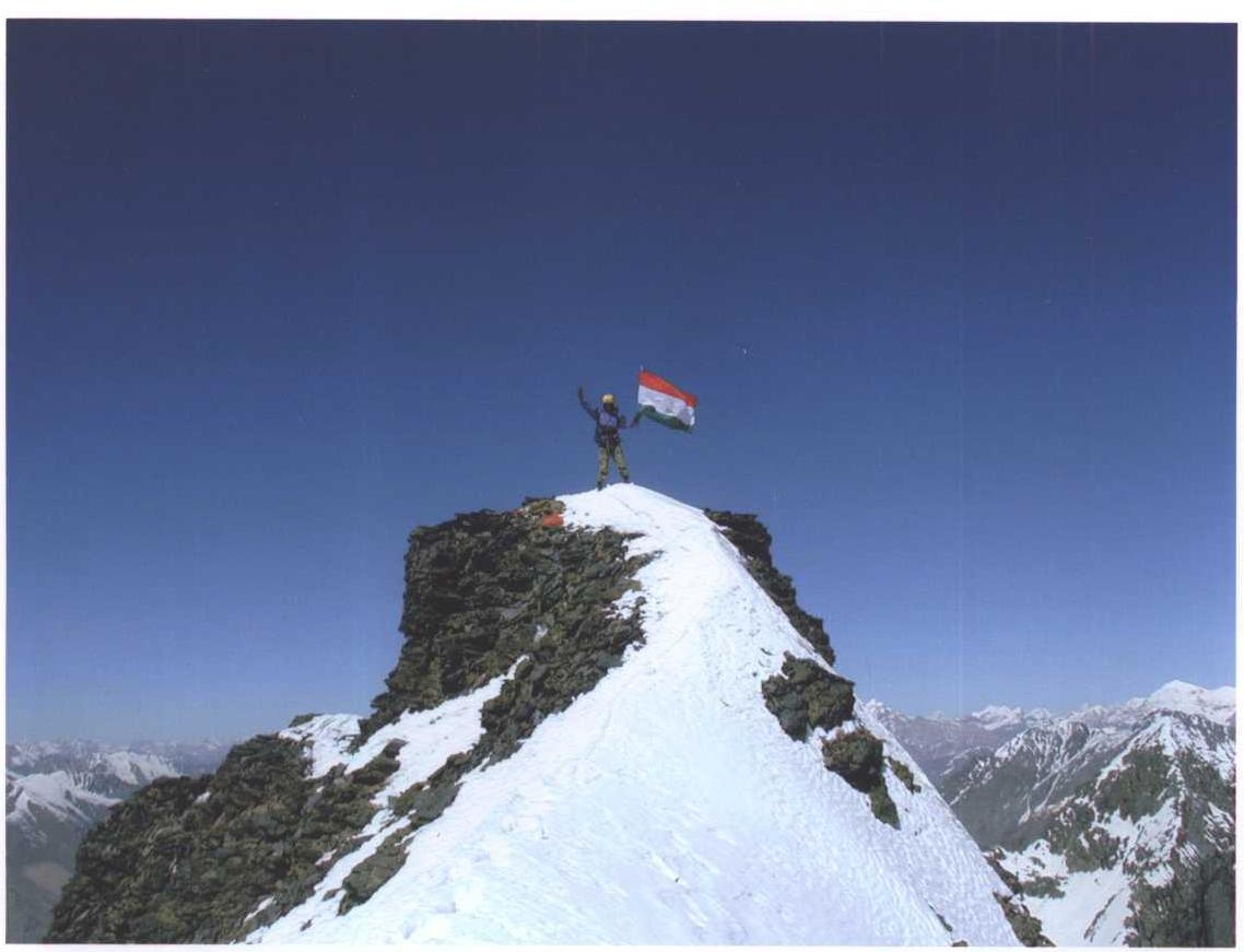
Route profile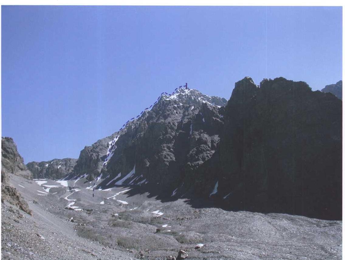 Section 02. Snow-ice couloir
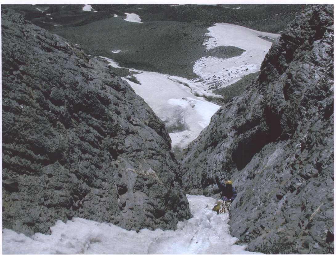
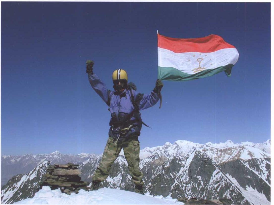
Photo from the summit. In the lower left corner, the Moscow pass and the Western ridge
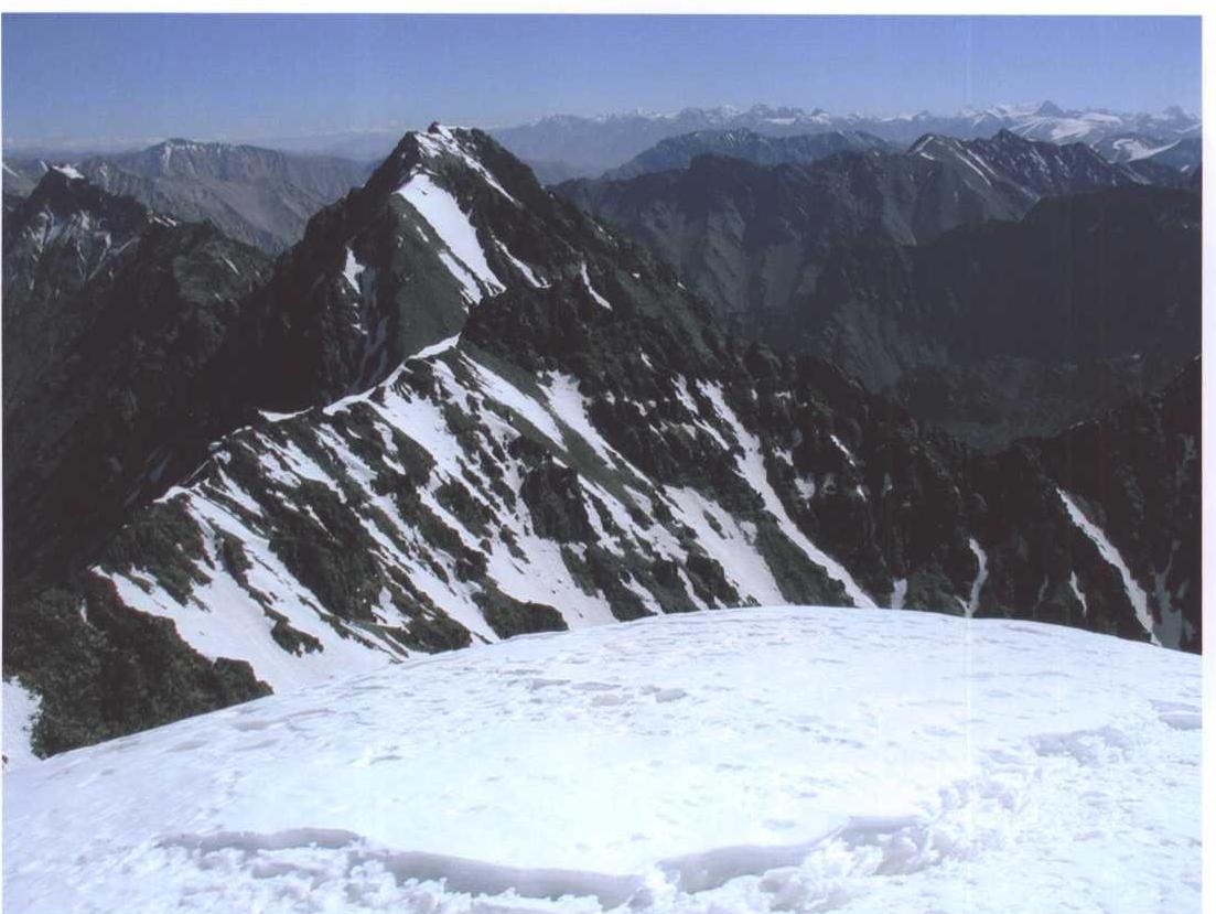
View from the summit to the West
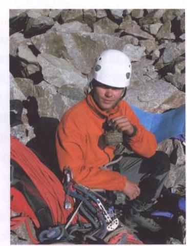
Plaque on the summit
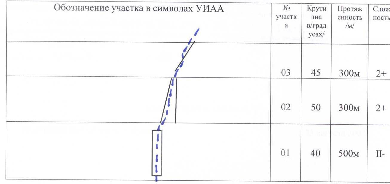
Route diagram in UIAA symbols to the peak "Olimp-2004" (5674 m)
| UIAA Section designation | Section number | Steepness (°) | Length (m) | Difficulty |
|---|---|---|---|---|
| 6 | 30° | 150 m | II | |
| 5 | 50° | 70 m | III | |
| 4 | 40° | 250 m | II+ | |
| 3 | 40° | 200 m | II | |
| 2 | 55° | 300 m | II+ | |
| 1 | 60° | 400 m | II− |
Route Description
to the peak "Olimp-2004"
The route starts from the 4700 m camp on the Bizangov glacier. Move up the glacier to the Moscow pass 5050 m. 300 m before the saddle, there is a steep snow-ice couloir that bypasses the difficult rock section and allows you to reach the western ridge of the peak.
- In the couloir, belaying is necessary on a 200 m section.
- The average steepness of the couloir is 50°, with some sections up to 65°.
After passing the couloir, there is a relatively simple rock-ice section that is climbed with simultaneous belaying on a 200 m section.
At an altitude of 5100 m, it is advisable to set up a storm camp to acclimatize and start early in the morning, as the snow on the northwest side of the ridge is deep and loose, and it needs to be traversed early in the morning.
- The ascent should start at dawn, around 5:30.
- Move along the snow-rock ridge to the pre-summit gendarme.
- The gendarme is bypassed on the right with belaying along the rock-ice slope with a steepness of up to 50°.
After bypassing the gendarme, return to the ridge and move to the rocky dome of the summit along simple rocks to an altitude of 5600 m. The ascent to the summit is rock-ice, to the mark 5681 according to GPS and 5674 according to the topographic base.
The ascent takes:
- 4 hours to the 5100 m camp,
- another 4 hours to the summit.
The descent is целесообразно to make along the northwestern ridge, but slightly descending from the summit towards the Temurkul-Dzhilga river and then traversing the same slope, but along the snowy slope, bypassing the main gendarme. The further descent is along the ascent route and takes 6 hours to the mark 5050 m.
The ascent from the 4700 m camp takes 13 hours.
Ministry of Emergency Situations and Civil Defense of the Republic of Tajikistan
Dushanbe, Lohuti str. 26, 734013, Tel. 23-28-18, Fax 21-13-31. No. 24/1026 dated August 19, 2004.
Certificate
Republic of Tajikistan, Dushanbe, August 25, 2004.
Issued to the team of the International Mountaineering Club (IMC), which made the first ascent to the peak with a height of 5674 m in the Muzkol Range (Eastern Pamir, Gorno-Badakhshan Autonomous Region, Republic of Tajikistan) on August 13, 2004.
Team members: Vladimir Khabibulin (Candidate for Master of Sports, Tajikistan), Shabon Yaftaliev (Tajikistan). Team coach: Yuri Baykovsky (Honored Coach of the Republic of Tajikistan). The peak was named "Olimp-2004". Location of the peak: N 38°17.093′ E 072°42.198′.
Head of the Control and Rescue Service of the Republic of Tajikistan, Head of "Tsentrspas" of the Ministry of Emergency Situations and Civil Defense of the Republic of Tajikistan, Colonel A.V. Pilkevich.
Minister of Emergency Situations and Civil Defense of the Republic of Tajikistan, Major General M.A. Ziyoyev.
International Mountaineering Club
August 11, 2004
Report on the Ascent to the Peak
"Poytakt" (Capital)
height 5601 m, Eastern Pamir, Muzkol Range. Proposed route difficulty 2A
Ascent Passport
-
Area — Central Pamir, Rushan Range
Republic of Tajikistan, Gorno-Badakhshan Autonomous Region
-
Peak — "Poytakt" (Capital), height 5601 m
named in honor of the 80th anniversary of the capital of Tajikistan, Dushanbe
-
Peak location: N 38°17.150′ E 072°40.550′
-
Route — via Southern Ridge
-
Proposed — 2A cat. diff., first ascent
-
Route character — combined
-
Route characteristics: height difference — 1000 m, route length — 1400 m
-
Equipment used on the route: pitons — 30 (28 rock, 2 ice)
-
Number of climbing hours — 12 hours
-
Team members:
Leader — Vladimir Khabibulin (Candidate for Master of Sports, Tajikistan) Participants: Shabon Yaftaliev (Tajikistan), Alexander Onishchenko (1st class, Tajikistan), Igor Loginov (2nd class, Russia)
-
Team coach: Yuri Viktorovich Baykovsky (Honored Coach of the Republic of Tajikistan)
-
Date of ascent: August 11, 2004. Time of summit — 13:00
-
Organization: International Mountaineering Club "Tsentrspas" of the Ministry of Emergency Situations and Civil Defense of the Republic of Tajikistan
Peak "Poytakt" 5601 m, photo from the Murgab gorge below the Usoi dam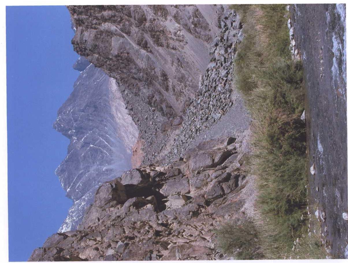
Peak "Poytakt" 5601 m, photo from Saroz Lake! 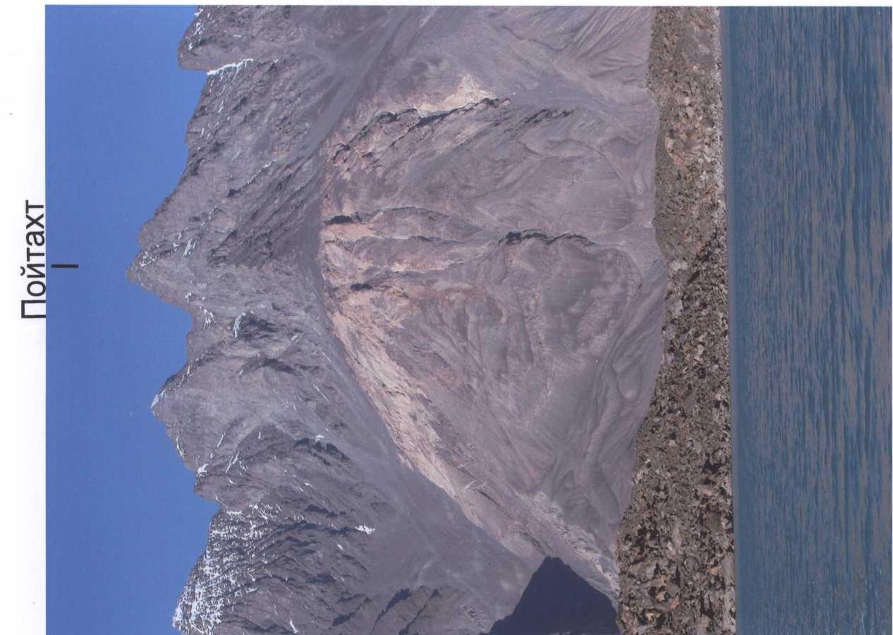
Route to the peak "Poytakt"
photo from the ridge of peak "Olimp-2004" from the East! 
On the summit
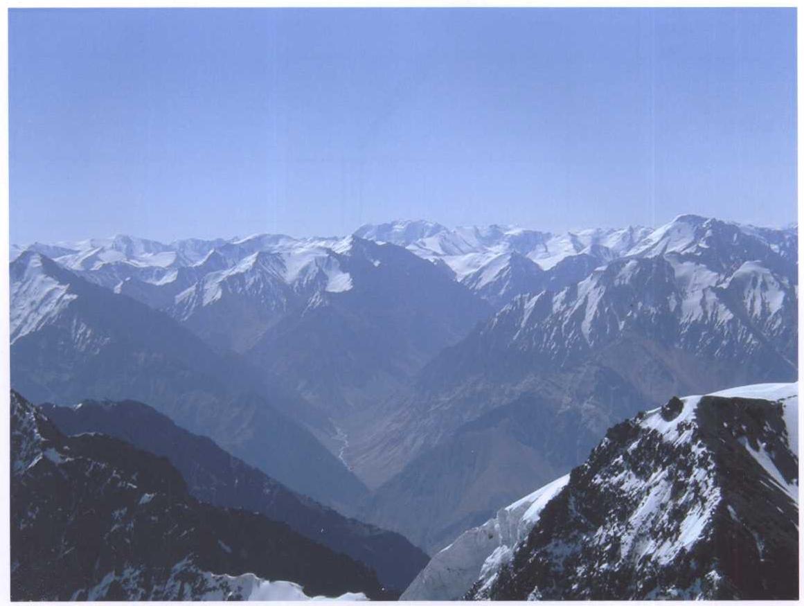
photo taken towards the upper reaches of Saroz Lake to the South! 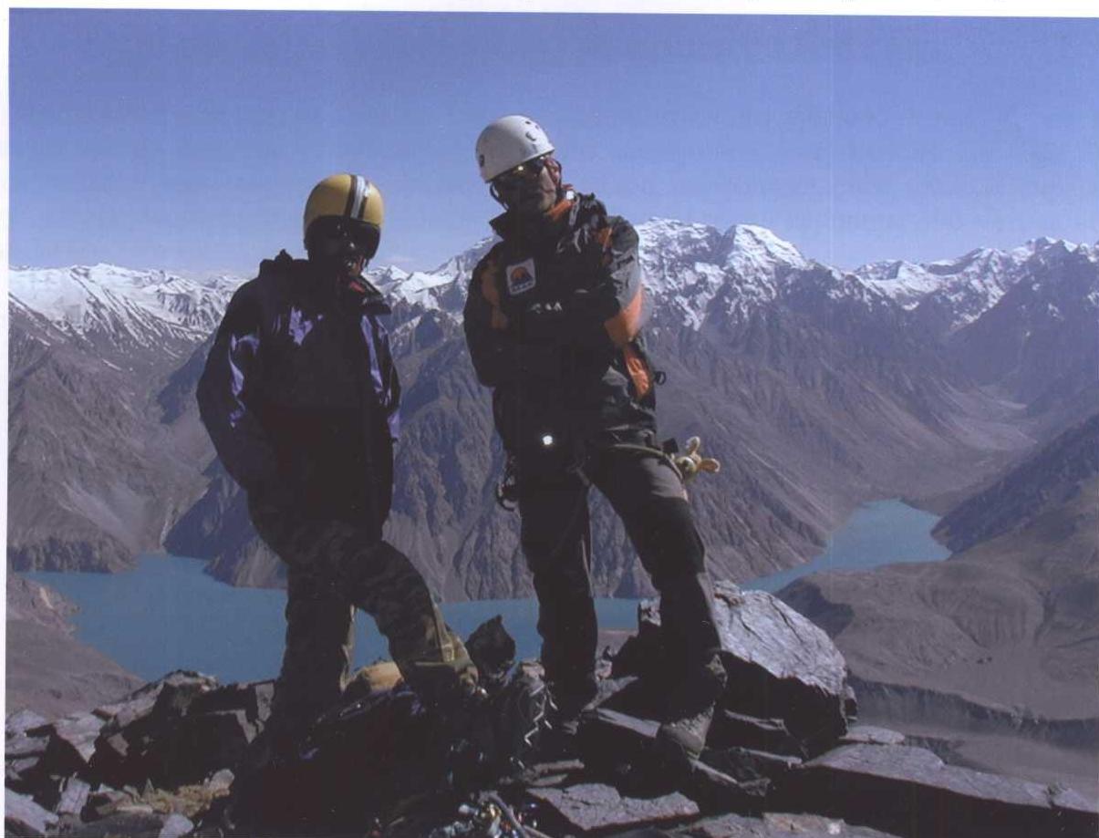
Route diagram in UIAA symbols
Route description to the peak "Poytakt"
From the base camp at an altitude of 4700 m, climb up the gorge for 1 hour. Then, to the saddle between peak "Poytakt" and "MAK" along the snow-ice slope for 2.5 hours. In the upper part, crampons are needed. In the upper part, the slope becomes more gentle. Bypassing the moraine on the right, turn right and walk along the ridge in the direction of the peak for 300 m along the snow-ice fields with rock outcrops (R1).
Along the steep snow-ice couloir, climb to the shoulder of the ridge (R2). Along the ridge to the summit for 300 m (R3).
Descent is along the ascent route. The ascent takes 8 hours.
Ministry of Emergency Situations and Civil Defense of the Republic of Tajikistan
Dushanbe, Lohuti str. 26, 734013, Tel. 23-28-18, Fax 21-13-31. No. 24/1026 dated August 28, 2004.
Certificate
Republic of Tajikistan, Dushanbe, August 25, 2004.
Issued to the team of the International Mountaineering Club (IMC), which made the first ascent to the peak with a height of 5601 m in the Muzkol Range (Eastern Pamir, Gorno-Badakhshan Autonomous Region, Republic of Tajikistan) on August 11, 2004.
Team members: Vladimir Khabibulin (Candidate for Master of Sports, Tajikistan), Alexander Onishchenko (1st class, Tajikistan), Igor Loginov (2nd class, Russia), Shabon Yaftaliev (Tajikistan). Team coach: Yuri Baykovsky (Honored Coach of the Republic of Tajikistan). The peak was named "Poytakt" (Capital). Location of the peak: N 38°17.150′ E 072°40.550′.
Minister of Emergency Situations and Civil Defense of the Republic of Tajikistan, Major General M.A. Ziyoyev.
International Mountaineering Club
August 15, 2004
Report on the Ascent to the Peak
International Mountaineering Club
height 5337 m, Central Pamir, Rushan Range. Proposed route difficulty 4B
Ascent Passport
-
Area — Central Pamir, Rushan Range, Republic of Tajikistan, Gorno-Badakhshan Autonomous Region
-
Peak — "International Mountaineering Club". Height 5337 m
-
Peak coordinates: N 38°16.450′ E 072°40.960′
-
Route — via internal angle of the Eastern wall
-
Proposed — 4B cat. diff., first ascent
-
Route character — rock
-
Route characteristics: height difference — 630 m, route length — 950 m
-
Equipment used on the route: pitons — 14, chocks — 63
-
Number of climbing hours — 14 hours
-
Participants: Alexander Onishchenko (1st class, Tajikistan), Igor Loginov (2nd class, Russia)
-
Team coach: Yuri Viktorovich Baykovsky (Honored Coach of the Republic of Tajikistan)
-
Date of ascent: August 15, 2004.
Departure from base camp — 9:00, August 14. Summit — 12:00, August 15. Return to base camp — 12:30, August 15
-
Organization: International Mountaineering Club "Tsentrspas" of the Ministry of Emergency Situations and Civil Defense of the Republic of Tajikistan
General view of the peak from the Irkht bay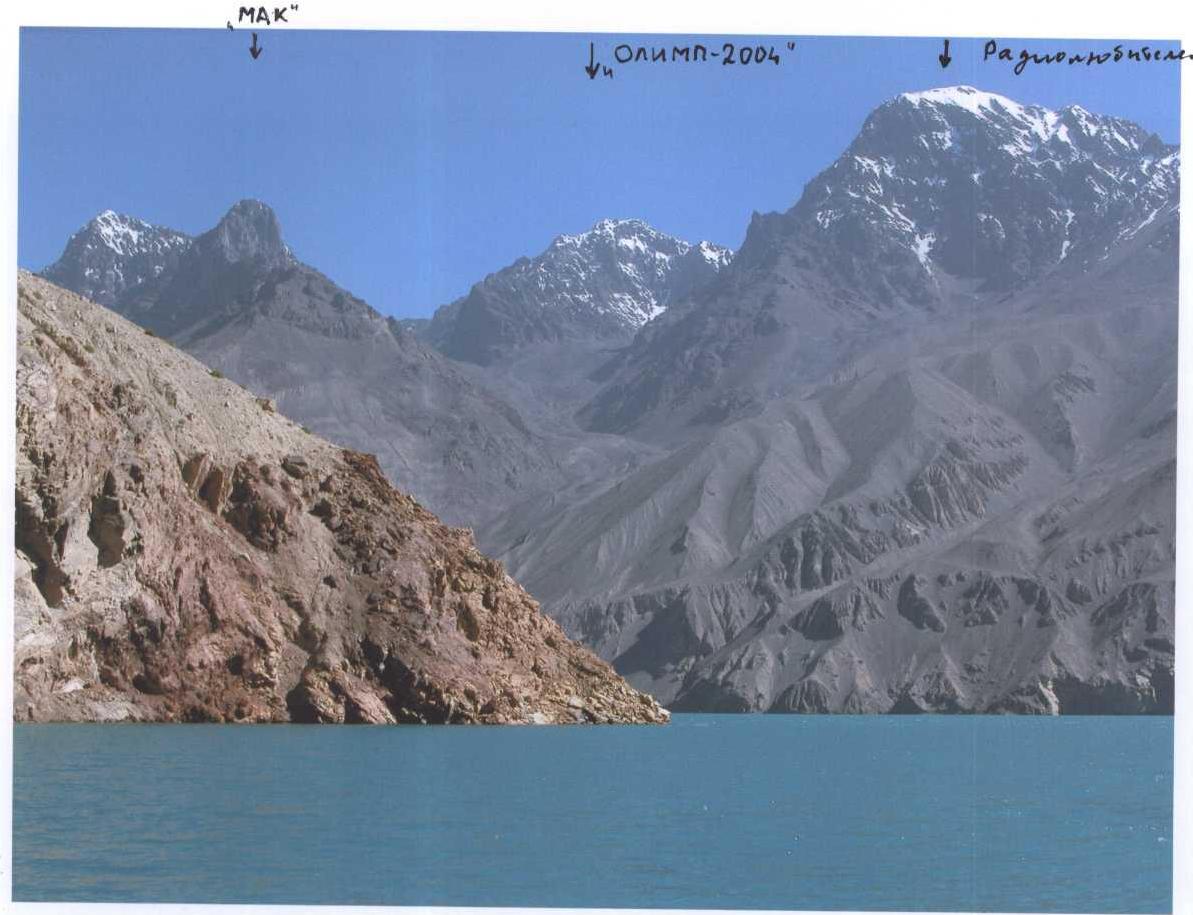
Start of the route
General view of the peak "MAK"
 General view of the peak "MAK" from the East
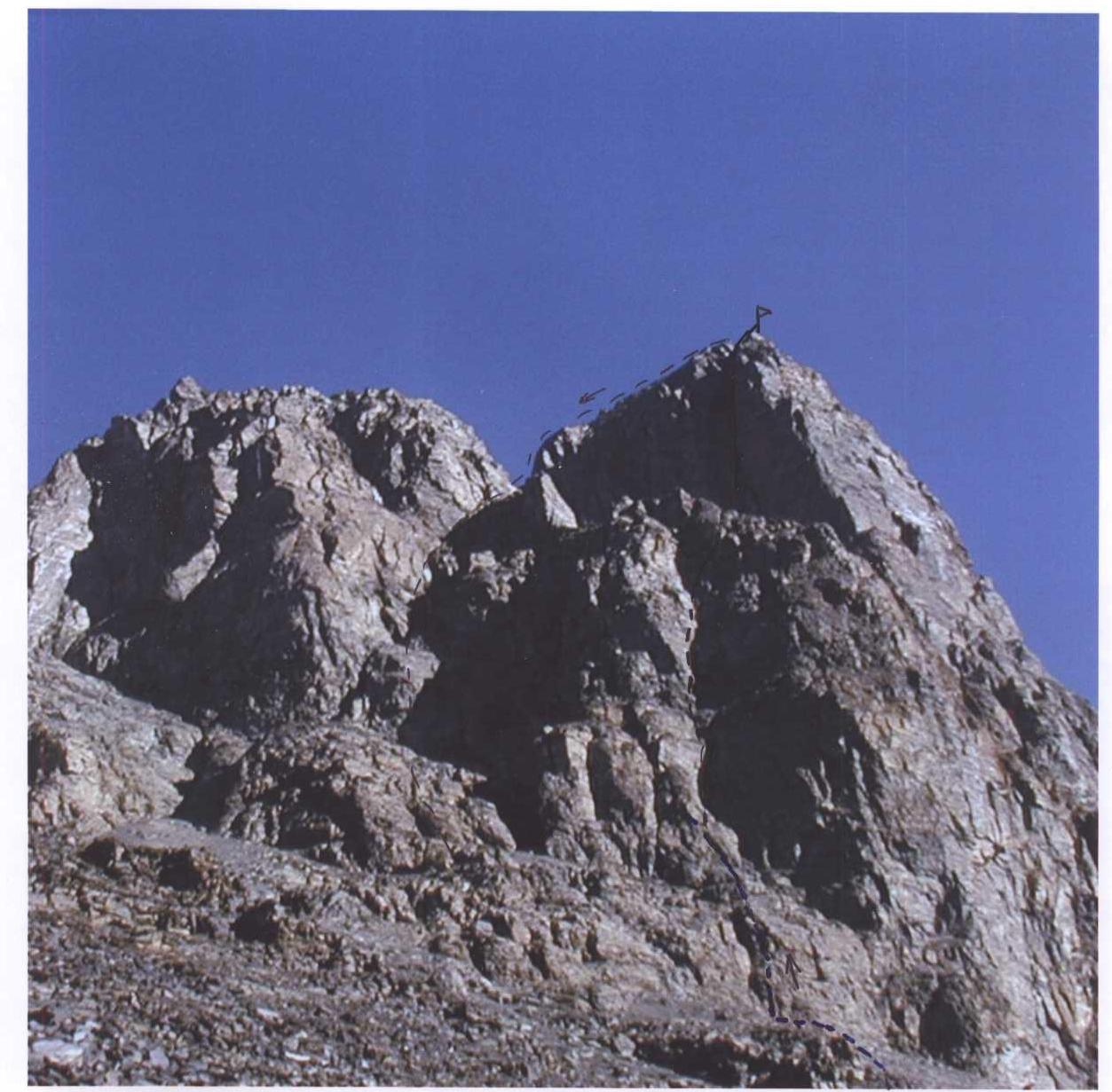
View from the summit to the Irkht bay
on the left below shoulder 5150 m
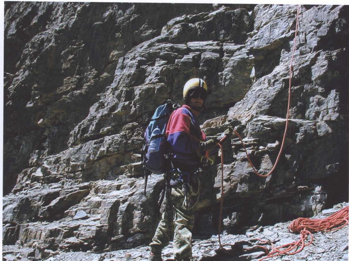
On the route. Section 06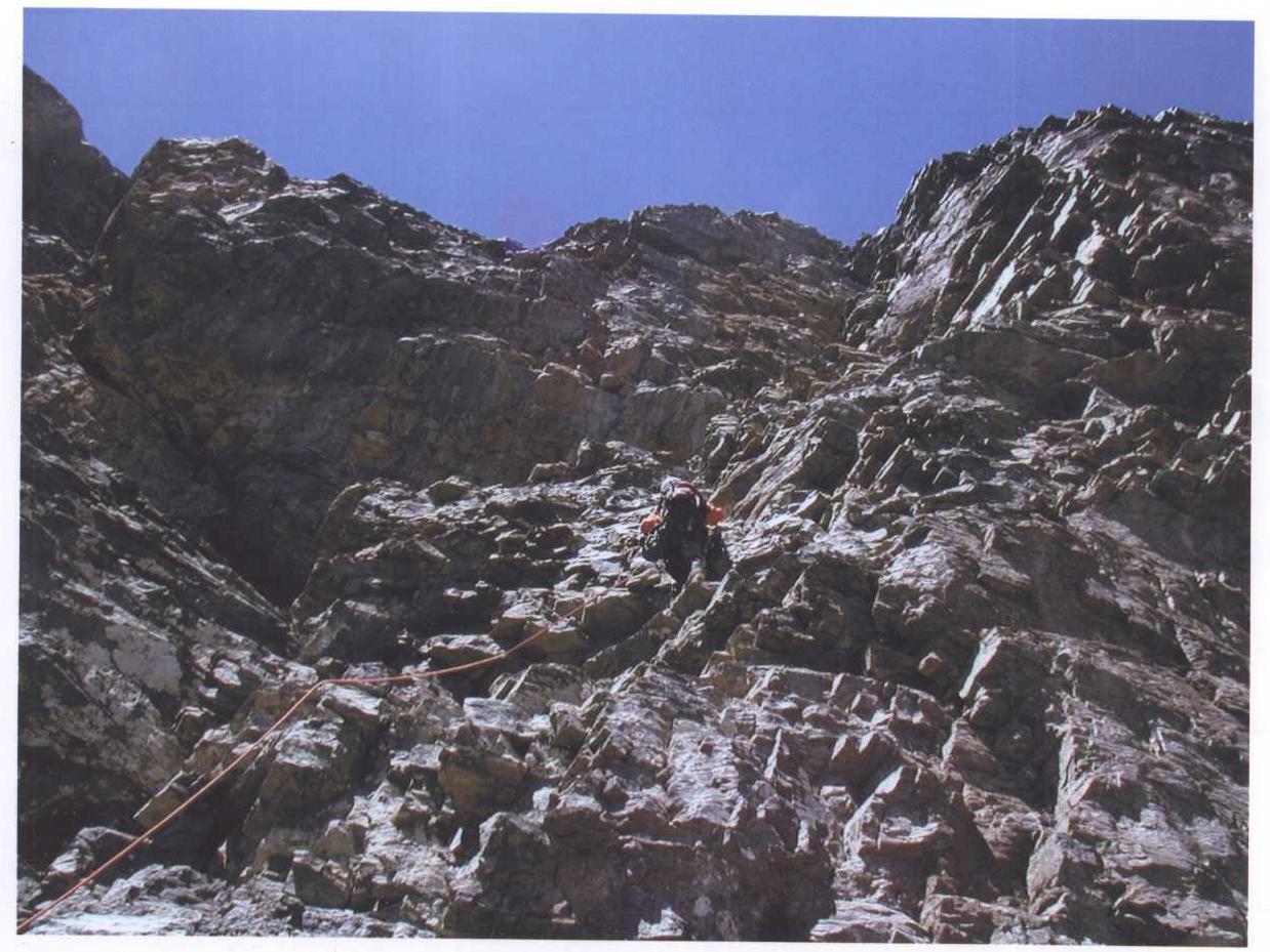
Route diagram in UIAA symbols
to the peak 5337 m
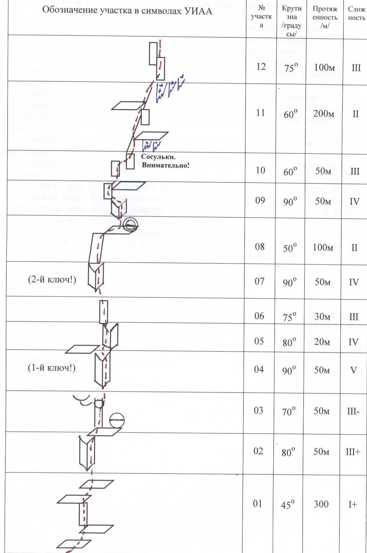
Route description to the peak 5337 m "International Mountaineering Club"
From the 4770 m camp, move towards the peak along the talus shelves for 300 m. The approach takes 30 minutes. The start of the route is a clearly expressed internal angle at the base of the rock massif. Climb up the internal angle for 50 m (R2). The rocks are destroyed. Use stoppers and excentrics. Good belay on the shelf.
From the shelf, move to the right and then up along the chimney with a plug in the upper part (R3). (Attention — the rocks are destroyed). Good belay on the shelf.
Along the internal angle (R4), one rope of very difficult climbing (Key!). Use:
- pitons,
- hexes,
- friends.
Further, 20 m along the internal angle (R5) and 30 m along the wall of destroyed rocks (R6). Use:
- stoppers,
- hexes,
- pitons.
Belay on the shelf.
50 m along the internal angle (R7) with an overhang (second key section!). Climbing is difficult. Use:
- stoppers,
- pitons,
- excentrics.
100 m up the wall (R8) to the right under the cornice. Under the cornice — a convenient place for an overnight stay.
From the overnight stay, climb up the internal angle for 30 m, turning into a wall for 20 m (R9), and exit to a shelf. Icicles hang from the shelf, 2-3 m long. Be careful! Icicles can:
- fall down on the belayer;
- fall on the person climbing along the rope.
Use stoppers and pitons.
50 m along the destroyed rocks, move to the right to a shoulder (R10). From the shoulder, along the ridge to the right towards the peak for 200 m along the destroyed shelves (R11). Climbing is not difficult, you can go simultaneously. (Be careful, icicles can fall from the summit).
Along the wall to the summit for 100 m. The rocks are destroyed. Use stoppers. The summit is dome-shaped. Destroyed rocks, snow.
Descent:
- First, 250 m along the ascent route.
- Then, with cross belaying through ledges to a clearly expressed shoulder.
- From the shoulder, left along the talus shelves for 600 m to the base camp at 4700 m.
The entire ascent takes 14 hours.![img-31.jpeg]({"width":1350,"height":245,"format":"Jpeg","uri":"https://summitx.info/media/1/Xut5KRcje↗