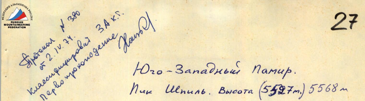
27
Southwestern Pamir. Peak Shpil. Elevation (5527 m) 5568 m
Report on the first ascent via the eastern ridge, category 4A difficulty, made by a group from the Kharkov regional council of the "Avangard" sports society on June 20, 1973, consisting of:
- Slobodyanik L.I. – 2nd sports category – leader
- Spesivtsev A.E. – Master of Sports
- Kovalinskaya L.P. – 2nd sports category
- Eremenko G.N. – 2nd sports category
Kharkov, 1973
Contents
- Group composition.
- Object characteristics.
- Map diagram.
- Photographs of the object broken down by sections.
- Route description.
- Route recommendations.
- Route assessment.
- Table of main route indicators.
1. Group Composition
- Slobodyanik L.I. – 2nd sports category, Kharkov (leader)
- Spesivtsev A.E. – Master of Sports, Kharkov
- Kovalinskaya L.P. – 2nd sports category, Kharkov
- Eremenko G.N. – 2nd sports category, Kharkov
2. Object Characteristics
Peak Shpil is located in the Southwestern Pamir in the Shakhdarin range on the watershed of the Garms-Chatma, Bidzhuar-dara, and Ab-kharv-dara rivers, with an elevation of 5497 m.
Back in 1931, P. Luknitsky, while conducting cartographic surveys in this area and reaching the source of the Bidzhuar-dara, marked an unnamed peak on the map, approximately 5500 m high, which blocks the Bidzhuar-dara gorge. He was searching for a pass to the Garms-Chatma gorge from there but did not find one.
Currently, it is possible to move from the Garms-Chatma gorge to the Bidzhuar-dara gorge via the Desyati pass.
In 1970, a group of Kiev tourists visited this area and drew attention to this peak, indicating the possibility of ascending it from the side of the Bidzhuar-dara glacier.
In 1971, a team from the Kharkov regional council of the "Avangard" sports society attempted to ascend Shpil via the wall. They also noted the possibility of ascending it from the side of the Bidzhuar-dara glacier via the northeastern snowfields, exiting onto the eastern ridge. In the same year, a group of Leningrad climbers led by E. Petrov successfully ascended Shpil via the western ridge.
5. Route Description
From the village of Garms-Chatma to the Desyati pass – 10–12 hours of ascent. From the pass, a 50–60 m descent via moderately difficult rocks leads to the Bidzhuar-dara glacier. There are places to camp on the moraine.
It is recommended to start the route around 5–6 am. The route is illuminated by the sun early, causing the snow to soften quickly.
From the campsite, cross the glacier via snowfields, and approach the start of the route in about half an hour. Ascend left-upwards for 300 m (see photo 1) via a snow slope with a gradient of 30–35°. Closed crevasses are possible. The snow has a firn structure.
Then traverse right to avoid a crevasse, ascend 60–70 m, the slope becomes steeper (up to 45°), and traverse left. Then ascend 150 m left-upwards via a very steep snow slope (up to 50°), with loose, deep snow.
Traverse above a crevasse to the right for 150 m, a very dangerous section due to:
- loose snow;
- the slope's steepness, then ascend directly upwards for 20–30 meters and descend into a snow depression before the bergschrund. There are places to camp in the depression.
The bergschrund is overcome using ladders and ice screws.
After the bergschrund, ascend 200 m via a steep (45°) slope with deep snow and exit onto the eastern ridge (see photo 2). There are cornices on the ridge, so it is advisable to walk to the left of the ridge. Ascend 400 m via a slope of 35–40° and reach a 40-meter rock wall. Ascend the rocks (category 4 difficulty) to the pre-summit ridge, along which 3 rope lengths on category 2 difficulty rocks lead to the summit. Descend via the ascent route.
6. Route Recommendations
- Start the route no later than 6:00 am; for later starts, it is recommended to bring a tent and a stove.
- A group size of 4–6 people is recommended.
- Be cautious of avalanches and closed crevasses on the route, and beware of cornices on the ridge.
- When traversing the route at the end of summer, bring crampons.
7. Route Assessment
Based on the group's prior experience with routes (Zaromag, Adai-khokh), the group assessed the route as category 4A difficulty. The same assessment was given by the team from the Kharkov regional council of the "Avangard" sports society, which ascended Shpil via the wall and descended via this route.
8. Table of Main Route Indicators
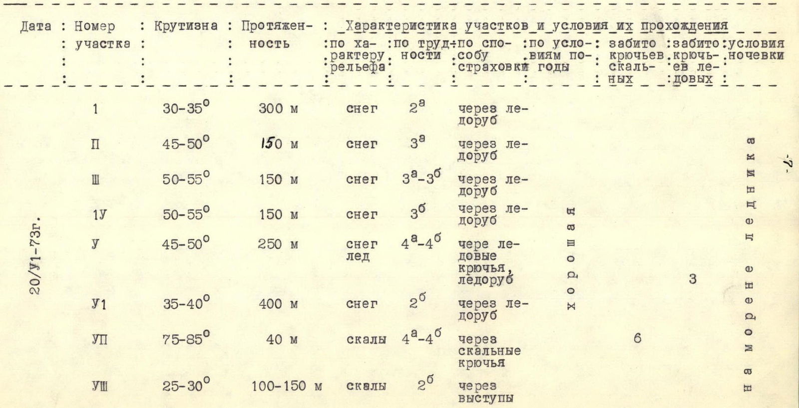
| Date | Section No. | Steepness | Length | Relief Characteristics | Section Difficulty | Insurance Method | Weather Conditions | Rock Screws | Ice Screws | Camping Conditions |
|---|---|---|---|---|---|---|---|---|---|---|
| 20/VI-73 | 1 | 30–35° | 300 m | snow | 2 | via ice axe | ||||
| 2 | 45–50° | 150 m | snow | 3 | via ice axe | |||||
| 3 | 50–55° | 150 m | snow | 3 | via ice axe | |||||
| 4 | 50–55° | 150 m | snow | 3 | via ice axe | |||||
| 5 | 45–50° | 250 m | snow, ice | 4 | via ice screws, ice axe | 6 | 3 | on glacier moraine | ||
| 6 | 35–40° | 400 m | snow | 2 | via ice axe | |||||
| 7 | 75–85° | 40 m | rocks | 4 | via rock screws | |||||
| 8 | 25–30° | 100–150 m | rocks | 2 | via outcrops |