- Climbing category — High-Altitude Technical
- Climbing region — Trans-Alai Range, Dzhanam-Dartakai gorge, upper reaches of Korzhenevsky glacier.
- Peak 5285, First ascent (proposed name: Chelyabinsk Peak) via North-Eastern ridge. Ice and snow.
- Proposed category complexity — 3A.
- Height difference ~ 760 m, average slope ~ 36°.
- Pitons driven — 0.
- Time on the route — 11 hours.
- Number of overnight stays — none.
- Retyunsky Yuri Dmitrievich — Master of Sports of the USSR — team leader
- Leontiev Vasily Viktorovich — Candidate Master of Sports
- Ryabukhin Alexander Grigorievich — Master of Sports of the USSR
- Rabinovich Alexander Borisovich — Candidate Master of Sports
- Retyunskaya Tatyana Dmitrievna — Master of Sports of the USSR
- Badt Vladimir Andreevich — 1st sports category
- Baranovsky Evgeny Alexandrovich — 1st sports category
- Demin Valery Borisovich — 1st sports category
- Zarutsky Anatoly Grigorievich — Candidate Master of Sports
- Karpenkov Mikhail Vladimirovich — Candidate Master of Sports
- Kolokolov Vyacheslav Ivanovich — 1st sports category
- Lapko Alexander Vladimirovich — Candidate Master of Sports
- Misharin Vladimir Alexandrovich — 1st sports category
- Oleinikov Yuri Vladimirovich — 1st sports category
- Prakhov Anatoly Alexandrovich — 1st sports category
- Smirnov Mikhail Glebovich — Candidate Master of Sports
- Soloshenko Alexander Nikolaevich — Candidate Master of Sports
- Samokotin Yuri Timofeevich — Candidate Master of Sports
- Sibayev Mingalim Minsalimovich — Candidate Master of Sports
- Khandyuk Sergey Alexandrovich — 1st sports category
- Cherepanov Alexander Anatolyevich — Candidate Master of Sports
- Vrazhev Yuri Ivanovich — Candidate Master of Sports
- Team coach — Retyunsky Yu.D.
- Date of departure to the route — July 28, 1986 Return — July 28, 1986
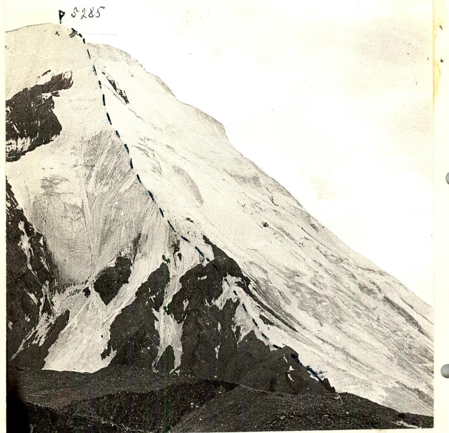
Photo of the summit. (Taken from the moraine of the glacier (4590 m). Lens: Super-Takumar f=50 mm. Distance 500 m)
Brief description of the approach to the route
From the city of Osh by car along the Pamir Highway through Sary-Tash to the former outpost "Bardebe" (211 km). At a right angle to the right across the Kata-Aryk river into the "Dzhanam-Dartakai" gorge 12 km to the base camp at 3600 m.
Then along the right bank of the river (orographically) 4 hours to the camp at 4100 m ("Nagelya Hut").
Then along the northern slopes of the peaks Tankograd and Spartakiada 3 hours to the start of the route to peak 5285.
The route goes along the North-Eastern ridge.
Brief explanation of the diagram
The beginning of the route — scree slope turning into a ridge 600 m, 30°. Then:
- snow and ice ridge ≈ 100 m of ice, slope 30°;
- then along the snowy ridge with alternating belay through an ice axe 500 m, 35°, under ice slopes 50 m long, 50°, belay — ice screws;
- then along the snowy ridge 100 m, 35°, under a rocky outcrop, which is bypassed on the right along an ice slope 100 m, 40°, alternating belay;
- exit to the summit plateau and then to the summit 200 m, simultaneous movement, 15°.
The summit is not clearly defined, a snowy dome.
Route diagram
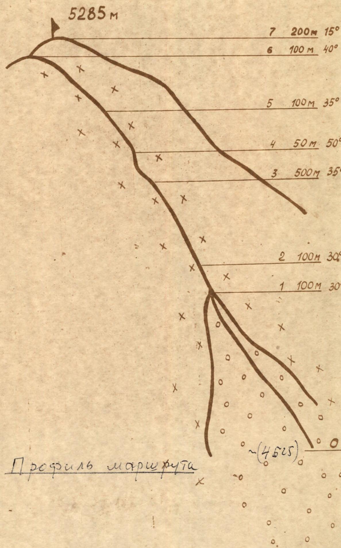
Profile of the route (~4625 m).