PLATEAU 6100 NORTHERN SLOPE OF THE EASTERN RIDGE OF PEAK LENIN
Climbing Description
The ascent route follows the path to Peak Lenin via Lipkin Rock.
Day 1
From the base camp at 3600 m, the path goes through pastures and "Onion Glade" to the foot of "Tent Rock." Then, through a lateral gorge, it follows a trail that leads to a saddle in the ridge named "Travelers' Pass." From "Travelers' Pass," the trail initially descends and then traverses to the right across talus slopes, crosses a canyon, and bypasses a standalone rock on the left. Upon reaching the glacier, a zone of lateral crevasses is encountered. The ice is heavily covered with debris.
The path up the glacier towards Lipkin Rock initially follows its middle part and then, bypassing the icefall on the right, moves to the right orographic moraine, which is a chain of black hills of talus material extending from the foot of Lipkin Rock. The glacier in its upper part is closed, requiring travel in ropes.
At the moraine near the foot of Lipkin Rock, there is a large area suitable for overnight stays, a common stop for many expeditions heading to Peak Lenin from the north. The height of this location is 4200 m. There is water available, and many areas for tents.
The journey from the "Vysochnik" alpine camp to the 4200 m overnight stay took 6 hours. We take a one-hour rest to prepare hot food.
We bypass Lipkin Rock on the right and, entering a wide snowy couloir, ascend through the snow, cutting steps, to the ridge of Lipkin Rock, marked in descriptions as 5200 m. The ascent to Lipkin Rock from 4200 m took 2 hours.
On the ridge, there are many cleared areas for tents, and on the snowy plateau to the left of the ridge, water can be uncovered under the snow. On a terrace below the ridge, the remains of Lipkin's plane are visible.
We set up camp, stretching tents on rocks. This is the last night on the talus, and we take advantage of it.
Due to strong winds, we cut snow bricks on the plateau and build protective walls. Those who didn't do this had to get out multiple times at night to fix their tents.
The wind howls through the rocks all night and shakes the tents, making for a restless sleep. The altitude is also starting to be felt.
Day 2
The night was restless. We rise at 7:00. The sky is clear. It's cold. While food is being prepared, we dress, and by 9:00, we head out. The cold wind forces us to wear down jackets, gloves, and face masks, which protect against frostbite in this case.
Immediately from the campsite, a steep snowy ascent begins, with a slope of up to 50°. After 3–4 ropes, the slope becomes less steep, followed by a second, longer ascent that leads to a large plateau marked in descriptions as 5600 m. Hidden crevasses are encountered on the slopes. Avalanches are possible. The path to the 5600 m plateau takes about 3 hours.
From the plateau, a steep, prolonged ascent begins under the rocky ridge known as "Metelka." Crevasses and ice outcrops are encountered. The altitude becomes more pronounced. We change leaders every 20–30 steps.
After 300–400 meters, we reach the steepest section of the slope as we exit onto the plateau. On a slope with a steepness of 55°, ice is exposed under a thin layer of snow. We have to proceed very cautiously, sometimes cutting steps. On the last 30 meters, we have to hang a rope.
Gradually, the slope becomes less steep, and the northern slope of the eastern ridge of Peak Lenin reveals itself in all its beauty. It's entirely snowy, with folds of snowdrifts. The plain is only interrupted in a few places by glacier breaks.
During snowfalls, the entire slope becomes avalanche-prone and sheds avalanches onto the plateau below. Most often, avalanches cross the plateau and dissipate in a grand icefall lying even lower.
Leaving the "Metelka" rocks on the right, we traverse left and upwards. The slope gradually becomes less steep, turning into a plateau, and, 400 meters short of the rocky ridge extending from the north to the eastern ridge of Peak Lenin, we reach the desired altitude of 6100 m.
The plateau, up to 150 meters wide, runs above the icefall like a gigantic shelf. The slope's steepness is about 5–10°. The depth of the snow cover allows, if necessary, digging deep caves. Expeditions heading to Peak Lenin usually set up camp here. The ascent from the 5200 m camp to the 6100 m plateau took 7 hours.
The high altitude is now fully felt: efficiency has dropped sharply. Every step is difficult. Some feel nauseous. Feet are freezing. Ice-crusted boots are clearly not designed for such heights and frost.
We bury a can with a note in the snow and stick a ski pole above it.
We descend via the ascent route. The descent is very tiring.
On steep descents, we use the "Tajik method" of descending on our fifth point, undoubtedly the most energy-efficient.
The descent to the 5200 m camp took 2 hours. The wind quickly drives us into our tents. We prepare a lot of tea and meat dishes. Two participants can't recover from the altitude; they have no appetite, headache, and vomiting (in subsequent outings, they felt well and completed the ascent to Peak Lenin).
The wind tears at the tents all night, shaking frost from the tent fabric onto faces.
Day 3
In the morning, we quickly pack and hurry down to the blue valley. We carefully glissade down the snowy couloir of Lipkin Rock, run down the small talus. We cross the closed glacier in ropes. Then, we follow the trail.
The entire return to the camp from the 5200 m camp took 4 hours.
TABLE OF MAIN ROUTE CHARACTERISTICS
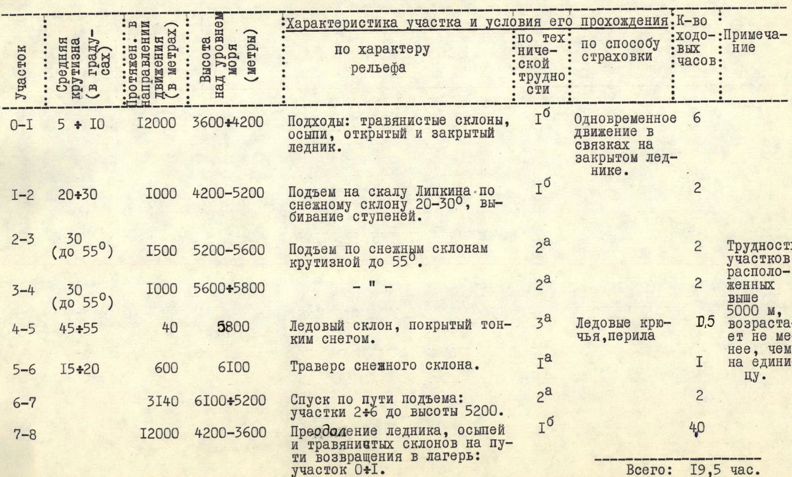
| Section | Average Steepness (in degrees) | Length and Elevation Gain (in meters) | Altitude Above Sea Level (meters) | Section Characteristics and Passage Conditions: by relief character | by technical difficulty | by insurance method | Number of Travel Hours | Notes |
|---|---|---|---|---|---|---|---|---|
| R0–R1 | 5–10° | 12000 m | 3600–4200 m | Approaches: grassy slopes, talus, open and closed glacier. | 1Б | Simultaneous movement in ropes on closed glacier | 6 ч | |
| R1–R2 | 20–30° | 1000 m | 4200–5200 м | Ascent to Lipkin Rock via a snowy slope 20–30°, step cutting. | 1Б | 2 ч | ||
| R2–R3 | 30–55° | 1500 м | 5200–5600 м | Ascent on snowy slopes up to 55° steep. | 2А | 2 ч | Difficulty of sections above 5000 m increases by at least one unit. | |
| R3–R4 | 30–55° | 1000 м | 5600–5800 м | — | 2А | 2 ч | ||
| R4–R5 | 45–55° | 40 м | 5800 м | Ice slope covered with thin snow. | 3А | Ice screws, ropes | 1,5 ч | Above 5000 m, difficulty increases by at least one unit. |
| R5–R6 | 15–20° | 600 м | 6100 м | Traverse of snowy slope. | 1А | 2 ч | ||
| R6–R7 | 3140 м | 6100–5200 м | Descent via ascent route: sections R2–R6 to 5200 m. | 2А | 2 ч | |||
| R7–R8 | 12000 м | 4200–3600 м | Crossing glacier, talus, and grassy slopes on return to camp: section R0–R1. | 1Б | 40 ч | |||
| Total: | 19,5 ч |