
4.2.26
4.2. Pamir, Vanch Range, Peak Khrustalny, 5231 m, North Face
Alpinism Club "Donbass"
| Designation | Rank | Club | |
|---|---|---|---|
| 1. | BONDARETS Stanislav Afanasievich | Candidate for Master of Sports | Burevestnik |
| 2. | FELD'MAN Gennadiy L'vovich | 1st sports rank | Burevestnik |
| 3. | MIROSHNICHENKO Konstantin Vasil'evich | 1st sports rank | Avangard |
| 4. | MARTYNENKO Sergey Ivanovich | 1st sports rank | Avangard |
| 5. | MESHCHERYAKOV Aleksandr Sergeevich | 1st sports rank | Avangard |
Donetsk 1976 year
Brief Geographical Description of the Climbing Area
Peak Khrustalny is located in the northern spur of the eastern part of the Vanch Range (see diagram). Glaciers flowing from this spur, such as Skrytnый, Mramorny, and Visyachiy, are left tributaries of the Abdukagor Glacier.
On the other side of this spur flows the Pravыy Dustyroz Glacier. At the confluence of the Medvezhiy Glacier, the Abdukagor River, and the Dustyroz River, there is the settlement of Dal'niy, which serves as a base for geologists.
Peak Khrustalny owes its name to the mineral mined here. The peak dominates the camp and is only visible to the left and further away from Abdukagor are the massifs: Peak 26 Baku Commissars, Peak Revolyutsii, and Peak Parizhskoy Kommunы.
From the geologists' settlement, it takes 1 hour of walking downstream along the Abdukagor River for the Vysotnik mountaineering camp to set up its tents for the third consecutive year.
The camp is located at the confluence of the Abdukagor River and the Geographical Society Glacier, where the famous Vanch Valley begins.
The camp is gaining increasing popularity among mountaineers due to its proximity to such beautiful mountains as Peak Kommunisticheskoi Akademii, Peak Garmo, Peak Revolyutsii, Peak Bakinskikh Komissarov, and others. But there are even more unnamed peaks here, which attracts mountaineers.
In the 1975-1976 season, ascents were made to Peak Kom. Akademii, Peak 26 Baku Commissars, and Peak Revolyutsii from the Vysotnik alpine camp.
The weather in this region of Pamir is quite changeable. The climate is harsh. The rocks are destroyed, and there are many loose stones.
Usually, around August 20th, the weather worsens.
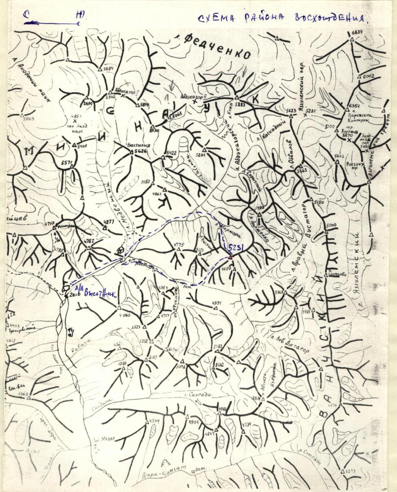
▲ 5231 — ON THE DIAGRAM. Peak Khrustalny
Approach to the Route
To the geologists' settlement "Dal'niy" by road. Before entering the settlement, turn right and cross the Abdukagor River by bridge, and then cross the Dustyroz River by fording. Along the serpentine road passing along the left (orographic) side of the Dustyroz gorge, ascend to the Dustyroz gorge. Continue along this road until the first left (orographic) tributary flows into the Dustyroz River. At this point, the road approaches the river closely, and on the opposite bank, the lower part of a huge couloir is visible, separating peaks 5025 and 5231. From the geologists' settlement, it takes 3-4 hours of walking. Cross the Dustyroz River via a huge snow-ice bridge and ascend to the couloir via scree. Along the icy, sometimes rocky, couloir floor with a slope of 20-30°, ascend to the point where the main gully of the north face of peak 5231 meets the couloir. 30-50 meters higher up the couloir, on its left (in the direction of travel) side, there are possible (not very comfortable) bivouacs. From the bivouacs, another 150-180 meters up the couloir. 60-80 meters above a large rock protruding from the couloir floor is the start of the route. From the Dustyroz River, it takes 2.5-3.5 hours. After 8:00-9:00 am, it is dangerous to pass under the main gully of the wall! Rockfall continues until late evening (22:00-23:00).
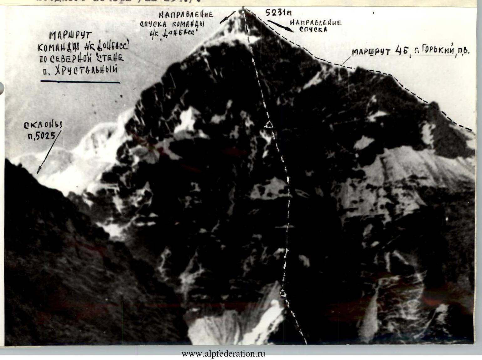
TABLE (Appendix II)
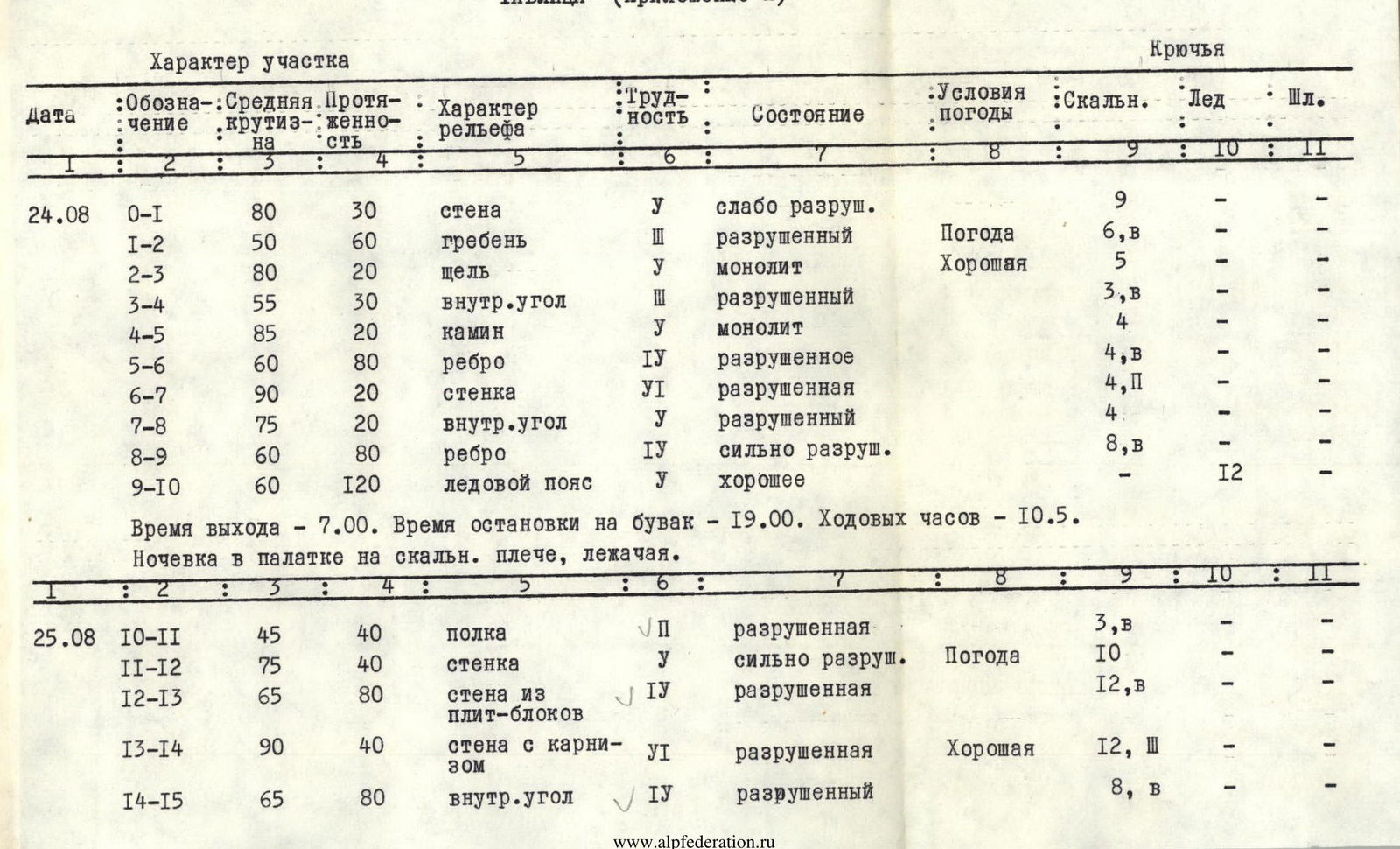
| Date | Designation | Average Slope | Length | Character of Relief | Difficulty | Condition | Weather Conditions | Pitons: Rock | Pitons: Ice | Pitons: Bolts |
|---|---|---|---|---|---|---|---|---|---|---|
| 24.08 | R0–R1 | 80 | 30 | wall | V | weakly destroyed | 9 | – | – | |
| R1–R2 | 50 | 60 | ridge | III | destroyed | Good Weather | 6, B | – | – | |
| R2–R3 | 80 | 20 | crack | V | monolith | 5 | – | – | ||
| R3–R4 | 55 | 30 | internal angle | III | destroyed | 3, B | – | – | ||
| R4–R5 | 85 | 20 | chimney | V | monolith | 4 | – | – | ||
| R5–R6 | 60 | 80 | edge | IV | destroyed | 4, B | – | – | ||
| R6–R7 | 90 | 20 | wall | VI | destroyed | 4, P | – | – | ||
| R7–R8 | 75 | 20 | internal angle | V | destroyed | 4 | – | – | ||
| R8–R9 | 60 | 80 | edge | IV | heavily destroyed | 8, B | – | – | ||
| R9–R10 | 60 | 120 | ice belt | V | good | – | 12 | – | ||
| R10–R11 | 45 | 40 | ledge | V | destroyed | 3, B | – | – | ||
| 25.08 | R11–R12 | 75 | 40 | wall | V | heavily destroyed | Weather | 10 | – | – |
| R12–R13 | 65 | 80 | wall of slabs-blocks | IV | destroyed | 12, B | – | – | ||
| R13–R14 | 90 | 40 | wall with overhang | VI | destroyed | Good | 12, Sh | – | – | |
| R14–R15 | 65 | 80 | internal angle | IV | destroyed | 8, B | – | – | ||
| R15–R16 | 75 | 40 | edge | V | destroyed | 8 | – | – | ||
| R16–R17 | 90 | 40 | wall | VI | heavily destroyed | 10, II | – | – | ||
| R17–R18 | 75 | 80 | buttress | V | destroyed | 16 | – | – | ||
| R18–R19 | 60 | 40 | ridge | III | monolith | 6 | – | – | ||
| R19–R20 | 90 | 40 | wall | V | weakly destroyed | 9, II | – | – | ||
| 26.08 | R20–R21 | 50 | 40 | ridge | III | monolith | Good Weather | 5, B | – | – |
| R21–R22 | 100 | 40 | wall with overhang | VI | monolith | II, VII | – | – | ||
| R22–R23 | 70 | 40 | slabs | V | monolith | 8 | – | – | ||
| R23–R24 | 65 | 80 | rock blocks | IV | weakly destroyed | 10, B | – | – | ||
| R24–R25 | 80 | 80 | internal angle | V | weakly destroyed | 18 | – | – | ||
| R25–R26 | 80 | 40 | chimney | V | monolith | 10 | – | – | ||
| R26–R27 | 90 | 40 | internal angle | V | weakly destroyed | II | – | – | ||
| R27–R28 | – | II | ledge | II | weakly destroyed | 2 | – | – | ||
| 27.08 | R28–R29 | 75 | 80 | wall | V | weakly destroyed | Weather | 21 | – | – |
| R29–R30 | 60 | 100 | ice wall | V | good | Good | – | II, III | – | |
| R30–R31 | 40 | 200 | ice ridge | IV | good | – | 15 | – | ||
| R31–R32 | 60 | 240 | rock ridge | IV | monolith | 25, B | – | – |
Departure time — 7:00. Time of stopping for a bivouac — 19:00. Total climbing hours — 10.5. Bivouac in a tent on a rocky shoulder, lying down.
Departure time — 7:00. Time of stopping for a bivouac — 17:30. Total climbing hours — 10.5. Bivouac lying down in a tent at the boundary of rocks and ice (2nd ice belt), on a small ridge.
Departure time — 6:30. Time of stopping for a bivouac — 20:30. Total climbing hours — 12.5. Bivouac sitting, without a tent, on ledges.

Departure time — 8:00. Time of stopping for a bivouac — 20:00. Total climbing hours to the summit — 9. Bivouac in a tent on descent, lying down.
Team Captain (BONDARETS S.A.)
Team Coach (SIVTSOV B.G.)
Explanations for the Table
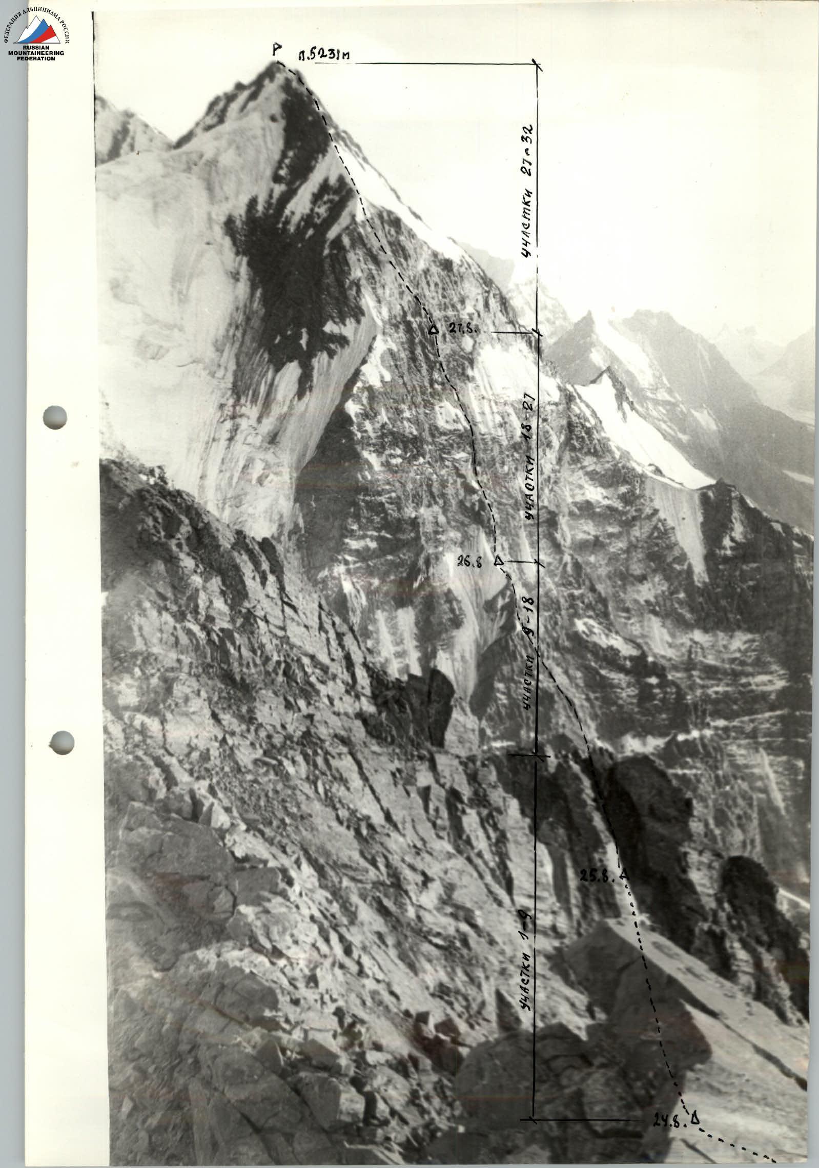
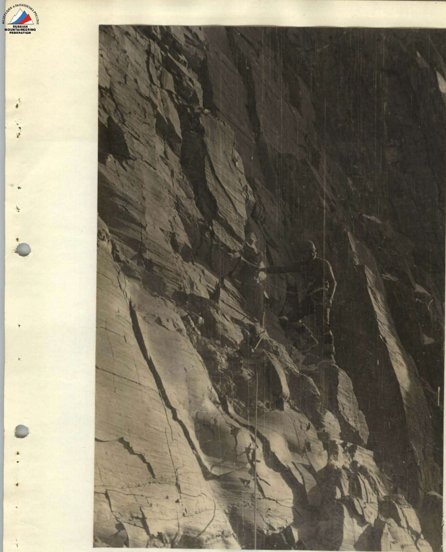
R0–R1: right — up to the left side of the couloir R1–R2: left — up along the left side of the couloir to a crack. The couloir itself is prone to rockfall R2–R3: up a wide crack, wedging into it R3–R4: approach to R4: left — up R4–R5: up a chimney onto an edge R5–R6: on a site at the beginning of the edge — 1st control point. From it left — up along the left side of the edge to the left part of the vertical wall of the edge ascent R6–R7: bypass on the left of the edge ascent R7–R8: R8–R9: along the edge onto the ice belt passing under the overhanging wall R9–R10: traverse of the ice belt to the right along a rocky shoulder with a site where the central buttress of the north face begins. On the site is a bivouac and 2nd control point. R10–R11: along a ledge left — up begins a bypass of the buttress ascent R11–R12: straight — up R12–R13: straight — up R13–R14: right — up to the base of the internal angle R14–R15: right — up, onto the buttress R15–R16: up the destroyed rocks on the right (approach) side of the buttress R16–R17: to the ice exits on the left along the route. Here, on the flattening of the buttress, is a bivouac R17–R18: R18–R19: processed from the bivouac. Up and slightly right under the overhanging ascent. R19–R20: processed. Bypass of the overhang to the right and exit onto the buttress. R20–R21: straight up under the wall with an overhang R21–R22: up and right along the wall to a site R22–R23: up and right onto the left side of the couloir R23–R24: along the left side of the couloir (rockfall!) R24–R25: straight up; in the middle of the section — a narrow ledge, at the end — also. R25–R26: straight up onto a ledge R26–R27: from the left part of the ledge straight up and after 40 meters exit from the angle to the left onto a ledge R27–R28: left along the ledge to the sitting bivouac site R28–R29: from the right ledge up and slightly right R29–R30: straight up R30–R31: straight up R31–R32: up along the ridge; all obstacles are bypassed.
To the USSR Alpinism Federation, Classification Commission
Regarding the passage of the north face of Peak 5231 Central Pamir.
From August 22 to 28, 1976, a team of climbers from the "Donbass" club consisting of: BONDARETS S.A. — Candidate for Master of Sports, leader; FELD'MAN G.L. — 1st sports rank; MIROSHNICHENKO K.V. — 1st sports rank; MARTYNENKO S.I. — 1st sports rank; MESHCHERYAKOV A.S. — 1st sports rank, completed a first ascent of the north face of Peak 5231 m (conditional name Peak Khrustalny).
Peak 5231 dominates the part of the Dustyroz and Abdukagor gorges visible from the Vysotnik base camp. It faces the camp with its north face. The upper part of the wall and the group's path, passing through its center, are clearly visible from the camp. The entire wall has been repeatedly observed by Vysotnik alpine camp climbers who traversed Peaks 4975-5025. Despite its proximity to the base and the peak's attractiveness, it was only conquered on August 25, 1976. The first ascenders (a group from the Gorky "Zenit") ascended via the western ridge (approximately 4B category of difficulty). The Donetsk climbers' ascent was the second ascent of Peak 5231 and the first wall ascent.
Observations of the wall and the Donetsk climbers' ascent suggest that the north face route corresponds to the 5B category of difficulty in terms of length and slope.
The wall is quite heavily destroyed, especially in the lower part. The group's path is one of the few non-rockfall-prone options for ascending the wall. Due to the relatively short approach, reliable radio communication with the base, and the presence of a simple descent (found by the Donetsk group), the route may become popular among Vysotnik alpine camp climbers.
Route advantages:
- Short approach
- Reliable radio communication with the base
- Presence of a simple descent
Head of KSP Vanch Region, Master of Sports of the USSR Ovcharov G.M.
Recommendations for Subsequent Climbers
- Approach the route via the couloir early in the morning to pass under the main gully of the wall no later than 8:00-9:00 am.
- Do not deviate from the route to the right. Rockfall hazard!
- Have tricams or crampons for each climber.
- Have a rich set of long and thick rock pitons. Wedges and channel pitons work well.
- Have at least 3 ropes, even if they are 12 mm. A rope can be cut by a rock.
- Do not stand under each other: a rock can fall even from a slight shock upon a weak impact on the rock with a hammer.
- Maximally unload the first climber even on несложных участков: holds are often unreliable.
- Do not start the route immediately after bad weather.
- Descend via the eastern ridge; in case of descent to the west — spend the night near the summit and begin the descent in the morning.
Description of Descent into the Abdukagor Gorge
From the summit tur, back (to the north) along the ridge and, not reaching the eastern ridge, right — down (in the direction of travel 50–60 m). Crossing right-down the ice-snow tongue, descend to the eastern ridge. Along the ice-snow ridge down to the 1st scree couloir going right-down. Along the couloir to the Mramorny Glacier. Along the left edge (in the direction of travel) of the glacier, bypassing the icefall on the left, to the "ram's foreheads". Two steps of "ram's foreheads" are passed with rappels (25–35 m), the scree between them — on foot. Further descent — near the left (in the direction of travel) bank of the stream flowing from under the Mramorny Glacier, to the "ram's foreheads". From the "ram's foreheads" to the Abdukagor Glacier, 2 rappels of 25–35 m. Further along the left (orographic) bank of the glacier, along the river, down to the bridge over the Abdukagor River. After crossing to the right orographic bank, down the road. The descent from the summit to the Abdukagor Glacier takes 4 hours.
Comments
Sign in to leave a comment