
Ascent Log
- CATEGORY: technically challenging ascents.
- REGION: Central Pamir, upper reaches of the Vanch River.
- ROUTE: first ascent of Maly Ravak peak via the northern counterfort, ridge.
- Ascent description: height difference: 4600–3800 = 800 m; average steepness 45°–60°; length of difficult sections — 400 m, including very difficult — 55 m.
- Pitons hammered: 24 (rock).
- Number of travel hours: 14.
- Team name: team of LGS DSO “Spartak”.
- Team composition:
- Baybara Viktor Savelyevich — team leader, 1st sports category.
- Presnova Valentina Alexandrovna — 1st sports category.
- Kopytov Valentin Pavlovich — 1st sports category.
- Kolchin Alexander Alexandrovich — Master of Sports of the USSR.
- Team coach: Master of Sports of the USSR Kolchin A. A.
- Date of ascent — August 11, 1975.
| Section | Average steepness | Length in meters | Section characteristics and passage conditions | Terrain nature | Difficulty category | Passage method and belay | Weather conditions | Travel time | Pitons (rock) |
|---|---|---|---|---|---|---|---|---|---|
| R1 | 45° | 300 | Snow-ice slope of the cone-shaped ledge under the summit | easy | 2 | Simultaneous movement in crampons | 1 h | ||
| R2 | 45° | 20 | Rock slab with cracks | medium difficulty | 3 | Ropes | 30 min | 1 | |
| R3 | 85° | 65 | Steep rock wall | Very difficult | 5 | Ropes | GOOD | 2 h | 8 |
| R4 | 45° | 300 | Destroyed rock ridge | Easy | 2 | Simultaneous. Belay via outcrops and ridge bends | GOOD | 1 h 30 min | 1 |
| R5 | 45° | 70 | Traverse up-right along rock shelves | Easy | 2 | Simultaneous | GOOD | 1 h | |
| R6 | 50° | 30 | Traversing the rock couloir to the right towards the summit ridge | difficult | 4 | Alternating movement, piton belay | GOOD | 1 h | 5 |
| R7 | 60° | 300 | Rock counterfort, vaguely defined | Medium difficulty | 3 | Alternating movement. Belay via outcrops and pitons | GOOD | 2 h | 10 |
| Total for the entire route | At the summit — 14:00, travel — 15:00. Total — 7000 m | 24 |
Geographical Description
Maly Ravak peak is the second eastern summit of the Ravak horseshoe, located in the upper reaches of the Vanch River in the Western Pamir. A more detailed geographical description of the horseshoe is provided in the reports on ascents to Ravak (5232 m) and Shaugada (5137 m) peaks. The summit is not marked on maps, likely because it is not visible from either the Vanch River valley or the Abduqagor valley. It is clearly visible from the Ravak glacier (see photo). The summit has approximately the same height as Kulizog peak (4665 m) — the first eastern summit of the Ravak horseshoe. To the southwest of Maly Ravak peak is Peak 5201 — the first five-thousander of the Ravak horseshoe. Maly Ravak is separated from it by a ridge depression at approximately 4400 m. A heavily jagged ridge leads to Kulizog peak, with depressions down to 4300 m. Between the long eastern ridge of Peak 5201, Maly Ravak peak, and the eastern ridge of Kulizog peak lies an unnamed glacier, which we propose to name the Kulizog glacier. The upper cirque of this glacier is located at approximately 4250 m. From this cirque, Maly Ravak peak is more accessible, so it is logical to descend from the summit to this glacier. In terms of mountaineering, the northern side of Maly Ravak peak does not resemble the northern walls of the neighboring five-thousanders of the horseshoe. It consists of clean, snow-free, and ice-free rocks. This is likely due to the lower height of the summit.
Description of the Ascent Route to Maly Ravak Peak via the Northern Counterfort
1. Approach
From the base camp in the Koy-Zog tract, follow the road down to the cone-shaped ledge of the Ravak River and then along the Ravak River canyon to the glacier tongue. The glacier tongue can be bypassed on the right, following the talus slopes, and ascend to the lateral moraine forward of the glacier bend. At the bend, there are very convenient Ravak camping sites on the moraine. From them, crossing the glacier to the start of the route takes about an hour. It is also possible to camp on the talus slopes directly below the start of the route. In this case, near the glacier tongue, one should ascend to the left moraine and move along it to the camping site, which can be set up on the talus slopes at an altitude of ~3700 m, about 200 m before the snow slope that begins the route. If there is no continuous snow bridge in the Ravak River canyon, it is possible to exit onto a shelf on the right (piton belay) at approximately 40–60 m above the canyon floor at the beginning of the canyon. It is also possible to reach the Ravak glacier through the northern grassy shoulder of Kulizog peak.
2. Ascent
From the upper end of the talus slopes (altitude approximately 3800 m), ascend the snow-ice slope, bypassing the base of the northern counterfort of Maly Ravak peak on the right (section R1, 300 m, 1 h, crampons). The landmark is the right rock outcrop of the counterfort. This outcrop is bypassed on the right. Immediately behind it (~20 m), on the rocks, there is an inclined shelf under overhanging rocks. The avalanche chute from the snow-ice slope between Maly Ravak and Peak 5201 leads directly to the base of the counterfort. This chute collects all the rocks from the wall of Peak 5201. Therefore, bypassing the base of the counterfort to the shelf, where the rock route begins, should be done before 8:00 (in August) before rockfall begins. From the shelf, move left-up 15 m to a new shelf and then 40 m straight up, very difficult rocks, to exit onto the counterfort shoulder (85°, 8 pitons). Belay is via pitons. To the right remain strongly overhanging rocks, to the left — a monolithic ridge of the counterfort. At the beginning of the section, movement is along small inclined holds, and at the end, a crack appears, slightly facilitating climbing on the last 5 meters. The rocks are sedimentary but very solid (although there are some loose rocks). Pitons hold well. Further movement along the counterfort is ~200 m (R3): the ridge is wide, not clearly defined.
The rocks are easy, with many loose stones. Gradually, the ridge becomes sharper and steeper. Two gendarmes are bypassed on the right. Then, before a large steep ascent of the ridge — a transition to a couloir with an exit to the neighboring counterfort (R5, 30 m, difficult rocks, 5 pitons). Further movement is straight up along the vague counterfort to the summit (R5). Solid granite rocks, steep (60° and steeper, 300 m), but with many holds. Pleasant climbing. Belay via outcrops and pitons (10 pitons). The route is climbed in rock shoes (Vibram or galoshes).
3. Descent
To descend from the summit, first traverse the heavily jagged rock ridge (150–200 m) leading to Kulizog peak. Gendarmes are taken head-on or bypassed on the right. Before a large descent of the ridge (or 30 m before it) — descend into the right rock couloir and along it to the glacier flowing east (Kulizog glacier), from the cirque formed by Kulizog, Maly Ravak, and Peak 5201. Then along the glacier, along the ridge leading to Kulizog peak — ascend to the second saddle on the ridge. From the saddle, descend via rappelling (3 descents of 40 m) along the couloir to the north and then along simple rocks and talus slopes to the Ravak glacier, where the ascent began. With a known direct path from the Kulizog glacier to the Abduqagor gorge, it is likely much faster to return to the base camp via this route.
Route Assessment
The route passes along dry rocks (except for the snow-ice beginning, requiring crampons), allowing it to be climbed entirely in rubber boots (Vibram or galoshes). It should be compared with similar routes available in the Fann Mountains. It is noticeably longer — both in overall length and in the length of difficult sections — than Ruzevat 4B or Alaudin 4B. There are no sections of such difficulty as the first counterfort wall in any known "fourth category" route. This wall is apparently impassable in free climbing in tricams.
The group requests to approve the route as 4B category of difficulty. The Route Commission of the “Vysochnik” alpine camp (chairman D. E. Kheysin) agreed with this assessment.
Team leader: Baybara V. S. Coach: A. A. Kolchin
Route Map

△ — base camp △ — Ravak camping sites — — — — route of the giburm group
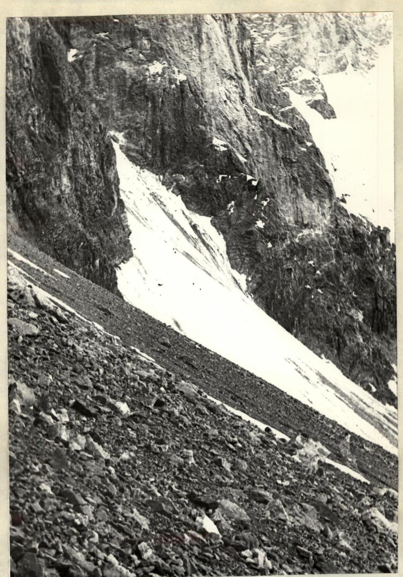
Snow-ice slope of the cone-shaped ledge under Maly Ravak peak.

Route Map-Scheme
Area of the upper reaches of the Vanch River. — ascent route △ △ camping sites
Comments
Sign in to leave a comment