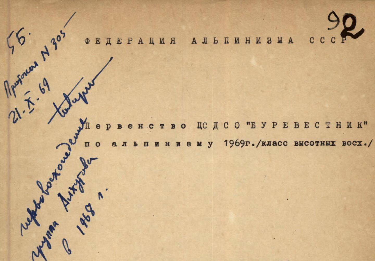
ALPINISM FEDERATION OF THE USSR
CS DSO "Burevestnik" Championship in Alpinism 1969, High-Altitude Climbing Class
Peak Pravda (6500 m) via the Western Counterfort (approx. 5B cat. diff.)
TEAM OF THE LOCAL COMMITTEE OF THE CHELYABINSK POLYTECHNIC INSTITUTE.
Chelyabinsk, 1969
Peak Pravda (6400 m) is located in the center of the northwestern Pamir in the Akademiya Nauk Range, on the territory of the Tajik SSR.
This region is the most elevated part of the Pamir. Here, particularly favorable conditions are created for the formation and accumulation of ice, which in the form of glaciers slides down the slopes of the ridges and peaks, filling the valleys (Fedchenko, Fortambek, Garmo, etc.). The snow line in this area is approximately at an altitude of 4000–4500 m. The climate in the region is sharply continental with sharp temperature fluctuations from winter to summer, from day to night.
The high altitude and considerable technical complexity make Peak Pravda an excellent mountain in alpinist terms, and the ascent via the most difficult route—the western counterfort from the Belyaev Glacier—represents significant sporting interest.
In 1968, a group of climbers ascended this route:
- Alkhutov N.A. — leader
- Karlov G.S.
- Roschin I.N.
- Shataev V.N.
and evaluated it as a 5B cat. diff. route.
In 1969, we planned this route for participation in the CS DSO "Burevestnik" Championship in Alpinism in the high-altitude climbing class.
Team composition:
- Bedov S.N. — leader, 1st sports category, 1937, "Burevestnik," Chelyabinsk;
- Samokhvalov V.V. — Master of Sports, 1937, "Burevestnik," Chelyabinsk;
- Rung G.R. — Candidate for Master of Sports, 1938, "Burevestnik," Chelyabinsk;
- Grafov V.N. — Candidate for Master of Sports, 1937, "Burevestnik," Chelyabinsk;
Before ascending Peak Pravda, the group members conducted a training ascent on Peak Olga via a 3A cat. diff. route.
July 18 — The group left the base camp located on the Belyaev Glacier (Georgian bivouac, 4700 m) towards the western slopes of Peak Pravda. After traversing the heavily snow-covered closed Belyaev Glacier, the group approached the bergschrund crossing the slope of Peak Pravda between the western (left) and central counterforts of the peak at 7:00 via a gentle snow slope (R1). Putting on crampons and crossing the bergschrund via a sturdy snow bridge, they began ascending directly up the steep snow-ice slope (R2). The slope's steepness quickly increased to 40°. The heavy snow cover in the area this year allowed for reliable ice axe belays in many places on this slope. On the other hand, the deep snow cover made the ascent challenging as it required a lot of effort to kick steps. Where there was less snow, it had to be cleared to hammer in ice screws. The ascent proceeded towards a not clearly defined snow-rock ridge starting above the first rock wall. 350 meters of the snow slope led them to the rocks (R3). Although the steepness did not exceed 55–60°, the ascent on the rocks was quite difficult due to the ice coating. 80 meters of rock climbing led them to a snow-ice ridge (R4). There were small rock outcrops on the ridge where they set up belay points. In some places, belays were organized using ice screws. Movement continued in teams. Crampons significantly facilitated progress. After traversing 150 meters along the ridge, they approached rocks of moderate difficulty (R5) leading to the base of the black rock wall. Another 2 hours and 30 minutes of climbing led them to the traces of the first ascenders — a neatly arranged platform for a tent.
July 19 — At 8:00, they resumed their ascent towards the summit. Traversing rightwards along a 402-meter snowfield (R6) at the base of the black wall, they ascended 40 meters up the rocks (R7). From here, two paths led upwards: left and upwards — monolithic rocks of great steepness, and straight up — a steep ice slope with rare rock outcrops (R8). They chose the second option. Progress was slow, moving from outcrop to outcrop on the front points of their crampons, frequently hammering in pitons. Additionally, they constantly monitored the upper rocks to the left, from which rocks occasionally fell. 250 meters of the ice slope required seven hours of work. Further, 20 meters up a steep icy wall (R9) led them to rocks of moderate difficulty. They traversed 150 meters of rocks (R10), and their path was blocked by a short sheer wall. Using rock pitons as artificial aids, they ascended this wall (R11). The late hour prompted them to search for a bivouac site, but the steepness of the rock slopes suggested, at best, a seated bivouac. Searching for a suitable spot, they traversed along a narrow ledge to the right (R12), then ascended via broken rocks (R13) to a steep snow slope (R14), at the end of which a small platform was discernible. Reality exceeded their expectations: at the end of the snow slope on a detached rock, there was an excellent platform. An hour's work to prepare it for a tent was nothing compared to the comfortable rest it provided.
July 20 — They departed from their bivouac at 11:00. Ascending directly up an internal angle (R15) and leftwards up good rocks (R16), they found themselves on a sharp snow-ice ridge (R17–R19). The steepness of the ridge quickly increased, as did the steepness of the slopes forming the ridge. To the south, there was a snow slope with a steepness of up to 65–70°, and to the north, a 60-degree ice slope under a thin (up to ten centimeters) layer of snow. They moved upwards slowly (altitude around 6000 m), kicking and cutting steps. After 300 meters, rock outcrops appeared on the ridge, providing a chance to rest. The ridge ended in a steep slope with loose, crumbly snow (R20). Overcoming this 50-meter snow slope required 2 hours. The snowfield ended in dissected, gently sloping rocks (R21), leading to the plateau between Peak Kommunizma and Peak Pravda.
July 21 — At 8:30, lightly equipped and without backpacks (since they needed to return to the plateau and meet the Nadein group following their route with a one-day gap), they set out from their bivouac towards the summit. The ascent initially proceeded along a gently sloping slope with very dense snow (R22), followed by rocks with good ledges (R23). The summit was a large snow plateau. A cairn was built on rocks in the western part of the summit. Descending from the summit to the plateau via their ascent route, they marked their climb with two pots of strong tea.
The next day, after sending off the Nadein group to the summit, they began to traverse Peak Pravda. Three hours later, they met the Nadein group on the other side of the peak. On July 23, together with other groups, they began their descent via the Georgian couloir to the base camp, where they congratulated each other on their first serious ascent of the season in the evening.
The following equipment was used during the ascent:
- Main ropes 2 × 40 m — 4.5 kg
- High-altitude tent — 6.0 kg
- Rock pitons 15 pcs — 1.1 kg
- Ice pitons 10 pcs — 1.0 kg
- Steel and duralumin carabiners 12 pcs — 1.1 kg
- "Febus" primus stove with gasoline — 1.6 kg
- Gasoline — 2.5 l
- Pots 2 pcs — 0.7 kg
- First-aid kit and vitamins — 2.0 kg Total weight of equipment: 20.5 kg
The participants wore shell jackets during the ascent. All participants used ice axes/ice hammers during the ascent.
Total weight of food — 11.6 kg.
The route to Peak Pravda via the western counterfort is very logical. The altitude difference from the Belyaev Glacier is 1600 m. The route is combined, with a significant predominance of ice and snow sections.
The group spent 31.5 hours of climbing time on the route. During the ascent, they hammered in 36 rock pitons and 22 ice pitons.
The group evaluated the route as 5B cat. diff.
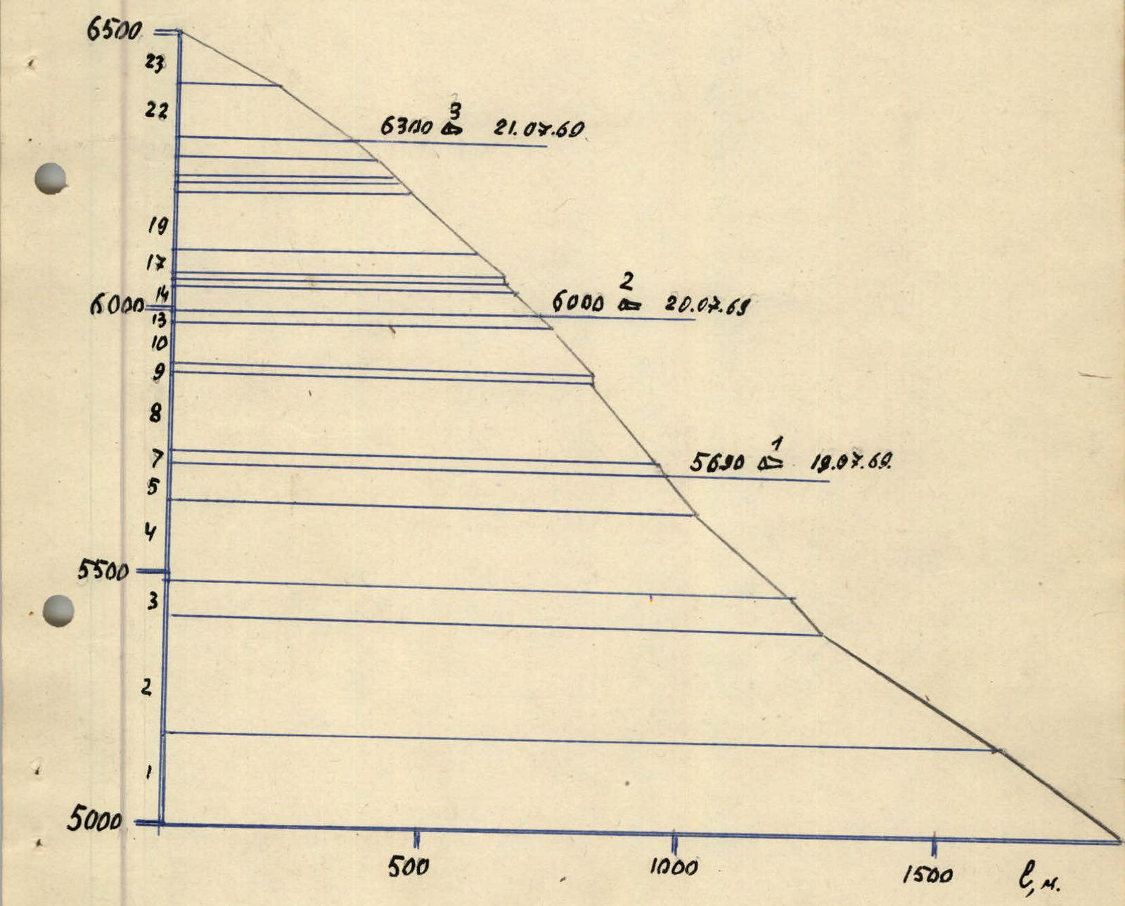
Fig. 3. Profile of the route to Peak Pravda
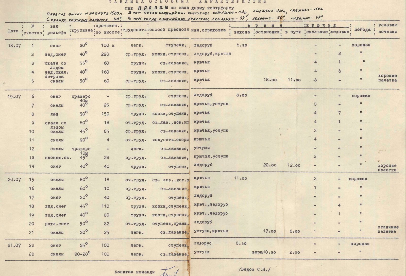
Table of Main Characteristics
Protocol
of the analysis of the ascent on Peak Pravda (6400 m) via the western counterfort (approx. 5B cat. diff.)
Location of the analysis — base camp at 4700 m on the Belyaev Glacier.
Present: participants of the ascent Bedov S.N., Samokhvalov V.V., Grafov V.N., Rung G.R.; members of the expedition Ryabukhin A.G., Gavrilov B.A., Ryazanov V.V., Nadein V.A., Rozhalskaya G.K., Sorokin S., Osipov V., Khudozhin V.M., Smirnov V., Sidorov G., Reznikov B.A., Dubikovskaya M.I., Zhirgalov V., Markin V., Greilikh P.F.
The analysis was conducted by the supervisor Ryabukhin A.G. on July 24, 1969.
Bedov S.N. — leader of the ascent. We left the base camp on July 18 at 5:05 and began our ascent towards the bergschrund by 6:30. Another half hour later, having approached the bergschrund, we roped up, put on crampons, and easily crossed the bergschrund via a snow bridge. The route is combined but predominantly snow and ice. The snow mainly lies on the ice, with a cover thickness of 20 cm, sometimes less. We traversed 11 ropes along the steep snow-ice-firn slope with alternating belays. Then, along a not clearly defined ridge with rock outcrops and rocks at the end of the path, we climbed another 9 ropes. We bivouacked on a fairly good platform of the first ascenders. The next day, we started climbing at 6:30 because the wide couloir between the western and central counterforts becomes dangerous after being exposed to sunlight. We ascended 8 ropes up an ice slope with small rock outcrops. Another 6 ropes on difficult, ice-covered rocks led us to a large detached rock with a snow overhang, where we set up our second bivouac.
We left this bivouac quite late, somewhat compensating for our early start the previous day. But there wasn't much left to reach the plateau, and this was the real reason for the late departure. 9 ropes along a snow-ice ridge, another 2 ropes on easy rocks, and we were on the plateau. The ascent from the plateau to Peak Pravda the next day took only 2 hours. We returned from the summit to the plateau again because we had to wait for the Nadein group, which was following our route with a one-day gap. We descended from the plateau via the Georgian couloir, bypassing Peak Pravda. The route was liked; it's very logical and, if you traverse the couloir in the early hours, safe. However, it's better to approach this with caution — wear helmets.
On the participants:
- Samokhvalov — a competent climber; there's much to learn from him. He didn't feel well near the 6000 m mark.
- Grafov — poorly adapted to high altitude; although it was tough for him, he participated to the best of his ability.
- Rung Garik — performed very well from start to finish. Worked competently; adapts well to high altitude.
- Grafov V.N. — The route deserves a 5B category of difficulty. There are many loose rocks on the rocks. I tried to climb within my capabilities. The leader conducted the ascent competently.
- Rung G.R. — The peak was liked. As a doctor, I'll say about the participants:
- Bedov adapts well to high altitude; felt good throughout the ascent, but still had a slight upper respiratory tract catarrh.
- Grafov seemed less trained than last year. Currently, he adapts poorly to high altitude. I can allow him to climb Peak Kommunizma under medical supervision.
- I wouldn't recommend Samokhvalov for seven-thousanders this year.
- Bedov showed himself to be a good leader and is an exemplary climber.
- Samokhvalov V.V.:
- The route is worth 5B cat. diff.
- The route was passed correctly — both in terms of time allocation and tactics.
- Bedov feels good at high altitudes.
- Technically well-prepared, restrained, and correct.
- Recommend for leadership and ascent of 6 cat. diff.
- Grafov is technically well-prepared; adapted poorly to high altitude but forced himself to overcome all difficulties.
- Rung is physically well-prepared. Tactics and technique are somewhat lacking, but with an experienced partner, can be recommended for ascent of 6 cat. diff.
I didn't feel very well myself. The group was very attentive to me. We all got a bit sunburned; the leader should have made us apply protective creams.
Resolved:
- to credit the ascent to the participants,
- to credit the leadership to Bedov.
Chairman (Ryabukhin A.G.) Secretary (Rozhalskaya G.K.)

Fig. 4. Snow ridge in the upper part of the western counterfort of Peak Pravda (R17, R18)