24
Report
On the first ascent of the route to peak Osypnoy via the north-west ridge, category 4A (approximately), accomplished by a "two-person team" from the KBVO training camp on August 12, 1979.
TABLE of the main characteristics of the ascent route
Team captain M. Sabirov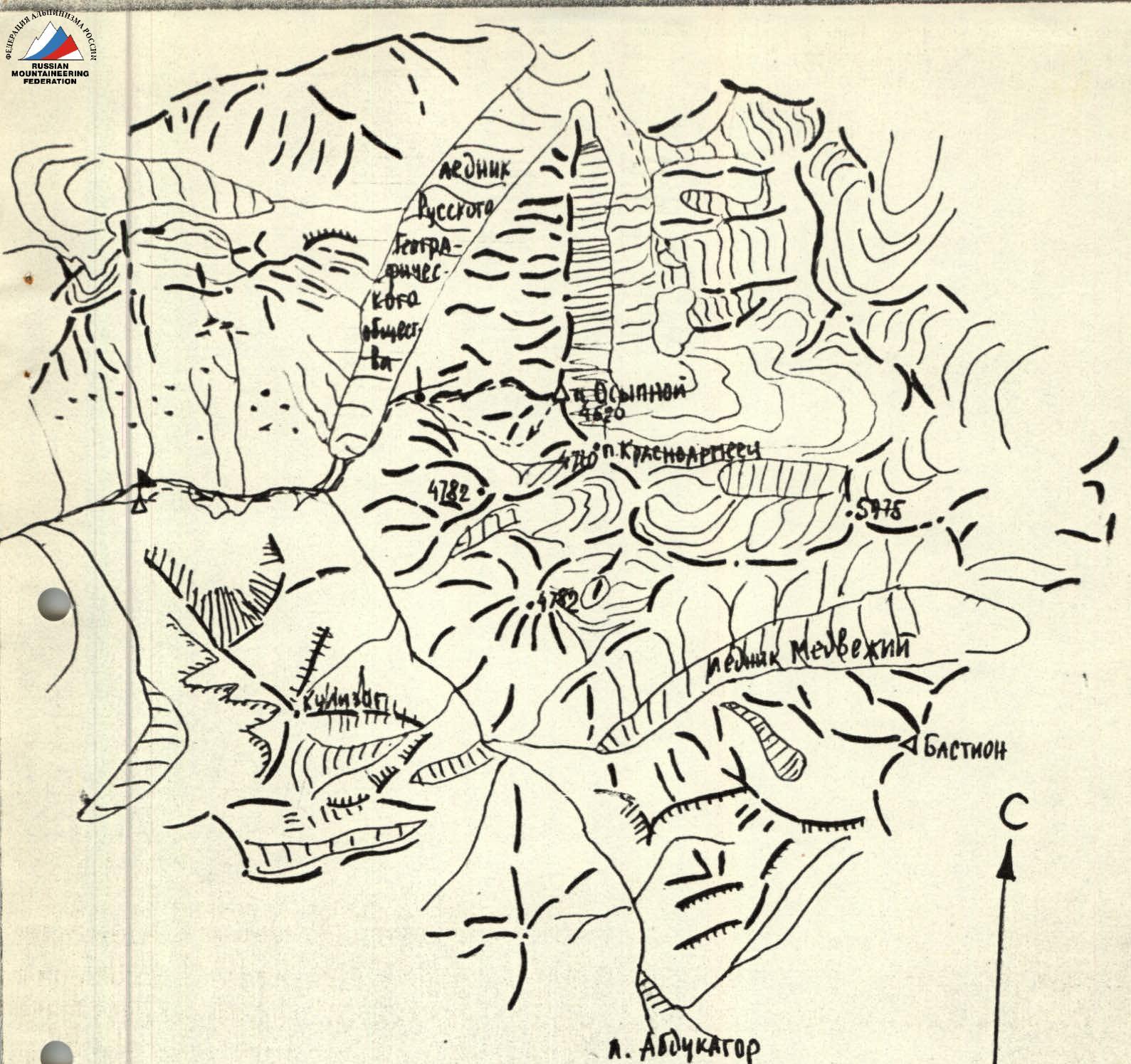
Base camp of the KBVO training camp ↓ overnight stay location — route of movement. Brief description of the approach to the route. From the base camp, located near the lakes on the bank of the Vanch River, follow the road to the bridge over the Abdukagor River (0.3 hours). Cross the bridge. To the left, a trail begins, leading to the start of the Russian Geographic Society glacier. Follow it to the lateral moraine (1 hour). Then along the moraine (cairns) to the stream flowing from the slopes of peak Osypnoy and v. Krasnoarmeets. Up the stream to a large boulder. Overnight stay (camping site).
www.alpfederation.ru
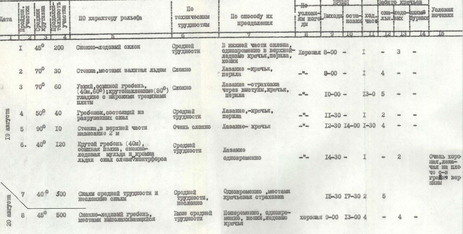
Date — August 12, 1979 | R0-R1 | 150 | 600° | snowfield covering the stream | 2 | Dense snow with inclusions of ice. | R1-R2 | 45 | 200° | smoothed rocks "lby". Severely destroyed rocks | 4 | "lby", destroyed rocks. 45–50 m, 11–11 | R2-R3 | 40 | 480° | ridge rocks | 3 | — 11–11 | R3-R4 | 50 | 100 | narrow crevice | 4 | — 11–11 | R4-R5 | 45 | 120 | destroyed ridge rocks | 3 | — 11–11, 11–11 | R5-R6 | 10–20 | 200 | scree shelves | 2–3 | — 11–11 | R6-R7 | 50–60 | 120 | snowy couloir | 4 | dense 11–11 | R7-R8 | 50 | 90 | steep "tile-like" rocks | 4 | destroyed rocks, 11–11, 11–11 | R8-R9 | ± 20 | 600 | snow-covered rocks and scree | 3 | large simultaneous — scree, snow, 11–11 | R9-R10 | 30 | 160 | rocks, snow | 4 | snow-covered alternately — 10, destroyed rocks!
 www.alpfederation.ru↗
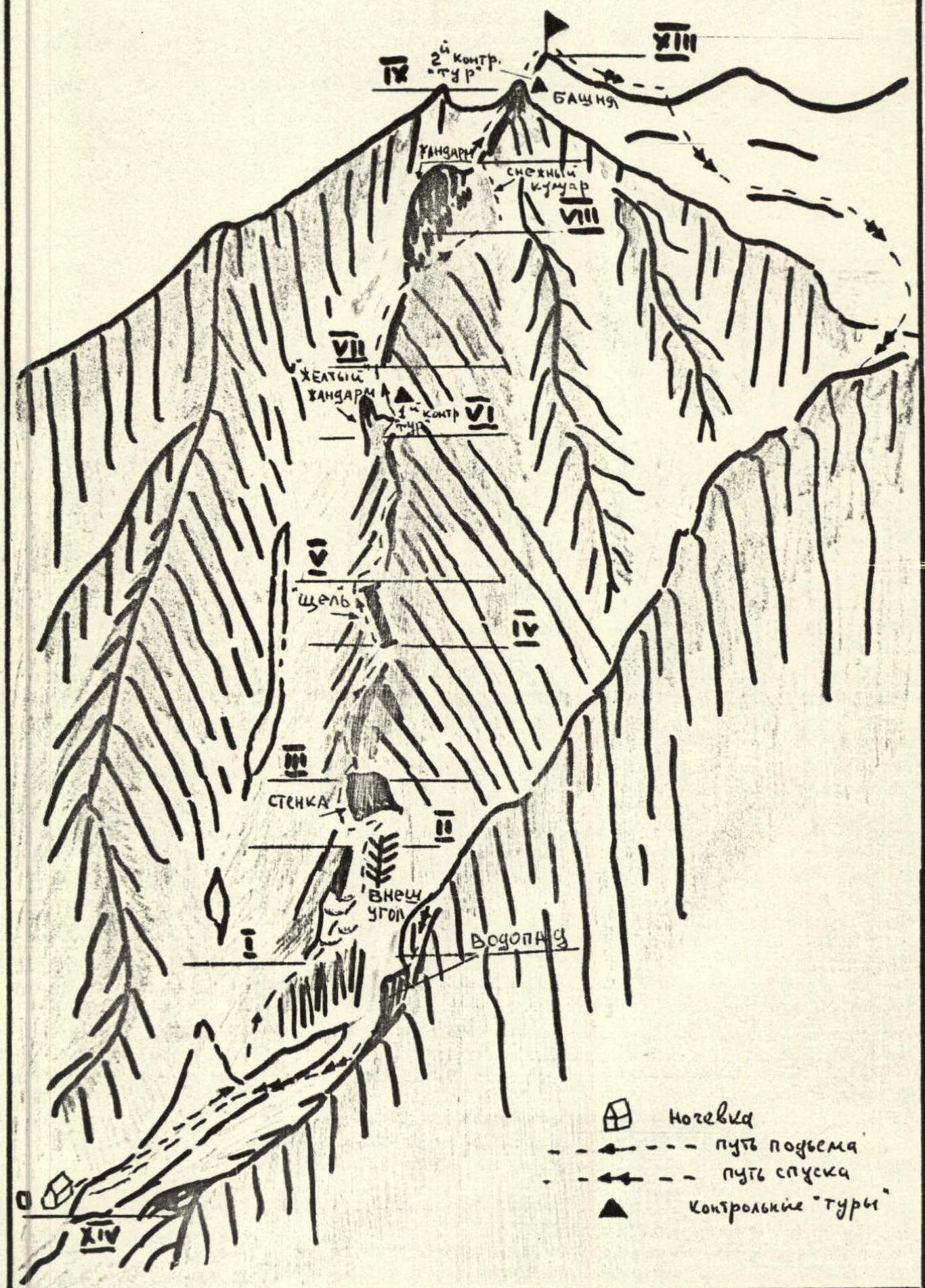
Explanation for the table. Due to the fact that the lower part of the route is prone to rockfall in the second half of the day, sections R0–R3 should be traversed in the morning.
R0–R1. Ascend the gentle snowfield (600 m) to its fork. To the right, the characteristic noise of a waterfall is audible, leading to the right snowfield. Ascend between the snowfields upwards to the left. Landmark "sheep's foreheads".
R1–R2. Severely smoothed rocks ("sheep's foreheads") alternate with destroyed rocks. Piton belay. Proceed along the right-hand side. Exit to an external corner.
R2–R3. Up the corner to the left, exit to the wall. Piton belay. Traverse to the left upwards. Exit to the counterfort ridge.
R3–R4. Along the severely destroyed rocks of the pronounced counterfort ridge to the left and upwards to a narrow crevice. To the right, two lateral counterforts are visible, leading to the tower and separated by rockfall-prone couloirs. To the left: spurs of the couloir leading to a narrow snowfield.
R4–R5. Through the crevice to the left and upwards. Traverse the crevice with caution. Pitons. "Plugs" are encountered in the crevice.
R5–R6. From the crevice to the right and upwards to a characteristic sharp "gendarme". The "gendarme" is bypassed on the right along the shelves. Exit to the ridge. 1st control cairn!
R6–R7. From the cairn along the sharp horizontal section of the ridge to the "gendarme" in the morning. Be cautious — dissected rocks.
R7–R8. Along the scree shelves, bypass the "gendarme Utug" on the right. Exit to a steep snowy couloir between the "gendarme" and the tower.
R8–R9. Up the snowy couloir to the left and upwards. Belay via rock pitons in the couloir wall.
R9–R10. From the snowy col between the "gendarme Utug" and the tower to the right and upwards along steep tile-like rocks to the tower summit. 2nd control cairn. To the right of the control cairn, the entire cirque of the Krasnoarmeets peak and Osypnoy peak glacier is visible.
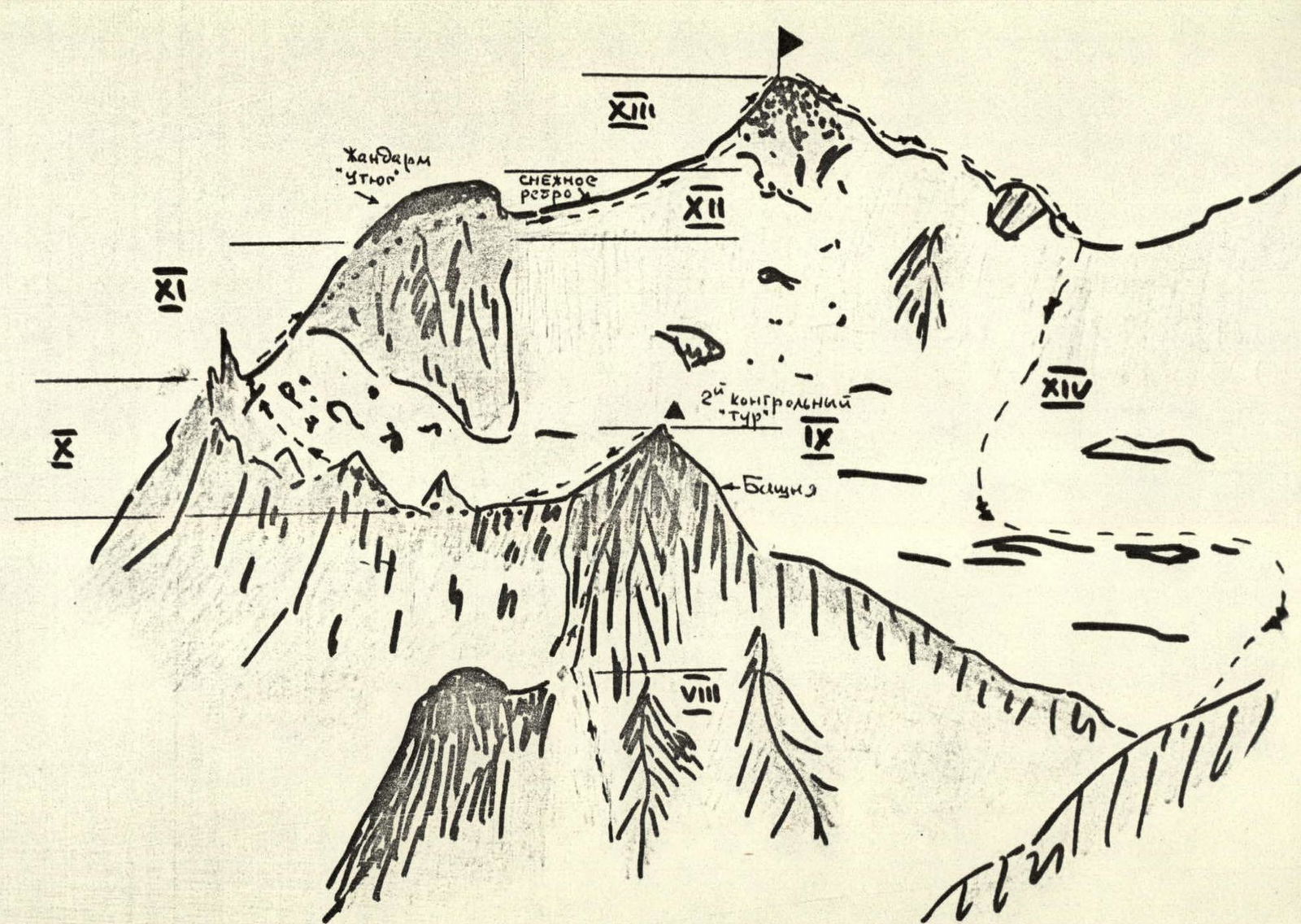
R10–R11. From the 2nd control cairn to the left and downwards to the snowy fields of the cirque's upper reaches and along them upwards to the left and then along the snow-covered large scree, exit to the col. To the left of the col, a characteristic sharp gendarme — "finger".
R11–R12. From the col to the right and upwards along severely destroyed snow-covered rocks. Then along the snow on the left side, bypassing the pre-summit gendarme. Exit to the snowy ridge. Caution! Cornices! Snow drifts!
R12–R13. Along the snowy ridge. Almost horizontal section. Stay on the right-hand side. To the left (north side), snow drifts.
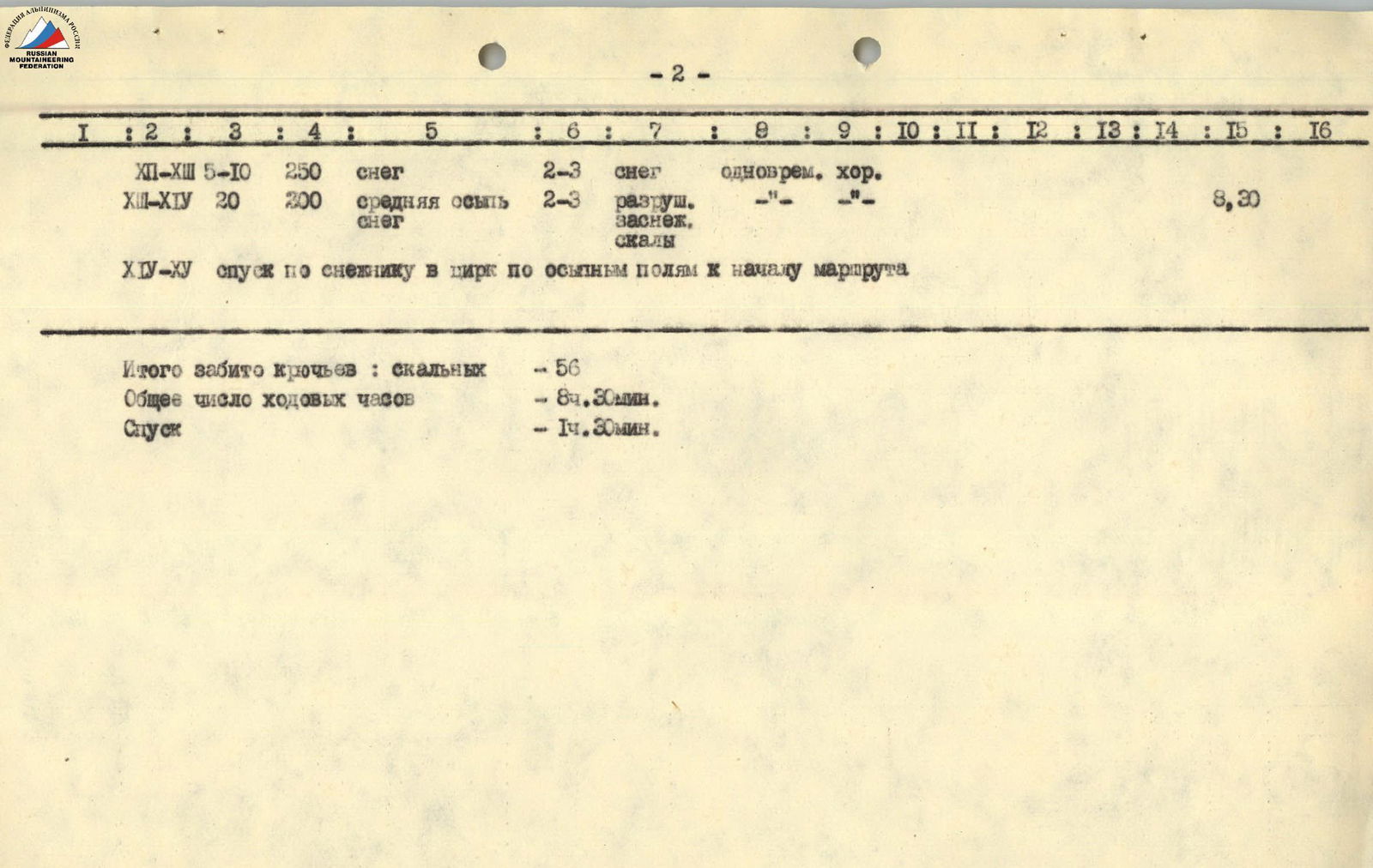
R13–R14. The snowy ridge transitions into a snowy slope, covered with medium scree, leading to the summit. 10–15 minutes to the summit.
R14–R15. Descent towards v. Krasnoarmeets. To the col — 10 minutes. Then to the right and downwards along the scree and snowfield of the v. Krasnoarmeets and p. Osypnoy cirque — 15 minutes. From the cirque, following the stream, back to the start of the route (about 1 hour). Attention! The waterfall is bypassed on the left, transitioning to grassy slopes.
www.alpfederation.ru↗
Explanation for the table. Due to the fact that the lower part of the route is prone to rockfall in the second half of the day, sections R0–R3 should be traversed in the morning.
R0–R1. Ascend the gentle snowfield (600 m) to its fork. To the right, the characteristic noise of a waterfall is audible, leading to the right snowfield. Ascend between the snowfields upwards to the left. Landmark "sheep's foreheads".
R1–R2. Severely smoothed rocks ("sheep's foreheads") alternate with destroyed rocks. Piton belay. Proceed along the right-hand side. Exit to an external corner.
R2–R3. Up the corner to the left, exit to the wall. Piton belay. Traverse to the left upwards. Exit to the counterfort ridge.
R3–R4. Along the severely destroyed rocks of the pronounced counterfort ridge to the left and upwards to a narrow crevice. To the right, two lateral counterforts are visible, leading to the tower and separated by rockfall-prone couloirs. To the left: spurs of the couloir leading to a narrow snowfield.
R4–R5. Through the crevice to the left and upwards. Traverse the crevice with caution. Pitons. "Plugs" are encountered in the crevice.
R5–R6. From the crevice to the right and upwards to a characteristic sharp "gendarme". The "gendarme" is bypassed on the right along the shelves. Exit to the ridge. 1st control cairn!
R6–R7. From the cairn along the sharp horizontal section of the ridge to the "gendarme" in the morning. Be cautious — dissected rocks.
R7–R8. Along the scree shelves, bypass the "gendarme Utug" on the right. Exit to a steep snowy couloir between the "gendarme" and the tower.
R8–R9. Up the snowy couloir to the left and upwards. Belay via rock pitons in the couloir wall.
R9–R10. From the snowy col between the "gendarme Utug" and the tower to the right and upwards along steep tile-like rocks to the tower summit. 2nd control cairn. To the right of the control cairn, the entire cirque of the Krasnoarmeets peak and Osypnoy peak glacier is visible.
R10–R11. From the 2nd control cairn to the left and downwards to the snowy fields of the cirque's upper reaches and along them upwards to the left and then along the snow-covered large scree, exit to the col. To the left of the col, a characteristic sharp gendarme — "finger".
R11–R12. From the col to the right and upwards along severely destroyed snow-covered rocks. Then along the snow on the left side, bypassing the pre-summit gendarme. Exit to the snowy ridge. Caution! Cornices! Snow drifts!
R12–R13. Along the snowy ridge. Almost horizontal section. Stay on the right-hand side. To the left (north side), snow drifts.
R13–R14. The snowy ridge transitions into a snowy slope, covered with medium scree, leading to the summit. 10–15 minutes to the summit.
R14–R15. Descent towards v. Krasnoarmeets. To the col — 10 minutes. Then to the right and downwards along the scree and snowfield of the v. Krasnoarmeets and p. Osypnoy cirque — 15 minutes. From the cirque, following the stream, back to the start of the route (about 1 hour). Attention! The waterfall is bypassed on the left, transitioning to grassy slopes.
p. Osypnoy