Report
on the first ascent of Pik Medvezhiy (approx. height — 4800 m) via the West Ridge. Approximate difficulty category — 3B.
Leningrad
1979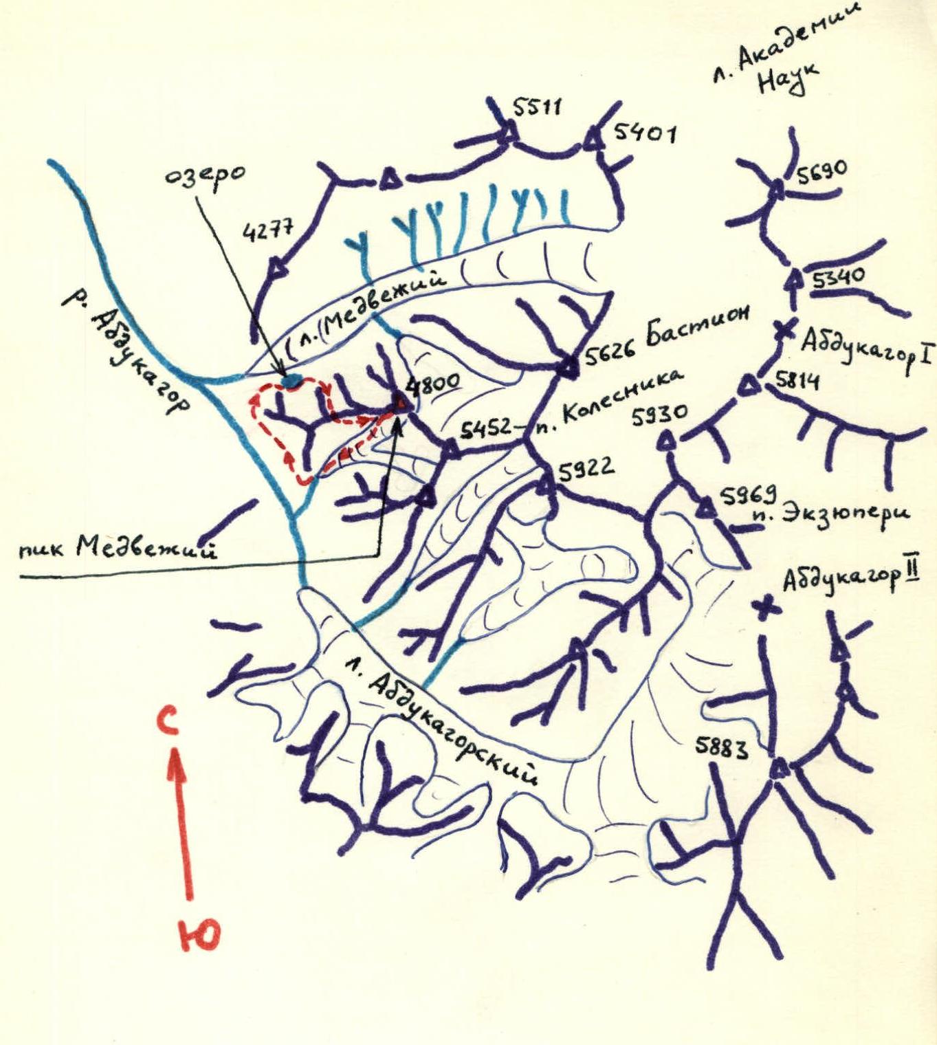
→ → — group route
Route description
Map of the ascent area. The ascent on July 12, 1979, was made by a group from the Leningrad Regional Council of DOSAAF "Trud" consisting of:
leader — Ivanov D.A., 2nd sports category; participants — Novikov E.D. — CMS; Li G.D. — 2nd sports category, Belyaev M.B. — 2nd sports category, Shevtsov S.E. — 2nd sports category.
Pik Medvezhiy is located in the Central Pamir in the Western spur of the Akademiya Nauk range, dividing the valleys of the Medvezhiy glacier and the Abdukagor river (see orographic diagram). In the same spur are: — Pik Bastion (5626 m); — Pik Kolesnika (5452 m).
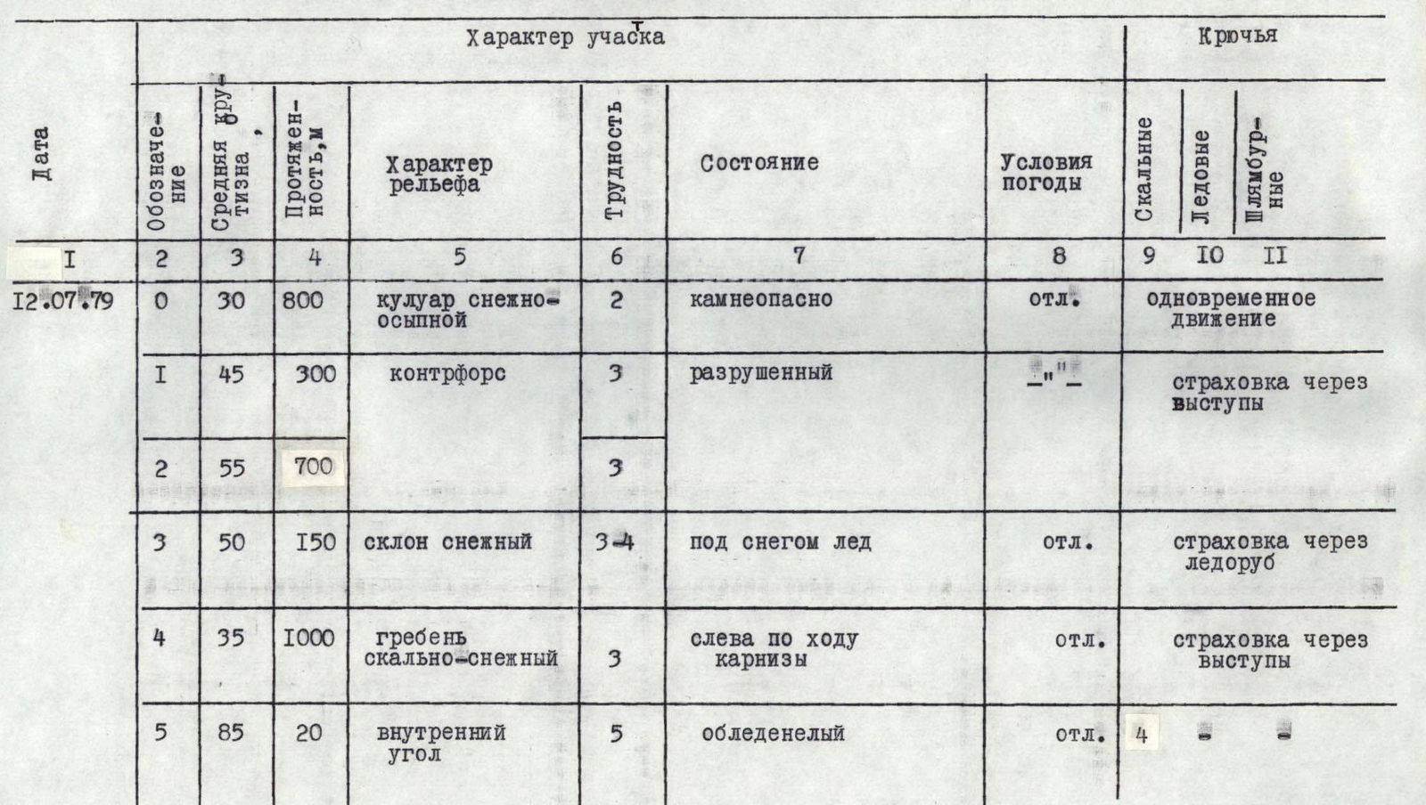
From the base camp on the left-bank moraine (orographically) of the Medvezhiy glacier — up the moraine to the second (on the right, in the direction of travel) couloir.
The couloir is snow-scree (difficulty category 2). Up the middle of the couloir and then right, transition to a rocky counterfort that leads to the West Ridge of Pik Medvezhiy. The couloir is rockfall-prone in its upper part!!!
Up simple rocks of the counterfort (difficulty category 3) to the 1st control cairn. Further up rocks of medium difficulty. The rocks are heavily broken. Protection through rock features.
Exit to the ridge via a steep snowy slope (difficulty category 3). Protection via ice axe. On the ridge — 2nd control cairn.
Further along the ridge in the direction of the summit of Pik Medvezhiy. The ridge is rocky-snowy (difficulty category 3). The rocks are broken. Protection through rock features. On the ridge, to the left (in the direction of the Medvezhiy glacier) — snow cornices!!! The ridge's obstacles are overcome directly or bypassed on the right. Along the ridge to the summit tower (see Fig. 2). Under the tower — 3rd control cairn.
The summit tower is overcome via an inside corner (20 m, 85°, difficulty category 5). Key point of the route. Climbing is difficult. Piton protection. On the summit — control cairn.
From the base camp to the summit — 9–10 hours.
Descent from the tower to the ridge via rappel down the ascent route. Descent from the ridge to the south (left, in the direction of travel) into the cirque of Piki Kolesnika and Snezhnogo. Down a simple snowy-scree slope to the glacier and further down the glacier to the Abdukagor river. A bergschrund in the lower part of the glacier is overcome via rappel (6 m).
On July 24, 1979, the route was repeated by a group from LOS DSO "Trud" consisting of: — leader — Ponurin V.P., 2nd sports category; — participants — Bolonin V.P., 1st sports category, instructor; — Melnikov V.D., 3rd sports category; — Kuznetsov E.V., 2nd sports category.
The group agrees with the assessment of the route's difficulty category.
Table of main characteristics of the ascent route