Introduction
Peak Evgenia Korzhenevskaya is the fourth highest seven-thousander in the country (7105 m). Despite being near Peak Kommunizma (7495 m), Peak Evgenia looks very majestic. Its giant summit dome is visible from the Zaalaysky ridge pass from Ters-Agar to Khodzha-Toо.
The approaches to it are very difficult:
- The path is blocked by the mighty river of the Pamir - Muk-su;
- But the difficulties do not end there: the path along the left (orogr.) side of Muk-su is often blocked by deep, steep-walled sairs cut by turbulent rivers originating from the glaciers of the Academy of Sciences and Peter the First ridges.
The approaches to Peak Evgenia Korzhenevskaya are relatively simple only along the valley of the Mushketov Glacier; from here it looks dazzlingly magnificent. The approach along the Ayu-Dzhilga valley is difficult: the river flows in a narrow canyon. But even having overcome the difficulties of approaching the Ayu-Dzhilga Glacier, one will not feel relief: the path to Peak Evgenia leads up steep, artificially polished black walls.
The path along the Fortambek valley is blocked by a canyon of the river only in one place. All routes to Peak Evgenia Korzhenevskaya that have been completed so far start from the Fortambek valley.
It is precisely the inaccessibility of the summit that EXPLAINS the rare expeditions aimed at conquering it. Without helicopters, this undertaking is extremely cumbersome. Currently, there are several helicopter landing sites at the foot of the peak, and therefore interest in this summit has increased significantly. Six different routes have been completed, but it cannot be said that the peak is fully explored and climbing it is not challenging. A characteristic feature of most of these high-altitude routes is the high demands they make on the technical preparation of climbers.
Below is a description of the ascent to Peak E. Korzhenevskaya by a group that was part of the CS SDO "Burevestnik" expedition (headed by z.m.s. A. G. Ovchinnikov, senior coach z.m.s. K. K. Kuzmin) via the Eastern ridge in August 1966.
PROFILE SCHEME OF THE ASCENT ROUTE TO Peak E. KORZHENEVSKAYA VIA THE EASTERN RIDGE
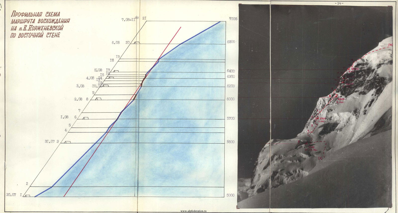
Photo 2. The massif of Peak E. Korzhenevskaya from the ridge of Peak Chetyrekh 6000 m.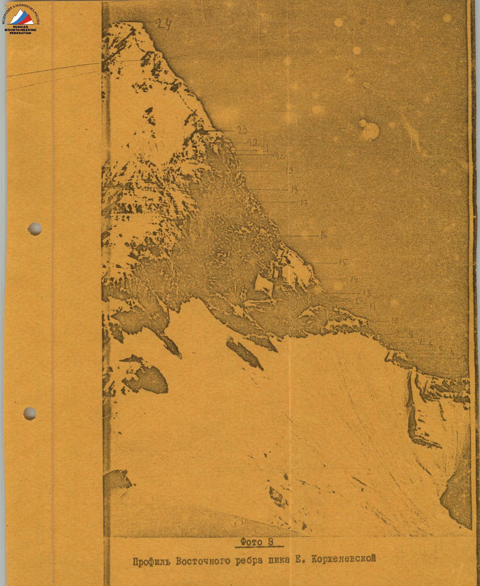
Profile of the Eastern ridge of Peak E. Korzhenevskaya
Description of the route via the Eastern ridge of Peak Evgenia Korzhenevskaya (7105 m)
From the base camp located in the "pocket" of the left (orogr.) moraine of the Moskvina Glacier, we first go up the "pocket" to the point where the Walter Glacier flows into the Moskvina Glacier. Here we cross the Walter Glacier and again exit into the "pocket" of the left (orogr.) moraine of the Moskvina Glacier. Further up, we go along the moraine of the glacier to the end of the moraine. Above, the glacier forms a gentle icefall. By-passing hidden crevasses from the edge of the icefall, we exit into the upper circus of the Moskvina Glacier.
- Attention! Avalanches from the slopes of Peak MFTI.
We cross the glacier and set up camp № 1. (4900 m, see the map of the area). The journey from the base camp (4000 m) takes 5-6 hours.
Next, we make a steep ascent up the talus slope of Peak Chetyrekh, and then traverse along the snow slopes of this peak to the left, trying not to lose height, until we enter the circus of the right (orogr.) tributary of the Moskvina Glacier. Above, steep snow ascents begin. We move, sticking to the right part of the circus. In some places, the snow is very loose, and we have to dig a trench. Rappel via an ice axe is used only when exiting onto the Eastern ridge at its lowest point. Here we set up camp № 2 (6100 m, point 1). The journey from camp (4900 m) takes 6-7 hours.
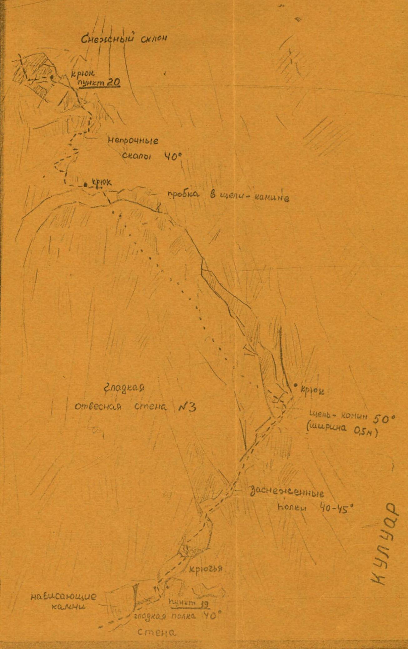
Further, we move along the snowy ridge with a series of rocky "gendarmeres" (photo 4). Up to the first "gendarme", the ridge is wide and gentle. The "gendarme" is bypassed on the right by a steep snowy slope (30 m), ending in a bergschrund. The bergschrund is passed in the left part. We move 30 m along the snowy ridge to the second "gendarme" (point 3). It is climbed "head-on" via rocks of medium difficulty with piton belay (20 m) and we exit onto a snowy ridge with cornices. After 30 m, we approach the third "gendarme" (point 5). It is overcome with piton belay via rocks of medium difficulty also "head-on" (20 m). After 30 m along the snowy ridge with cornices, we approach the fourth "gendarme" (point 7). It is bypassed on the left via a steep rocky-ice couloir (20 m) with careful piton belay. In the upper part, the couloir leads to a narrow ridge with delicate cornices. Along the steep snowy-ice slope of the ridge, after 30 m, we approach the base of the wall of the fifth "gendarme".
An expansion of the route via the Eastern ridge of Peak E. Korzhenevskaya on the section (see photos 2-4)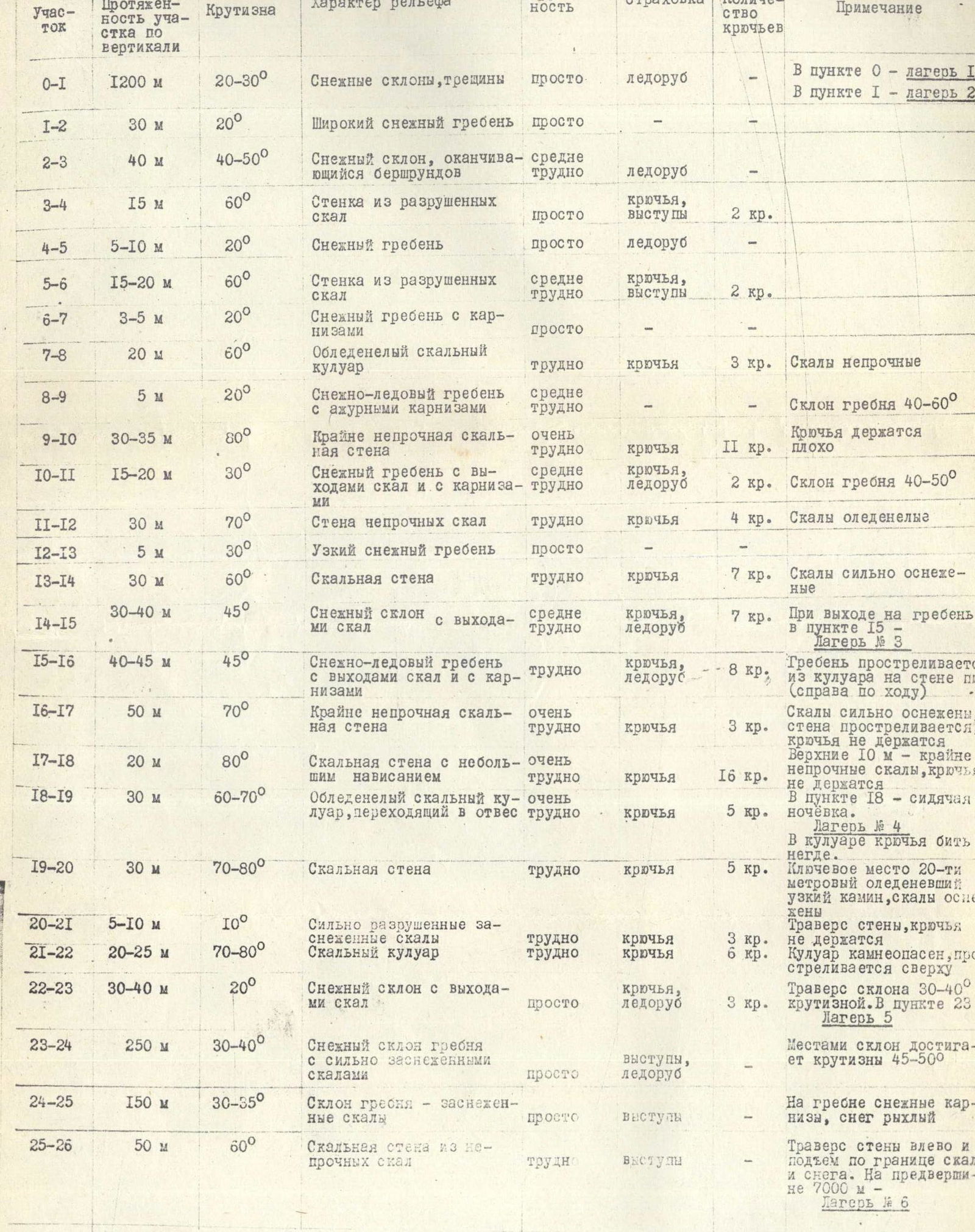 (point 9). The "gendarme" is climbed "head-on" via very difficult loose rocks with piton belay (30 m) (photo 5). Further, after 40-50 m of a simple snowy ridge, we approach the sixth "gendarme" (point 11). Again, difficult climbing when passing the "gendarme" "head-on" (30 m). The narrow ridge leads after 15-20 m to a wall, which is climbed with piton belay on the right (40 m). Above the wall, a steep wide snowy ridge begins. We move up and to the right along this ridge. At the top, the ridge turns left again, becomes sharp, and is crowned with cornices. Having hacked off a cornice, we set up a tent for camp № 3 (6350 m) (photo 6, point 15).
Further, the ridge loses its pronounced character and turns into a wall (photo 7). After three rope lengths along the steep snowy-ice ridge, we approach the base of the first wall (point 16).
Attention! The ridge in the upper part is exposed to rocks falling from the couloir to the right of the ridge.
The wall is climbed on the right via steep, very unreliable snow-covered rocks. It is difficult to organize belay. Along these rocks, after 80-90 m, we exit onto a ridge above the wall.
Above, there are very complex rocks with a slight overhang. We climb them via free climbing with careful piton belay (15 m) (climbing is very difficult), then after 10-15 m - steep, very loose rocks - we approach under the second wall. Here we set up a bivouac - camp № 4 (6450 m) (photo 8, point 18).
The second wall is also climbed on the right: first via difficult, heavily snow-covered rocks, and then via a steep rocky-ice couloir (30 m), turning into a sheer wall at the top, leading to a sharp ridge under the base of the third wall, point 19.
Further, along complex rocks with careful piton belay, we move 20 m up and to the right, bypassing the smooth wall, to a crack that cuts through the wall. Along a narrow chimney, we climb to the top of the wall (20 m). Further:
- Along strongly destroyed rocks, we first move up (10 m) to the end of the wall,
- Then we traverse above the wall 30-40 m to the left into a couloir that leads to the Southeast ridge of Peak Evgenia Korzhenevskaya (point 21).
Along a steep rocky couloir (40 m) - Attention! Rockfall hazard! - and then along a snowy slope, we exit onto the ridge. Here we set up camp № 5 (6550 m) (point 23).
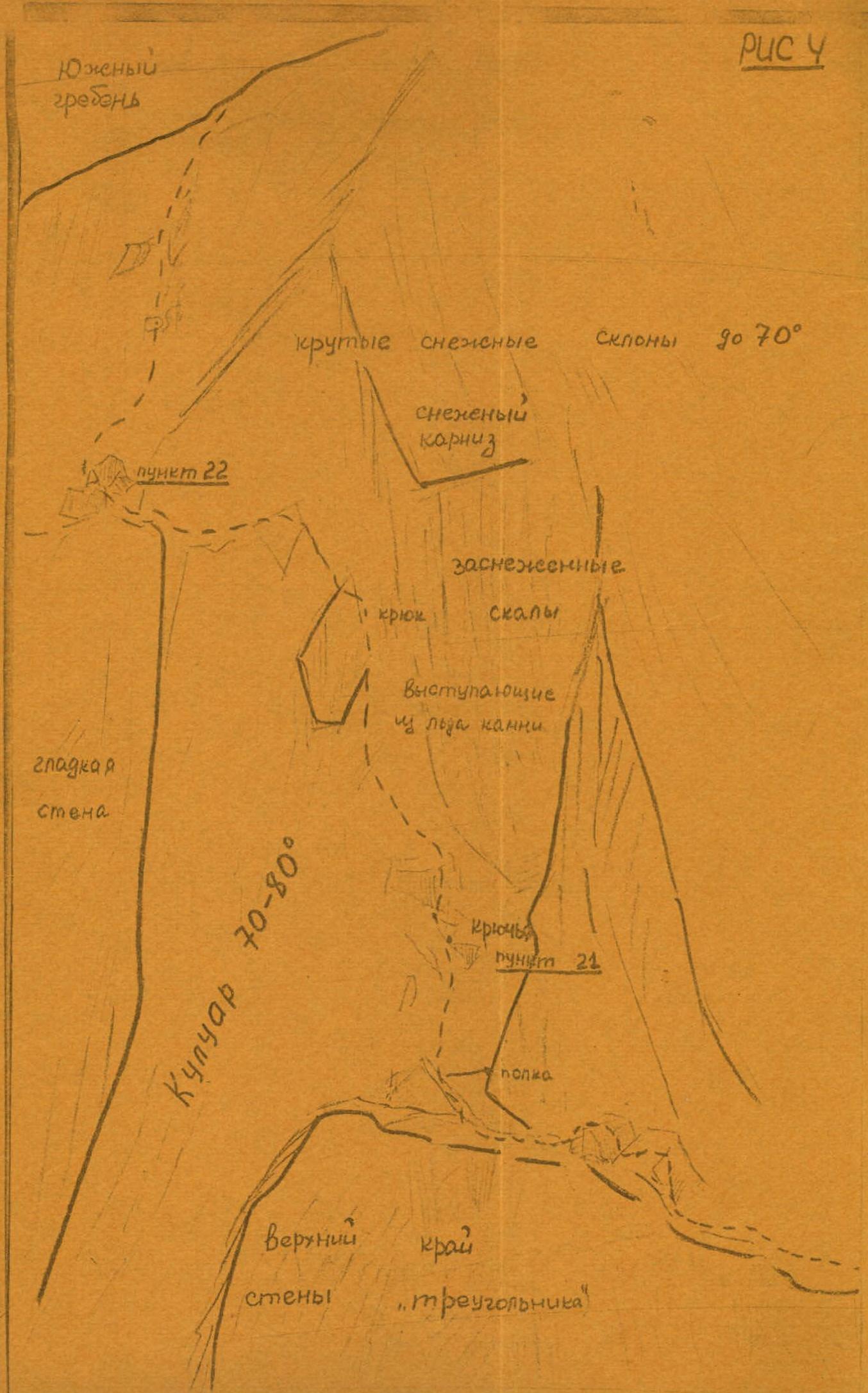
Above, the Southeast ridge ends in huge cornices to the east, so we have to climb up the western slope of the ridge. Simple rocks and rocks of medium difficulty (heavily snow-covered) alternate with snow (photo 3). Up to the beginning of the summit Eastern ridge (point 24), the steepness of the ascent is 35-40°. Then there is a slight descent along the Eastern ridge and then a steep ascent to the Pre-summit via snow-covered rocks (photo 1, 2, point 25).
In the upper part, the destroyed rocks are free of snow and reach a steepness of 60°. With belay via ledges, we traverse to the left, bypassing the rocky wall, and exit onto the Pre-summit (7000 m, point 26). Here we set up camp № 6 (7000 m).
From here, the summit is already nearby. The path lies along a simple snowy ridge. Descent from the summit is via the South ridge (photo 1).
Division of the route into sections
(see photos 2, 3, 4)
Section O–1
- Vertical extent of the section: 1200 m
- Steepness: 20–30°
- Terrain characteristics: Snowy slopes, crevasses
- Difficulty: easy
- Belay: ice axe
- Number of pitons: —
- Note: In point 0 - camp 1, in point 1 - camp 2.
Section 1–2
- Vertical extent of the section: 30 m
- Steepness: 20°
- Terrain characteristics: Wide snowy ridge
- Difficulty: easy
- Belay: —
- Number of pitons: —
- Note: —
Section 2–3
- Vertical extent of the section: 40 m
- Steepness: 40–50°
- Terrain characteristics: Snowy slope ending in a bergschrund
- Difficulty: moderately difficult
- Belay: ice axe
- Number of pitons: —
- Note: —
Section 3–4
- Vertical extent of the section: 15 m
- Steepness: 60°
- Terrain characteristics: Wall of destroyed rocks
- Difficulty: easy
- Belay: pitons, ledges
- Number of pitons: 2 pt.
- Note: —
Section 4–5
- Vertical extent of the section: 5–10 m
- Steepness: 20°
- Terrain characteristics: Snowy ridge
- Difficulty: easy
- Belay: ice axe
- Number of pitons: —
- Note: —
Section 5–6
- Vertical extent of the section: 15–20 m
- Steepness: 60°
- Terrain characteristics: Wall of destroyed rocks
- Difficulty: moderately difficult
- Belay: pitons, ledges
- Number of pitons: 2 pt.
- Note: —
Section 6–7
- Vertical extent of the section: 3–5 m
- Steepness: 20°
- Terrain characteristics: Snowy ridge with cornices
- Difficulty: easy
- Belay: —
- Number of pitons: —
- Note: —
Section 7–8
- Vertical extent of the section: 20 m
- Steepness: 60°
- Terrain characteristics: Icy rocky couloir
- Difficulty: difficult
- Belay: pitons
- Number of pitons: 3 pt.
- Note: Rocks are unreliable.
Section 8–9
- Vertical extent of the section: 5 m
- Steepness: 20°
- Terrain characteristics: Snowy-icy ridge with delicate cornices
- Difficulty: moderately difficult
- Belay: —
- Number of pitons: —
- Note: Ridge slope is 40–60°.
Section 9–10
- Vertical extent of the section: 30–35 m
- Steepness: 80°
- Terrain characteristics: Extremely unreliable rocky wall
- Difficulty: very difficult
- Belay: pitons
- Number of pitons: 11 pt.
- Note: Pitons hold poorly.
Section 10–11
- Vertical extent of the section: 15–20 m
- Steepness: 30°
- Terrain characteristics: Snowy ridge with rock outcrops and cornices
- Difficulty: moderately difficult
- Belay: pitons, ice axe
- Number of pitons: 2 pt.
- Note: Ridge slope is 40–50°.
Section 11–12
- Vertical extent of the section: 30 m
- Steepness: 70°
- Terrain characteristics: Wall of unreliable rocks
- Difficulty: difficult
- Belay: pitons
- Number of pitons: 4 pt.
- Note: Rocks are icy.
Section 12–13
- Vertical extent of the section: 5 m
- Steepness: 30°
- Terrain characteristics: Narrow snowy ridge
- Difficulty: easy
- Belay: —
- Number of pitons: —
- Note: —
Section 13–14
- Vertical extent of the section: 30 m
- Steepness: 60°
- Terrain characteristics: Rocky wall
- Difficulty: difficult
- Belay: pitons
- Number of pitons: 7 pt.
- Note: Rocks are heavily snow-covered.
Section 14–15
- Vertical extent of the section: 30–40 m
- Steepness: 45°
- Terrain characteristics: Snowy slope with rock outcrops
- Difficulty: moderately difficult
- Belay: pitons, ice axe
- Number of pitons: 7 pt.
- Note: Upon exiting onto the ridge at point 15 - camp № 3.
Section 15–16
- Vertical extent of the section: 40–45 m
- Steepness: 45°
- Terrain characteristics: Snowy-icy ridge with rock outcrops and cornices
- Difficulty: difficult
- Belay: pitons, ice axe
- Number of pitons: 8 pt.
- Note: Ridge is exposed to rocks from the couloir on the wall of the peak (to the right).
Section 16–17
- Vertical extent of the section: 50 m
- Steepness: 70°
- Terrain characteristics: Extremely unreliable rocky wall
- Difficulty: very difficult
- Belay: pitons
- Number of pitons: 3 pt.
- Note: Rocks are heavily snow-covered, wall is exposed to rocks, pitons do not hold.
Section 17–18
- Vertical extent of the section: 20 m
- Steepness: 80°
- Terrain characteristics: Rocky wall with a slight overhang
- Difficulty: very difficult
- Belay: pitons
- Number of pitons: 16 pt.
- Note: Upper 10 m - extremely unreliable rocks, pitons do not hold.
Section 18–19
- Vertical extent of the section: 30 m
- Steepness: 60–70°
- Terrain characteristics: Icy rocky couloir turning into a sheer wall
- Difficulty: very difficult
- Belay: pitons
- Number of pitons: 5 pt.
- Note: In point 18 - sitting bivouac, camp № 4.
Section 19–20
- Vertical extent of the section: 30 m
- Steepness: 70–80°
- Terrain characteristics: Rocky wall
- Difficulty: difficult
- Belay: pitons
- Number of pitons: 5 pt.
- Note: In the couloir, there is nowhere to place pitons. Key point - 20-meter icy narrow chimney, rocks are snow-covered.
Section 20–21
- Vertical extent of the section: 5–10 m
- Steepness: 10°
- Terrain characteristics: Strongly destroyed snow-covered rocks
- Difficulty: difficult
- Belay: pitons
- Number of pitons: 3 pt.
- Note: Traverse of the wall, pitons do not hold.
Section 21–22
- Vertical extent of the section: 20–25 m
- Steepness: 70–80°
- Terrain characteristics: Rocky couloir
- Difficulty: difficult
- Belay: pitons
- Number of pitons: 6 pt.
- Note: Couloir is exposed to rockfall, is fired upon from above.
Section 22–23
- Vertical extent of the section: 30–40 m
- Steepness: 20°
- Terrain characteristics: Snowy slope with rock outcrops
- Difficulty: easy
- Belay: pitons, ice axe
- Number of pitons: 3 pt.
- Note: Traverse of the slope with 30–40° steepness. In point 23 - camp № 5.
Section 23–24
- Vertical extent of the section: 250 m
- Steepness: 30–40°
- Terrain characteristics: Snowy slope of the ridge with heavily snow-covered rocks
- Difficulty: easy
- Belay: ledges, ice axe
- Number of pitons: —
- Note: In some places, the slope reaches 45–50° steepness.
Section 24–25
- Vertical extent of the section: 150 m
- Steepness: 30–35°
- Terrain characteristics: Ridge slope - snow-covered rocks
- Difficulty: easy
- Belay: ledges
- Number of pitons: —
- Note: On the ridge, there are snowy cornices, snow is loose.
Section 25–26
- Vertical extent of the section: 50 m
- Steepness: 60°
- Terrain characteristics: Rocky wall of unreliable rocks
- Difficulty: difficult
- Belay: ledges
- Number of pitons: —
- Note: Traverse of the wall to the left and ascent along the boundary of rocks and snow. On the Pre-summit (7000 m) - camp № 6.
Note
All rocky sections between camps № 2 and № 5 can only be overcome without a backpack.
Conclusion
The group members (Bozhukov, Kuzmin) have experience climbing routes of 6B category of difficulty: Peak Kommunizma via the counterfort of the South wall - Peak Revolyutsii from the Fedchenko Glacier - Peak Khan-Tengri from the North - Peak Pobeda via the Western shoulder.
The group includes winners of the spring championship of Moscow in rock climbing 1964–1966 (Borodkin, Nadbakh, Skurlatov).
Comparing with the routes previously climbed by the group members, the route to Peak Evgenia Korzhenevskaya via the Eastern ridge, in the opinion of the group members, should be rated 6B category of difficulty.
Recommendations
It is desirable that the group consists of 5 people, since there is nowhere to set up more than one tent on the route (between camps № 2 and № 5). The group's equipment must include:
- Long titanium channel pitons;
- Ice pitons.
Passing the route in crampons is extremely difficult; the best option is insulated boots with fur socks.
The route from camp № 2 to camp № 5 everywhere requires preliminary processing with the installation of ropes. In view of this, the group must be equipped with ascenders.
Diary of the ascent of the Bozhukov group to Peak E. Korzhenevskaya via the Eastern ridge
Group composition:
- Bozhukov V. M. - leader, MS to the summit
- Kuzmin K. K. - coach, z.m.s. —
- Egorov V. P. - participant, Honored MS to camp № 2
- Danilov V. V. - MS —
- Galkin V. T. - 1st sports category to camp № 6
- Borodkin D. V. - 1st sports category —
- Nadbakh-Kiedesa V. M. - 1st sports category —
- Skurlatov D. I. - 1st sports category —
All group members had excellent physical preparation. Egorov and Danilov train year-round according to individual plans. The group members seriously prepared for this ascent, starting from the fall of the previous year, according to a training plan specially developed by V. M. Bozhukov. In winter, the group went to the Caucasus with the goal of climbing Elbrus, but harsh weather conditions did not allow them to climb higher than the Pastukhov rocks. From April, on Saturdays-Sundays, all expedition participants trained together at camps in the Moscow region. Immediately upon arrival in the mountains, the group members continued their training. Except for Danilov, everyone made a five-day hike from the village of Lakhsh (2000 m) to the Base camp (4000 m). Further, acclimatization exits were made to Peak MFTI (5700 m), Peak Chetyrekh (6300 m), and to the drop-off point under the Eastern ridge of Peak Evgenia (6100 m).
The medical examination data indicated very good fitness and acclimatization of all group members.
Before exiting onto the route, camp № 1 (4900 m) was set up, and a drop was made to the location of camp № 2 (6100 m): 11 kg of equipment, 30 kg of food.
Passage of the route:
1st day - August 6, 1966
The group exits the Base camp (4000 m) to camp № 1 in full strength. The journey takes 5 hours.
2nd day
Part of the group goes to camp № 2. The journey takes 6 hours. Galkin remains in camp № 1 as an observer for the Bozhukov, Danilov duo, who are climbing Peak MFTI (5700 m).
The Nadbakh, Skurlatov duo conducts a reconnaissance of the route from camp № 2 to point 9. The reconnaissance takes 2.5-3 hours.
3rd day
The Nadbakh, Skurlatov duo ascends lightly to point 9 and begins processing the rocky wall. Egorov and Borodkin:
- Install ropes up to point 9. Then:
- Egorov and Nadbakh continue processing the wall;
- The duo descends to camp № 2.
Processing up to point 10 takes 6 hours.
Bozhukov, Danilov, and Galkin ascend to camp № 2.
4th day
The Bozhukov, Nadbakh duo ascends to point 10 and processes the further path to point 15. Processing takes 7 hours. Borodkin and Skurlatov carry a load to point 11. Kuzmin and Egorov climb a nameless peak 6216 m.
In the evening, Danilov feels unwell. A general meeting of the participants is held.
5th day
The Egorov, Danilov duo, under observation, heads down to camp № 1 (photo 9). The rest dismantle camp № 2, ascend to point 15, and set up camp № 3 (6350 m) there. The journey takes 7 hours.
6th day
The Bozhukov, Nadbakh duo processes the further path. Borodkin and Skurlatov carry loads to points 16 and 17. Then Bozhukov and Borodkin continue processing the complex wall with a slight overhang above point 17. Processing takes 8 hours.
7th day
Camp № 3 is dismantled. The Bozhukov, Skurlatov duo continues processing the route lightly to point 21. Processing takes 4 hours. The rest ascend to point 18 and set up a sitting bivouac - camp № 4 (6450 m) there. The ascent to camp № 4 takes 6 hours.
8th day
Camp № 4 is dismantled. The Bozhukov, Nadbakh duo processes section 21–22. Further, Kuzmin, Borodkin traverse the snowy slope, install ropes, and set up camp № 5 (6550 m) in point 23. The ascent from camp № 4 to camp № 5 takes 10-11 hours.
9th day
Camp № 5 is dismantled. Above, there is an ascent along the rocky-snowy slope of the ridge. The Kuzmin, Borodkin duo leads. On the Pre-summit, camp № 6 (7000 m) is set up. The journey takes 8 hours.
10th day
At night, Skurlatov falls ill. Early in the morning, the Bozhukov, Kuzmin duo ascends to the summit of Peak Evgenia Korzhenevskaya (the journey takes 50 minutes), gives a distress signal, and from there surveys the optimal possible route for descending the sick person. Transportation of the sick person begins down to a height of 6100 m. The descent takes 8 hours (photo 1).
The Kuzmin, Borodkin duo continues descending to the Base camp.

Figure 1
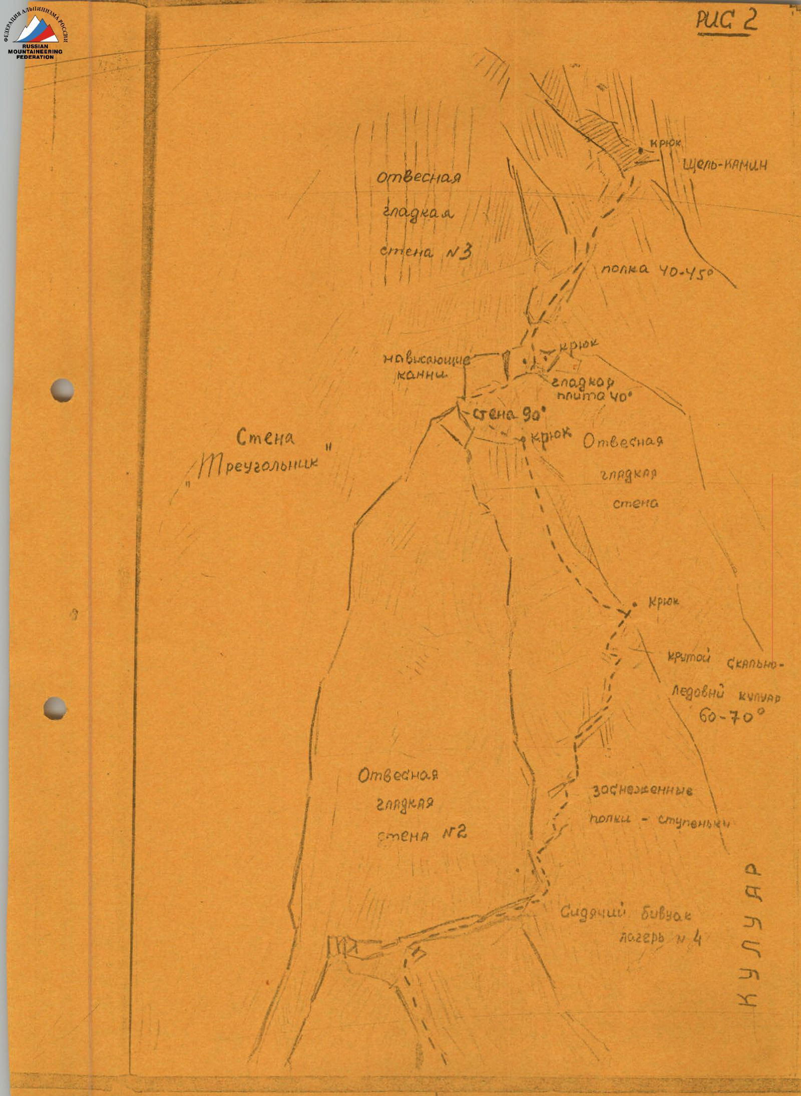
Figure 2