PASSPORT
- High-altitude class
- Pamir, Akademiya Nauk Range
- Peak Kommunizma 7495 m via the left counterfort from Stalin Glacier
- Proposed – category 5B difficulty, first ascent
- Elevation gain: 2895 m, length – 5300 m Rock section elevation gain 1780 m, length of rock section – 2320 m Length of grade 5–6 sections – 540 m Average steepness of the rock section – 51°
- Pitons used: rock 94, chocks 85, ice screws 16
- Team's climbing hours: 38 and days – 3.5
- Overnight stops: 1 – semi-reclined; 2 – reclined; 3 – reclined
- Leader: Grigoriy Yevgenyevich Lunyakov, Master of Sports
Team members:
- Aleksandr Pavlovich Kukushkin, Candidate for Master of Sports
- Yuriy Mikhaylovich Moiseyev, Master of Sports
- Vladimir Ivanovich Suviga, Master of Sports
- Valeriy Nikolayevich Khrishtchatyy, Honored Master of Sports
- Andrey Vladimirovich Tselishchev, Candidate for Master of Sports
- Coach: Kazbek Shakimovich Valiev
- Route start: 9:00, August 9, 1987 Summit – August 12, 1987 Return – August 14, 1987
- Organization: Alpinist Club 12, CAA, SAVO
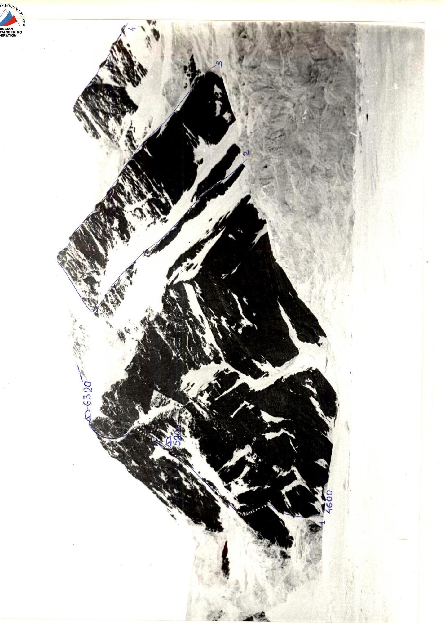
General photo of the route
General photo of the route
1 — team's route, 2 — Kustovsky's route
3 — Budanova
4 — Abalakov's
Shooting point #2, distance – 2 km, lens 7–43 4/40 LOMO
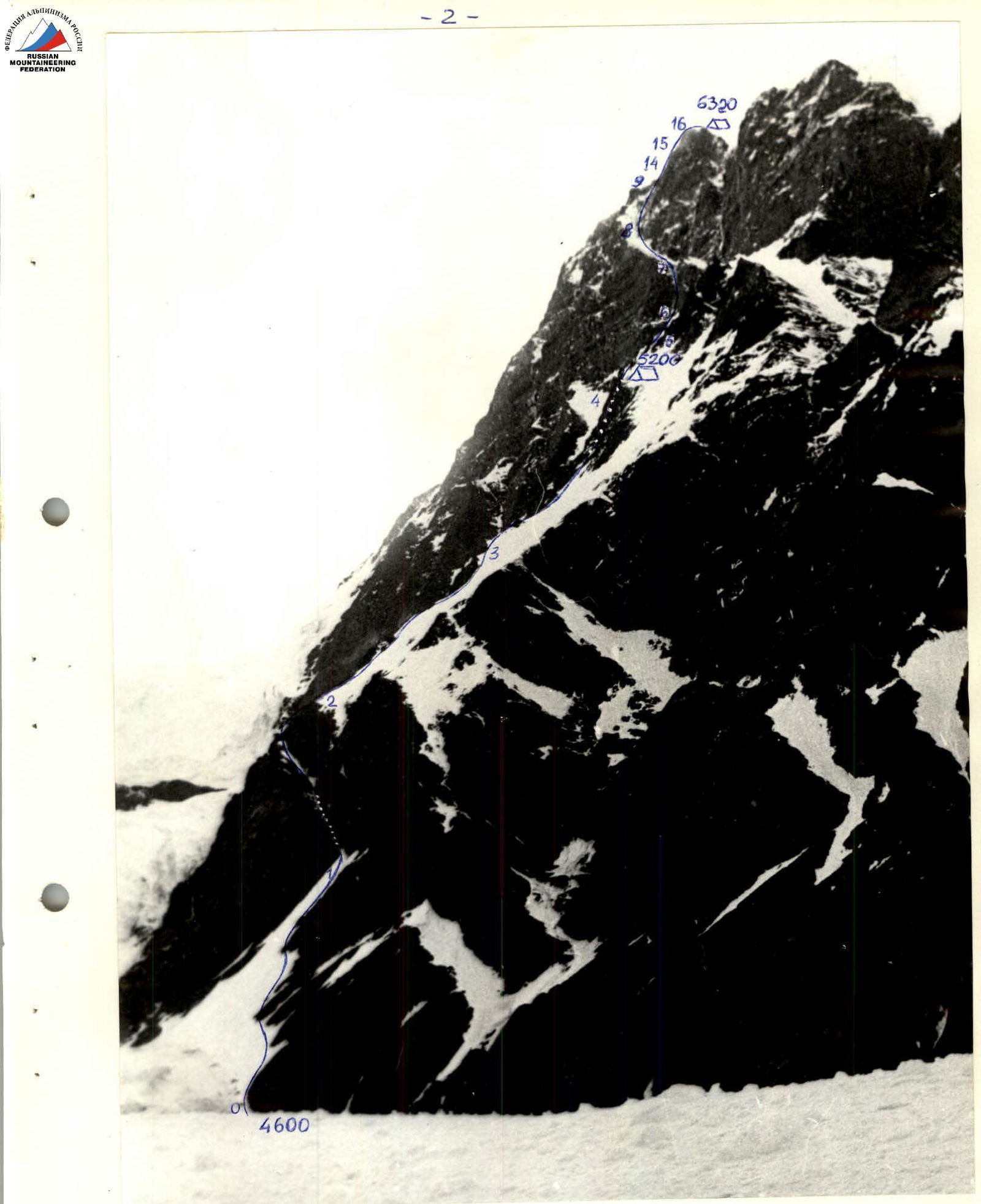
Route profile
Route profile on the right
Shooting point #3
Lens 7–43 4/40 LOMO
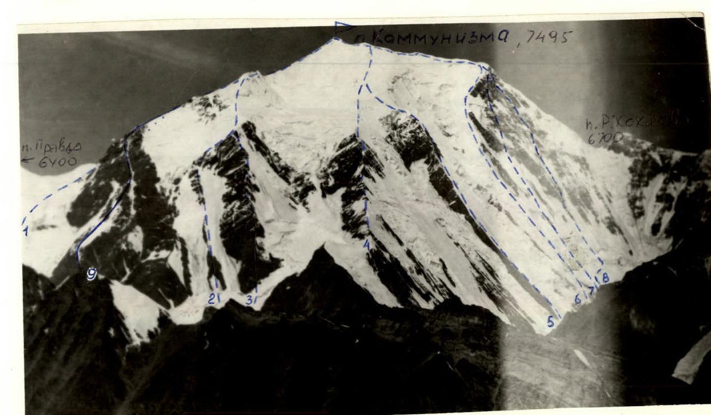
Photo panorama of the area. Routes: 1 — Tamm, 2 — Kustovsky, 3 — Budanov, 4 — Abalakov, 5 — Voronin, 6 — Borisenko, 7 — Chunovkin, 8 — Putintsev, 9 — Lunyakov (CCAA SAVO-1987). August 10, 1987, 11:00, T–Y3 4/40 LOMO, 5 km, N4, 4800 m.
Team's tactical actions
The team's tactical actions were conducted in accordance with the developed plan. The main task was to safely overcome the lower part of the rock counterfort (exposed to the right serac). To achieve this, it was decided to traverse this section before sunrise, i.e., from 4:00 to 7:30.
Based on the physical capabilities of the participants, the route could be completed in a shorter time, but due to the heavy avalanche situation in the upper part of the route that season, it was planned to work until 15:00.
During the ascent, the team coordinated their actions, with rope teams changing leaders both within and between teams. Belay points and overnight stops were chosen in locations protected from rockfall. The diet included daytime snacks. There were no safety breaches, falls, or injuries. The route was completed with a good reserve of physical strength.
Route sections table
| Overnight stops | By height, m | Length, m | Hours taken | Difficulty category | Length, m | Steepness | Section # |
|---|---|---|---|---|---|---|---|
| 5900 | 40° | R29 | |||||
| 5 | 60 | 75° | R27 | ||||
| 5 | 60 | 75° | R26 | ||||
| 220 | 385 | 5 | 50 | 70° | R25 | ||
| 11.5 | 5 | 160 | 75° | R24 | |||
| 1 | 5680 | ||||||
| 380 | 600 | 16 | |||||
| / including 170 m on previously fixed ropes / | |||||||
| 5 | 240 | 75° | R23 | ||||
| 4 | 80 | 60° | R22 | ||||
| 5 | 40 | 75° | R21 | ||||
| 5 | 50 | 85° | R20 | ||||
| 4 | 70 | 70° | R19 | ||||
| 5360 | 5 | 120 | 80° | R18 | |||
| 100 | 130 | 10.5 | |||||
| 5 | 50 | 55° | R17 | ||||
| 5260 | 5 | 100 | 75° | R16 | |||
| 300 | 480 | 13 | |||||
| 4 | 120 | 60° | R15 | ||||
| 4 | 60 | 75° | R14 | ||||
| 4960 | 5 | 140 | 65° | R13 | |||
| 3 | 100 | 60° | R12 | ||||
| 4 | 4 | 60 | 60° | R11 | |||
| 3 | 150 | 50° | R10 | ||||
| 4 | 60 | 70° | R9 | ||||
| 6 | 15 | 90° | R8 | ||||
| 480 | 675 | 14 | |||||
| 4 | 200 | 70° | R7 | ||||
| 4480 | 4 | 125 | 65° | R6 | |||
| 2 | 65 | 50° | R5 | ||||
| 4 | 90 | 70° | R4 | ||||
| 580 | 700 | 9 | |||||
| 2 | 300 | 50° | R3 | ||||
| 4 | 100 | 70° | R2 | ||||
| 3 | 100 | 50° | R1 | ||||
| 3 | 3900 | 3 | 110 | 50° | R0 |
Route description by sections
- R0–R1 Snow couloir. Movement with simultaneous belay through pitons.
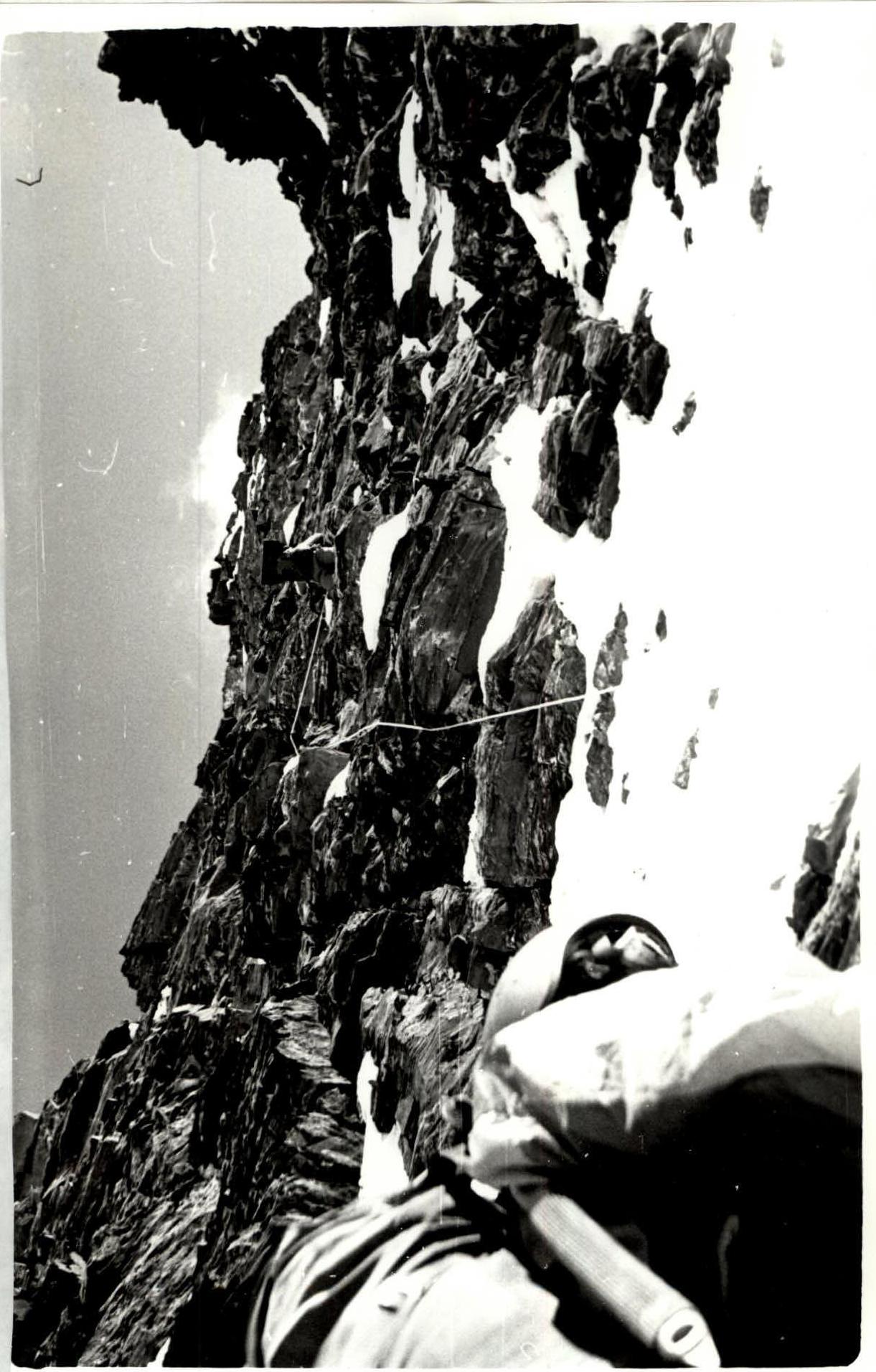
- R1–R2 Wall with a chimney. Smoothed rocks, covered in ice (see photo). Cramp-on movement. Piton belay. Peril placement.
- R2–R3 Rock ridge. Rocks are damaged, tile-like. Alternating movement with piton belay.
- R3–R4 Continuation of the rock ridge. Rocks are more damaged. Movement with alternating belay.
- R4–R5 Ice-firn slope.
- R5–R6 Steep rock ridge. Alternating movement.
- R6–R7 Couloir with ice formations. Peril placement. Cramp-on movement.
- R7–R8 Rock ledge with ice formations. Cramp-on movement with alternating belay and peril placement.
- R8–R9 Rock ridge. Alternating movement with belay.
- R11–R12 Rock ridge. Peril placement.
- R13–R14 Couloir, rocks covered in ice. Cramp-on movement. Peril placement.
- R14–R15 Wall. Icy rocks. Cramp-on movement, peril placement.
- R15–R16 Damaged couloir. Rocks covered in ice. Cramp-on movement, peril placement.
Further movement to the summit – along snow slopes and sharp snow ridges with simultaneous and alternating belay.
Route sections diagram
Pitons: Rock: 12, 14 Chocks: 8, 8 Ice screws: 7, 1
6320 m, 144, 121 pitons, 2004. T = 4600 m
Sections: R16: V (5) 55°, 160 m, 60–120 R15: V (5) 65° R14: V (5) 60° R13: III (3) 60°, 200 m R12: IV (4) 55°, 110 m R11: IV (4) 50°, 100 m R10: II (2) 35° R9: IV (4) 50°, 300 m R8: V (5) 55°, 80 m R7: V (5) 65°, 70 m R6: IV (4) 55°, 80 m R5: II (2) 35°, 60 m R4: II (2) 50°, 400 m R3: IV (4) 50°, 300 m R2: II (2) 70°, 240 m R1: II (2) 35°, 350 m
5200 m, 164, 49 pitons, 1 overnight stop.
Photo #1. Section R1–R2.

Photo #5. Section R14–R15.