
Report
TEAMS OF CS DSO «MEKHNAT» ON ASCENT TO PEAK KOMMUNIZMA VIA NORTH-EAST FACE IN THE PROGRAM OF THE USSR CHAMPIONSHIP IN ALPINISM IN THE HIGH-ALTITUDE CLASS
Tashkent — 1978 to Peak Kommunizma 7495 m

Brief Geographical Description and Sporting
Characteristics of the Object
Peak Kommunizma 7495 m is the highest peak in the Pamir Mountains, located at the junction of the Akademiya Nauk and Petra I ranges. The height of the peak was first determined by the Soviet-German expedition in 1928.
In 1933, a special alpinist group was included in the Tajik-Pamir expedition with the task of ascending to the peak. The group was led by N. P. Gorbunov, the head of TPE-33. The assault on the peak was conducted from the east, from the side of the Bivachny Glacier.
The group of alpinists, having processed the eastern ridge of the peak and organized a series of high-altitude camps, ensured a successful ascent to the peak. On September 3, Yevgeny Abalakov reached the highest point of the peak. N. P. Gorbunov ascended to the pre-summit ridge (7300 m).
Peak Kommunizma attracts alpinists not only as the highest point in the USSR but also as a very complex and interesting sporting object, abounding with challenging routes from all cardinal directions. In recent years, ascents to the peak have been mastered along all ridges and edges, extended traverses have been made, including all surrounding major peaks, including the neighboring seven-thousander — Peak E. Korzhenevskaya (7105 m). The south-west face has been finally mastered, with 6 unique routes laid out. From the Bivachny Glacier system, after Yevgeny Abalakov's ascent, over the past 45 years, the following routes have been laid:
The following routes from the Bivachny Glacier:
- through the Pravda Plateau — Y. Tamm, 1961;
- from the Stalin Glacier — along the eastern counterfort — P. Budanov, 1965;
- along the slope to the left of P. Budanov's route — A. Kustovsky, 1967;
- along the north-eastern counterfort from the Izvestiy Glacier — V. Voronin, 1970.
But the interesting north-east face of Peak Kommunizma, closing the Izvestiy cirque, remained unmastered — a very interesting object to climb. The face has been featured in the USSR Championship applications for the past three years, but no attempts have been made to climb it.
Reconnaissance
The team turned its attention to the North-East face of Peak Kommunizma as a potential ascent object a long time ago. They began to observe it more closely in 1970 during an ascent to Peak Kommunizma via the North-East counterfort (Voronin route), in which three members of the current team participated. The face was observed during the traverse of Peaks Kommunizma — E. Korzhenevskaya.
This year, upon arrival in the work area on July 14-15, a group consisting of:
- Putintsev A. V.,
- Gromov L. V.,
- Kalinin G. V.,
- Burtseva L. F.,
made a reconnaissance to the Izvestiy Glacier and conducted a one-day observation of the face from the cirque of the glacier.
On July 16 and 17, the entire registered team, divided into two groups, ascended to Peak Izvestiy (6840 m) and Peak Pionerskaya Pravda (6550 m) for acclimatization and thorough study of the North-East face of Peak Kommunizma, located directly opposite these peaks, from where they conducted a full range of observations using optical means.
Team Composition
Team members conduct regular year-round training. For several years, they have participated together in ascents to peaks of various difficulty categories.
Based on the study of the North-East face of Peak Kommunizma, it was decided to proceed with the ascent with a team composition that would ensure the fastest possible movement along the route. The following team members were selected for the ascent:
- MS Putintsev A. V. — captain
- MS Gromov L. V. — deputy captain
- CMS Voronin V. T.
- MS Kalinin G. V.
- CMS Mulyukov G. Sh.
All participants had excellent acclimatization at that time, obtained during the study of the North-East face of Peak Kommunizma:
- ascent to Peak Izvestiy (6840 m, 5B category of difficulty),
- ascent to Peak Pionerskaya Pravda (6550 m, 5A category of difficulty),
- extensive experience in ascending seven-thousanders.
All this guaranteed fast work at high absolute altitudes on the North-East face.
Tactical Plan
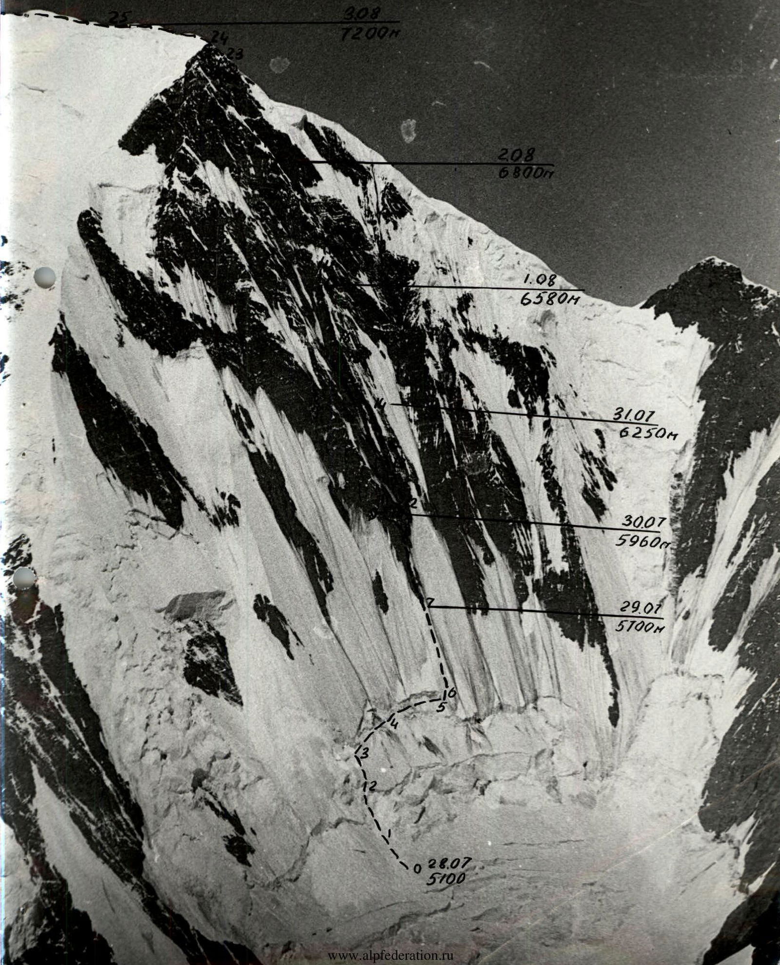
As a result of thorough and comprehensive study of the North-East face of Peak Kommunizma during observations from the Izvestiy Glacier and acclimatization ascents to Peaks Izvestiy (6840 m) and Pionerskaya Pravda (6550 m), the team concluded that the main working time on the face should begin no earlier than 15:00, when the face is in shadow, the ice hardens, and the intensity of rockfall decreases sharply. Based on this, the following tactical plan was outlined:
Day 1, Day 2 — Approach to the route Day 3 — Passage through the icefall to the upper bergschrund Day 4 — Passage along the ice slope to the rocks Days 5, 6, 7 — Passage through the middle part of the face along a weakly expressed counterfort to a height of 6600 m Days 8, 9 — Passage through the upper part of the face Day 10 — Ascent to the summit and descent via the "Abalakov" route Day 11 — Further descent to the base camp
During the passage of the face, there were two deviations from the tactical plan:
- As a result of preliminary processing of the lower icefall and high speed of movement, the night's stay in the bergschrund was skipped, saving one day;
- On the day of the ascent to the ridge, the departure from the night's stay was quite early, as it turned out that the upper right part of the face was not rockfall-prone.
 www.alpfederation.ru↗
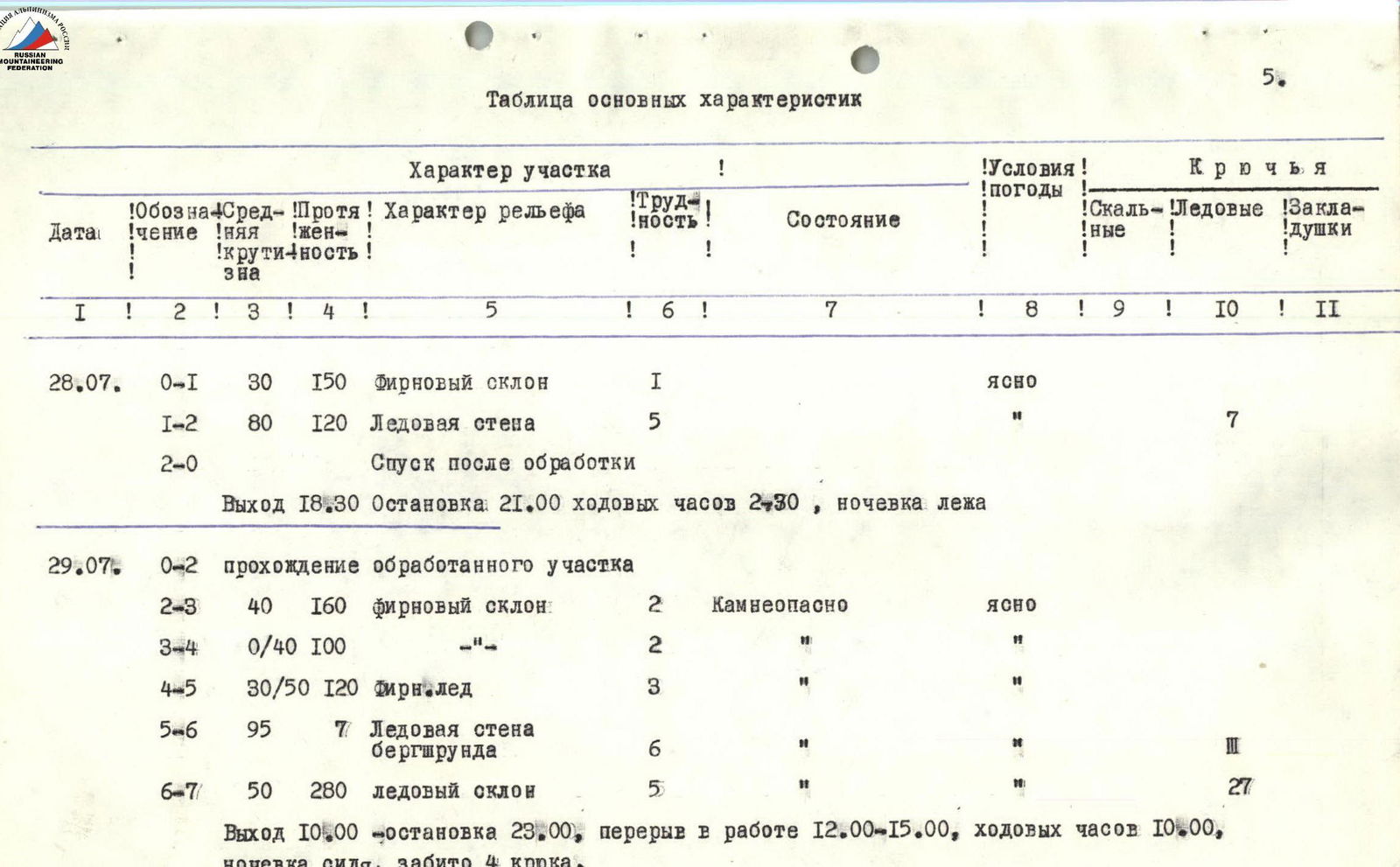
Table of Main Characteristics
| Date | Section | Average slope, ° | Length, m | Relief character | Category of difficulty of the section | Condition | Weather conditions | Rock pitons | Ice pitons | Chocks |
|---|---|---|---|---|---|---|---|---|---|---|
| 28.07. | R0–R1 | 30 | 150 | Firn slope | 1 | clear | ||||
| R1–R2 | 80 | 120 | Ice wall | 5 | 7 | |||||
| R2–R0 | Descent after processing | |||||||||
| Departure 18:30, stop 21:00, moving time 2 h 30 min, overnight stay lying down. | ||||||||||
| 29.07. | R0–R2 | Passage of the processed section | ||||||||
| R2–R3 | 40 | 160 | Firn slope | 2 | Rockfall-prone | clear | ||||
| R3–R4 | 0–40 | 100 | -"- | 2 | -"- | -"- | ||||
| R4–R5 | 30–50 | 120 | Firn-ice | 3 | -"- | -"- | III | |||
| R5–R6 | 95 | 7 | Ice wall of the bergschrund | 6 | -"- | -"- | ||||
| R6–R7 | 50 | 280 | Ice slope | 5 | -"- | -"- | 27 | |||
| Departure 10:00, stop 23:00, break in work 12:00–15:00, moving time 10 h, overnight stay sitting, 4 pitons hammered. | ||||||||||
| 30.07. | R7–R8 | 65 | 220 | Weakly expressed counterfort | 4 | Rockfall-prone, destroyed | clear | 12 | 17 | |
| R8–R9 | 45–85 | 60 | Diagonal chimney | 4 | Destroyed | * | 4 | |||
| R9–R10 | 0–90 | 30 | Wall | 6 | Rockfall-prone | * | 3 | 4 | ||
| R9–R10 | Return to overnight stay | |||||||||
| Departure at 16:00, stop at 27:00, moving time 3 h, overnight stay sitting, 3 pitons hammered. | ||||||||||
| 31.07. | R10–R11 | 80 | 20 | Internal corner | 5 | Rockfall-prone, destroyed, iced | clear | I | 2 | |
| R11–R12 | 0–40 | 80 | Base of the couloir | 3 | -"- | " | I | ledge | ||
| R12–R13 | 80 | 80 | Ascent on the counterfort | 5 | Destroyed upper part, iced | " | 7 | 8 | ||
| R13–R14 | 70 | 240 | Counterfort | 5 | Destroyed, rockfall-prone | Fog | 14 | 15 | ||
| Departure 15:00, stop 20:00, moving time 5 h, overnight stay sitting, 7 pitons hammered. | ||||||||||
| 01.08. | R14–R15 | 70 | 130 | Counterfort | 5 | Destroyed, rockfall-prone | Fog | 6 | 10 | |
| R15–R16 | 80 | 130 | Ascent on the counterfort | 5 | -"- | * | 2 | 3 | ||
| R16–R17 | 70 | 190 | Counterfort | 5 | At the end, ascents with ice ledges, rockfall-prone | * | 6 | 7 | 8 | |
| Departure 15:00, stop 19:00, moving time 4 h, overnight stay sitting, 5 pitons hammered. | ||||||||||
| 02.08. | R17–R18 | 70 | 40 | Counterfort | 4 | In the middle, an ice ledge, rockfall-prone | clear | 2 | 3 | |
| R18–R19 | 60 | 40 | Ice ledge | 4 | Rockfall-prone | * | 3 | |||
| R19–R20 | 90 | 60 | Wall | 6 | Iced monolith, upper part — rockfall-prone | * | 9 | 2 | ||
| R20–R21 | 70 | 100 | Ice ridges alternating with rock | 5 | Lower part rockfall-prone | * | I | 7 | 3 | |
| Departure 5:00, stop 9:00, moving time 4 h, overnight stay lying down. | ||||||||||
| 03.08. | R21–R22 | 70 | 220 | Ice ridges alternating with rock | 5 | * | 4 | 14 | 4 | |
| R22–R23 | 80 | 80 | Couloir | 5 | Iced | * | II | 2 | ||
| R23–R24 | 25 | 50 | Firn slope | 1 | * | |||||
| R24–R25 | 15 | 300 | Snow-firn ridge | 2 | * | |||||
| Departure 9:00, stop 19:00, moving time 10 h, overnight stay lying down. | ||||||||||
| 04.08. | R25–R26 | 15 | 1200 | Ridge snow-firn | 2 | strong wind | ||||
| Departure 9:00, arrival at the summit 14:30, moving time 5 h 30 min, slope angle 63°. | ||||||||||
| Length of the face 2600 m, pitons hammered: rock — 79, ice — 55, chocks — 85 for overnight stays. |
Explanation to the Table
On July 27, 1978, from the "4600" camp, we proceeded to the reconnaissance under the E. ridge of Peak Kommunizma.
On July 28, 1978, we ascended to the Izvestiy cirque, passed one step of the icefall, and set up a tent under a 100-meter slope on a firn slope (section R0–R1). The duo Putintsev, Gromov ascended to the slope (section R1–R2) along its destroyed left part. They climbed on the front teeth of crampons, with a specially sharpened piton in one hand and a similarly sharpened ice axe in the other. In the middle of the slope, they had to overcome two 5-meter negative sections. Having hung 120 m of rope, the duo descended for an overnight stay.
On July 29, 1978, at 10:00, the team departed from the overnight stay. They quickly passed the processed section, pulling up backpacks on the negative sections. The firn slope (section R2–R3) was climbed in turn, under observation, with continuous belay ropes stretched. Hiding in the bergschrund, they sat down to wait out the rockfall-prone time. At 15:00, they continued work. Traversing along the bergschrund (sections R3–R4; R4–R5), they approached the planned spot for its passage. Having worked on the ice wall of the bergschrund (section R5–R6), they reached the ice slope (section R6–R7), where they used the same technique as on section R1–R2. The presence of a piton, to which they were already attached, in one hand, and an ice axe in the other, allowed them to almost instantly secure themselves to the slope. They organized a sitting overnight stay on a pre-selected spot, already in the dark, by cutting the ice at the border between ice and rock. The Gromov, Putintsev duo worked ahead.
On July 30, 1978, the rocks start with an overhanging wall, under which we spent the night, then the steepness decreases, but the danger from occasionally flying stones increases, even in the second half of the day. Voronin moved ahead, the rest, having pulled up backpacks on the negative section, climbed on jumar clamps, thus ensuring continuous upper belay. In some places, the rope was additionally fixed on intermediate pitons. Having reached the end of the "tie" (section R7–R8), they saw a ledge to the left, to which a heavily destroyed diagonal crack led in the sheer wall (section R8–R9). Under the ledge, they began to lay out sitting platforms, and Putintsev proceeded to process; having traversed 30 m to the right (section R9–R10) along the sheer wall and having laid the rope under ledges to protect it from being cut, Putintsev returned. They spent the night and half of the next day under the ledge, with water dripping from above.
On July 31, 1978, having passed the processed section, they ascended along a very wide internal corner (section R10–R11) filled with ice to the left edge of the couloir, which ended in a wall at this spot. The couloir was rockfall-prone. They crossed it individually, almost running, ensuring observation (section R11–R12).
The right edge of the couloir starts with an almost sheer wall (section R12–R13) in its upper part, filled with ice. Along its right edge, Gromov ascended to a weakly expressed counterfort (section R13–R19), ending at a height of 6650 m. The nature of the work along the entire length of the counterfort was the same. Heavily destroyed rocks require very attentive passage. The high psychological load forced frequent changes of the person moving ahead.
At point R14, they settled in for an overnight stay, hanging their backpacks and sitting on them throughout the night.
On August 1, 1978, at the end of the day, on section R16–R17, the rocks were interrupted three times by 20-meter ice ledges. The technique of working on ice was the same as before. They spent the night again, sitting under a ledge at point R17.
On August 2, 1978, they continued on the same counterfort. In the middle of section R17–R18, there was another 20-meter ice ledge. The counterfort ends with an ice ledge (section R18–R19), resting against a sheer wall (section R19–R20), starting with a small cornice, which greatly complicated the transition to rocks in crampons, with no possibility of hammering a piton at the beginning of the rock section. On the transition, the rocks were destroyed. Above, the wall was quite monolithic, allowing Putintsev to quickly pass the section.
Kalinin and Voronin continued work, while the others began to pull up backpacks.
Further to the left, upwards, there is a series of ice and rock ridges and couloirs between the upper and lower sheer rock belts (section R20–R22).
Work proceeded in steps: vertically upwards along the ridge — traverse to the next one.
At point R21, under the protection of a sheer wall, having cut out a firn overhang, they finally organized a lying-down overnight stay.
On August 3, 1978, in the morning, it became clear that rocks were barely falling on our part of the face. They gathered, and Mulyukov began work. After a good night's rest, they moved quickly and within 3 hours ascended to the base of a weakly expressed zigzag-shaped couloir (section R22–R23), leading out to the ridge. The rocks were heavily iced.
Having worked on the couloir, Gromov reached a wide firn slope of the ridge (section R23–R24).
Then the pre-summit ridge of Peak Kommunizma begins (section R24–R26).
On August 4, 1978, having spent the night on a convenient platform, the team ascended along the ridge to the pre-summit, from where, leaving their backpacks, they continued the ascent light.
At 14:30, they reached the summit of Peak Kommunizma. On the same day, they descended along the E. ridge to 6400 m, and on the next day, they continued their descent.