Ascent Passport
- Ascent category — technical.
- Ascent area — Central Pamir, Vanch.
- Ascent route — Peak Kolesnik S.V. (height 5452 m above sea level) via the Southwest ridge.
- Ascent characteristics: Height difference — from overnight stay (3900 m) to the summit — 1550 m. Average steepness — 55°. Length of the complex section — 500 m.
- Pitons used: rock — 20, ice — 7, drill pitons — not used.
- Number of travel hours from overnight stay to the summit — 14:15.
- Number of overnight stays and their characteristics: a. Overnight stay on a rocky island behind the II waterfall — good, there's a site and water. b. Possible overnight stays on the ridge from Peak Snezhnij to Peak Kolesnik and on the summit of Peak Kolesnik (on snow).
- Team name — LOS DSO "Trud" gathering.
- Surname, name, patronymic of the leader, participants, and their qualification: leader — Gerzhberg Yuri Isakovich — 1st sports category, participants — Kiselev Albert Alexandrovich — 1st sports category, Popov Boris Alexeevich — 1st sports category, Seleznev Fedor Fadeevich — 1st sports category, Temirov Mukhamed Mukhamedovich — 1st sports category, Karozeev Alexander Nikolaevich — 2nd sports category.
- Team coach — MS (Master of Sports) Tunik Alfred Lvovich.
- Date of departure and return — from July 11 to July 13, 1979.
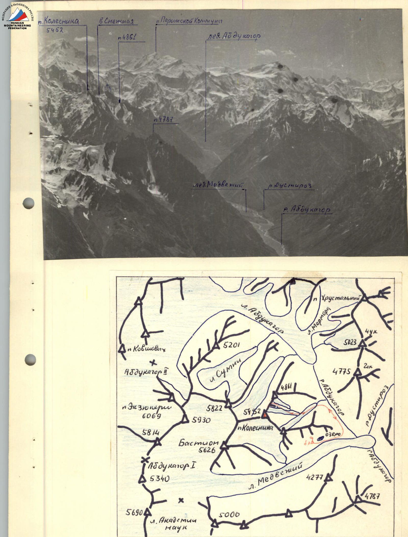
Panorama and map of the area of p. Kolesnik. Table of main characteristics of the ascent route to Peak Kolesnik. 4A category of complexity.
| № | Section | Average steepness | Length, m | Terrain characteristics | Difficulty | Condition | Weather conditions | Rock pitons | Ice pitons | Drill pitons |
|---|---|---|---|---|---|---|---|---|---|---|
| 1 | R0–R1 | 35° | 800 | Glacier, deep snow, avalanche tracks | 3 | satisfactory | good | – | – | – |
| 2 | R1–R2 | 50° | 200 | Chimney ice-rock | 4 | destroyed | – | 3 | 2 | – |
| 3 | R2–R3 | 35° | 400 | Ridge to Peak Snezhnij ice-snow-rock | 3 | good | – | 1 | 3 | – |
| 4 | R3–R4 | 20° | 600 | Ridge from Snezhnij to Kolesnik rock-snow | 4 | cornices | – | – | – | – |
| 5 | R4–R5 | 75° | 60 | Chimney rock | 5 | monolith | – | 6 | – | – |
| 6 | R5–R6 | 65° | 40 | Wall ice | 5 | bare ice | – | – | 2 | – |
| 7 | R6–R7 | 80° | 35 | Wall rock | 4 | destroyed | – | 3 | – | – |
| 8 | R7–R8 | 80° | 80 | Chimney rock-ice | 5 | monolith iced | – | 7 | – | – |
| 9 | R8–R9 | 50° | 350 | Ridge snow-rock | 4 | cornices | good | – | – | – |
The group of first ascenders — climbers from LOS DSO "Trud" — decided to name the unnamed peak with a height of 5452 m after academician S.V. Kolesnik — the founder of Soviet glaciology, president of the Geographical Society of the USSR, in commemoration of his merits in the development of Soviet geographical science and in honor of his eightieth birthday.
The ascent from July 10 to July 13, 1979, was made by a group from the Leningrad Regional Council of DSO "Trud" gathering consisting of:
- Gerzhberg Yu.I. — 1st sports category — leader
- Kiselev A.A. — 1st sports category
- Popov B.A. — 1st sports category
- Seleznev F.F. — 1st sports category
- Temirov M.M. — 1st sports category
- Karozeev A.N. — 2nd sports category
Peak Kolesnik (5452 m) is located in the Central Pamir in the western spur of the Academy of Sciences range, which divides the valleys of the Medvezhiy glacier, the Abdukagor river, and the Sumni glacier (see orographic diagram and photo 1). Peak Bastion (5626 m) is also located in this spur. When moving along the left (upstream) side of the Abdukagor river valley, the first stream (after the Medvezhiy glacier) flows out of the cirque of Peak Kolesnik, fed by glaciers in this cirque. The cirque is steep; the grassy slopes have a steepness of up to 45°. The most optimal ascent path is along the glacier. Approximately an hour's ascent along the glacier is interrupted by a continuous transverse crevasse. The crevasse is overcome on the right — a 20 m rappel down into it and then an ascent up the rocks. (Piton belay).
Overnight stays are located within 2 hours' ascent from the crevasse behind the second (to the right upstream) waterfall on a rocky island dividing the glaciers in the cirque Peak Kolesnik — Peak Snezhnij — Peak 4861 m and the cirque Peak Kolesnik — Peak Medvezhiy. There are ready-made sites and water available. R0–R1 From the overnight stay, ascend up the rocks (10 m) to the moraine of the right (upstream) glacier, and then to the glacier in the direction of the black rocky triangle, which is the beginning of the counterfort leading to Peak Snezhnaya. R1–R2 The black triangle is bypassed on the right. Behind it, a steep ice-rock couloir is visible, leading out onto the ridge of the counterfort. The steepness of the couloir is 45°. Length 200 m (ice and rock pitons. The couloir is prone to rockfall). R2–R3 The ridge of the counterfort is snowy with 5 steep ice-rock ascents of 40–60 m (ice and rock pitons).
The final ascent leads under the rocks of Peak Snezhnaya. The bergschrund is overcome via snow bridges.
The summit tower is bypassed on the left, and 150 m from it, after a sharp snow ridge, there is a small snow site with a large black rock standing in the middle. A good spot for an overnight stay. 5–6 hours from the initial overnight stay.
R3–R4 From the site to Peak Kolesnik leads a sharp rocky ridge, abounding in snow cornices (photo 2), formed by wind-blown snow. At first, the ridge goes up to a large snowy, and then rocky gendarme. On the rocky gendarme, there's a control cairn. From the control cairn, the ridge leads to a snowy saddle under the rocky tower of Peak Kolesnik.
The time taken to traverse the ridge is 2–2.5 hours. R4–R5 From the saddle to the summit tower leads a narrow steep chimney 60 m long. There are 2 rock jams in the chimney (piton belay) (photo 3). R5–R7 The chimney leads to a small ledge, from which a steep ice ascent begins — steepness 60–75°, length 40 m. In the upper part, the ice is covered with snow (ice pitons). From the ledge, a saddle is visible in the ridge of the counterfort, branching off from the summit ridge. One needs to move towards this saddle along a steep — 80–85° — strongly destroyed wall. The height of the wall is 35 m. One needs to move cautiously, as rocks from the wall fall onto the ledge. R7–R8 From the saddle, movement continues to the left along a steep (75–80°) rocky chimney. The bottom of the chimney is covered with ice. Length of the chimney is 80 m. Piton belay. Key location. R8–R9 The chimney leads to the summit ridge. The ridge is rocky-snowy, steep. There are two vertical ascents of 25–30 m on the ridge. Cornices. Before the summit, there's a good site where an overnight stay is possible.
The summit is a rocky tower 30 m high. The rocks are straightforward. There's a cairn on the rocks. From the saddle to the summit — 6–7 hours.
Descent from the summit — via the ascent route. Descent from the saddle straight down the snowy couloir is not recommended, as it is highly prone to rockfall — hit by rocks from the summit tower and the strongly destroyed ridge to Peak Snezhnij.
June 14–16, 1979, a repeat ascent to Peak Kolesnik via the Southwest ridge was made by a group from our gathering consisting of:
- Panurin V.P. — 2nd sports category, leader
- Vizaiger S.A. — CMS (Candidate for Master of Sports)
- Shevtsov S.E. — 2nd sports category
- Belyaev M.B. — 2nd sports category
- Kuznetsov E.V. — 2nd sports category
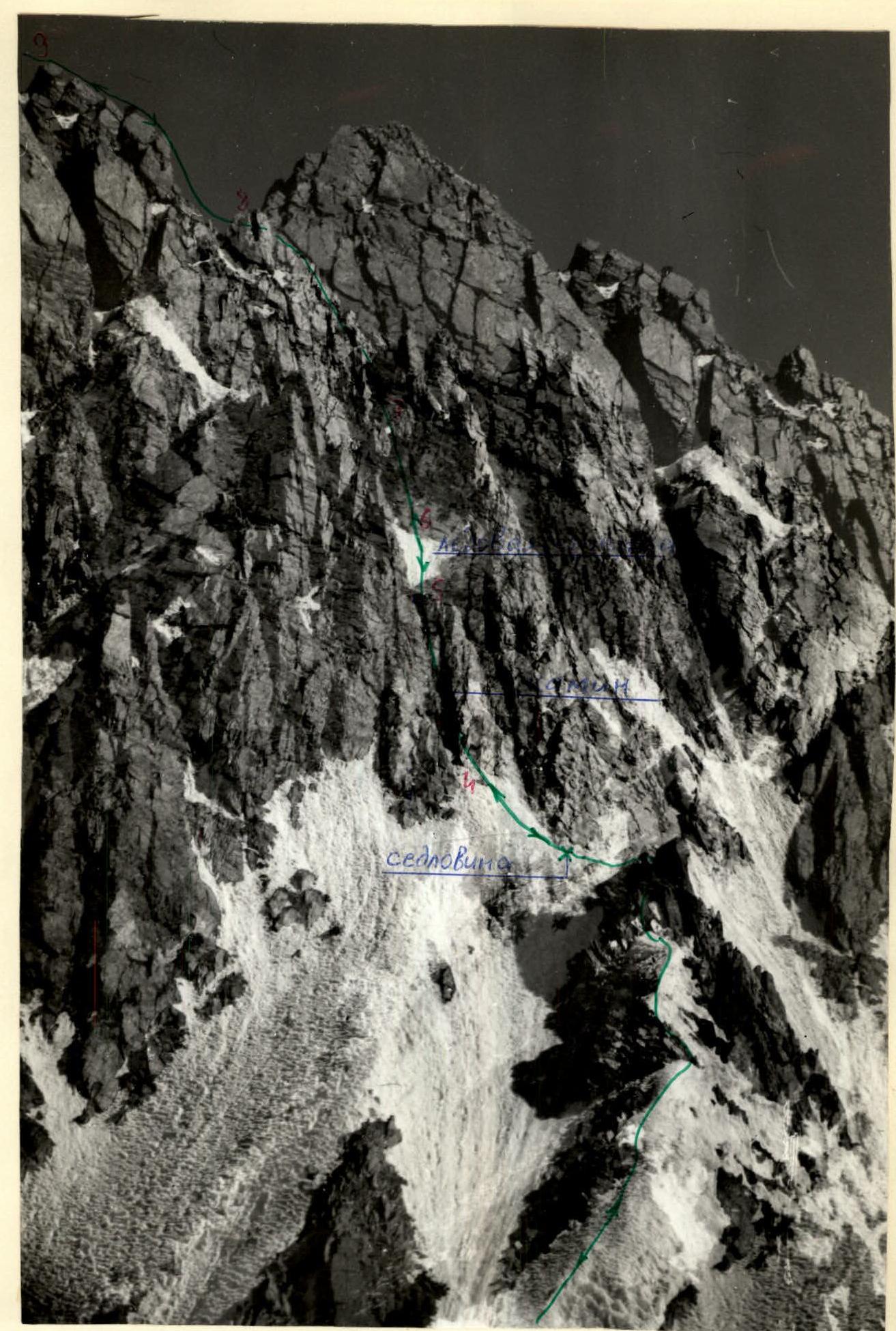
Photo 3. Start of the route to the summit tower. Sections R4–R8.
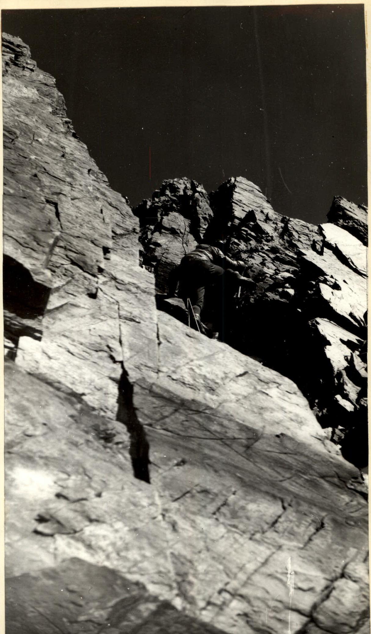
Photo 4. Passing the II jam in the chimney starting from the saddle (section R4–R5).