24
REPORT
on the ascent to Peak Kalinina (6565 m) (first ascent) by the special group "Nurek" of CS SDSO "Burevestnik"
| leader: | Kuzmin K.K. | — 3rd sports category USSR |
|---|---|---|
| members: | Bozhukov V.M. | — Master of Sports USSR |
| Vanin V.V. | — Master of Sports USSR | |
| Kosmachov O.S. | — Master of Sports USSR |
–1972–
BRIEF GEOGRAPHICAL INFORMATION
Peak Kalinina (6565 m) is located in a spur of the Peter I ridge. From the side of Peak Kommunizma, its neighbor is Peak Akhmat Doniša (6665 m). They are connected by a ridge at an altitude of 5600 m, from which:
- the Odinnadtsati Glacier begins towards the Bivachny Glacier;
- steep walls descend towards the Ayu-Jilga Glacier.
Our group, at the suggestion of K.K. Kuzmin, decided to climb Peak Kalinina — the highest unclimbed peak in the Union at that time. As the first route, the path from the 5600 m ridge seemed the simplest. True, the exit to it was doubtful, but this only strengthened the interest in the route.
ASCENT LOG
August 2. The expedition's base camp was located on the right moraine of the Bivachny Glacier, opposite the slopes of Peak Krasnoy Armii, below the lake. The approaches to Peak Kalinina took 5 hours of walking light (a cache had been made the day before).
August 3. We left the camp at 11:00. Before us were the two steps of a mighty icefall, above which was the smooth arc of the 5600 m ridge. After an hour, we approach a huge snowy couloir to the right of the icefall. We begin to move along its left side, sticking to the rocks. The snow is dense, with ice visible in places underneath. The steepness gradually increases. We move under the cover of rocks all the time. Belays are made using rock outcrops or via an ice axe in the snow. We pass 600 m this way. Finally, we turn onto the rocks to the left. The rocks are not difficult. We reach a small shoulder — a very convenient and safe place to bivouac. The first step of the icefall is visible on the left and already a bit below. We decide to bivouac here.
August 4. We set out at 6:00. The path goes left and upwards. The snow-ice slope is 60° steep with embedded rocks. Belays are made using ice screw anchors. We pass 300 m this way, gaining 80 m in height (section 4).
We emerge onto a huge snow-ice slope. The steepness is 40°. The slope is sunlit. The snow begins to soften. Small avalanches start. With each hour, they grow, and their tempo increases. Individual rocks fall. They are visible from afar. We constantly observe the upper part. About 500 m of dangerous traverse with a slight gain in height follows. Belays are made using ice anchors. We move in pairs: Kuzmin–Bozhukov, Kosmachov–Vanin.
Finally, we leave the slope and enter the icefall. The usual chaos of crevasses, seracs, walls up and down, cracks, etc. ensues. At 16:30, we emerge from the endless labyrinth of the icefall onto the ridge. It turns out that it has enormous dimensions — more than 1 km of horizontal terrain. From here, the route that goes along the left side of the slopes descending to the ridge seems simpler, not the one nearest to us.
August 5. We rise at 4:00 AM. We leave at 5:15. It's dark, with stars, but the weather is deteriorating. We traverse the ridge for 1.5 km. A noticeable descent begins. We sharply turn to the right and start the ascent. The snow slope is 35°–45° with an unstable crust. The steepness increases. There's an alternation of destroyed rocks with snowy slopes. The rocks are mostly simple, with some small walls. The snow is varied: sometimes loose, sometimes an unstable crust, sometimes firm crust convenient for crampons.
Gradually, the route becomes ridge-like in character. Again, we encounter small walls. We reach the summit at 12:30. There's a very strong wind. It's cloudy. Peak E. Korzhenevskoi is visible in the breaks of the clouds.
The descent along the ascent route to the ridge to the tent took 4 hours. August 6. We set out at 5:00. The sun illuminates the icefall early. By 10:00, we descended to the bivouac below the first step of the icefall. Two hours later, we were on the Odinnadtsati Glacier.
RECOMMENDATIONS FOR CLIMBERS
The first step of the icefall is bypassed to the right via rocks or a snowy couloir. Crossing the slope to the second step of the icefall is objectively dangerous. At night and early in the morning, rocks fall; during the day, avalanches occur. One must proceed very cautiously and attentively, constantly observing the upper part.
CONCLUSION ABOUT THE ROUTE
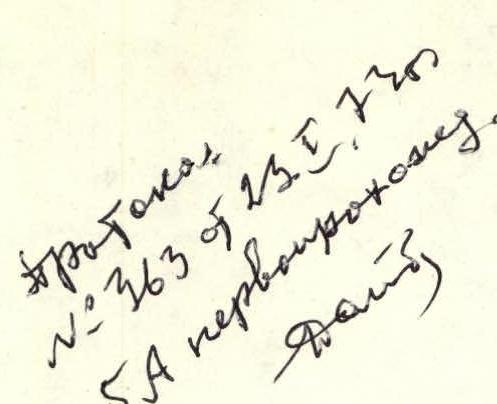
The ascent leader and all participants consider that the route can be classified as category 5A.
Group leader Participants
- (K.K. Kuzmin)
- (V.M. Bozhukov)
- (V.V. Vanin)
- (O.S. Kosmachov)
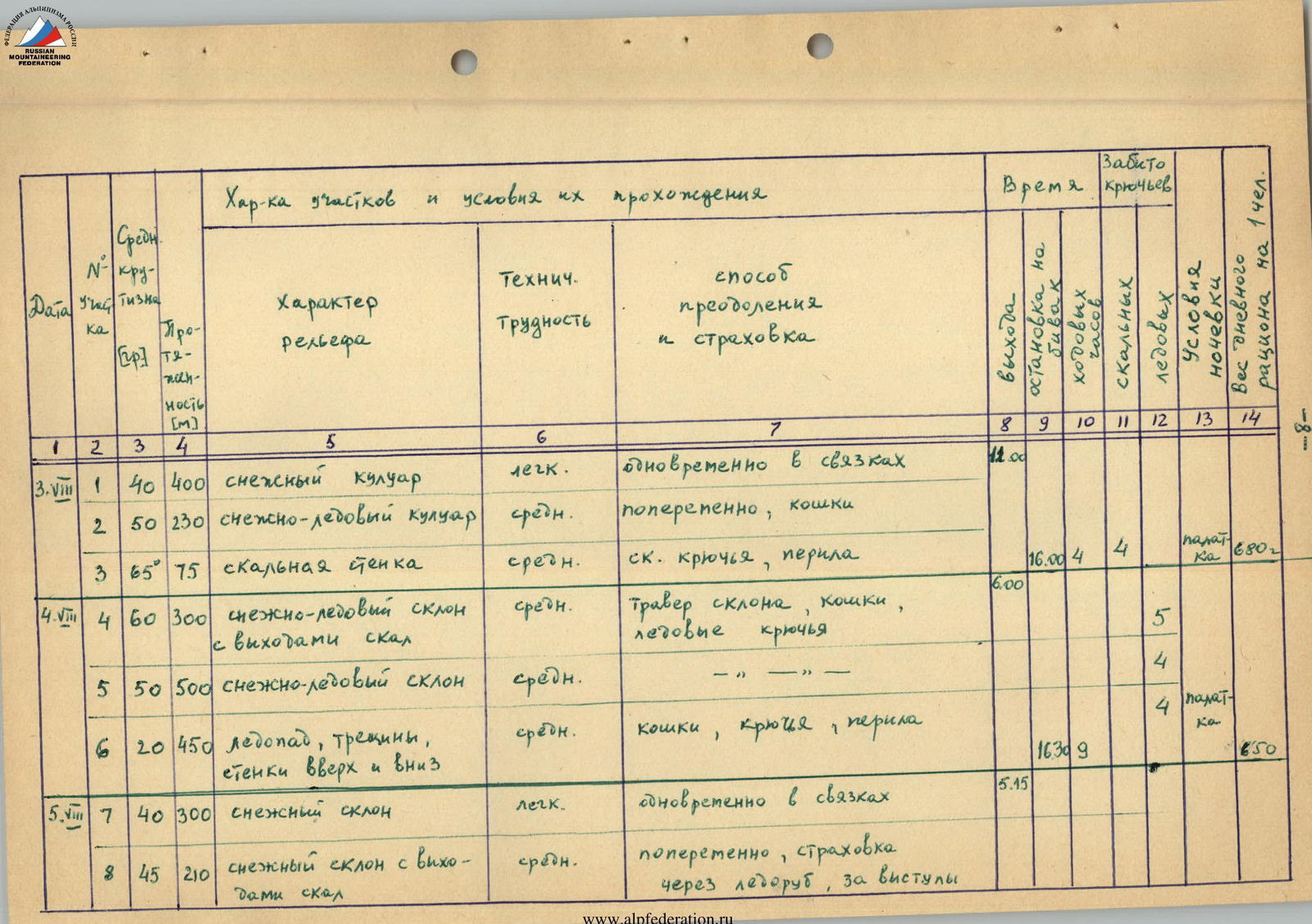
Characteristics of sections and conditions of passage
| Date | № | Steepness, ° | Length, m | Character of terrain | Technical difficulty | Method of overcoming and belaying | Time of departure | Time of stopping for bivouac | Number of rock anchors driven | Number of ice anchors driven | Bivouac conditions | Weight of daily ration, g |
|---|---|---|---|---|---|---|---|---|---|---|---|---|
| August 3 | R1 | 40 | 400 | snowy couloir | 1 | simultaneously in pairs | 12:00 | |||||
| R2 | 50 | 230 | snow-ice couloir | 2 | alternately, crampons | |||||||
| R3 | 65 | 75 | rocky wall | 2 | rock anchors, fixed ropes | 16:00 | 4 | 4 | tent | 680 | ||
| August 4 | R4 | 60 | 300 | snow-ice slope with rock outcrops | 2 | traverse of slope, crampons, ice anchors | 6:00 | 5 | ||||
| R5 | 50 | 500 | snow-ice slope | 2 | — | |||||||
| R6 | 20 | 450 | icefall, crevasses, walls | 2 | crampons, anchors, fixed ropes | 16:30 | 9 | 650 | ||||
| August 5 | R7 | 40 | 300 | snowy slope | 1 | simultaneously in pairs | 5:15 | |||||
| R8 | 45 | 210 | snowy slope with rock outcrops | 2 | alternately, belay via ice axe, rock outcrops | |||||||
| R9 | 40 | 260 | snowy slope | 2 | alternately, belay via ice axe | |||||||
| R10 | 50 | 210 | rocky-snowy ridge | 2 | alternately, belay via rock outcrops | |||||||
| R11 | 65 | 15 | rocky wall | 3 | anchors, fixed ropes | 3 | ||||||
| R12 | 45 | 190 | snowy ridge with rock outcrops | 2 | alternately, belay via rock outcrops | |||||||
| R13 | 45 | 160 | rocky ridge | 2 | — | |||||||
| R14 | 30 | 250 | snowy-rocky ridge | 2 | simultaneously in pairs | 16:30 | 10 | tent | 600 |
At the summit of p. Kalinina.


