Report
On the first ascent of Peak 6128 m (p. Dnipropetrovsk) on the Central Pamir by the team from Dnipropetrovsk on Silver 4B, led by V. Shabokhin
1. Geographical description, sporting characteristics of Peak 6128 m. Description of climbing conditions.
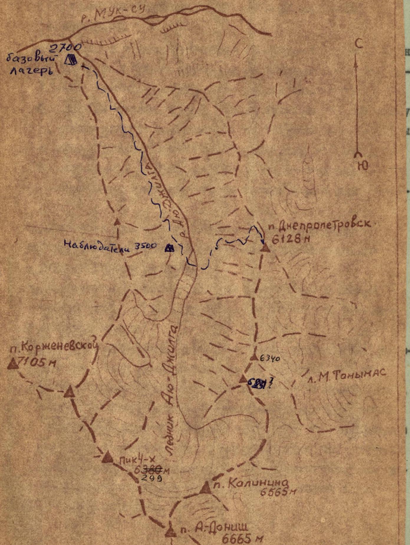
Peak 6128 m is located in the northern part of the Academy of Sciences range, slightly south of its division into two ranges:
- the eastern branch towards the peaks Muzdiilga, Sandal, Shilbe;
- the northern branch towards the Muksu River between the Aiu-Dzhilga and Barubesh glaciers.
The northern branch of the range after Peak 6128 m drops sharply. The height of the peaks in the ridge is no more than 5200 m.
The eastern slope of Peak 6128 m is ice-snowy, steeply breaking off towards the Barubesh and M. Tanymas glaciers.
The western slope of Peak 6128 m consists of a large number of rocky counterforts and snow-ice couloirs, feeding the Aiu-Dzhilga River (see photo).
The rocks composing the massif of Peak 6128 m are very diverse. The alternation of granites, marble belts, sandstones, and shales creates a particularly technical complexity for the passage of routes to this peak. The presence of sandstones and shales in the upper part of the peak, covered with ice and snow, creates additional difficulties in organizing belays and self-belays.
The prevailing northwestern winds in this area form cornices hanging towards the M. Tanymas glacier, which complicates the passage of routes along the northern and southern ridges.
The first mountaineering expedition to the Aiu-Dzhilga glacier appeared in 1966–1967. Participants of the expedition from the Leningrad Regional Council of the Spartak Sports Society led by P. Budanov made a number of ascents in the upper reaches of the glacier, and passed a number of routes to:
- Peak Chetyrekh,
- Peak Akhmadi-Donisha,
- Peak 6231 m (Peak Yakira).
Then, in 1969, Dnipropetrovsk climbers explored the gorge with the Walter glacier through the 5500 m col with the aim of reconnaissance and selection of future climbing objects.
On the eastern slopes of the Academy of Sciences range during the period of intense melting (July — early August), increased rockfall and avalanche danger is observed, which poses complex tasks for climbers to optimally choose a route and climbing tactics to ensure group safety.
Technically, along the western slopes of Peak 6128 m, along the counterforts, a number of technically complex and logical routes can be laid out, the passage of which requires the application of most elements of mountaineering technique and good moral and physical preparation of athletes.
The Aiu-Dzhilga gorge area is characterized by unstable weather, strong winds, a large amount of snow falling in winter, and large daily temperature fluctuations, which also affects the regime of the Aiu-Dzhilga River. Movement along the Aiu-Dzhilga River is advisable only on one side of the gorge, as crossing the river is possible only in its middle part in the early morning hours. In the upper part, the river is compressed by the sheer walls of the canyon. The most optimal path to the upper reaches is along the left bank of the river, bypassing the canyon along the slopes of the northern spur of the Peter the Great Range.
The expedition's base camp was located on the left bank of the Aiu-Dzhilga River, slightly above its confluence with the Muk-Su River at an altitude of 2700 m.
The observation group was located on the left bank of the river in an intermediate camp at 3500 m, where communication was maintained with the assault group and the base camp.
Map-scheme of the Aiu-Dzhilga glacier area
The tactical plan for the ascent provided for the passage of the route in 6 days.
The reconnaissance results showed that the most challenging part of the route would be its beginning, representing a steep wall leading to the northern edge, as well as the passage of the edge, abundant with snow cornices. At the same time, the chosen route was completely safe.
Great attention was paid to this issue. All special equipment (duralumin carabiners, wedges, rock pitons, ice screws) were tested in the laboratory of the Department of Elasticity Theory at the State University, including:
- duralumin carabiners,
- wedges,
- rock pitons,
- ice screws.
The group had regular communication with observers. The observation group conducted visual control using a 60x telescope.
During the pre-season preparation and in the mountains, the expedition doctor systematically monitored the health status and physical data of each athlete.
The team on the ascent had a first-aid kit with a necessary set of medications. All team members equally mastered the necessary techniques for providing medical assistance.
The team had a stock of food for 7 days (at the rate of 600–650 grams per person per day). The selection of products ensured their necessary caloric content and good taste qualities.
4. Composition of the assault group and observation group.
| № | Full Name | Year of birth | Nationality | Sports rank | Education | Home address |
|---|---|---|---|---|---|---|
| Assault group | ||||||
| 1 | Shabokhin Viktor Alekseevich — leader | 1939 | Russian | Master of Sports | Higher | Dnipropetrovsk, Mostova Street, 6/10 |
| 2 | Vyshinsky Valery Trofimovich | 1941 | Ukrainian | Candidate for Master of Sports | Higher | Dnipropetrovsk, General Pushkin Street, 16, apt. 8 |
| 3 | Grebenkin Vitaly Artemovich | 1934 | Russian | Candidate for Master of Sports | Higher | Dnipropetrovsk, Kirov Avenue, 90, apt. 3 |
| 4 | Suslov Viktor Ivanovich | 1932 | Russian | Candidate for Master of Sports | Higher | Dnipropetrovsk, Zamistkova Street, 8, apt. 75 |
| Observation group | ||||||
| 1 | Petrichenko Nikolai Nikolaevich | 1944 | Ukrainian | Candidate for Master of Sports | Higher | Dnipropetrovsk, Novofrunzenska Street, 20, apt. 1 |
| 2 | Lyashenko Alexey Mikhailovich | 1947 | Ukrainian | Candidate for Master of Sports | Higher | Dnipropetrovsk region, Krinichansky district, Vetrovka village |
5. Description of the ascent.
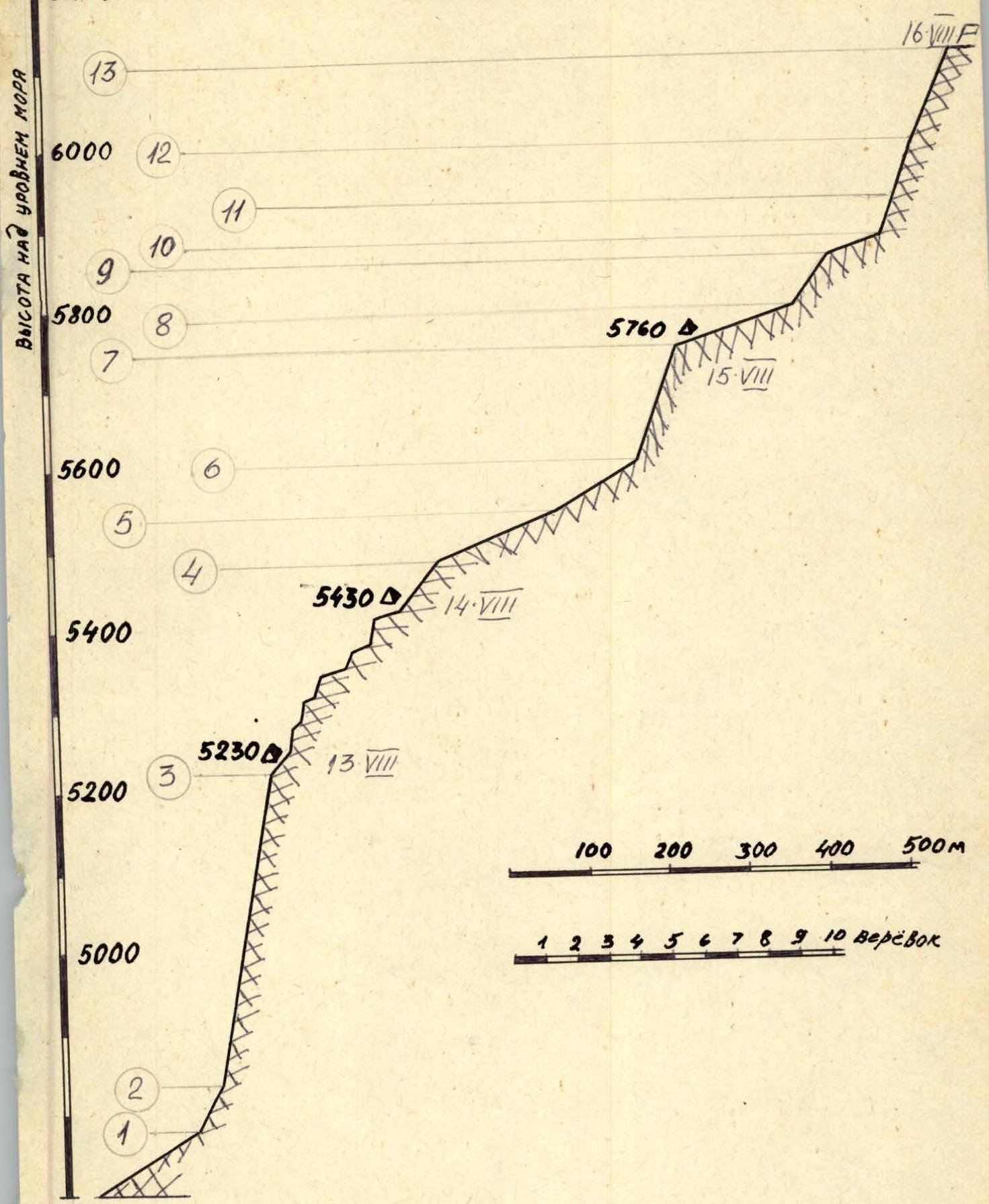
August 12. The assault group left the camp and on the same day ascended to the beginning of the route. They stopped for the night on the glacier at 4700 m.
August 13. Considering the length of the first section of the route, they started early, at 6:00 am. Initially on snow, then on ice (40–45°), they reached a rocky outcrop, which directly leads to the wall. The wall is a large-block wall with heights of 15–20 meters, interspersed with narrow (20–30 cm) scree shelves with complex climbing. In some places (3 times), ladders were used to pass the most difficult sections. Pitons were used for belays. The first climber went without a backpack, then descended for it. The others followed along the fixed rope. For the day, they covered 1.5 ropes on ice and 10 ropes on rocks. They stopped for the night around 18:00. The platform was made of stones on a scree shelf.
August 14. Departure at 9:00. The slope becomes gentler. The rocks go in steps. Steep (60–80°) rocks alternate with inclined shelves up to 30–40 m long and 20–40° steep. Belays were made using pitons and rock features. In the second half of the day, the weather deteriorated sharply, and it started snowing. Visibility was lost. They stopped around 15:00. The platform was organized in a relatively convenient and safe place at the beginning of an inclined shelf.
August 15. Although the route was shrouded in fog in the morning, the pair Suslov — Vyshinsky went out lightly for reconnaissance and, having passed 2 ropes on rocks, reported that the route was visible further and they could continue. Therefore, the entire group continued the route at 12:00. The weather started to improve.
Further movement:
- Approximately 7 ropes on snow, which does not present great difficulties but requires careful route selection due to the abundance of cornices.
- To the left, the northern edge drops steeply down.
- Small avalanches of fresh snow often occur on the slope.
- Moving to the right, we reach complex rocks with snow-covered shelves.
Having passed 4 ropes, they stopped for the night in a snow depression. Although the path further is clear, further movement is not advisable due to the slushy snow and abundance of cornices ahead.
August 16. They departed very early, at 6:30 am, as they planned to reach the summit and return for the night on this day. The weather is excellent. Nevertheless, they took sleeping bags and a primus stove with them. Along a relatively easy ridge, they approached a steep snow board. The snow is very dry. They had to literally dig trenches. Ice appears in the upper part; they cut steps. After a bend, they again reached a sharp snow ridge and, after 2 ropes, approached a steep ice slope covered with a thin layer of snow. Since the snow is very dry, they had to dig trenches again in the lower part of the ice wall to reach the ice; further — cutting steps. The ice wall turns into a steep (up to 80°) large-block wall with many "live" stones sprinkled with snow. After 2 ropes passed with thorough belays, confidence grew that the summit was near. Indeed, passing another 3 ropes on less steep (up to 60°) rocks with ice accretion, they emerged slightly below the summit onto rocky slabs. From the summit point to the left, a mighty cornice hangs. Further, the ridge drops steeply down. Time — 2 hours 30 minutes. We are on the summit! They made final film footage on the summit. On one of the slabs, they fixed an emblem of Dnipropetrovsk with pitons. In the summit cairn, they left commemorative pennants with text stating that in honor of the 200th anniversary of Dnipropetrovsk, they named the peak "p. Dnipropetrovsk" by right of first ascenders. They descended along the ascent route to the tent at 5760 m.
August 17. Continuing the descent along the northern ridge, they returned to the camp by evening.
The ascent is completed.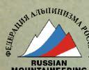
6. Table of main route characteristics
The route to Peak 6128 m (p. Dnipropetrovsk) via the northern edge. The height difference of the route is 1430 m, including the most complex sections (5A, 5B category of difficulty) — 1200 m. The average steepness of the route is 40°. The steepness of the most complex sections is 60–80°.
| № | Date | Section length | Average steepness of the section | Section length in meters | Characteristics of sections and conditions of their passage | Time | Pitons driven | Conditions | | : | :------- | :----------------- | :----------------------- | :-------------------------------------- | :--------------------------------------------------------------------------------------------------------------------------------------- | :---- | :------------- | :----------- | | | | | | | By relief character | By method of overcoming and belaying | | | overnight stay | | 1 | 13.VIII | 1 | 30° | 160 m | Snow slope, colgas | Simultaneous movement | 2A | | 6:00 | | 2 | | 2 | 45° | 60 m | Ice slope | Ice, pitons, crampons, passage partially on front points, step cutting | 4A | 6 | | | 3 | | 3 | 80° | 400 m | Rocky large-block destroyed wall with short (20–30 m) vertical walls. Rocks with diverse relief: inner corners, walls, chimneys, slabs. In the upper part, rocks are covered with ice accretion and snow. 35–48. | Pitons, 150–180 m, 220 m | 5B | 18 rock, 12 ice | Cloudy. Platform made of stones on an inclined shelf | | 4 | 14.VIII | 4 | 20–80° | 340 m | The character of the route is the same as on section 3. More snow-covered rocks and more inclined slabs; more rugged route. | Pitons belaying, rock features | 5A | 15 rock, 6 ice | Clear, cloudy, snowfall. Platform made of stones on a scree shelf. | | 5 | 15.VIII | 5 | 20° | 160 m | Snow, movement along a cornice | Belaying through an ice axe | 2A | | Cloudy, 12. | | 6 | | 6 | 30° | 120 m | Snow on ice | Belaying through an ice axe, ice, pitons | 2 | 3 | | | 7 | | 7 | 70° | 160 m | Large-block wall. The character of the rocks is similar to section 3. Rocks are heavily snow-covered. | Ice pitons | 5 | 18 rock, 30 ice | Overnight stay in a snow depression | | 8 | 16.VIII | 8 | 15° | 180 m | Snow ridge with cornices | Ice axe | 2B | | 6:30 |

| № | Date | Section length | Average steepness of the section | Section length in meters | Characteristics of sections and conditions of their passage | Time | Pitons driven | Conditions | | : | :--- | :----------------- | :----------------------- | :-------------------------------------- | :---------------------------------------------------------------------- | :---- | :------------- | :------ | | | | | | | By relief character | By method of overcoming and belaying | | | overnight stay | | 9 | | 9 | 60° | 80 m | Snow slope, in the upper part ice outcrops | Ice axe, ice pitons | 5A | 2 | | | 10 | | 10 | 15° | 80 m | Snow ridge with cornices | Ice axe | 2B | | | | 11 | | 11 | 60° | 60 m | Ice slope, covered with snow | Ice pitons, in the lower part ice axe, trench, step cutting. | 5B | 7 | | | 12 | | 12 | 80° | 40 m | Large-block destroyed rocks with ice accretion | Pitons | 5B | 12 | | | | | | 80° | 40 m | | 5A | | | | 13 | | 13 | 60° | 120 m | Destroyed ridge with individual 5–10-meter walls with ice accretion. | Pitons | 5A | 9 | |
Reaching the summit of Peak 6128 m — 14:30.
Team captain and coach — Master of Sports of the USSR V. Shabokhin
8. Conclusions
- The team members successfully coped with the task. The even technical and physical preparation of the team allowed for an even distribution of the load among the participants. The route was completed without deviations from the planned tactical plan, without injuries, and without loss of equipment.
- The route to Peak 6128 m (p. Dnipropetrovsk) — is a very logical and objectively safe route. The total height difference is 1430 m, including the most complex sections (5A, 5B category of difficulty) — 1200 m. The steepness of the most complex sections is 60–80°, with some rocky sections being vertical; the average steepness of the route is 40°.
During the passage of the route, 99 rock and 18 ice pitons were driven. The route was completed in 33 hours of climbing time.
- Comparison of this route with other routes previously passed by the team, as well as its objective characteristics, allows us to classify the ascent as a route of 5B category of difficulty.
Team captain and coach — Master of Sports of the USSR V. Shabokhin