Moscow City Council of the Spartak Voluntary Sports Society
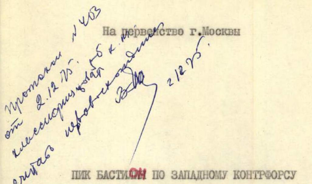
Peak Bastilia via the western counterfort and the edge of the northern wall (first ascent)
5B category of difficulty
Team captain: Master of Sports Pissulov D.B. Team coaches:
- Master of Sports of International Class Kovtunenko V.D.
- Master of Sports Martynovsky A.A.
1975
Area diagram

I. Brief geographical description of the area
Peak Bastilia (5400 m) is located in a small spur of the Academy of Sciences ridge, separating the basins of the Medvezhiy and Abductor glaciers in the Central Pamir.
Territorially:
- Tajik SSR
- Gorno-Badakhshan Autonomous Region
- Vanchsky District
The steep northern walls of Peak Bastilia are washed by the upper reaches of the Medvezhiy Glacier. The remaining slopes are gentle and form the firn field of the left tributary of the Fedchenko Glacier.
To the west, along the Abductor River to the geologists' settlement Dalniy, there is a good passenger road, making the Vanch region easily accessible from both the city of Khorog, Tajik SSR, and the city of Osh, Kyrgyz SSR.
At the fork of the Abductor and Geographical Society valleys, a tent camp " Vysotnik" has been operating for the second year.
Almost all the peaks in the region are composed of heavily destroyed schists and sandstones, местами with traces of volcanic activity (granites, granodiorites, tuffs). The climate in the region is quite stable, however, sharp fluctuations in daily temperature (from +20 °C during the day to −10 °C in the evening) significantly complicate ascents to peaks above 5 thousand meters.
In sports terms, the Vanch region is very interesting. Here are located such well-known peaks as:
- Peak Revolyutsii,
- Peak Kommunisticheskoi Akademii,
- Peak 26-ti Baku Commissars.
And possibly, it is the presence of these popular peaks, attracting the attention of many mountaineering expeditions, that explains the fact that there are many mountains in the region whose peaks have not yet been trodden by humans. For example, in the circus, which has earned a bad reputation due to the movements of the Medvezhiy Glacier, there is not a single conquered peak.
II. Composition of the team. Organizational and tactical plans. Equipment.
The team that made the ascent was part of the training camp of the Moscow City Council of the Spartak Voluntary Sports Society, held on the basis of the Vysotnik camp. The team included:
- Master of Sports Piskulov D. — captain
- Bechkurov V. — 1st sports category
- Ivanov N. — 1st sports category
- Korovkin O. — Candidate for Master of Sports
The team members have been climbing together for many years and have experience in high-altitude and glacier ascents (p. Khan-Tengri, p. Engelsa, Dalar Dvoynashka, etc.).
The team was preparing for the ascent of this difficulty throughout the year. Long-term cross-country running, climbing on the Tsaritsyno rock climbing wall and on the perches in Dolgoprudny allowed the team members to quickly acquire good physical fitness. In May, a training camp was held on the basis of the Dgoba camp for the team members, during which some technical aspects were practiced:
- testing new special equipment;
- conducting training ascents.
The base camp of the expedition was located in the left (orographic) pocket of the moraine of the Medvezhiy Glacier. On a small moraine island, a 4-5 hour walk from the glacier, a storm camp was set up, from which observations were made of the intended route.
The tactics of the assault were built on the basis of specific conditions that developed by the time of the ascent, taking into account:
- first ascent,
- complexity,
- height and duration of the route,
- strength and condition of the team,
- availability of equipment,
- reconnaissance and preliminary preparation of the route,
- weather,
- interaction with the observation group.
At the same time, the main attention was paid to the safety of the route.
Before the ascent, a reconnaissance of the descent route was carried out (the ice fall of the Abductor I pass).
On the ascent:
- All the most difficult sections were climbed without backpacks.
- The first climber climbed these sections in lightweight Vibram shoes.
- The weight of each backpack was 18 kg.
- The set of products was high-calorie, at the rate of 600 g per day per person.
The team's equipment:
- Domestic: special and standard equipment.
- Imported: Vibram, crampons, and rope.
- All pitons met the strength standards adopted in the recommendations of the USSR Mountaineering Federation.
- 95% of the equipment was specially manufactured using lightweight alloys, durable non-breathable fabrics, modern forms, and models.
Safety measures:
- Movement on a double rope on complex sections.
- Use of helmets.
- A variety of pitons.
- Clear plan of communication and signaling.
- Observation from the base camp.
- Presence of a qualified auxiliary group.
List of equipment
- "Pamirka" tent 3.75 kg
- "Fobos" primus stove, refueled 1.5 kg
- Gasoline 2 flasks of 2 liters each — 5 kg
- 2-liter saucepan — 1.2 kg
- First-aid kit — 0.5 kg
- Crampons 4 pairs (special order) — 2 kg
- Rock hammers 3 pcs. — 0.36 kg
- Ice pitons (titanium) 10 pcs. — 1 kg
- Bolts and pitons (not used) — 2 kg. Rock pitons (titanium) 40 m — 2 kg. Ice axes 6 m (special order) — 0.6 kg. Rockets with a launcher — 0.4 kg. Block-brake — 0.4 kg. "Vitalka" rapier — 0.4 kg. Flashlight, candles — 0.3 kg. Cameras 2 pcs — 2 kg. Repschnur ∅ 5 mm 40 m — 1 kg. Main rope ∅ 10 mm (nylon) 2 × 40 — 5 kg. ∅ 9 mm (nylon) 1 × 80 — 4 kg. Carabiners VTsSPS 8 pcs × 0.17 — 1.6 kg. Titanium 20 pcs × 0.1 — 2 kg. Aluminum alloy 10 pcs × 0.07 — 0.7 kg.
39.85 kg
Reconnaissance exits
During the preparation for the first ascent of Peak Bastilia, the team made several reconnaissance exits. Considering that in the Medvezhiy Glacier basin no ascents have been made so far, and therefore, there is almost no information about the nature of the routes on Bastilia, about the ascent and descent paths, we decided to conduct reconnaissance with two groups:
- The first group, consisting of the ascent leader Yu. Piskulov and team member V. Bechkurov, was to explore the passage from the base camp along the Medvezhiy Glacier to Peak Bastilia, set up a tent there, choose an ascent option, and process the lower part of the route.
- The other duo, consisting of Candidate for Master of Sports V. Ginzburg and first-category climber L. Karaguba, went to scout possible descent routes.
At 22 July early in the morning, four climbers: Piskulov — Bechkurov and Ginzburg — Karaguba left the base camp near the tongue of the Medvezhiy Glacier. An attempt to pass along the left (orographic) moraine of the glacier failed. We had to descend onto the glacier and, crossing streams of glacial water, reach the middle of the glacier. The path turned out to be convenient: almost complete absence of crevices, gentle ice ridges, and moraine areas. In some places, we had to cut steps, and we covered the remaining 2 hours.
Unexpectedly, from behind the turn of the glacier, Bastilia finally appeared, and its black, two-kilometer, almost sheer northern wall. The steepness of the wall was evidenced by the almost complete absence of snow on it, despite recent snowfalls. On the last section of the glacier before the wall, we had to link up due to the abundance of crevices. After another hour of walking, we stood directly under the wall on a flat glacier plateau.
Having set up a tent on the islands of the median moraine, the two duos parted ways in different directions: Piskulov — Bechkurov to the wall, and Ginzburg — Karaguba to the ice fall, which at that moment looked impressive and raised doubts about the possibility of passing through it.
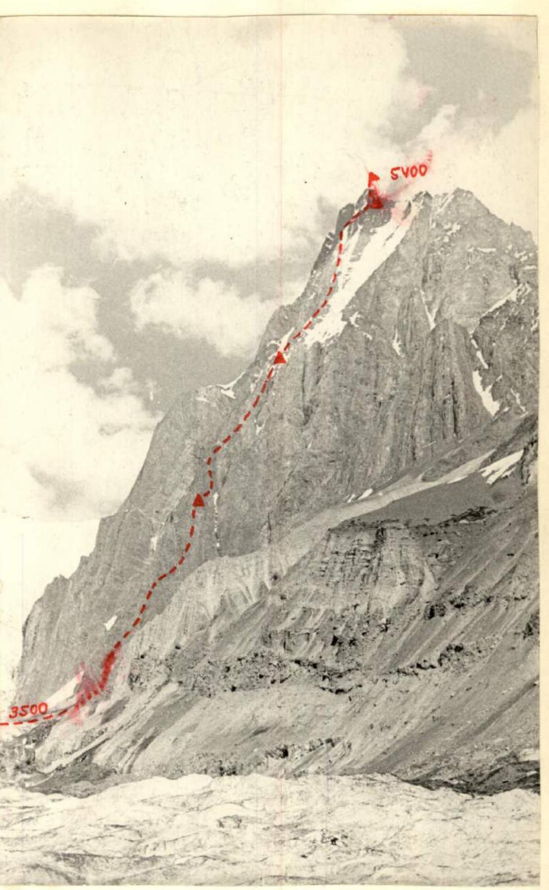
The choice of the route did not take much time, as the entire left part of the wall was immediately rejected due to the frequent fall of stones. On the other hand, to the right, along the counter-ridge of the northern wall, and then along its edge, a very logical, beautiful, and relatively safe route was visible. It started from the glacier (3500 m) and led directly to the summit point of the peak (5400 m), i.e., almost two kilometers of steep rocks with a small number of ice sections.
Route features:
- To the left of the route, there is a sheer, stone-dangerous northern wall.
- To the right, it is bounded by a steep ice slope, pierced by pieces of ice and stones.
- The middle part of the counter-ridge, before the exit to the edge, looked problematic from below.
- Due to the large distance (about 2 km vertically), the passage of the summit section was not entirely clear.
In the remaining time, the Piskulov — Bechkurov duo began processing the exit under the avalanche cone, from which the route began. Here, the glacier is so torn that we had to apply the highest ice climbing technique, climbing almost sheer ice walls. Having marked the processed path, the duo returned to the tent, where they met the Ginzburg — Karaguba group returning from the ice fall reconnaissance. They reported that the passage through the center of the ice fall and along the left (orographic) part was impossible due to frequent ice avalanches. Only the right part remained, along which it was decided to descend.
On July 23, Piskulov — Bechkurov went to further processing, and Ginzburg — Karaguba, together with the other team members and coaches, went to reconnoiter the descent again. By evening, all preparations for the assault were completed:
- the ice couloir was processed,
- the exit to the rocks was prepared.
It turned out that, despite the large steepness, the route was quite destroyed.
It was decided that the final descent path would be decided by the ascent participants at the summit, since the eastern ridge of Bastilia blocked the lower part of the descent to the upper plateau of the Medvezhiy Glacier. From this plateau, it was decided to descend along the right part of the ice fall, exiting in the middle part to a rocky slope.
The group planned to complete the route with 3-4 bivouacs.
Description of the ascent to p. Bastilia via the western counterfort and the edge of the northern wall
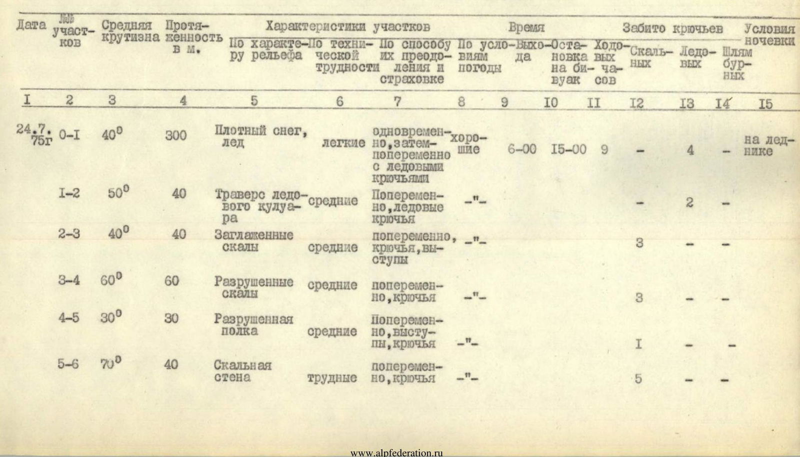
Section R0–R1
The route begins from the upper reaches of the heavily torn glacier tongue of the Medvezhiy Glacier. Ascent along a snow-ice avalanche cone to the gorge between p. Bastilia and the massif formed, according to the map, by p. 5422. Movement on crampons with the use of ice piton insurance. Due to the danger of ice avalanches, this section is recommended to be passed in the morning hours.
Section I–2
In the narrow part of the gorge — traverse left (40 m) through an avalanche slab to the exit to the rock counterfort.
Section 2–3
Exit to the rocks and further up along the right part of the counterfort. The rocks here are monolithic, cleared of crumbling rocks by ice avalanches.
Section 3–4
Movement straight up along the destroyed rocks of the counterfort. Climbing of medium difficulty (60 m). With each step, there are more and more "live" stones. The steepness gradually increases. Insurance with pitons.
Section 4–5
Traverse right-up along a poorly defined, destroyed shelf (30 m).
Section 5–6
40 m — ascent up steep, difficult rocks. Very few cracks for reliable piton insurance, which greatly complicates movement. Hauling of backpacks.
Section R6–R7
Overcoming 6 m of a belt of heavily destroyed rocks requires maximum caution.
Section R7–R8
15 m — steep rock slab. Climbing of medium difficulty. Section R8–R9. Easy climbing along a gentle (30°) section of the counterfort, 60 m long, leading to a wide shelf with a snow patch. Due to the abundance of "live" stones, movement requires certain caution.
Section R9–R10
From the shelf, going right-up onto heavily destroyed rocks (piton insurance!), ascent to the sharp ridge of the counterfort (5 ropes).
Section 10–II
Along the ridge of the counterfort, ascent up to the beginning of a narrow and steep snow-ice couloir with a stream ("first shoulder"). Here is a place for a bivouac. From the base camp on the Medvezhiy Glacier to the "first shoulder" — 9 hours. Average steepness is about 55°.
Section II–12.
Crossing the couloir in its lower part — ascent to the left (along the route) counterfort, forming the wall of the couloir.
Section 12–13
Ascent along a 60 m wall to a ridge with careful piton insurance, especially in the central, overhanging part of the wall, which is bypassed on the left along the route.
Section R3–R4
Along the sharp counterfort, composed of tile-like slabs, up 3 ropes to a slab of heavily "disintegrated" rocks. Further ascent along the slab, where it is very difficult to find a place for reliable intermediate insurance.
Section R4–R5
Bypassing the vertical ascent of the counterfort on the right, exit up along the wall to a steep inner corner, composed of narrow, vertically standing blocks. Ascent along the corner with careful, strong insurance, exiting onto dome-shaped rocks resembling a turtle shell. Hauling of backpacks.
Section I5–I6
Traverse right along a crack — exit under an overhanging inner corner, 40 m high, composed of monolithic yellow slabs.
Section I6–I7
Ascent straight up 10 m along the inner corner. Hauling of backpacks.
Section I7–I8
Traverse left-up along an inclined shelf and along it to a 3-meter monolithic sheer wall.
Section R18–R19
Along the 3-meter wall, exit vertically up into a 20-meter steep chimney, movement in which requires great caution due to destroyed rocks.
Section R19–R20
The chimney leads to a destroyed ridge, along which — 4 ropes to an ascent, where the entire group can gather.
Section R20–R21
The ascent is a 60 m section of wet rocks with snow. It leads to the "second shoulder" of the counterfort. From the first to the second shoulder — 8 hours of work, average steepness 60°. On the shoulder — a snow cornice, clearing the base of which on the rocks, you can make a place for a bivouac.
Section R21–R22
From here, the path goes up (60 m) along a steep snow-ice ridge to rocks protruding on the left along the route, along ice and snow. Insurance through an ice axe and then through an ice piton — exit to icy rocks.
Section R22–R23
Gentle ascent along rocks with a transition to a wide snow-ice couloir with a snow slab, resembling a white tie in the middle part of the route. To the right remain ice falls above a narrow rocky ridge, dividing the upper part of the passed long couloir with snow.
Section 23–24
Ascent along the boundary of rocks and snow onto a steep tile-like ridge of rocks, forming the edge of the wall.
Section 24–25
The steepness gradually increases, the ridge narrows, and turns into a sharp, sheer ridge in both directions (steepness of the ridge 70°), ending on the left with a wall, and on the right — with steep rocks on a couloir with ice and snow. Movement is along the edge, clearing the path from protruding narrow and sharp crumbling slabs, 150 m with careful piton insurance to the upper corner of the wall, which turns into steep rocks of the summit tower.
Section R25–R26
Ascent 25 m along the boundary of rocks and a steep ice groove. Rock pitons are used for insurance.
Section R26–R27
Ascent left-up 10 m along a rocky inner corner. In the lower part of the inner corner:
- dirty, wet ice,
- covered with sand.
Difficult climbing, hauling of backpacks.
Section 27–28
Very difficult section (3 m) through a plug in the inner corner (passed with the use of ladders) and a 10 m section of steep, smooth rocks lead to an inclined shelf, shaped like a shell. On the shelf, the entire group can gather, however, the shelf is not suitable for a bivouac due to its steepness and danger of stone fall. From the "second shoulder" to the "shell-shaped shelf", the average steepness is 60°.
Section 28–29
The first tandem of the summit tower is bypassed on the right along a steep shelf with an exit to a narrow ice groove.
Section 29–30
Crossing the ice groove to the right. Cutting steps, ice pitons.
Section 30–31
Ascent onto a 20 m rocky wall of steel color, the lower part of which has smoothed cracks, and the upper, vertical part, consists of exfoliating thin slabs. Hauling of backpacks.
Section 31–32
The wall leads to a ledge ridge, which divides the ice groove into two branches. Further — descent into the right (along the route) narrow branch of the ice groove and crossing it to a gray rocky wall.
Section 32–33
40 m of difficult climbing up the gray wall onto a small shelf. Hauling of backpacks.
Section 33–34
Traverse right-up to an overhanging inner corner and along it left-up — onto a narrow shelf leading to a yellow inclined slab.
Section 34–35
From the slab, left-up along a destroyed inner corner (very stone-dangerous section) — exit under a sheer wall, composed of exfoliating thin slabs.
Section 35–36
Along a very difficult 10-meter wall — exit to a sharp ridge leading to the summit. Climbing along the wall is complicated by protruding "live" blocks, covered with snow. Movement requires maximum caution.
On the ridge, there is a platform formed by a snow drift on the rocks — a place for a bivouac.
- The tent is placed on the platform 2/3 full.
- From the bivouac on the "second shoulder" to the platform — 12 hours of work.
Section 36–37
From the platform, ascent up along the sharp ridge to a pass (40 m).
Section 37–38
3 m wall of very difficult climbing. Passed with the use of ladders.
Section 38–39
Along steep, icy, and snow-covered rocks, exit to the summit snow dome.
Section 39–40
Along a gentle snow ascent, exit to the summit. From the "shell-shaped shelf", the average steepness of the summit section is 70°.
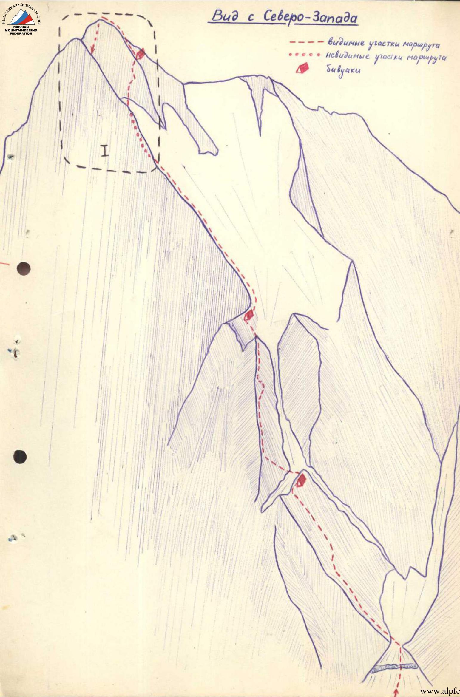
Descent from the summit to the southeast onto the upper plateau of the Medvezhiy Glacier. Further — bypassing p. Bastilia to the ice fall of the Medvezhiy Glacier. The ice fall is overcome along its right edge, near the boundary with rocks. Then — a long traverse to the right along rocky shelves to a couloir of the same name, along which — descent to the tongue of the glacier.
Conclusion on the route
The route to Peak Bastilia via the western counterfort and the edge of the northern wall is logical. The most difficult part of the route is located at altitudes above 5 thousand meters. The route is not industrial and can be passed by free climbing with full safety assurance. At the same time, the destroyed nature of individual sections of the route requires maximum caution from the ascent participants.
Considering their experience of ascending peaks of 5B category of difficulty (Dvoynashka, Delar, Khan-Tengri, Peak Engelsa, Uilpata, Peak Mushketova, Peak Moskovsky Pravdy, etc.), the team members believe that the route should undoubtedly be classified as 5B category of difficulty.
Extract from the minutes of the ascent review
Team captain Piskulov: "There are no comments on the ascent and the team members. The ascent proceeded clearly according to schedule, in a good sports spirit. The route along the northwest ridge undoubtedly belongs to the 5B category of difficulty and is one of the most interesting in the region."
Head of the training department of the Vysotnik camp, Kheisin D. B.: "The key to the success of the ascent is proper preparation and skillful conduct of it. The team's actions are correct and грамотны. The ascent and leadership should be credited."
Head of the KSP region, Ovcharov G. A.: "We are very glad that the sporting development of the Medvezhiy Glacier region has begun with such a strong ascent to p. Bastilia. A group of KSP instructors tried to make an ascent along the northwest ridge in the summer of 1974, but were stopped by prolonged bad weather. The route undoubtedly belongs to the 5B category of difficulty."
The protocol was led by
 (P.
Chochia)
(P.
Chochia)
Table of main characteristics of the ascent to p. Bastilia via the western counterfort and the edge of the northern wall
| 1 | 2 | 3 | 4 | 5 | 6 | 7 | 8 | 9 | 10 | 11 | 12 | 13 | 14 | 15 |
|---|---|---|---|---|---|---|---|---|---|---|---|---|---|---|

| 1 : 2 : 3 : 4 | : 5 | : 6 | : 7 | : 8 | : 9 | : 10 | : 11 | : 12 | : 13 | : 14 | : 15 |
|---|---|---|---|---|---|---|---|---|---|---|---|
| 15–16 50° | 40 | Traverse right along a crack | difficult | alternately, pitons | good | 3 | - | - | |||
| 16–17 80° | 10 | Steep inner corner, more difficult | alternately | 3 | - | - | |||||
| 17–18 60° | 15 | Inclined shelf | difficult | alternately, pitons | -"- | 3 | - | - | |||
| 18–19 70° | 23 | Wall and chimney | Very difficult | alternately, — | 5 | - | - | ||||
| 19–20 40° | 150 | Destroyed ridge | medium | simultaneously, alternately, insurance through ledges | -"- | - | - | - | |||
| 20–21 60° | 60 | Wet rocks with snow | medium | alternately, pitons | -"- | 3 | - | - | |||
| 26 July 2022 г. 50° | 80 | Snow-ice ridge | difficult | alternately, insurance through an ice axe and an ice piton | — 9:00 21:00 | 12 | - | I | - | bivouac area on the basis of a snow cornice | |
| 22-23 50° | 100 | Icy rocks, ice couloir | difficult | alternately, pitons, cutting steps | -"- | 5 | - | - | |||

I. Bud c
3onada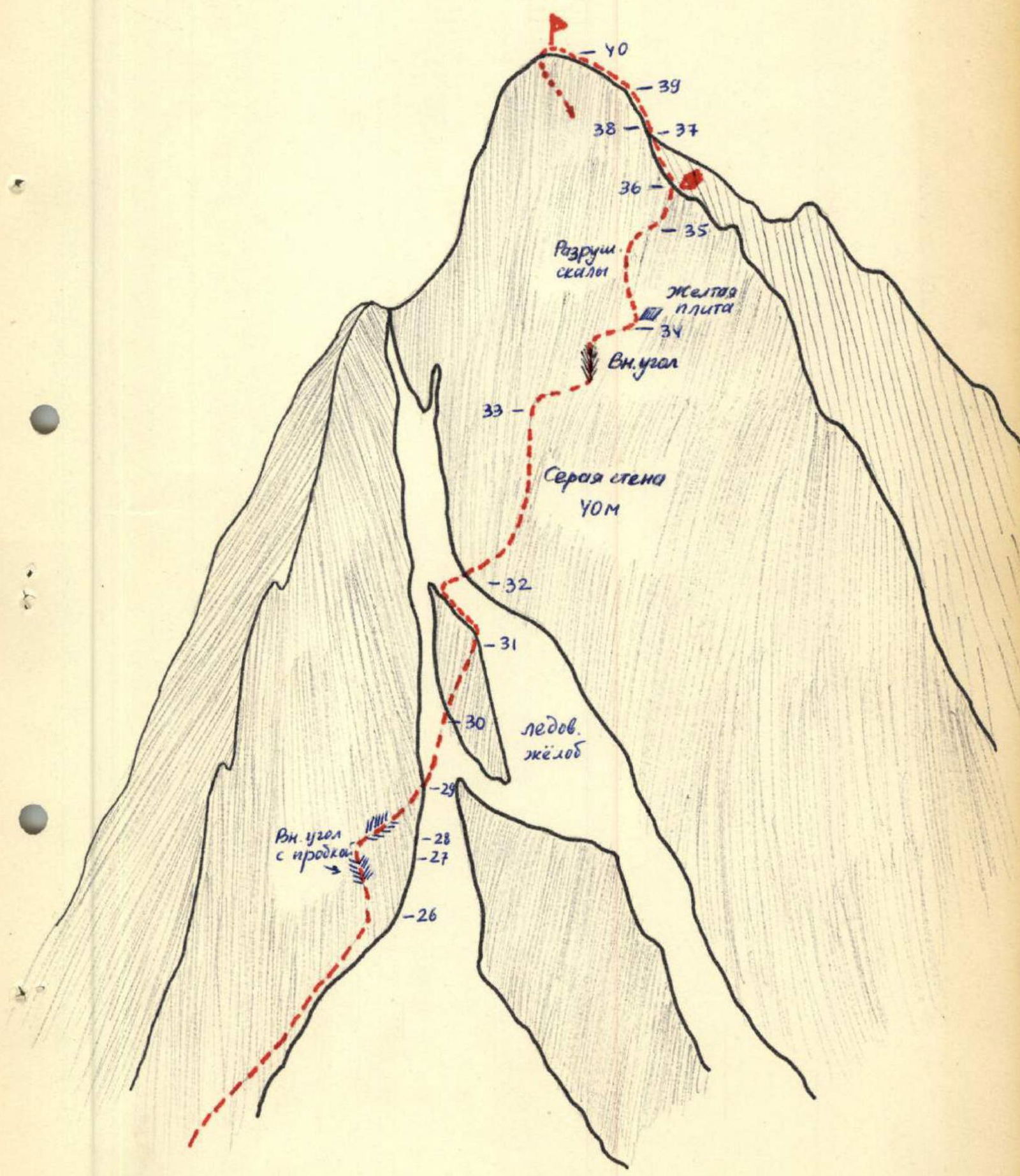
Profile
of the route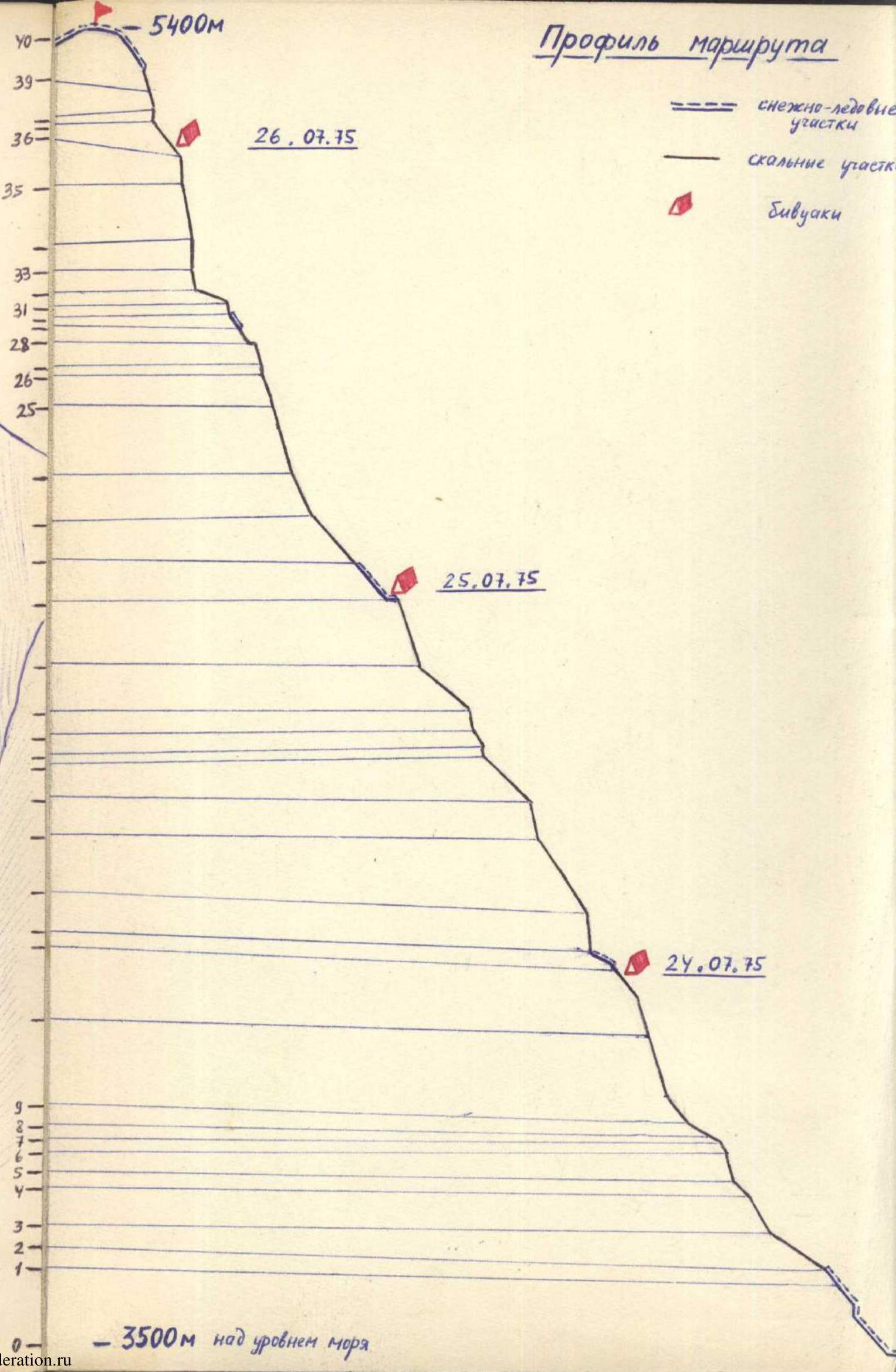
Peak Bastilia (Bud c 3onada)


