
Kamchatka
Sredinny Range Ichinsky volcano SE slope 3A cat. sl. g. Petropavlovsk (K)
1971

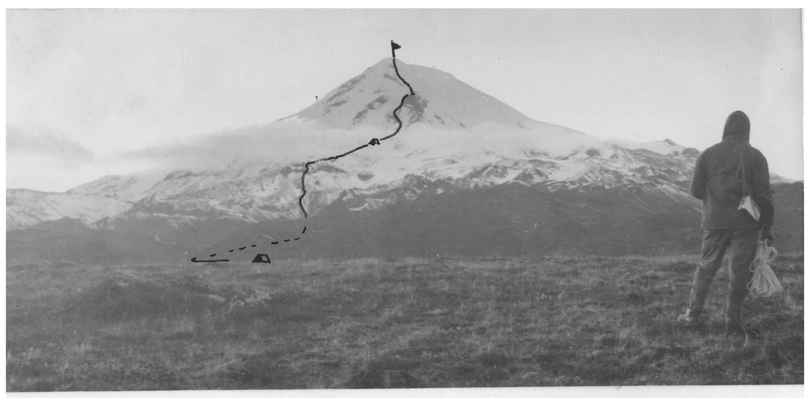
Sketch of the area of the Unnamed Peak.
Description of the ascent to the Ichinskaya summit from the SE 3A cat. sl.
1. Description of the volcano location
The Ichinsky volcano is located in the center of the Kamchatka Peninsula in the chain of the Sredinny Range. The Sredinny Range stretches from north to south for 1000 km and divides the peninsula into two almost equal parts: Eastern Kamchatka and Western Kamchatka. Among the volcanoes of the Sredinny Range, Ichinsky is the highest. Its height is 3621 m. The volcano is active.
The history of the volcano's activity is characterized by great complexity:
- Initial eruptions are represented mainly by basalts.
- Then a huge explosion occurred, which destroyed the summit part of the volcano.
- Initial basalt eruptions were replaced by andesite-dacite ones.
- Modern activity of the volcano is expressed in the presence of small fumarole activity on the northern slopes of the volcano.
The volcano has very large glaciation. Glacier tongues descend:
- to the south — to 1800 m;
- to the north — to 1400 m.
The summit is a powerful dome-shaped glacier, steeply descending to all parts of the world. 100–150 m below the highest point, the glacier is occasionally cut through by chains of rocks-"baranks" (frozen lava). Between the "baranks," the glacier is heavily crevassed with transverse cracks.
The snow line on the southern slopes is held in the summer at an altitude of 2200–2400 m. Long-term snowfields in the couloirs are located at an altitude of 1300–1400 m.
The weather, compared to other mountainous regions of Kamchatka, is stable here, but there is a lot of precipitation — up to 1000 mm per year.
The ascent is best done in the period from July 20 to September 15.
- Approach to the starting point of the ascent a/ Flight by plane. g. Petropavlovsk-Kamchatsky is connected to the settlement of Esso by regular air service. Other methods of transportation are more reliable but very time-consuming.
b/ Hiking. Move along the trail according to the attached scheme. There are plenty of firewood and water throughout the route, and you can stop for the night anywhere. In August-September, there are many berries and mushrooms. There is game: grouse, ducks. In numerous rivers, there are char.
The transition takes a full 3 days and ends at the pass 970 m, at the SE slopes of Ichinsky volcano. The camp should be set up at the mouth of the canyon, through which the stream from the volcano flows.
- There is firewood — dwarf cedar.
- You can go further along the canyon, about an hour's walk.
- There is still firewood there.
But from the canyon, the ascent route is not visible.
3. Description of the route by sections.
1st section. Height difference 1000 m. Steepness when moving along the canyon is significant. Along the slope of the volcano 20–30°. Move from the base camp along the canyon to the waterfall. To the left of the waterfall, along small and large scree — exit to a steep rocky slope. Rocks are simple (chaotic accumulation of fractures of frozen lava, 150 m).
Exit to the lava plateau. Duration of movement 5 hours. 2nd section. Height difference 900 m. Steepness 20°, at the final section 30–35°. Through the lava field to an unclearly expressed ridge, covered with slag and small scree. Direction of movement — gendarme (see photo 1 and 2). At an altitude of 2700 m, a steep ascent 30–35°.
To the left and right of the ridge are icefalls. At an altitude of 2800 m, the ridge flattens out into a small glacial plateau, covered with slag and small scree.
Night's stay. Water: ice and long-term snowfields. Duration of movement 6 hours. 3rd section
Height difference 400 m
Steepness 35–40°
Direction of movement — gendarme.
Along small scree, bypassing the gendarme:
- to the left
- or to the right when moving up.
Naled ice. Rocks of medium difficulty on a small section. Insurance is alternating.
Exit to the snow-ice slope. Duration of movement 3 hours. 4th section. Height difference 351 m. Steepness 35–40°. The slope is icy, местами covered with firn. To the left of the movement — rocky outcrops of the cirque wall, to the right — icefalls. Movement with alternating insurance 50–60 m before the summit — ice with a steepness of up to 50°.
The entire summit is a covering glacier. The cairn is located on the last rocks. From the summit, another summit of Ichinsky volcano, the Northern one, is visible. It is slightly lower than the Southern summit, which the route leads to.
The distance between the summits is 400–500 m.
The summits are connected to each other by an icy saddle.
Height difference between the Southern summit and the saddle: 150–200 m.
Duration of movement on the section: 2.5 hours.
4. Descent from the summit
Descent strictly along the ascent route. It is dangerous to go down to the icefall.
Do not descend through the couloirs — they end in high waterfalls.
Descent to the base camp — 8–9 hours.
- TIME CALCULATION FOR THE ROUTE.
Day 1, 2, 3 — transition from the settlement of Esso to the route.
Day 4
- 1st section — 5 hours.
- 2nd section — 6 hours.
Day 5
- 3rd section — 3 hours.
- 4th section — 2.5 hours.
- Descent to the base camp — 9 hours.
Total: 25.5 hours.
- Special equipment for a group of 6 people: a) main rope 2–3 × 40 m; b) rock pitons 2 pcs; c) ice pitons 4 pcs; d) carabiners 4 pcs; e) expendable rope 8 m; f) crampons 6 pairs
The description was compiled by (S. Grinkevich) on November 24, 1971
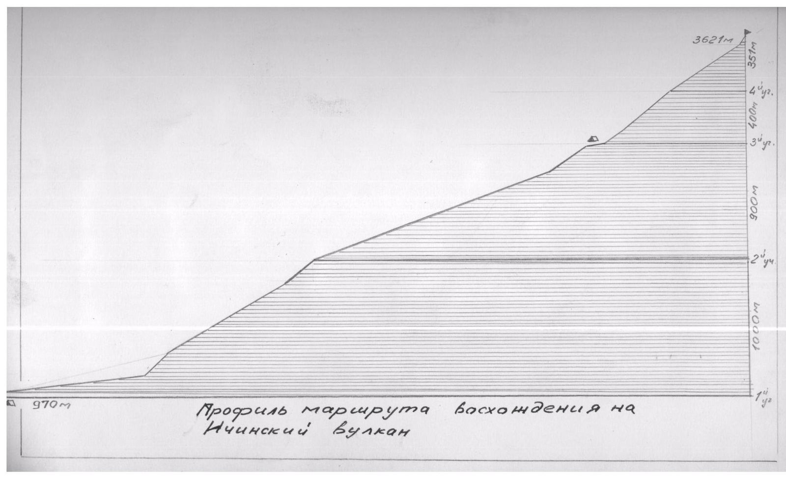
| 970 m | Profile of the route of the climber on Ichinsky Bulak |
|---|
Comments
Sign in to leave a comment