
Kamchatka Federation of Alpinism and Rock Climbing
REPORT
ON THE FIRST ASCENT TO THE 2-YA BASHNYA PEAK VIA THE "PO YUGO-ZAPADNOMU REBRO" ("NEVIDIMKA") ROUTE
CATEGORY 3B, MADE BY THE TEAM OF KAMCHATKA FEDERATION OF ALPINISM AND ROCK CLIMBING ON JULY 29, 2018
Ascent Details
| № | Category | Information |
|---|---|---|
| 1.1 | Leader's full name, sports rank | Zobenko A.A., 1st sports rank |
| 1.2 | Team members' full names, sports ranks | Lysenkov E.A., 1st sports rank, Dubrovin D., 2nd sports rank |
| 1.3 | Coach's full name | Kalyuzhny N.A., CMS |
| 1.4 | Organization | Kamchatka Federation of Alpinism and Rock Climbing |
| 2. Characteristics of the Ascent Object | ||
| 2.1 | Region | Ganal'skiye Vostryaki Ridge |
| 2.2 | Valley | - |
| 2.3 | Section number according to the 2013 Classification Table | 3.2 |
| 2.4 | Peak name and height | 2-ya Bashnya Peak, 2010 m |
| 2.5 | Geographical coordinates of the peak (latitude/longitude), GPS coordinates | N 53.48528° E 157.78873° |
| 3. Characteristics of the Route | ||
| 3.1 | Route name | "Po yugo-zapadnomu rebu 'Nevidimka'" |
| 3.2 | Proposed category of difficulty | 3B |
| 3.3 | Degree of route exploration | First ascent |
| 3.4 | Relief characteristics of the route | Combined |
| 3.5 | Height difference of the route | 700 m |
| 3.6 | Route length | 965 m |
| 3.7 | Technical elements of the route | I cat. sl. snow — 300 m |
| II cat. sl. snow/rocks — 234 m | ||
| III cat. sl. snow/rocks — 386 m | ||
| IV cat. sl. rocks — 37 m | ||
| V cat. sl. rocks — 8 m | ||
| 3.8 | Descent from the peak | See section 3 |
| 3.9 | Additional route characteristics | |
| 4. Characteristics of the Team's Actions | ||
| 4.1 | Time of movement (team's walking hours, indicated in hours and days) | 7 hours 52 minutes |
| 4.2 | Overnights | - |
| 4.3 | Start of the route | 06:43 |
| 4.4 | Reaching the peak | 14:35 |
| 4.5 | Return to the base camp | 17:00 |
| 5. Person Responsible for the Report | ||
| 5.1 | Full name, e-mail | Fedorov A.V., sanfed90@mail.ru |
1. Characteristics of the Ascent Object
Map of the ascent area
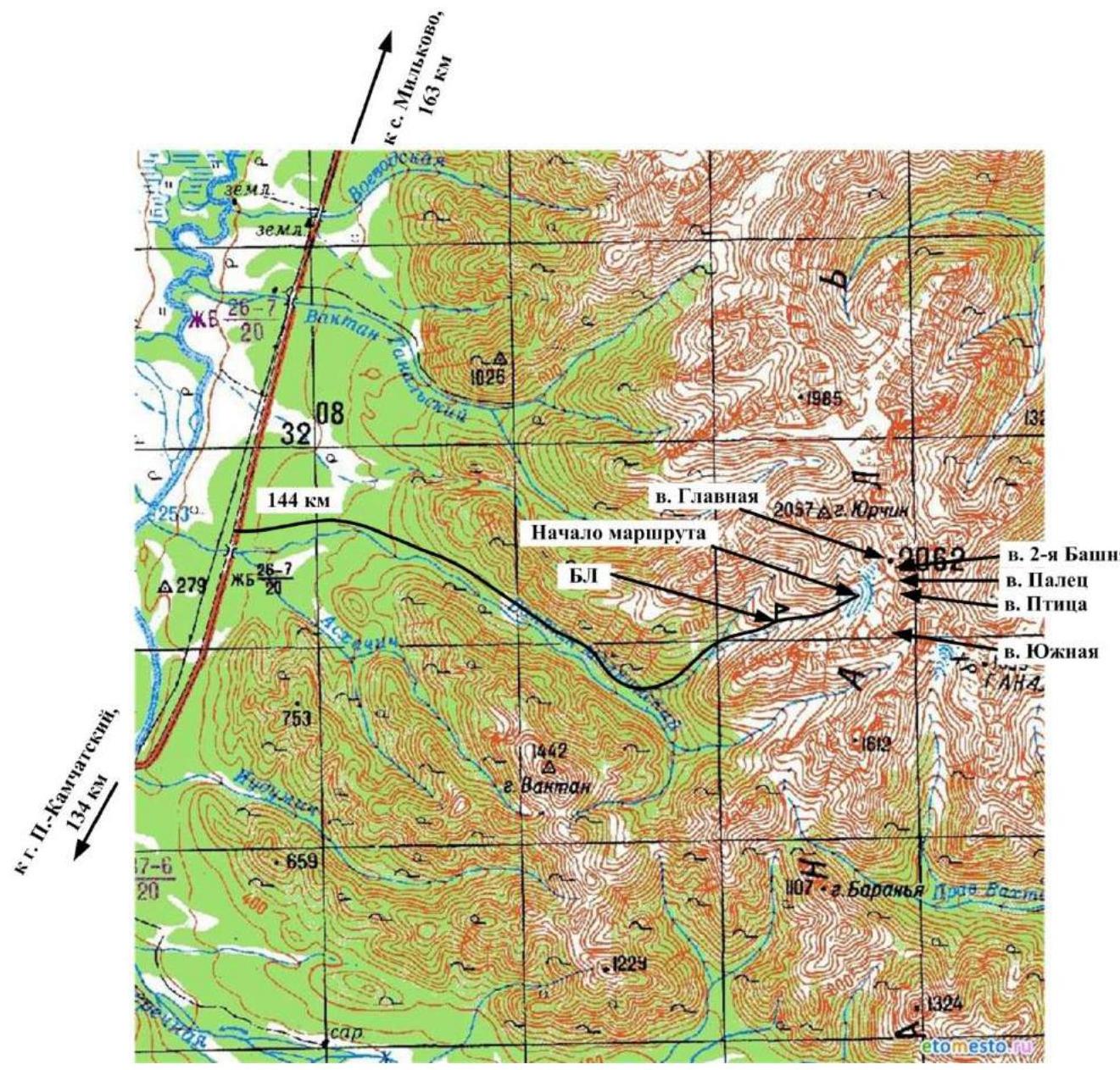
The Ganal'skiye Vostryaki Ridge is a compact area located in the southern part of the Kamchatka Peninsula, within the system of the Greater Eastern Ridge. Its length from northwest to southeast is 20 km, and its width is about 10 km. The maximum height is Glavnaya Peak, 2062 m.
The area is characterized by alpine mountain structure, with wall height differences reaching 450 m. Despite the relatively low absolute height, the cold season lasts nine months here. The first frosts occur in early September, and snow falls in the second half of September. In December-February, temperatures drop to -45 °C. Snow at the base camp level melts only by mid-June.
The most suitable period for ascents:
- Starting from mid-June.
Route to the mountain area:
- From Petropavlovsk-Kamchatsky, take any vehicle to the bridge over the Vaktan Malkinsky River, at the 144th km of the Milkovo highway.
- To the right of the bridge, a dirt forest road begins, approximately 9 km long. The first part is passable for almost any vehicle, while the second half is only accessible by high-clearance vehicles.
- At the end of the dirt road, a hiking trail starts to the left, into the gorge, along the first tributary of the V. Malkinsky River. Follow the trail up the left side of the valley, then it leads to a terrace. Cross the bed of a small stream at the boundary between the forest and the bushes. Continue along the left slope of the tributary flowing from Yurhik Peak, cross the tributary after 300 meters, and head towards the cirque. Move to a suitable clearing located on a bend of the stream, opposite a distinct pass on the right side of the cirque. The ascent along the trail is about 500 m, and the distance is approximately 4 km.
Approach to the route: from the base camp, up the gorge, along the stony moraine, 1.5 km to a large snowfield covering the foot of the cirque.
Panorama of the Ganal'skiye Ostrayki Ridge, Main Gorge. Shooting point № 1. Height 900 m. Camera: Canon Power Shot Pro 1 (Zoom). September 2005 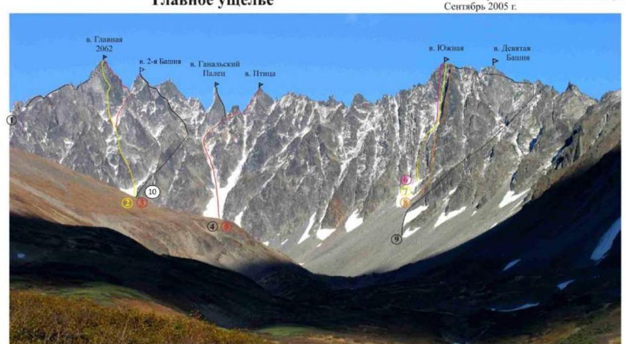
- "From the northwest", 3B cat. sl. led by I. Korbuh. 1981.
- "Through the center of the southwest wall", 5B cat. sl. F. Farberov, S. Panyukhin. 1991.
- "Along the South ridge", 4A cat. sl. I. Benedyk, O. Chirik, D. Ermolaev. 2006.
- "Along the South ridge", 5A cat. sl. F. Farberov, S. Panyukhin. 1991.
- "Along the North ridge", 3B cat. sl. I. Benedyk, O. Chirik, E. Lysenkov. 2005.
- "Through the center of the northwest wall", 5B cat. sl. F. Farberov, S. Panyukhin. 1991.
- "M-33" 5B cat. sl. I. Benedyk, O. Chirik, A. Bichenko. 2001.
- "Along the edge of the northwest wall", 5A cat. sl. A. Bichenko, A. Alekseev, I. Bekrin. 1995.
- "Along the South crest", 2B cat. sl. A. Bichenko, A. Kon'shin, R. Sagitova. 1998.
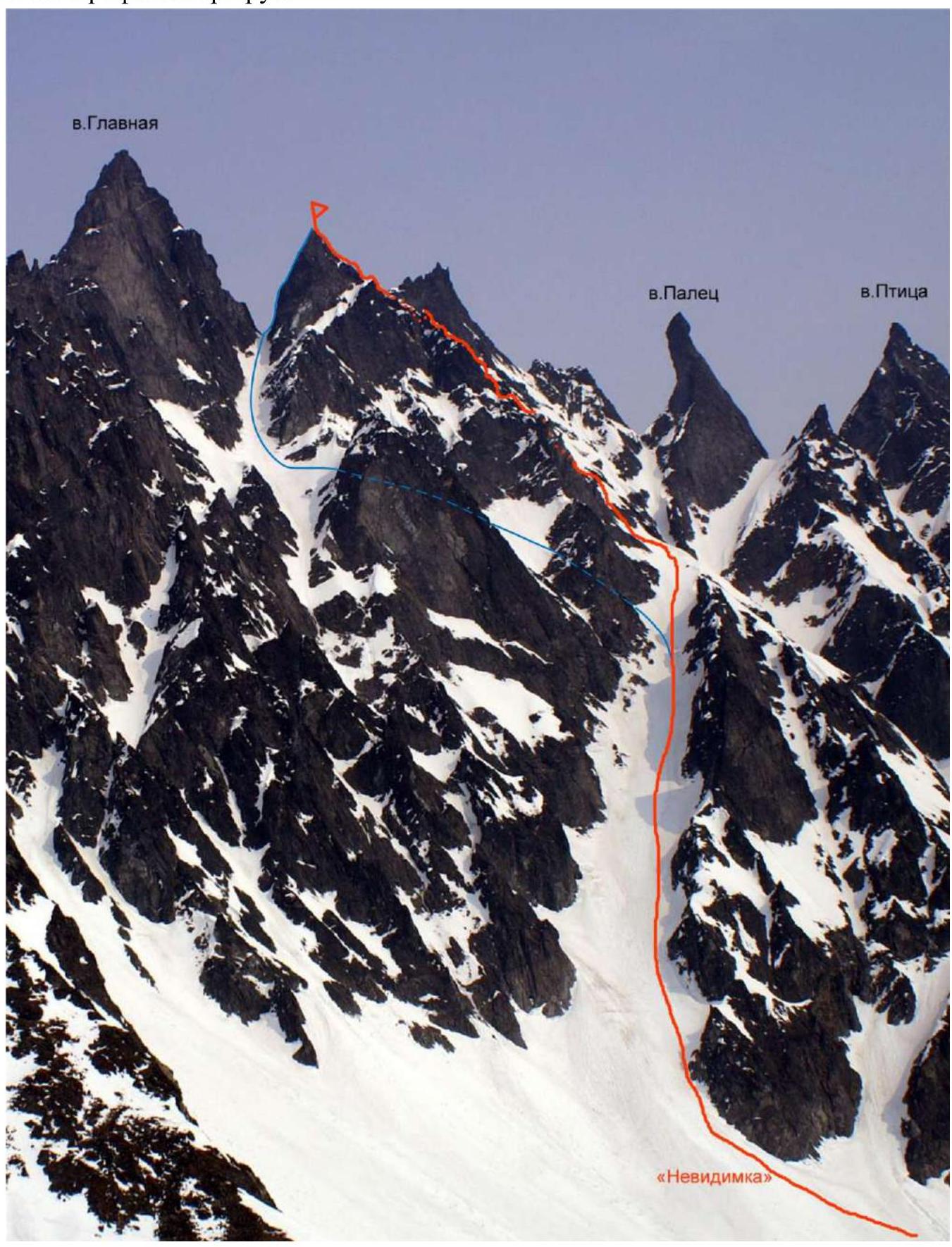
- Team's route, "Along the southwest ridge", 3B cat. sl. General photo of the 2-ya Bashnya peak with the route taken by the team
Date taken: June 2021. Shooting point: N 53.46945° E 157.76298°. Height of the shooting point: 1400 m.
2. Characteristics of the Route
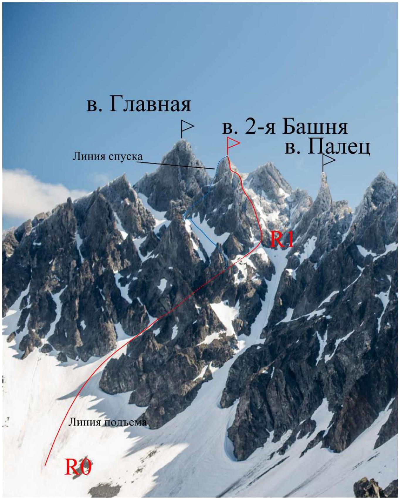
Photo of the route profile
Technical photo of the route (section R1-R8, R8-Peak)
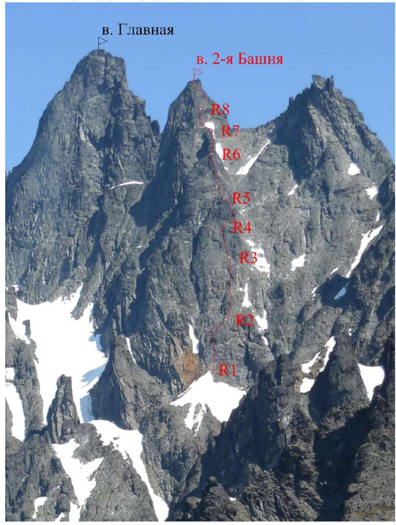
2.3. Technical Characteristics of the Route Sections
| Section № | Relief characteristics | Category of difficulty | Length, m | Type and number of hooks |
|---|---|---|---|---|
| R0-R1 | Snow | 1 | 300 m | - |
| Snow | 2-3 | 400 m | ||
| R1-R2 | Rocks | 3 | 15 m | Anchors, friends, 5 hooks |
| Rocks | 3+ | 10 m | ||
| Rocks | 3 | 15 m | ||
| R2-R3 | Rocks | 3 | 15 m | Anchors, friends, 4 pcs-4 |
| Rocks | 3+ | 10 m | ||
| Rocks | 2 | 5 m | ||
| R3-R4 | Rocks | 3 | 15 m | Anchors, friends, 5 hooks |
| Rocks | 3+ | 10 m | ||
| Rocks | 3 | 10 m | ||
| R4-R5 | Rocks/tr. terrace | 2 | 7 m | Anchors, friends, 4 hooks |
| Rocks | 4 | 8 m | ||
| Rocks | 3 | 15 m | ||
| R5-R6 | Rocks | 3 | 15 m | Anchors, friends, 4 hooks |
| Rocks | 5- | 8 m | ||
| Rocks | 3 | 15 m | ||
| R6-R7 | Rocks | 4+ | 7 m | Friends, 2 pcs., loops |
| Rocks | 3 | 18 m | ||
| R7-R8 | Rocks/tr. terrace | 2 | 7 m | Anchors, friends, 3 pcs. |
| Rocks | 3 | 8 m | ||
| Rocks | 4- | 7 m | ||
| Rocks/tr. terrace | 2 | 10 m | ||
| Section № | Relief characteristics | Cat. sl. | Length, m | Type and number of hooks |
| :--------: | :--------------------: | :--------------------: | :-------: | :----------------------: |
| R8-Peak | Rocks/tr. terrace | 2-3 | 10 m | Anchors, friends, 4 hooks |
| Rocks | 3 | 5 m | ||
| Rocks | 4+ | 15 m | ||
| Rocks | 3 | 5 m |
3. Characteristics of the Team's Actions
Brief description of the route passage.
Section R0-R1. The start of the route is from the relatively gentle center of the Ganal'skiye Vostryaki cirque. Then, move over snow/firn, in crampons, towards the entrance to the couloir, bypassing the Glavnaya Peak massif on the right, in the direction of the Paltse Peak. Length 300 m, slope up to 35°, category 1.
Further movement along the couloir in the direction of the ridge. Length 400 m, slope reaches 40°-50°, category 2-3, with ice and crevasses present. May require belaying.
Note: from the second half of summer, the couloir may start to thaw, exposing stony, loose deposits.
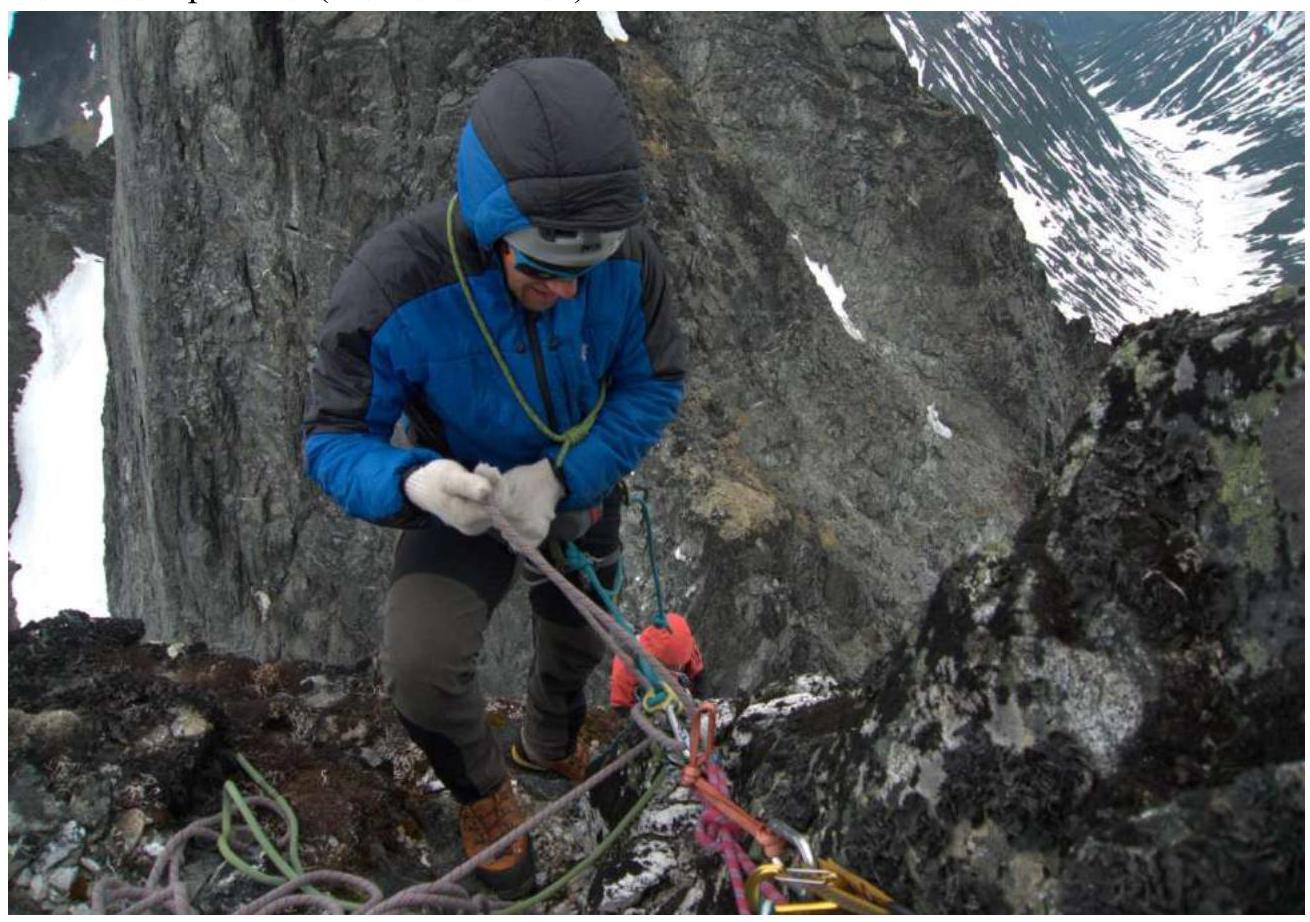
Section R1-R2. From the saddle, the technical rock part of the route begins. Station on a rock ledge. Move straight up with variable belaying along the moderately destroyed wall in the direction of a slightly overhanging rock forehead, 15 m, category 3, slope up to 60°. Then, bypass the forehead on the left along the internal angle, exiting to the right onto a vague counterfort, 10 m, category 3+, slope up to 70°. Further movement along the counterfort for 15 m, category 3, slope 50°-60°. Belaying on anchor elements (anchors, friends: small and medium sizes) and anchor hooks. Station on a rock ledge.
Section R2-R3. Move straight up with variable belaying along the continuing moderately destroyed counterfort, ending in a wall, 15 m, category 3, slope up to 60°. Then, move up along a system of internal angles, bypassing two cornices on the left, 15 m, category 3+, slope up to 70°. Further, exit onto a flattening slope, partly grassy with moss, possibly snow-covered in the first half of summer, 5 m, category 2, slope up to 40°. Belaying on anchor elements (anchors, friends: small and medium sizes). Station on a rock ledge.
Section R3-R4. Move straight up with variable belaying along a moderately destroyed wall, passing between an obvious cornice and an internal angle (on the left and right, respectively), 15 m, category 3, slope up to 60°; 10 m, category 3+, slope up to 70°. Then, move with a shift to the right onto an obvious ledge located under a rock forehead, 10 m, category 3, slope up to 60°. Movement is mainly along monolithic large slabs, with "live" stones and moss present (slippery!). Belaying on anchor elements (friends: small and medium sizes) and anchor hooks. Station on self-made points.
Section R4-R5. Move to the right along the ledge with variable belaying for 7 m, category 2, to an obvious internal angle. Then, move up along the internal angle until it flattens, the angle is formed by monolithic slabs with limited handholds, 8 m, category 4, slope up to 75°. Further, move along the ridge, bypassing small gendarmes on the right, 15 m, category 3, slope up to 60°. Belaying on anchor elements and anchor hooks (friends: small and medium sizes). Station under a gendarme on a rock ledge.
Section R5-R6. Move straight up with variable belaying along a wall consisting of numerous blocks of medium size, in the direction of an internal angle located to the left of an obvious gendarme, 15 m, category 3, slope up to 60°. Then, move up along the internal angle along large blocks, exiting slightly to the right onto the beginning of a rock ridge leading to the summit tower, 5 m, category 5-, slope up to 90°. Further, move along the ridge until its clear narrowing, 15 m, category 3, slope up to 60°. Belaying on anchor elements and anchor hooks (friends: small and medium sizes). Station on a rock ledge.
Route Features:
- Movement with variable belaying
- Belaying on anchor elements and anchor hooks (friends: small and medium sizes)
Station on a rock ledge.
Section R6-R7. In the first part of the section, move straight "into the forehead" onto a narrow, destroyed rock ridge "knife" (width 1.5-3 m) with variable belaying, 7 m, category 4+, slope 80°. Then, move along the "knife" with short sections of tense climbing, 8 m, category 3, slope up to 40°-50°. Further, move to the right and along gendarmes through a system of stone blocks and grassy ledges until exiting onto a grassy terrace (possibly snow-covered in the first half of summer) at the end of the "knife", 10 m, category 3, slope up to 70°. Belaying on anchor elements (friends: small and medium sizes) and rock outcrops. Station on hooks.
Section R7-R8. Move to the left along the terrace towards a wall under an obvious passage, consisting of a system of stone blocks forming steps, with an exit into a destroyed internal angle, and then onto a grassy (possibly snow-covered) terrace, 10 m, category 2, slope up to 40°; 8 m, category 3, slope up to 60°; 7 m, category 4-, slope up to 80°; 10 m, category 2, slope up to 50°. Belaying on anchor elements (anchors, friends: small and medium sizes). Station on a rock ledge.
Section R8-Peak. Move up with variable belaying through the next inclined terrace, covered with snow/grass (moss), bypassing a stretched, strongly smoothed rock "tongue" coming from the summit tower on the right (in the direction of movement), 10 m, category 2-3, slope 40°-60°.
Further:
- Up along a system of large rock monolithic blocks, exiting onto strongly smoothed monolithic slabs, 5 m, category 3, slope 60°;
- Move to the left (bypassing the summit tower) and up along the slabs to the peak, tense climbing, slabs are strongly smoothed with limited handholds, 15 m, category 4+, slope up to 70°; 5 m, category 3, slope 60°.
Belaying on anchor elements (friends: small and medium sizes), rock hooks. Station on the peak on self-made points (friends, hooks).
Descent.
- Two rappels of 35 m each (the first on a rock hook, the second on a loop) onto a snow saddle between Glavnaya Peak and 2-ya Bashnya Peak. Then, descend along the couloir for 150 m, turning left (in the direction of descent) to bypass the rock massif of 2-ya Bashnya Peak. Further, move along the snowfield, traversing along the rock massif, then pass between two large rocks, and exit into the ascent couloir, slightly below the start of the rock part of the route. Then, descend along the ascent route.
Conclusion. The ascent participants have experience in climbing routes up to category 5B, inclusive, in various mountain ranges of the Russian Federation and the CIS. Comparing the considered route with others, including those in the Ganal'skiye Vostryaki area (Glavnaya Peak, 3B "from the northwest", Ptitsa Peak, 3B "along the northern ridge", Glavnaya Peak, 4A "along the southern ridge"), the team concluded that the described route corresponds to the complexity category of 3B.
In general, the Ganal'skiye Vostryaki area is characterized by strong destruction of rock formations. However, this route is not significantly affected by destruction and can be recommended as a training route, which is extremely important for the development of alpinism in the Kamchatka region, as there is a clear deficit of categorized routes of 2-3 categories necessary for conducting training camps within the framework of NP-2, SP-1.
Photo of section
R3–R4 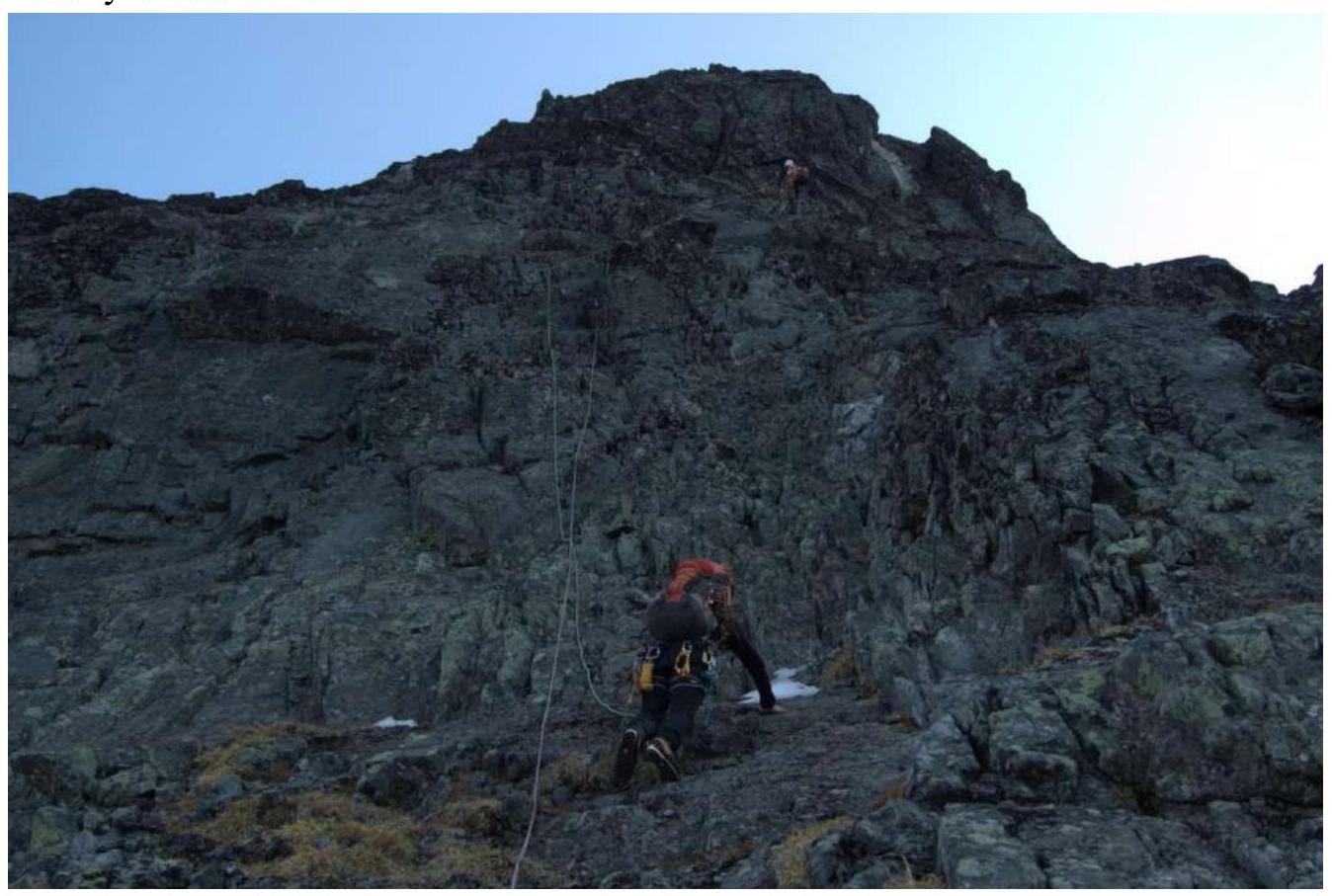
Photo of section
R4–R5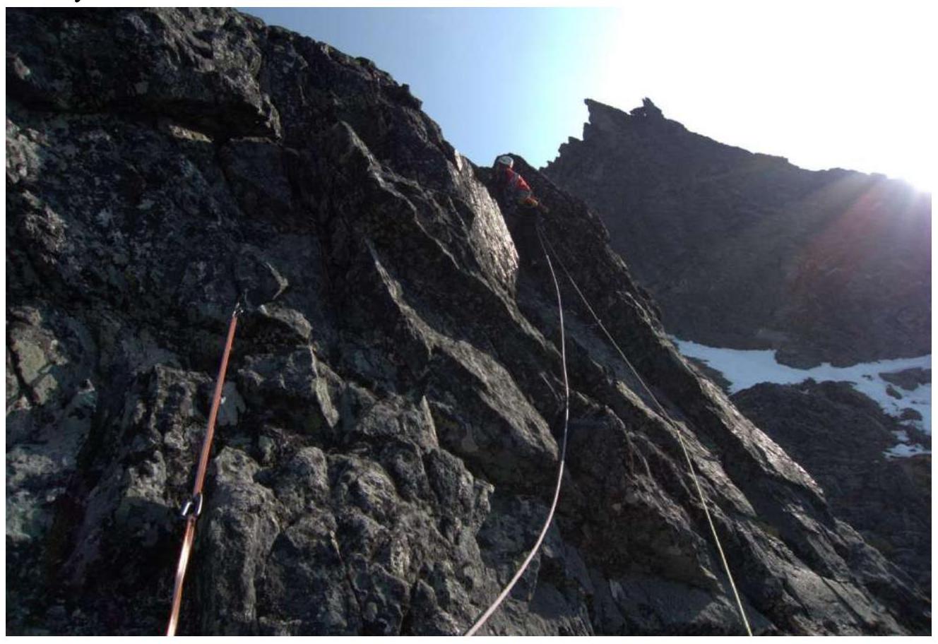
Photo of section
R5–R6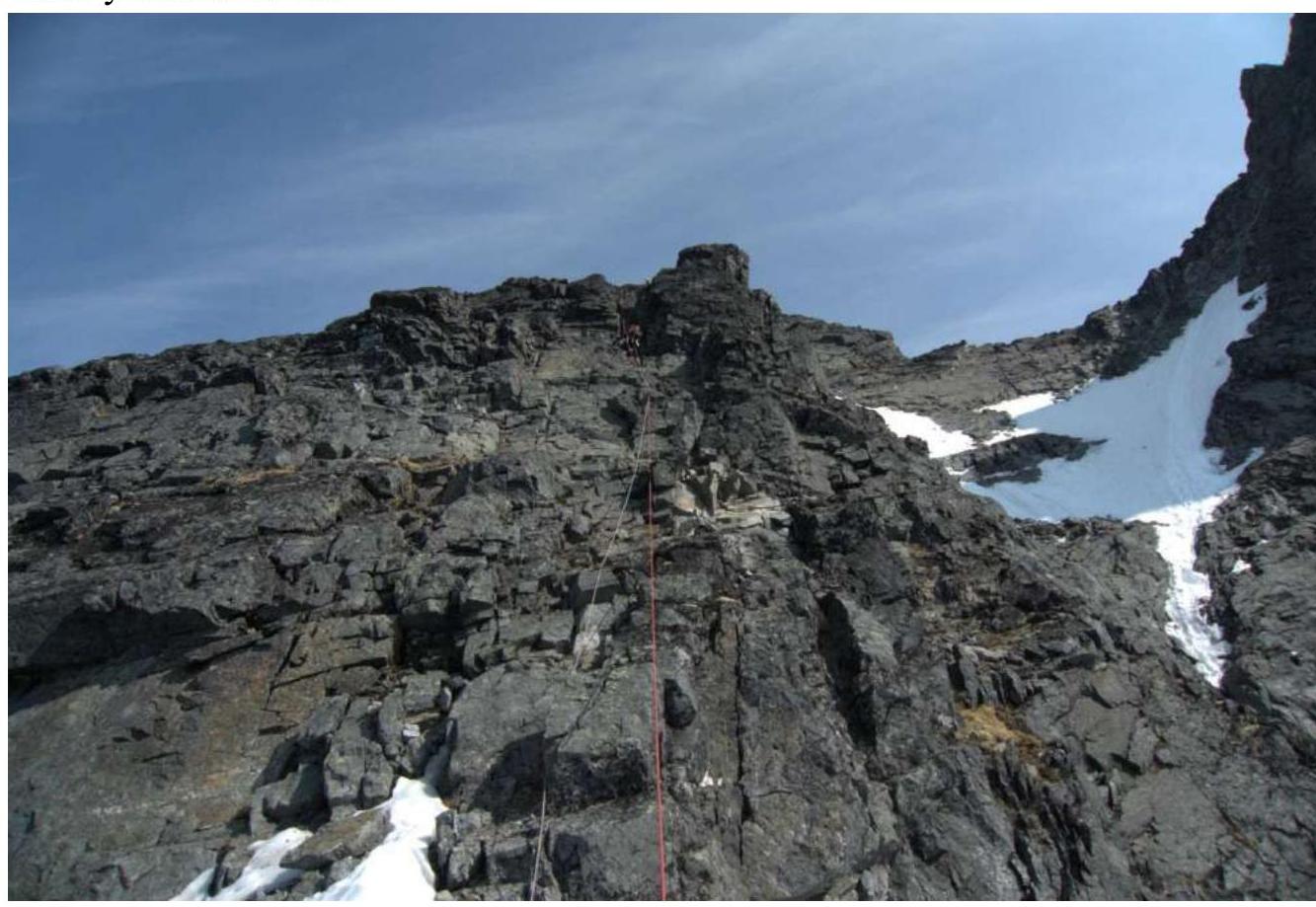
Photo of section R6–R7 (the passage through the wall between the snowfields of section R7-R8 is also visible)
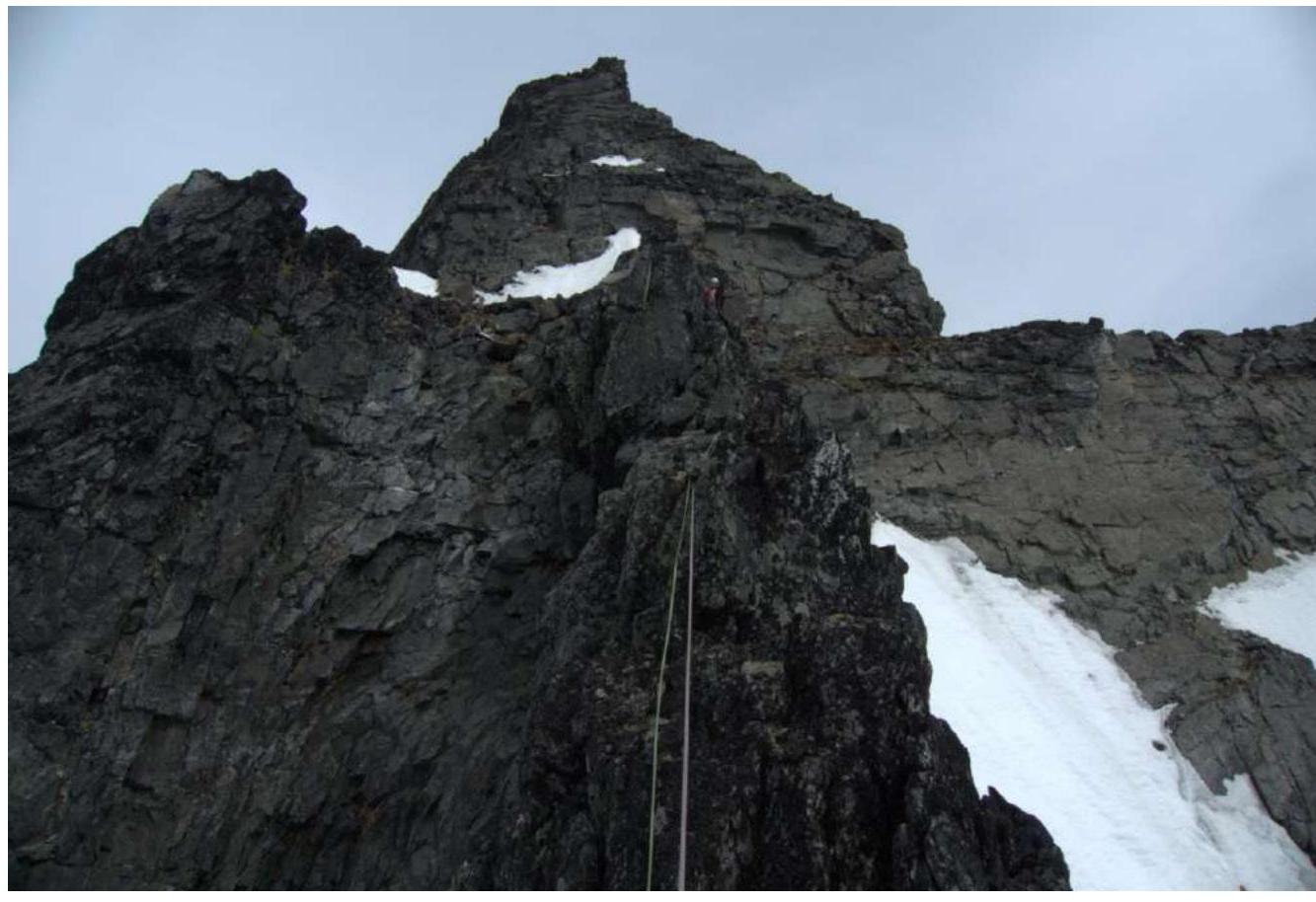
Photo of section
R8–Peak 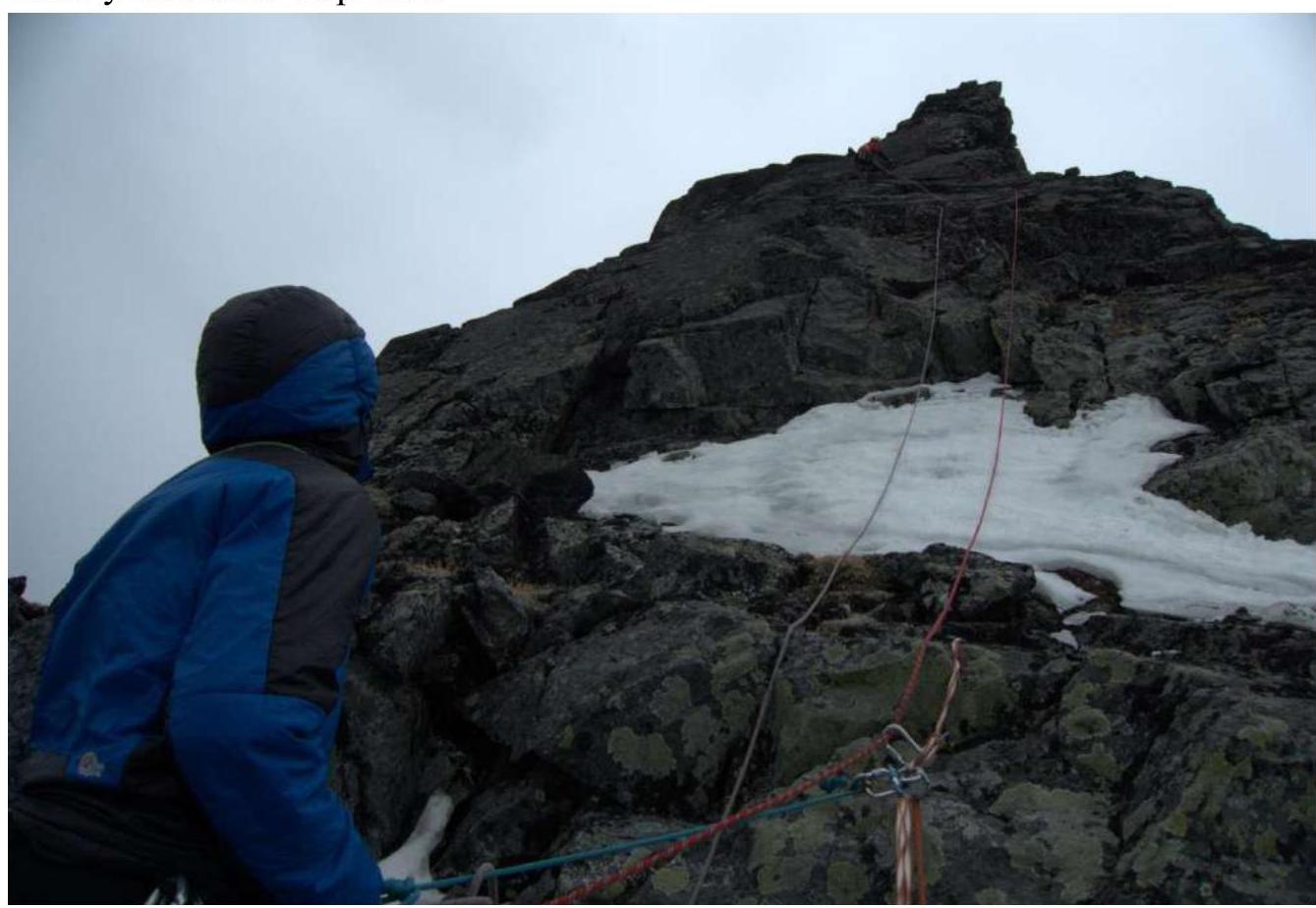
Photo on the peak (Zobenko A.A.)

Photo on the peak (Lysenkov E.A.)
Comments
Sign in to leave a comment