Passport
- Russia, Kamchatka Peninsula, Ganal Range Section No. 3 KMGV
- Main Peak (2062 m)
Route: "via the North-Eastern wall"
- Proposed – 4A category of difficulty. First ascent
- Route type: rock
- Height difference of the rock part of the route: 362 m.
Length of the rock part of the route: 461 m. Length of sections: V category of difficulty: 70 m. Average steepness of the route: 63°
- Left on the route: hook – 1 pc., friend – 1 pc.
- Team's walking hours: 11 h 40 min.
- Leader: Ivan Nikolayevich Benedyuk 1st sports category
Participants: Alexander Alexandrovich Ryzhkov II sports category, Pavel Vyacheslavovich Karpushin II sports category
- Coach: Nikolai Alexeyevich Kalyuzhny – Candidate Master of Sports
- Exit from Base Camp: 3:30 AM, June 18, 2010.
Exit to the route: 8:00 AM. Exit to the summit: 7:40 PM. Return to Base Camp: 1:00 AM, June 19, 2010.
- Kamchatka Federation of Mountaineering and Rock Climbing VNkarpenko@yandex.ru
- Responsible for the report: I.N. Benedyuk ivanbenedyk@yandex.ru, tel. 8-914-788-2032
General photo of the summit
(view from the north-east)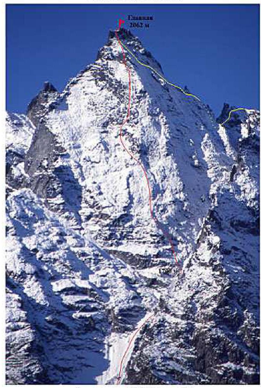
The photo was taken on August 12, 1998 (slide). Shooting point No. 4. Height 1000 m. Distance – 3000 m. Camera: Olympus Stylus (Zoom)
- "Via the north-eastern wall", I. Benedyuk 2010
- "From the north-west", 3B category of difficulty. I. Korbuh 1981
Photo of the route profile from the right (Main Peak, view from the north-west)
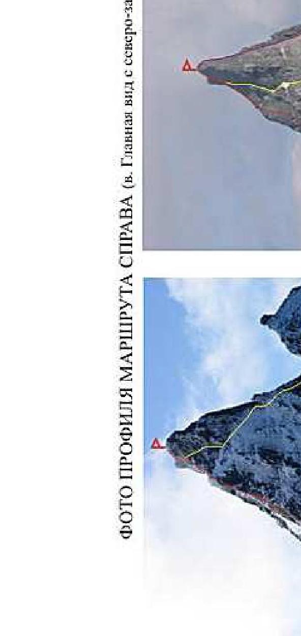
The photo was taken at the "Yurчик–Main" pass, September 16, 2009. Shooting point No. 1. Height 1800 m, distance – 600 m. Camera: Canon Power Shot Pro 1 (Zoom)
The photo was taken from the eastern ridge of Yurчик Peak, June 19, 2010. Shooting point No. 2. Height 1950 m, distance – 1300 m. Camera: Canon Power Shot Pro 1 (Zoom)
- "Via the north-eastern wall", I. Benedyuk 2010
- "From the north-west", 3B category of difficulty. I. Korbuh 1981
- "Via the center of the western wall", 5B category of difficulty. F. Farberov 1991
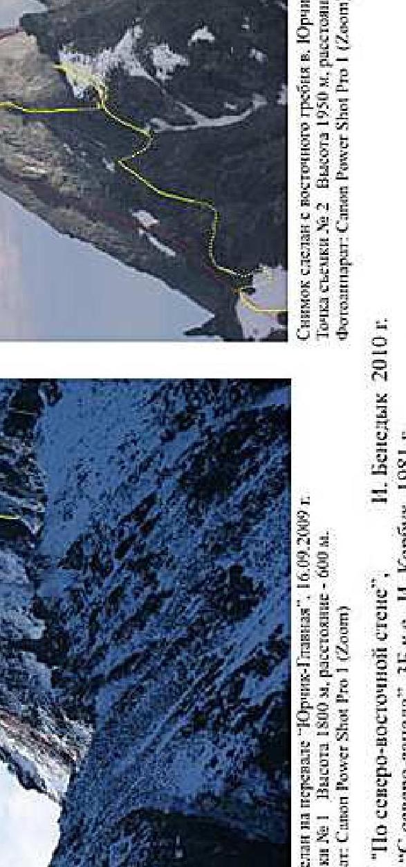
Photopanorama of the ascent area
Ptitsa Peak (2006 m):
- "Via the northern edge", 3B category of difficulty.
- I. Benedyuk, 2005
Ganal'skiy Palets Peak (2007 m):
- "Via the south-western edge", 5A category of difficulty.
- F. Farberov, 1991
Main Peak (2062 m):
- "Via the north-eastern wall",
- I. Benedyuk, 2010
- "From the north-west", 3B category of difficulty.
- I. Korbuh 1981
- "Via the center of the western wall", 5B category of difficulty.
- F. Farberov 1991
- "Via the southern edge", 4A category of difficulty.
- I. Benedyuk 2006
The photo was taken on August 12, 1998 (slide). Shooting point No. 4, height 900 m. Distance – 3000 m. Camera: Olympus Stylus (Zoom)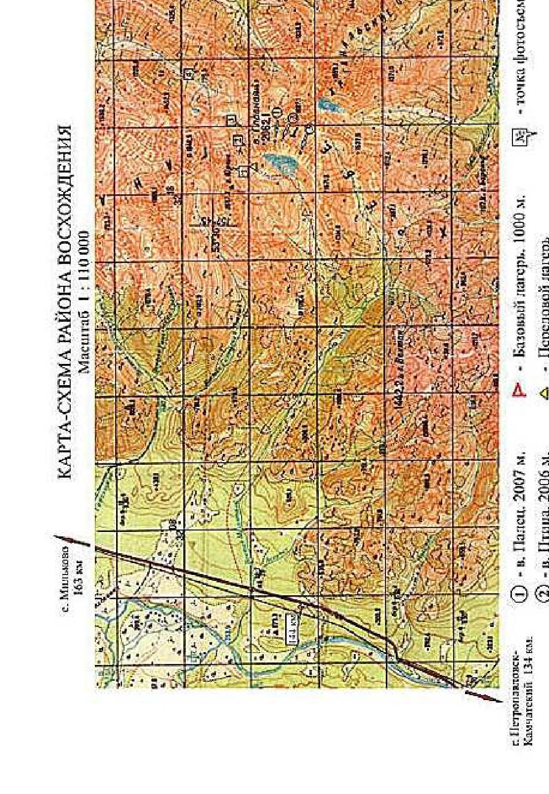
Map-scheme of the ascent area
Scale 1:110000
- Base Camp, 1000 m.
- Advanced Camp
- approach path
- Palets Peak (2007 m).
- Ptitsa Peak (2006 m).
- Yuzhnaya Peak (1950 m).
- No. – photo shooting point
Brief overview of the ascent area
In the southern part of the Kamchatka Peninsula, within the Big Eastern Ridge system, lies a unique, compact area – the Ganal'skiye Ostryaki Ridge. Its length from north-west to south-east is 20 km, and about 10 km from north-east to south-west. The maximum height is Main Peak at 2062 m.
The area is characterized by alpine mountain structure, with wall height differences reaching 450 m. Despite the relatively low absolute height of the objects, winter here lasts nine months. The first frosts begin in early September, and snow falls around September 15-20. In December-February, temperatures can drop to -45 °C. Snow at the Base Camp level melts only by mid-June.
Most ascents in the area are made during the summer. The most suitable period for summer expeditions is from mid-June to the first decade of September.
From the city of Petropavlovsk-Kamchatsky, it's convenient to drive to the bridge over the Vaktan Malkinsky River – 144th km of the Milkovo highway (see the map-scheme of the area). Beyond the bridge, turn right, and you can drive another 5-6 km along the forest road. Then, on foot or by high-clearance vehicle, continue another 5 km to the trail. The landmark is the gully to the left. This is the first tributary of the Upper Malkinsky River along the way. The further path goes up the gully – a hiking trail. Walk along the right side of the gully, up to the terrace. Then cross the bed of a small stream at the boundary of the forest and bushes. The ascent to the upper valley will take 50-60 minutes. From this point, a panorama of all the main peaks opens up. From here to Base Camp is 3 km. The trail then goes along the right slope of the tributary flowing from Yurчик Peak, after 400 m – cross the tributary and head towards the main cirque, to the cedar thickets on the moraine cushions. Here, near the left side of the gully, is a good place for camping – the main Base Camp for ascents via routes from the Main gully. Height – 1000 m. The landmark is a picturesque grassy pass above the camp in the mountain ridge.
Travel time from the city to the Vaktan Malkinsky River is 2.5 hours. The walking part of the journey – 10 km – takes 3.5-4 hours.
Approach to the route.
From Base Camp, go north-east up the gully, along the stony moraine, to a large snowfield completely covering the cirque floor. Walk along the snowfield to the end, and then ascend to the upper cirque of Yurчик Peak. Here, under the ascent to the pass, you can set up an Advanced Camp. Overnight stay, water available.
From Base Camp, it's 2.5 km, height – 1500 m, height difference from Base Camp – 500 m. This is also where the ascent to the start of the "From the north-west" route, 3B category, begins – a good option for a preliminary warm-up ascent.
On the day of the ascent.
Ascent from Advanced Camp to the pass point – the extreme right depression in the saddle. The path to the pass will take about 1 hour, pass height – 1800 m. Then descend along a steep snowy couloir into the North cirque, losing height to 1250 m, and then ascend to the start of the route.
The transition from Advanced Camp through the pass to the start of the rock part of the route takes 3.5-4 hours.
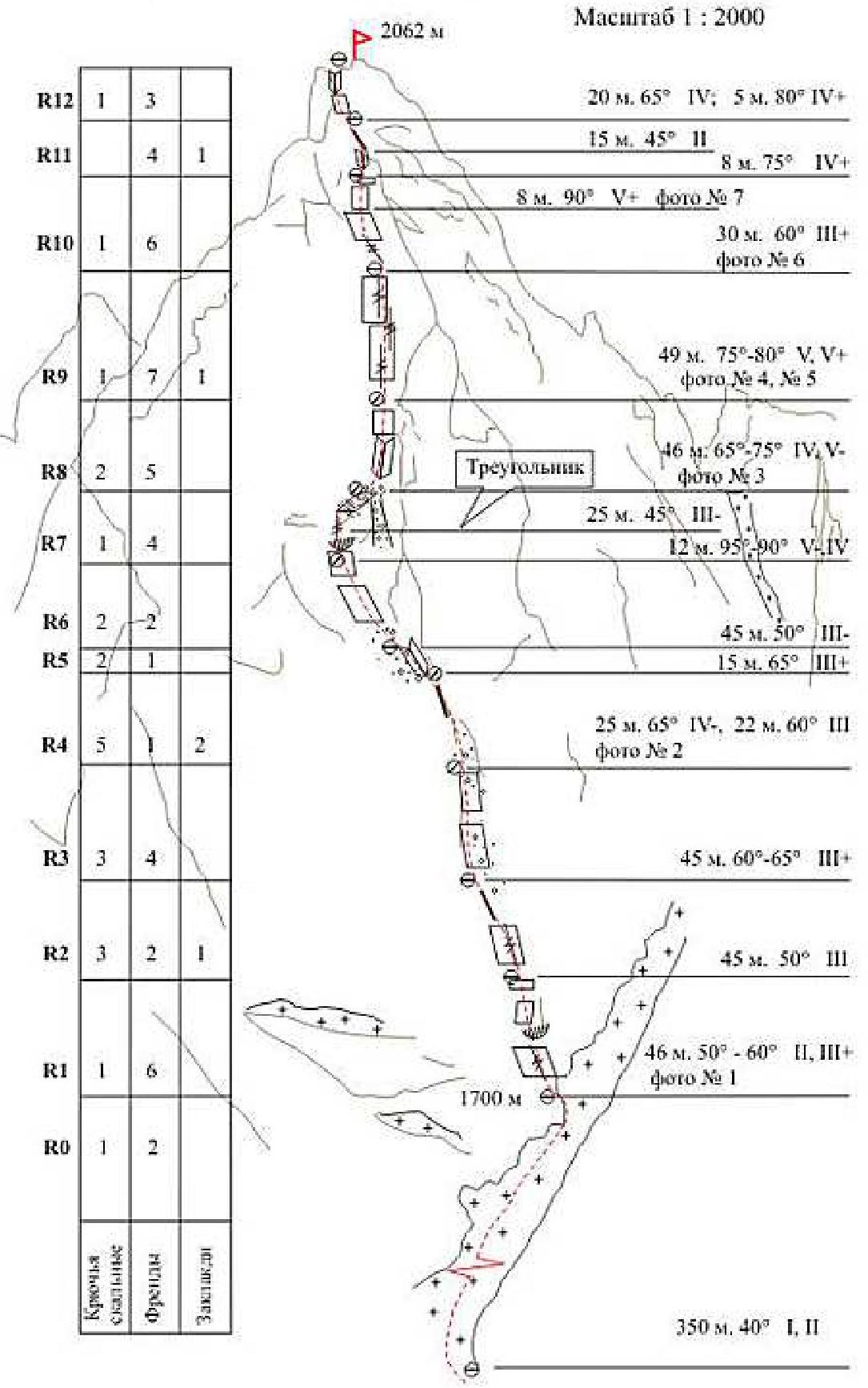
Route diagram in UIAA symbols
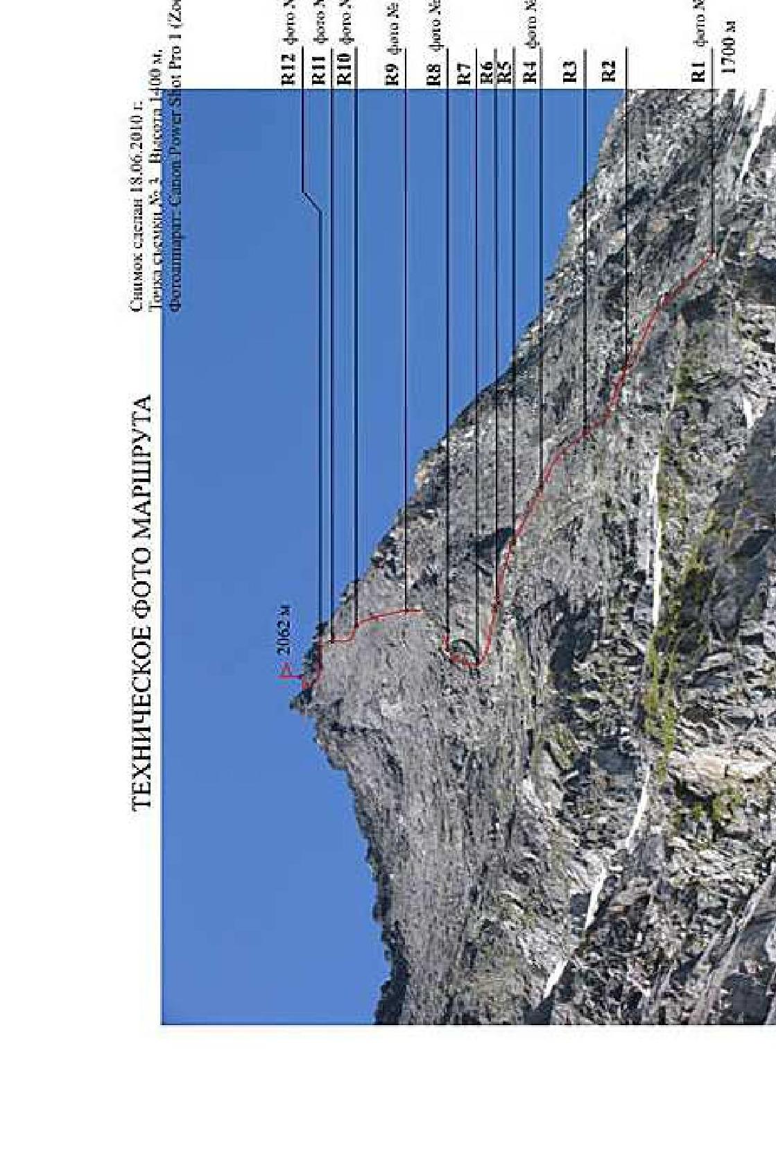
Technical photo of the route
The photo was taken on June 18, 2010.
Shooting point No. 3. Height 1400 m.
Camera: Canon Power Shot Pro 1 (Zoom)
| R12 photo No. 8 | R11 photo No. 7 | R10 photo No. 6 |
|---|---|---|
| R9 photo No. 4, 5 | R8 photo No. 3 | R7 |
| R6 | R5 | R4 photo No. 2 |
| R3 | R2 | R1 photo No. 1 |
| R1 photo No. 1 | 1700 m |
R – belay station, No. in sequence.
Description of the route by sections
Section R0
From the rocks, up the snowy couloir, straight up, about 350 m, approach the start of the route – a protruding rocky promontory turning into a counterfort above – the left face of the "triangle". Climb onto the promontory – here, on the talus platform, is a convenient place for organizing the first station (height 1700 m).
Section R1 (start of the rock part of the route, photo No. 1)
From the platform, up and left through an overlaying slab 46 m, 45-60°. Belay points – friends No. 3-5*. Station on a talus shelf** (friends No. 0, No. 4, No. 8).
Section R2
Left and up 15 m. Exit onto a wide, undefined counterfort and then up the counterfort 40 m.
Sections R3-R4 (photo No. 2)
The route then goes along destroyed slabs towards the left face of the "triangle". The path from station to station is best laid with deviations to the right and left to reduce the risk of the leader dislodging rocks into the zone of lower belay stations. Section 90 m, 60-65°, III-IV-. Belay points – chocks and friends No. 0-5, petal hooks, 2 channel hooks.
Section R5
From the station, 15 m up, bypassing the left face of the "triangle". Upper station – rock, channel hook.
Section R6
Then, straightforward climbing, along a wide deflection in no way towards the summit, slightly deviating left, to approach under the overhang (on the right is a wide chimney-couloir – do not enter, rockfall hazard). Under the overhang, the station will be protected from possible rockfall during the leader's further movement along the talus shelf at the end of the section. Station – friend No. 3, horizontal and channel hook.
Section R7
From the station through the overhang onto "slabs" straight up (climbing V-), exit onto an oblique talus shelf. Along the shelf, up and right, and not reaching the end of the shelf, climb onto a small balcony to divert the rope from the talus. Station – channel hook and two friends No. 0, No. 1.
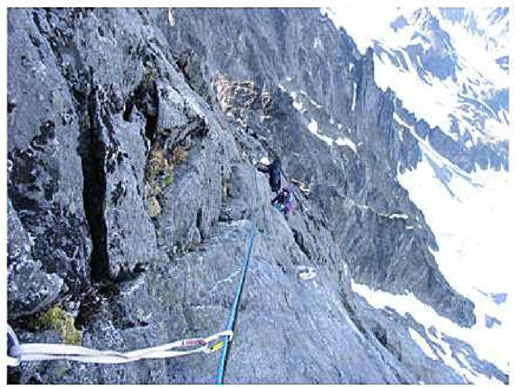
Section R8 (photo No. 3)
Traverse right and up 12 m, enter the inner corner (10 m). Climbing IV, IV+. Not reaching the end of the corner, move left onto the wall and up 8 m (V-) to a narrow shelf.
Belay points – friends No. 1-4. Station – ledge, hook, friend.
Section R9 (photo No. 4)
Then, up the wall towards the summit 48 m, 75° (without deviating right towards the counterfort), tense climbing – V, V+ along a vertical crack and small separations in a monolithic slab. Belay points – friends No. 0-5, hooks. Station – 3 friends No. 2-4 and a thin hook. In the station area, a hook with a Control Note is installed (photo No. 5).
Section R10 (photo No. 6)
From the station, along a diagonal crack, left and up 30 m towards a destroyed inner corner-gutter (photo No. 5) and then, not reaching the corner, straight up along its right side 8-10 m. 90° V+, exit onto a small triangular shelf convenient for a station. Belay points – friends No. 00-1. Station – channel hook, 2 friends No. 1, No. 3.
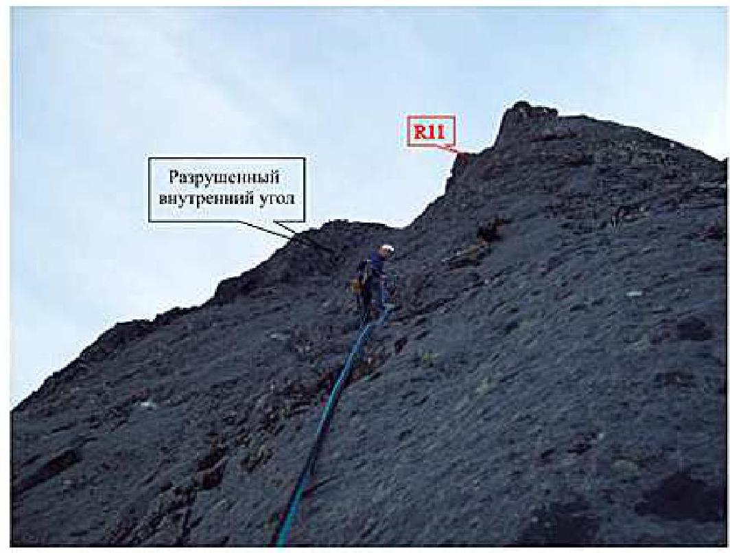
Section R11 (photo No. 7)
- From the platform, up the inner corner 8 m – exit onto the counterfort shoulder
- Along the counterfort, another 10-12 m up, towards the summit, to convenient ledges for organizing a station
- Belay points – friends No. 1-3
- Station – ledge and friend No. 0.
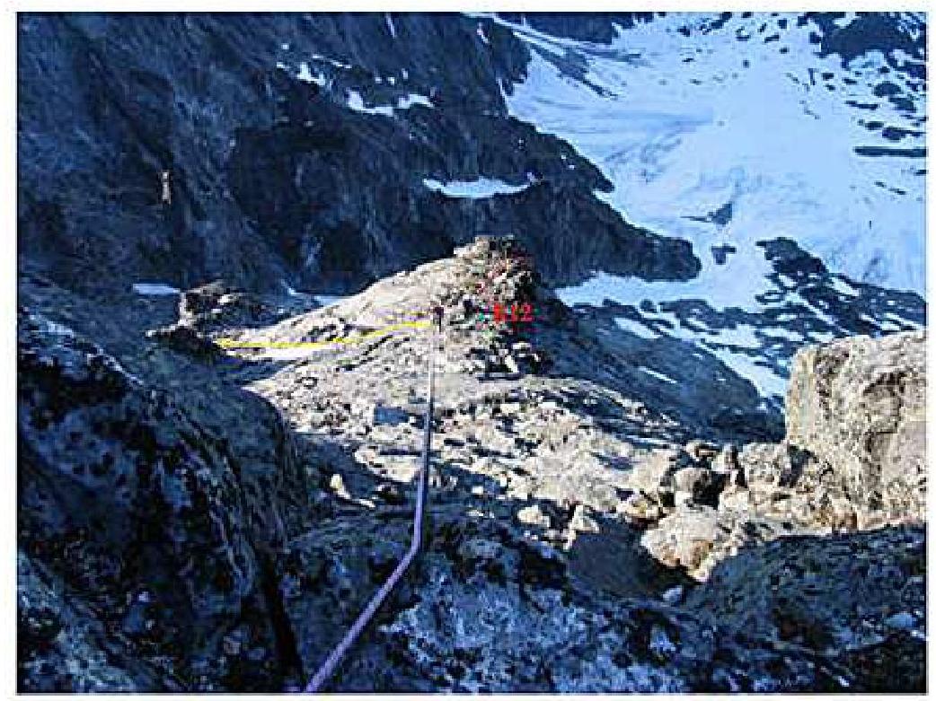
Section R12 (photo No. 8)
The final section is 20 m, climbing IV, IV+ along smooth rocks 65° with limited choices for belay points – exit onto the pre-summit saddle. Exit onto the saddle via an inner corner 5 m. 80°.
The summit is a flat platform 1.5 × 5 m, protected from the north-east by large rocks forming a natural wall about 2 m high, and from the north-west by a 3-meter rock – the summit point.
Descent from the summit via the 3B category route "From the north-west".
* The team used friends of the following size range:
| No. 00 – for cracks width 10-12 mm | |
|---|---|
| No. 0 – 12-15 mm. | No. 6 – 28-33 mm. |
| No. 1 – 14-18 mm. | No. 7 – 30-43 mm. |
| No. 2 – 18-23 mm. | No. 8 – 38-50 mm. |
| No. 3 – 20-25 mm. | No. 9 – 47-57 mm. |
| No. 4 – 24-30 mm. | No. 10 – 54-67 mm. |
| No. 5 – 28-37 mm. | No. 11 – 63-83 mm. |
** Here and below is a description of the organization of upper stations of the sections.
Photo No. 1
Section R1
The photo was taken from the station of section R1 on June 17, 2010.
Camera: Canon Power Shot Pro 1 (Zoom)
Photo No. 2
Section R4
Approach to the left face of the "triangle"
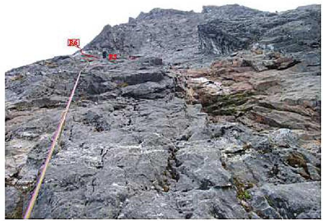
The photo was taken from the station of section R4 on July 6, 2009.
Camera: Canon Power Shot Pro 1 (Zoom)
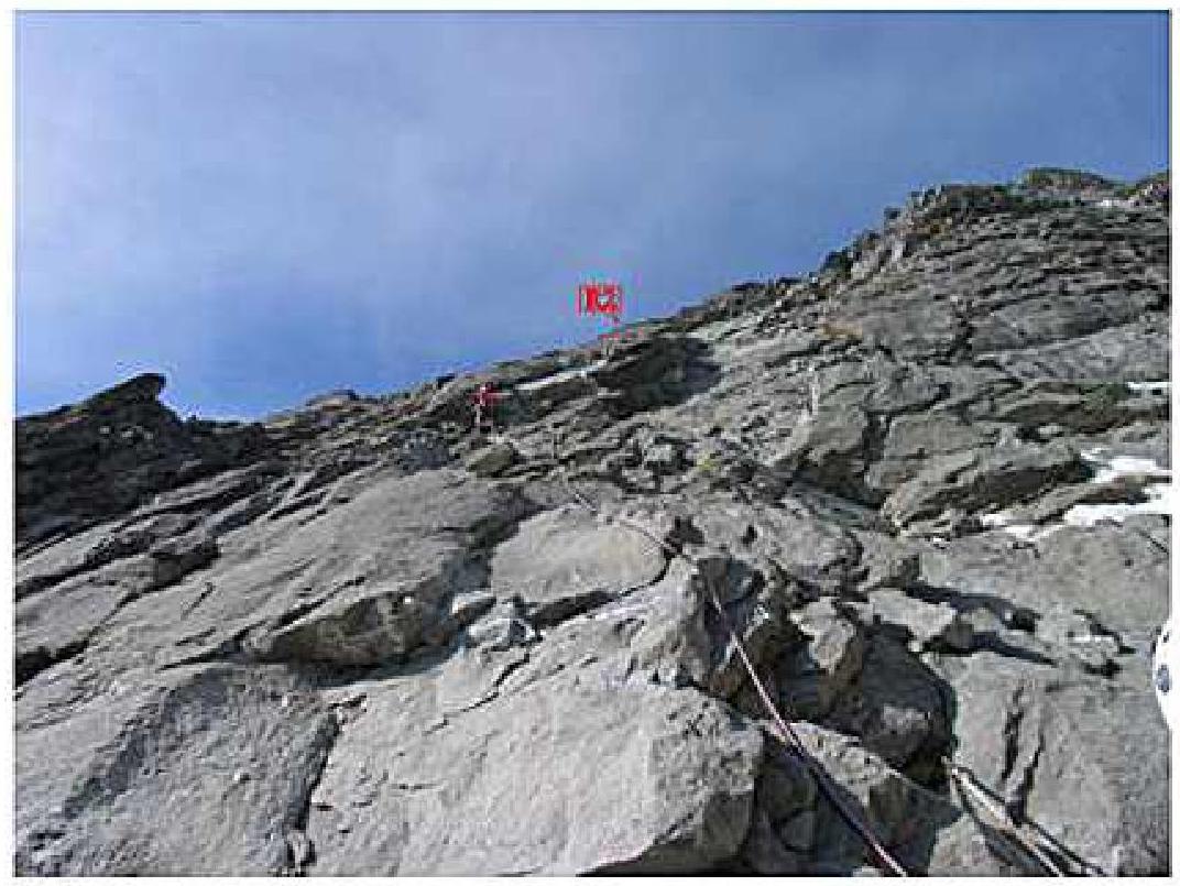
Photo No. 3
Section R8
Inner corner

The photo was taken from the station (on the talus shelf) of section R8 on June 17, 2010.
Camera: Canon Power Shot Pro 1 (Zoom)
Photo No. 4
Section R9
The photo was taken from the station of section R9 on June 17, 2010.
Camera: Canon Power Shot Pro 1 (Zoom)
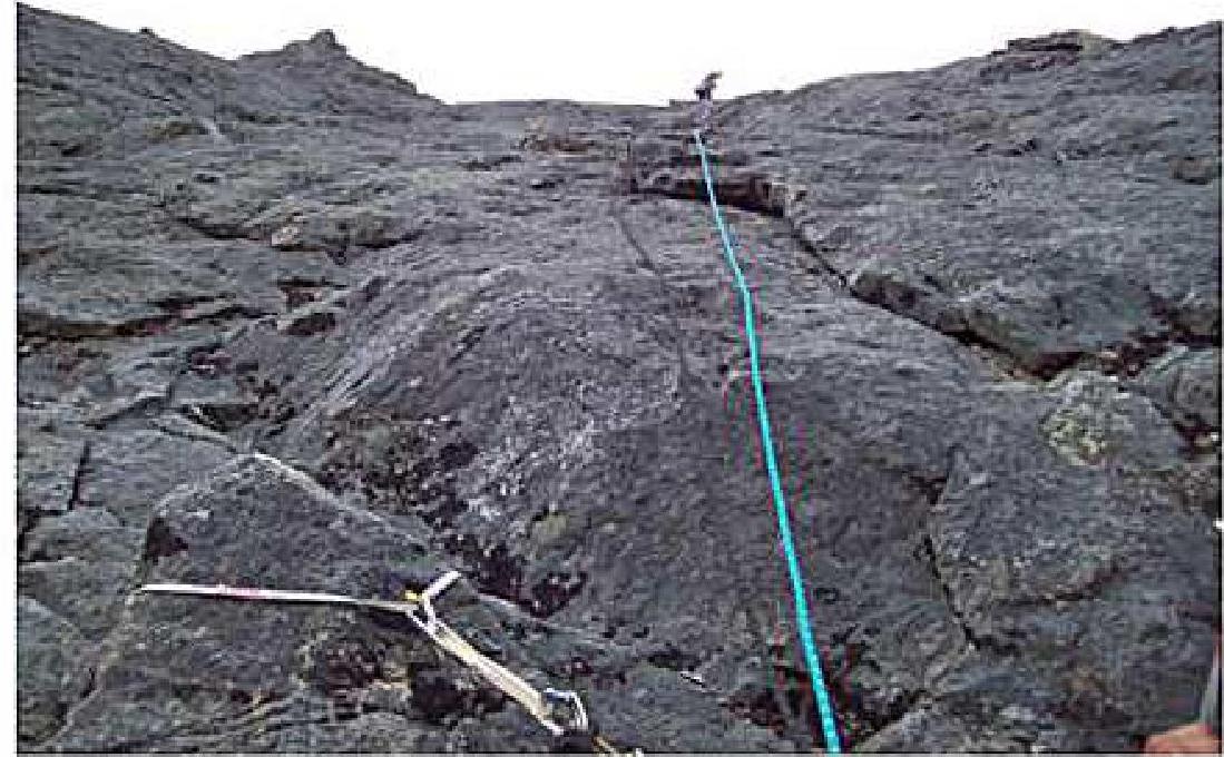
Photo No. 5
Exit to the station of section R10
The photo was taken from the rope of section R9 on June 17, 2010.
Equipment:
- Camera: Canon Power Shot Pro 1 (Zoom)
Photo No. 6
Section R10. View from the traverse to station R10
The photo was taken by the leader on section R10 on June 17, 2010.
Camera: Canon Power Shot Pro 1 (Zoom)
Photo No. 7
View from above down from station R11

The photo was taken from the station of section R11 on June 17, 2010.
Camera: Canon Power Shot Pro 1
Photo No. 8
Descent from the summit
The photo was taken from Main Peak on June 17, 2010.
Camera: Canon Power Shot Pro 1 (Zoom)
- "Via the north-eastern wall", I. Benedyuk 2010
- "From the north-west", 3B category of difficulty.
- I. Korbuh 1981 (descent route)