Ascent Log
- Ascent category - technical
- Ascent area - group of volcanoes 30 km from Petropavlovsk-Kamchatsky at 55° N
- Peak, its height, route - Kozelsky peak (2070 m), first western edge
- Proposed category difficulty - 3B
- Route description:
| # | Sections | Length | Average steepness |
|---|---|---|---|
| 1 | 2 | 3 | 4 |
| --- | ---------- | ------------- | ---------------- |
| 1. | Section 2 | 1060 m | 20–25° |
| 2. | Section 3 | 160 m | 40–50° |
| 3. | Section 4 | 120 m | 60–70° |
- Pitons hammered: rock - 2 pieces Wooden wedge - 1 piece
- Number of climbing hours - to complete the route from the start at 1400 m to the central summit at 2070 m - 6 hours
- No overnight stays.
- List of participants:
| # | Name | Rank | |
|---|---|---|---|
| 1 | 2 | 3 | 4 |
| --- | -------------- | ------------- | ------------- |
| 1. | Neverov V.N. | 1st sports rank | Leader |
| 2. | Loginov I.V. | 2nd sports rank | Participant |
| 3. | Meltyukhov V.A. | 2nd sports rank | — |
- Team coach - senior instructor, CMS Grikevich Stanislav Ivanovich
Brief explanation for the route passage
1. Approach
from Petropavlovsk to Kozelsky River by car, from Kozelsky River to glaciologists' hut at 800 m mark on skis 13 km. From glaciologists' hut up the Kozelsky glacier to the start of the route 2–3 hours (depending on glacier condition and snow amount).
- Time taken for the route is given for one rope team of 3 people - 6–7 hours. With more snow on the rocks and two or three rope teams, time will increase by 2–3 hours.
- Descent from the central summit down the wide southern snowy slope takes 1–1.5 hours.

Characteristics of sections, belay, passage
| # | Steepness | Length | Terrain characteristics | Difficulty | Condition | Weather | Belay: rock | Belay: wooden wedges | Belay: ice | Passage: rock | Passage: wooden wedges | Passage: ice |
|---|---|---|---|---|---|---|---|---|---|---|---|---|
| 1 | 2 | 3 | 4 | 5 | 6 | 7 | 8 | 9 | 10 | 11 | 12 | 13 |
| --- | -------- | ------------- | ----------------------------------------------- | --------- | ------------------ | ------------- | ----------- | -------------------- | ---------- | -------------- | ---------------------- | ------------------------------------------- |
| 1 | 70–80° | 40 m | rock walls up to 2–2.5 m | 4 | on ledges, snow | overcast, 0° | via ledges | from a platform | 4 | |||
| 2 | 40–50° | 40 m | rock slabs form an edge | 3 | on ledges, snow | overcast, 0° | via ledges | from a platform | 2 | |||
| 3 | 40–50° | 40 m | rock edge | 3 | on ledges, snow | overcast, 0° | via ledges | from a platform | via ledges | |||
| 4 | 70° | 40 m | inclined slabs | 4 | snow in crevices | overcast, 0° | via ledges | from a platform | 2 | 2 | ||
| 5 | 40° | 40 m | snow-covered rocks, steep firn slope | 3 | rocks in snow, hard firn | sunny, 0° | via ledges | from a platform | via ledges with ice axe | |||
| 6 | 45° | 40 m | rock edge of slabs 2–3 m high | 2 | rocks in snow | sunny, 0° | via ledges | from a platform | via ledges | |||
| 7 | 45° | 40 m | inclined rock slabs | 4 | rocks in snow | sunny, +2° | via ledges | from a platform | 2 | |||
| 8 | 30° | 60 m | rock edge, rocks destroyed | 2 | snow on rocks | sunny, +2° | via ledges | via ledges | ||||
| 9 | 25° | 1000 m | hard firn | 2 | firn | sunny, +2° | via ice axe | in crampons, self-belay via ice axe |
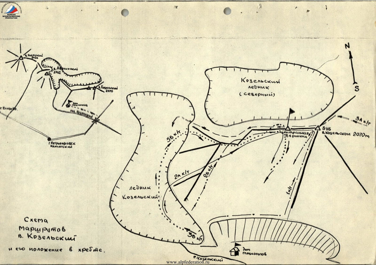
Diagram of Kozelsky peak routes and its position in the ridge.
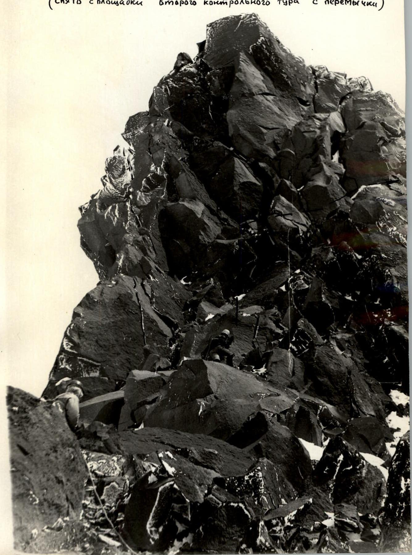
Section #6
(Taken from the second control tour platform on the saddle)