
I. ASCENT REPORT (2nd ascent)
- Ascent class — rock climbing
- Ascent area — Eastern Caucasus, northern spurs of the Main Caucasian Range
- Peak — Shalbuzdag Main, 4142 m, via the south face
- Proposed difficulty category — 4A
- Height difference — 300 m, length of sections with 5th difficulty category — 65 m, average steepness — 63°
- Rock pitons hammered in — 9, chocks placed — 26, runner protection loops hung — 8
- Number of moving hours — 8
- Korenn A.V. 2nd sports category, leader Konovalov Yu.V. 2nd sports category Nakhabtsev D.V. 2nd sports category Barikhin I.A. 2nd sports category
- Team coach Troshchinenko L.A. Master of Sports of the USSR
- Departure date: February 7, 1981, return date: February 8, 1981
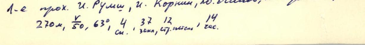
II. ASCENT REPORT to the peak Shelbuzdag Main (1st ascent)

- Ascent class — rock climbing
- Ascent area — Eastern Caucasus, northern spurs of the Main Caucasian Range
- Peak Shelbuzdag, height 4142 m, route via the south face
- Proposed difficulty category — 4A
- Height difference — 270 m, length of sections with 5th difficulty category — 50 m, average steepness — 63°
- Rock pitons hammered in — 4, chocks placed — 37, runner protection loops hung — 12
- Number of moving hours — 14
- Rumi Ilya Iosifovich II sports category, leader Korkin Igor Vasil'evich Master of Sports Osipov Yuri Afanas'evich II sports category Chernov Vladimir Ivanovich II sports category
- Team coach — Kolchin A.A. Master of Sports
III. ROUTE DESCRIPTION
Table of main characteristics of the ascent route
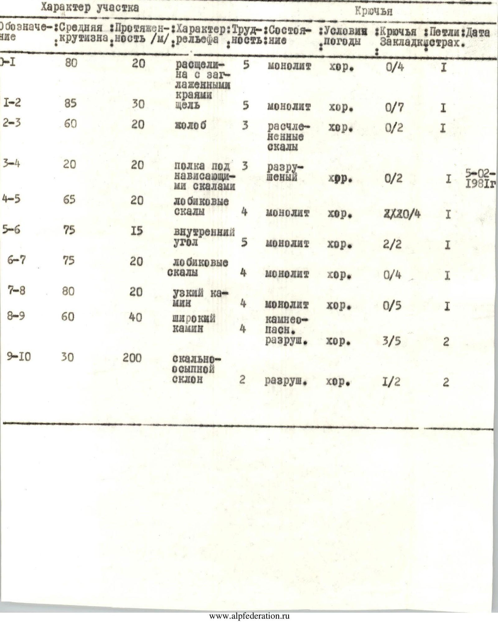
| Designation | Average steepness | Length, m | Terrain characteristics | Difficulty | Condition | Weather conditions | Pitons | Loops | Chocks | Protection | Date |
|---|---|---|---|---|---|---|---|---|---|---|---|
| R0–R1 | 80° | 20 | crevice with smoothed edges | 5 | monolithic | good | 0 | 4 | 1 | ||
| R1–R2 | 85° | 30 | crack | 5 | monolithic | good | 0 | 7 | 1 | ||
| R2–R3 | 60° | 20 | groove | 3 | fragmented rocks | good | 0 | 2 | 1 | ||
| R3–R4 | 20° | 20 | ledge under overhanging rocks | 3 | destroyed | good | 0 | 2 | 1 | February 5, 1981 | |
| R4–R5 | 65° | 20 | forehead rocks | 4 | monolithic | good | 2 | 0 | 4 | 1 | |
| R5–R6 | 75° | 15 | inner corner | 5 | monolithic | good | 2 | 2 | 1 | ||
| R6–R7 | 75° | 20 | forehead rocks | 4 | monolithic | good | 0 | 4 | 1 | ||
| R7–R8 | 80° | 20 | narrow chimney | 4 | monolithic | good | 0 | 5 | 1 | ||
| R8–R9 | 60° | 40 | wide chimney | 4 | rockfall hazard, destroyed | good | 3 | 5 | 2 | ||
| R9–R10 | 30° | 200 | rocky-scree slope | 2 | destroyed | good | 1 | 2 | 2 |
The approach to the route from the village of Kurush passes through scree ridges in the direction of the Main peak of Shelbuzdag. Having reached the scree of the southeastern counterfort, turn left and move along the walls to the South face. The ascent route can be divided into three parts: the wall part — sections R0–R4; the belt of steep forehead rocks — sections R5–R9; the scree slopes of the peak — section R9–R10. The route is logical. Deviation from the route to the left is limited by deep steep grooves, deviation to the right in the lower part of the route is limited by sheer and overhanging walls, and in the upper part — by steep grooves.
The wall part of the route is a steep wall, 50 m wide, bounded on the right by the sheer walls of the southeastern counterfort, and on the left by the western wall. This part of the route is composed of yellowish limestone. In the right lower part of the wall, there is a ledge, and in the left part, a crevice is visible, going up from the scree. This is the start of the route. Under the start of the route on the scree, a cairn is built. After passing the crevice, move up to the left to the fork of three cracks (R0–R1). Climb up the middle crack (R1–R2). Climbing is difficult, the crack has smoothed edges, and its upper part, not visible from the start of the crack, overhangs. Galoshes are recommended. At the end of the crack, there is a small pointed shard, through which it is convenient to organize protection with a tape loop. From the end of the crack, exit to the left along the groove to a ledge under overhanging rocks (R2–R3) and along it to the left around the corner to the control cairn (R3–R4). From the control cairn, climb up the forehead rocks (R4–R5). Then, deviating to the right, move along the sheer inner corner (R5–R6), after which move 20 m to the right along the next section of forehead rocks (R6–R7). From here, the general direction of movement is to the right of the gray-red rocks with black vertical streaks. A vertical narrow chimney (R7–R8) leads to the beginning of a wide chimney, going to the right with a turn to the left. The chimney is formed by large rock blocks and ends under overhanging rocks, in which there is a hole-passage, leading to a scree slope (R8–R9). Rockfall hazard. Along the scree slope, bypassing the rock sentinel to the right, exit to the scree slope of the peak and along it to the peak (R9–R10).
Descent from the route
Descent via route 1B category of difficulty along the eastern ridge.
Return to the village of Kurush via the ascent path.
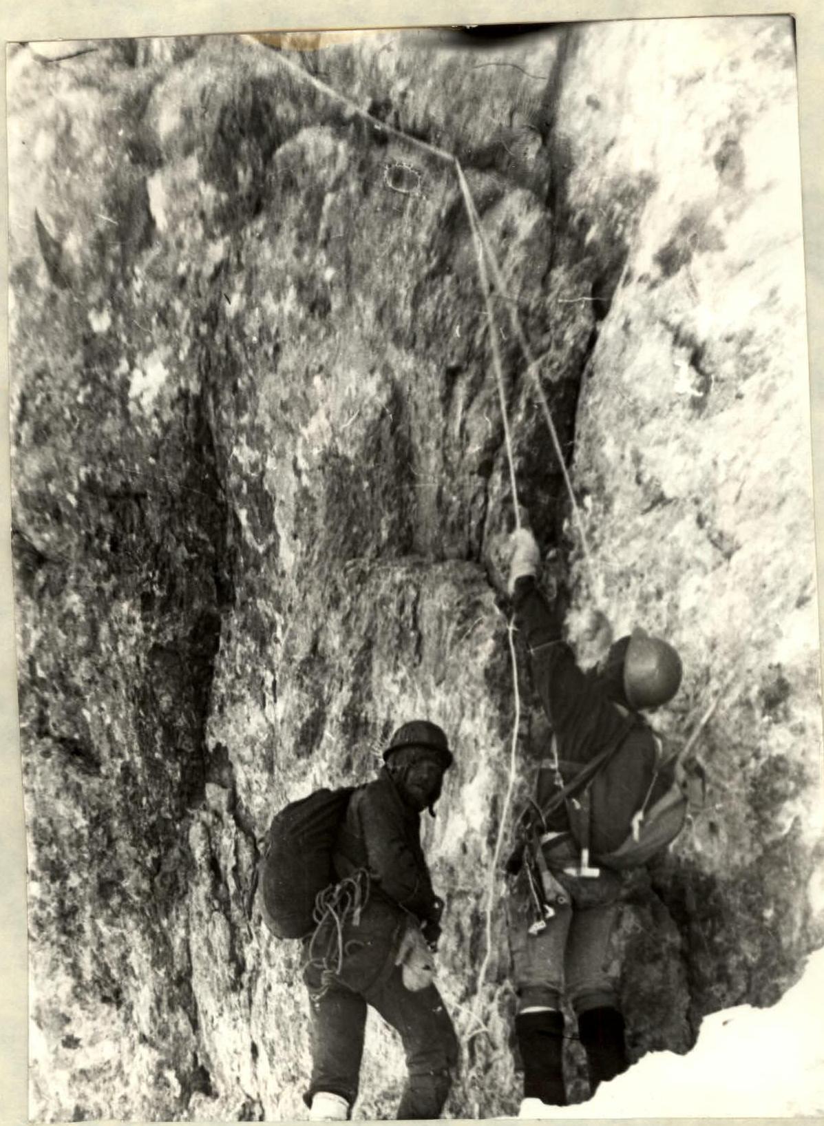
Start of the route. Crevice (R0–R1)
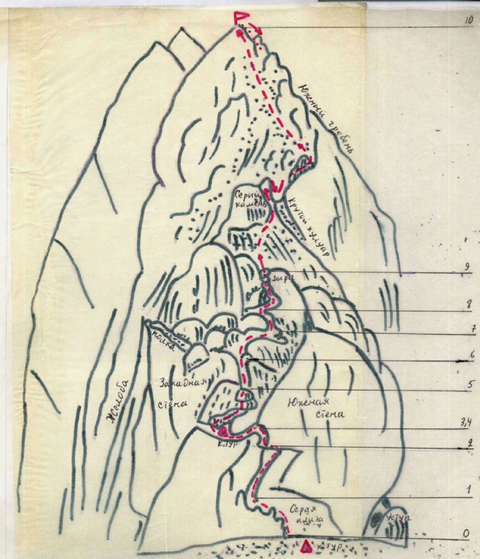
Map of the route to the peak Shelbuzdag via the south face
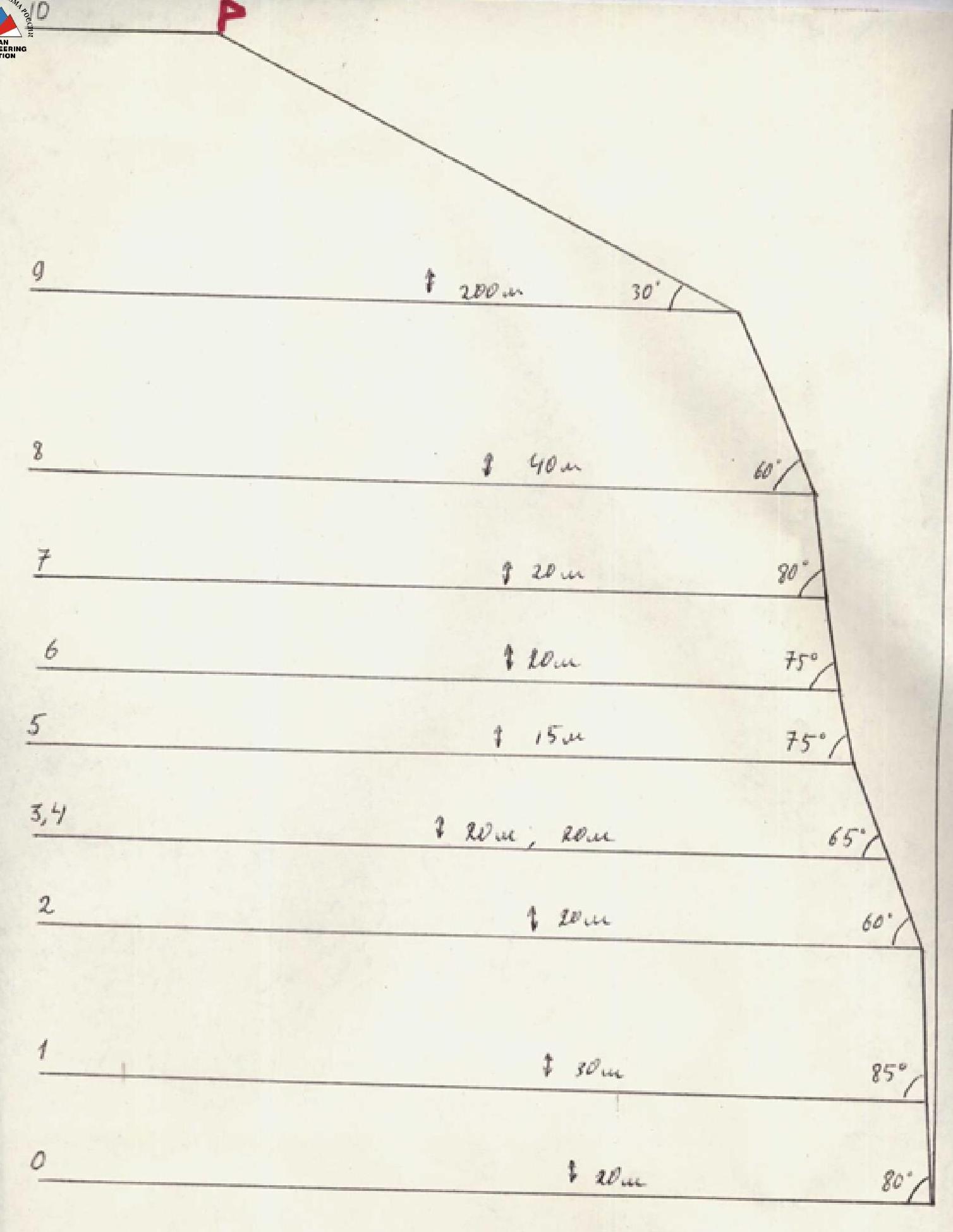
Profile of the route to the peak Shelbuzdag Main via the south face
Comments
Sign in to leave a comment