
Ascent Passport
- Ascent class
- Ascent area
- Peak, its height and ascent route
- Proposed difficulty category
- Route characteristics:
- Number of pitons hammered for belay: rock, ice, bolted
- Number of travel hours
- Number of overnight stays and their characteristics
- Surname, name, patronymic of the leader and participants, their sports qualification
- Krasnopolsky Yuri — 1st sports category
- Mikirov Egor Sergeevich — III category
- Malikov Yuri Borisovich — III category
- Musaev Abdul Magomedovich — III category
- Team coach Timoshin Mikhail Egorovich
- Date of departure and return November 9, 1978
rocky No. 29 (East Caucasus)
Shalbuzdag 4150 m via the eastern couloir
1B. Elevation gain 500 m, average steepness 35°, length of sections of 1st cat. diff. — 750 m; 2nd cat. diff. — 110 m, 3rd cat. diff. — 0.
2 0 0 5
no overnight stays
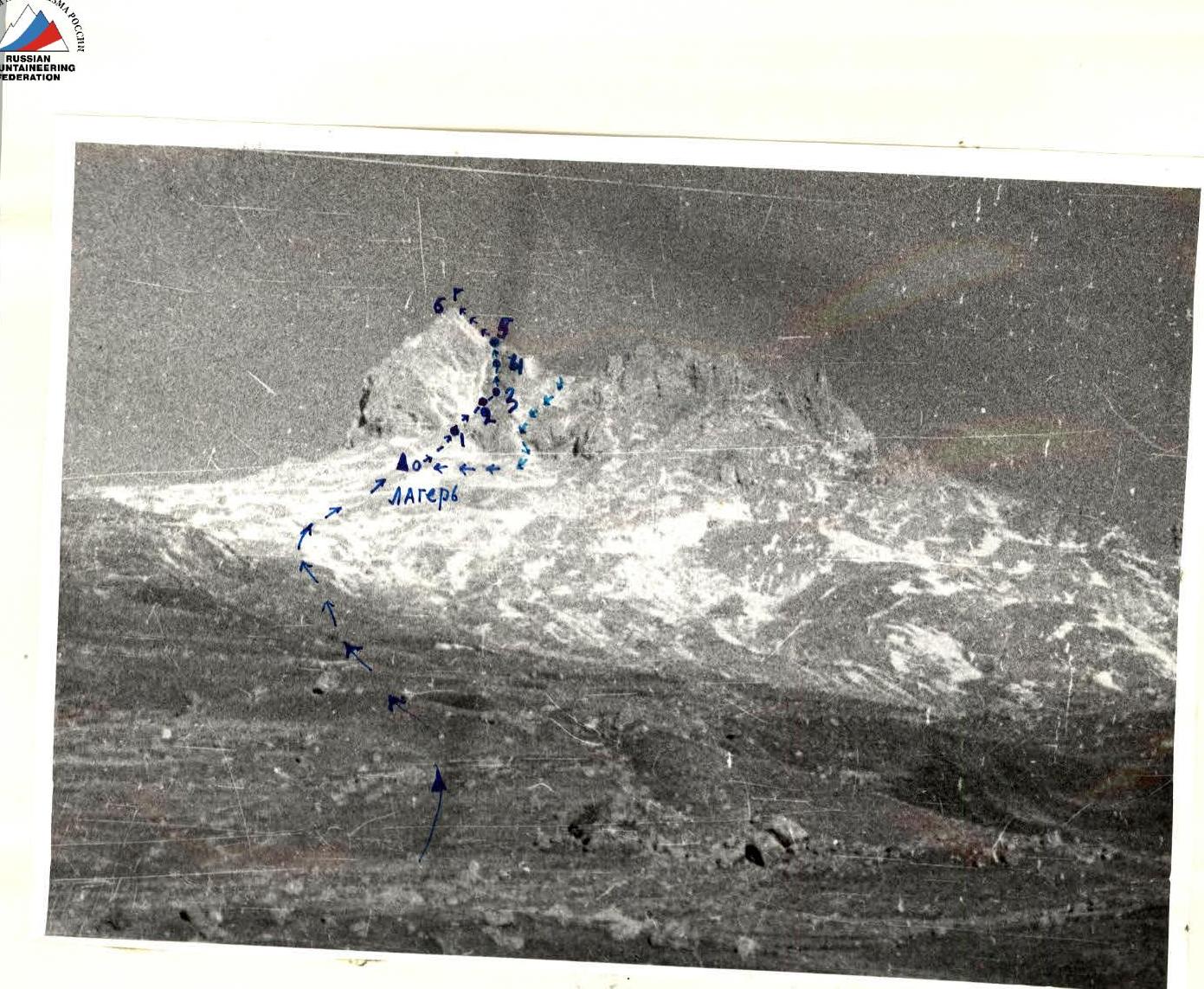 Scheme of the ascent area to Shalbuzdag (4150 m) via the Eastern couloir. 1B cat. diff. Approximately.
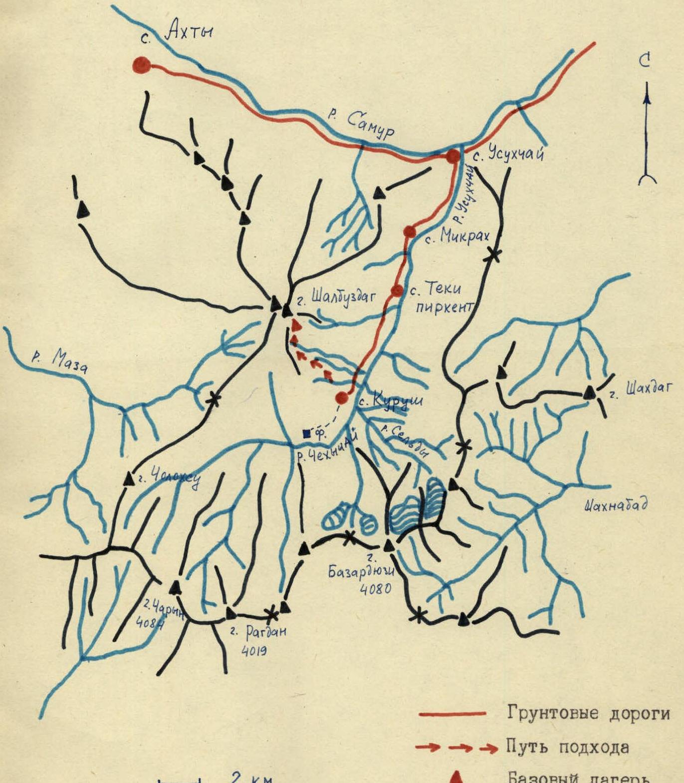
Description of the approach to the route on Shalbuzdag via the Eastern couloir 1B cat. diff. approximately
From the village of Kurush, Akhtynsky district, DASSR, located on the slope of Shalbuzdag at an altitude of 2500 m:
- Follow the trail along the stream up the slope.
- The trail leads to a gentle grassy slope, intersected by numerous gullies.
- Along the slope to the left of the ridge, leading under the steep red scree of the main summit of Shalbuzdag.
- From the village of Kurush to the ridge 2.5–3 hours.
- Along the ridge to the left up, past the wall of the Shalbuzdag cirque, in the direction of the left scree couloir.
- 100 m before the steep red scree — a bivouac site, a stream runs.
- From the village of Kurush 4–4.5 hours.
Table of route sections to the summit of Shalbuzdag (4150 m) via the eastern couloir 1B cat. diff.
approximately
| Character of the section | Pitons | ||||||||||
|---|---|---|---|---|---|---|---|---|---|---|---|
| Date | Designation | Average steepness in degrees | Length, m | Character of relief | Difficulty | Condition | Weather conditions | Speed | Rock | Ice | Bolt |
| 1 | 2 | 3 | 4 | 5 | 6 | 7 | 8 | 9 | 10 | 11 | 12 |
| November 9, 1973 | 1 | 30 | 300 | Scree | 1 | Large stones | Good | Simultaneously | |||
| —"— | 2 | 40 | 200 | Belts | 1 | Destroyed rocks | — | Simultaneously, with an outcrop | — | ||
| —"— | 3 | 50 | 30 | Couloir | 2 | Monolithic | — | 1 piton | — | — | |
| —"— | 4 | 40 | 200 | Scree couloir | 1 | Frozen scree, belts of destroyed rocks | — | Simultaneously, with an outcrop | |||
| —"— | 5 | 60 | 30 | Couloir | 2 | Destroyed rocks | 1 piton + with an outcrop | — | |||
| —"— | 6 | 40 | 100 | Ridge | 1–2 | Destroyed rocks | With an outcrop | — |
Description of the route to Shalbuzdag (4150 m) via the eastern couloir 1B cat. diff.
approximately
From the bivouac:
- up to the right along the scree in the direction of the large red couloir;
- then to the left onto the rocks, partially destroyed;
- move along the rocks to the narrow rocky couloir;
- here 30 m of simple category rocks (“Rockfall!”);
- further along the steep scree couloir to the ridge of the main summit of Shalbuzdag;
- exit to the ridge along destroyed rocks of simple category (“Rockfall!”);
- along the ridge to the left up to the summit;
- here is the trig point.
Time from the bivouac: 5 hours.
Descent:
- along the ridge on the ascent path to the source of the narrow couloir;
- from here to the left — 30 m of sport descent to the snowy slope;
- along the slope into the Shalbuzdag cirque;
- further in the direction of two “red” rocky fingers — into the right scree couloir;
- to the wide scree under the wall of the cirque;
- along the scree — to the bivouac.
Descent time: 2.5–3 hours.

Photo of Shalbuzdag from Kurushsky pass.
Comments
Sign in to leave a comment