
Ascent Passport
I. Ascent class — rock climbing 2. Ascent area — 2.9 Eastern Caucasus 3. Peak, its height, and ascent route — traverse I-st Western Erydag (4020 m) — Main Yaru-dag (4110 m) from Kurush pass (3925 m) 4. Proposed difficulty category — 2A 5. Route characteristics: elevation gain — 920–1010 m
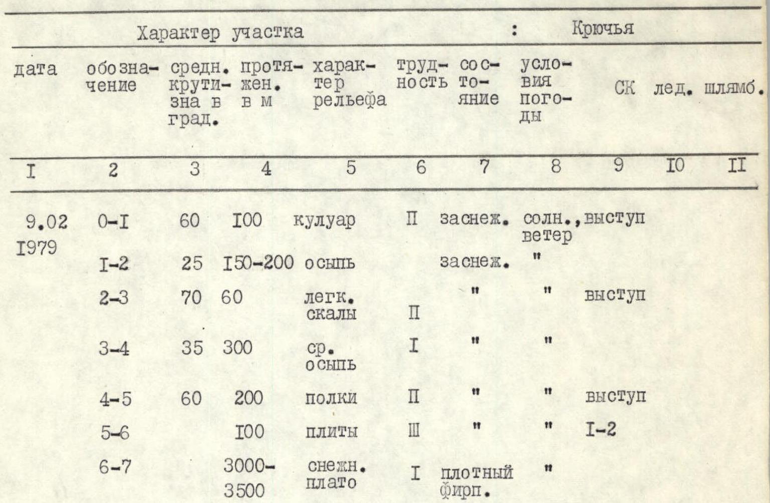
average slope — 50–60°, length of sections: R1 — 100, R2 — 150–200, R3 — 60, R4 — 300, R5 — 200, R6 — 100, R7 — 3000–3500 m.
- Pitons hammered: for belaying, for creating I.T.O.
rock — 0, ice — 0, bolt — 0
- Number of climbing hours — 7 hours
- Number of nights and their characteristics —
comfortable night at Kurush pass
- Surname, name, patronymic of the leader and participants, their sports qualification:
Nosov A.P. — MCMSK. Skridlaite G.V. — 3rd sports category. Nezametdinov A.B. — MS. Los S.A. — 3rd sports category. Abrosimov B.I. — 3rd sports category. Grinko A.N. — 3rd sports category. Davydov A.S. — 3rd sports category. Voskotrub P.V. — 3rd sports category. Mikheev V.A. — 3rd sports category. Kovtunovich P.Yu. — 3rd sports category. Tovetenko A.Yu. — 3rd sports category. Suldin Yu.A. — 3rd sports category.
- Team coach — Nezametdinov A.B.
- Date of departure and return — February 9, 1979
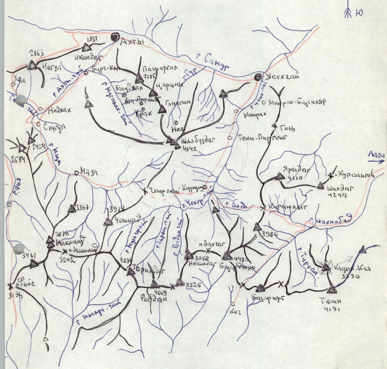
 Area map
Table
Description
of the route (traverse) I-st Western Erydag (4020 m) — Main Yaru-dag (4110 m) from Kurush pass 2A cat. dif. (first ascent)
The Yaru-dag massif is a plateau above sea level, raised more than 3.5 thousand meters, with steep walls on the north, west, and east. To the south, towards the Kurush pass, the plateau descends in a cascade of rock formations.
The ascent begins from the village of Kurush, to Kurush pass 3.5–4 hours.
From the night bivouac under Kurush pass, a narrow rock couloir is visible on the left. At the base of the couloir is a large cairn. The route goes through the couloir for 100 m along easy to moderate rocks. The presence of ice complicates the passage of the rock terrain. At the top of the couloir, there is a 2 m high wall.
Further, the route passes along a gentle scree slope, leading through 150–200 m to the second rock barrier, which is overcome directly in the right part along a diagonal rock ledge. Climbing easy rocks — 60 m.
Further, the route passes along wide scree slopes towards the I-st Western peak of Yaru-dag, which is bordered by an extended, raised barrier 200–250 m high, dropping to the south, forming the third step of the cascade. To the right of the peak, a rock couloir is visible, through which one can ascend to the upper plateau and then to the peak. It is more interesting and safer to pass to the left, along the rock ledges, and then along the slabs.
The length of the ascent to the 2nd Western peak: 300–350 m.
Features of the passage:
- Easy climbing alternates with sections of moderate rocks.
- Slabs are overcome on.
At the peak:
- Built a cairn.
- Left a note.
Transition from the first Western peak:
- Straight to the west to the Main peak.
- Walking time: 1.5–2 hours.
At the Main peak:
- Also a cairn.
- Also a note.
Descent to the southwest into a rock canyon formed by two stacks of towers of the second rock cascade, and further along the scree to Kurush pass — 2 hours.
From Kurush pass and back, the ascent takes 7–8 hours.
Comments
Sign in to leave a comment