Climbing Area: Eastern Caucasus, Bishiney Ridge, Charodinsky District, Dagestan ASSR.
MOUNT BISHINEY (4106 m), (Vishiney, 4043 m) combined route via the northern ridge, category 2A difficulty.
Group Composition:
leader — Basriev Zakir A. — Candidate Master of Sports, participants:
- Akhmedkhanov Kamil E. — 2nd sports category
- Pashuk Evgeny G. — 3rd sports category
- Leonov Petr G.
- Kozorezov Evgeny F.
- Nikhyaev Ruslan K.
- Nikamagomedov Ziyautdin Z. — badge holder
- Rassudishkin Sergey N.
- Moiseev Samuil I.
- Gashimov Gadzh G.
- Dolgikh Elena A.
Mount Bishiney (4043 m), listed in the "Classification Table of USSR Peaks" since January 1, 1949, is actually known as Mt. BISHINEY-DZHENOL-SHUP (4106 m) according to updated data (topographic maps, "Geography of Dagestan ASSR" by K. Gyul et al., 1959, and local toponymy).
Mount Bishiney (commonly abbreviated) is the highest point of the eponymous ridge and is located slightly south of 42° north latitude in the heart of highland Dagestan. The Bishiney ridge, together with the Taklik, Nukatl, Dyultydag, and Saladag ridges, form a complex Taklik mountain node, characterized by high elevations and glaciation.
The western slopes of the peak descend to the Oysor River, while the eastern slopes and ridges abut the floodplain of the Risor River. These rivers are the sources of the major Dagestan river, Kara-Kaitsu. Bishiney features significant glaciation:
- to the northwest lie two glaciers — Bol. Bishiney and Oknob, feeding the Oknobor River;
- to the northeast lies a small cirque glacier, East Bishiney;
- south of the peak is the Mal. Bishiney glacier.
The last two glaciers give rise to the Bishiney River, a left tributary of the Risor.
The northern boundary of the Bishiney massif is the Bishiney-2 pass (about 3520 m), while the southern boundary is the South Bishiney pass (about 3680 m). Approximately one kilometer south of the highest point of the massif lies the second (southern) peak of Bishiney, reaching an elevation of 4050 m.
Geologically, the peak is composed of:
- black shale with significant outcrops of gray sandstone (northern and northwestern walls);
- quartz vein interlayers.
Technical Description of the Route
The base (assault) camp is located one kilometer from the confluence of the Dartsа River with the Risor River, in the mouth of the Dartsа gorge, on a green, flat terrace on the left bank of the river.
The location is convenient, windless, with views of Mt. Lartsa (3906 m). The meadow's elevation is about 2520 m.
Approach routes to the camp are described in the category 2B route to Mt. Lartsa.
From the camp, ascend the Dartsа gorge to the confluence of the Basalakhara stream (right tributary of Dartsа). Cross the Dartsа River (slippery rocks!). Continue along a faint trail:
- initially across shale rocks;
- then up steep grassy slopes (45°–50°);
- exit to the edge of the Basalakhara plateau, near a small lake (1 hour 20 minutes from the camp).
Traverse the central snow-covered part of the plateau towards the eponymous pass. Ascend the pass directly up the steep snow slope (up to 40°) (avalanche danger on the right!). Reach the Basalakhara pass (3440 m, 3 hours 30 minutes from the camp) slightly above the saddle.
From the pass, ascend to the right up the broken shale ridge (up to 35°). Reach the "Uzlovaya" peak (about 3580 m), located on the axial part of the Bishiney ridge between the Bishiney-1 and Bishiney-2 passes. The time from the pass is 1 hour. Tie in here. Traverse the sharp snow ridge south of "Uzlovaya" with alternating belay via ice axe (cornices!) and descend to the Bishiney-2 pass (about 3520 m) towards a severely broken rock wall (12 m); 30 minutes from "Uzlovaya".
Ascend the 60°–70° rocks of moderate difficulty (belay via protrusions! ice screw!) to a ledge, then 180 m up the 60° shale "Knife" (alternating belay via protrusions!) to a depression in the ridge (about 3700 m). The time from the Bishiney-2 pass is 2 hours.
From the depression:
- ascend 220 m up the steep snow ridge (cornices! alternating belay via ice axes!);
- reach a characteristic bend in the ridge with rock outcrops and a short western counterfort (about 3920 m).
Continue along simple rocks, sometimes on short snow sections of the ridge, to its steep ascent, which terminates in a massive "North Wall" above the East Bishiney glacier. Move along the rocky edge of the "North Wall" (45°–50°) (simultaneous belay!) towards the sub-summit (about 4040 m). The time from the depression in the ridge is 1 hour 30 minutes. From here, ascend a gentle, broken shale ridge to the summit in 30 minutes. A cairn marks the summit, elevation 4106 m.
The descent via the ascent route takes 4 hours. Alternatively, consider descending from the summit shale "knife" to the right onto a steep firn field. The steepness on the descent is up to 40°–50° (belay via ice axe!). Traverse the snow slope to the left, exiting onto the Basalakhara pass.
The entire ascent takes 13 hours, with 9 hours spent on the ascent. The average steepness of the route is 21°.
Recommendations for Climbers
- Number of participants — 4–12 people.
- Initial bivouac — mouth of the Dartsа gorge or Basalakhara plateau;
- Departure time from bivouac — between 3:00 and 4:00
- Equipment for 4 people — main rope 2 × 40 m;
- ice screw — 1–2;
- rock hammer — 2;
- Bivouac locations — Basalakhara plateau and Bishiney-2 pass.
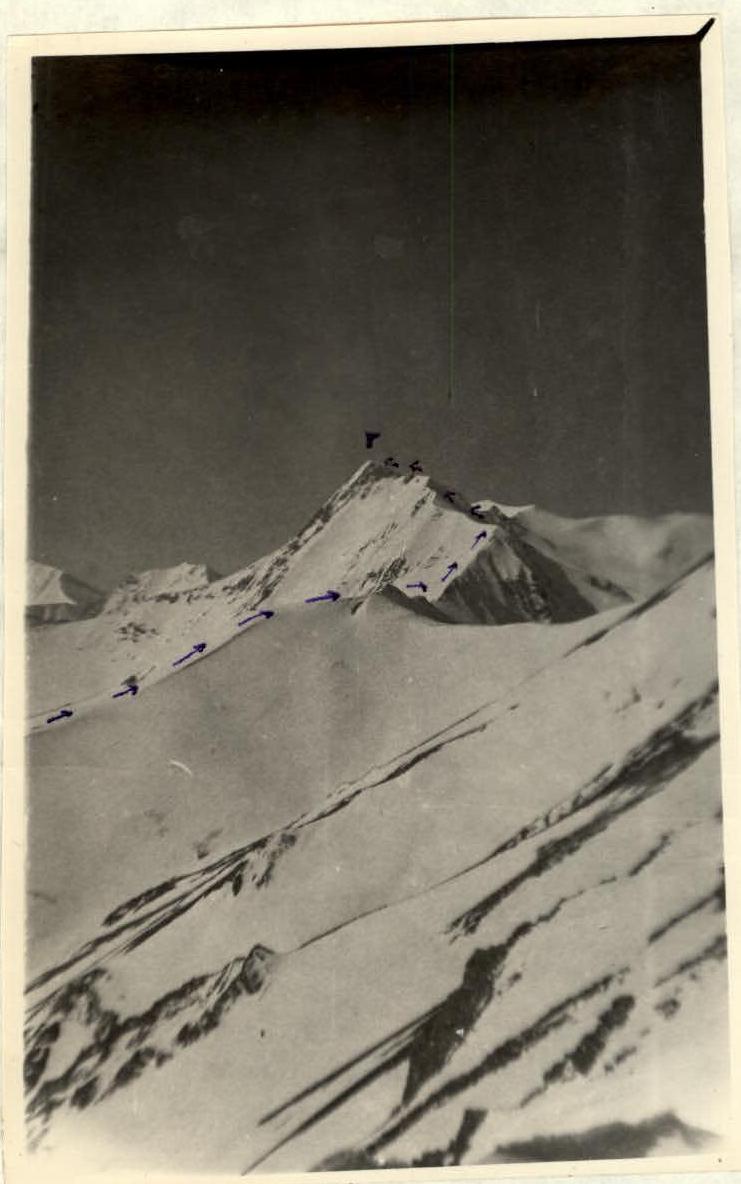
North ridge of Mt. Bishiney 4106 m (photo from the ridge of Mt. "C" Dartsа).
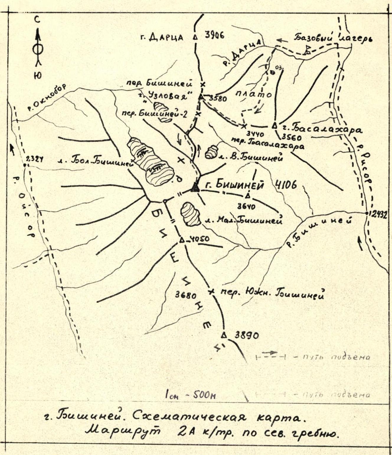
Mt. Bishiney. Schematic map. Category 2A route via the north ridge.