Ascent Report
- Area 2.9. From Krestovy Pass to Shaviklde Peak
- Gaikomd (C), 3100 m, via the left edge of the Southwest Ridge
- Proposed — 4B category of difficulty, first ascent
- Route type: rock
- Height difference: 690 m
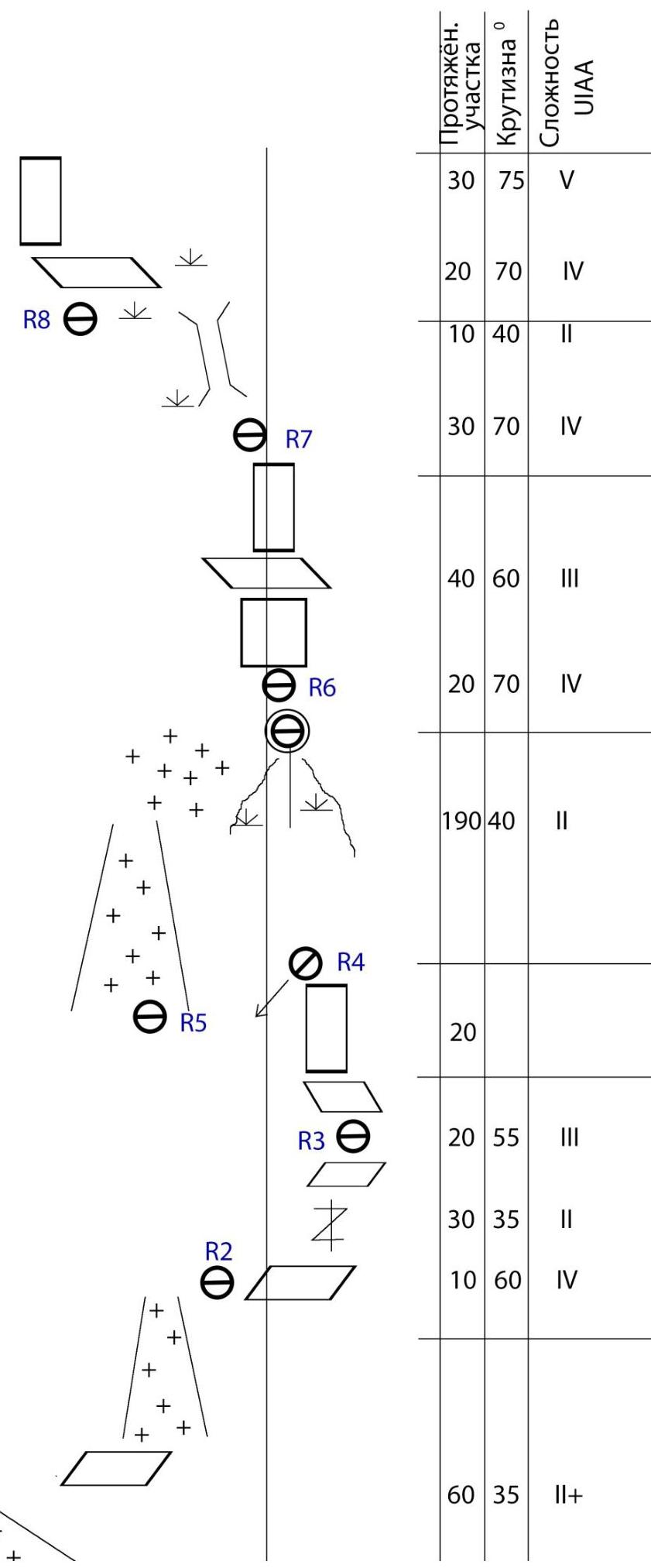
Route length: 805 m. Length of sections:
- I category of difficulty — 35 m
- II category of difficulty — 445 m
- III category of difficulty — 100 m
- IV category of difficulty — 120 m
- V category of difficulty — 105 m
- VI category of difficulty — 0 m
Average steepness: wall section — 65°; entire route — 60°.
- Insurance points used:
Total/ITO:
- 70/0 rock pitons
- 17 закладные элементы (placed elements)
- 53 bolt pitons
- 0 insurance points left on the route
Insurance points left on the route:
- Total — 2
- Rock pitons — 2
- Team's walking hours:
20 hours, 2 days, with 13 hours, 2 days of work on the route
- Team leader:
Donskov Andrey Mikhailovich, 1st sports category
Team members:
- Tokhyan Olesya Artemovna, 1st sports category
- Coach:
Motienko Nikolai Ilyich, Candidate Master of Sports, instructor 1st category, certificate No. 754
- Base camp setup, cargo delivery: November 24, 2015
Route started: 7:30 AM, November 25, 2015. Summit reached: 2:10 PM, November 26, 2015. Return to base camp: 9:10 PM, November 26, 2015. Descent from the summit: via the ascent route
- Team from the North Caucasus Regional Rescue Team of the EMERCOM of Russia №12. Responsible for the report:
Donskov A.M. phone: +7-962-017-82-09
donskov91@mail.ru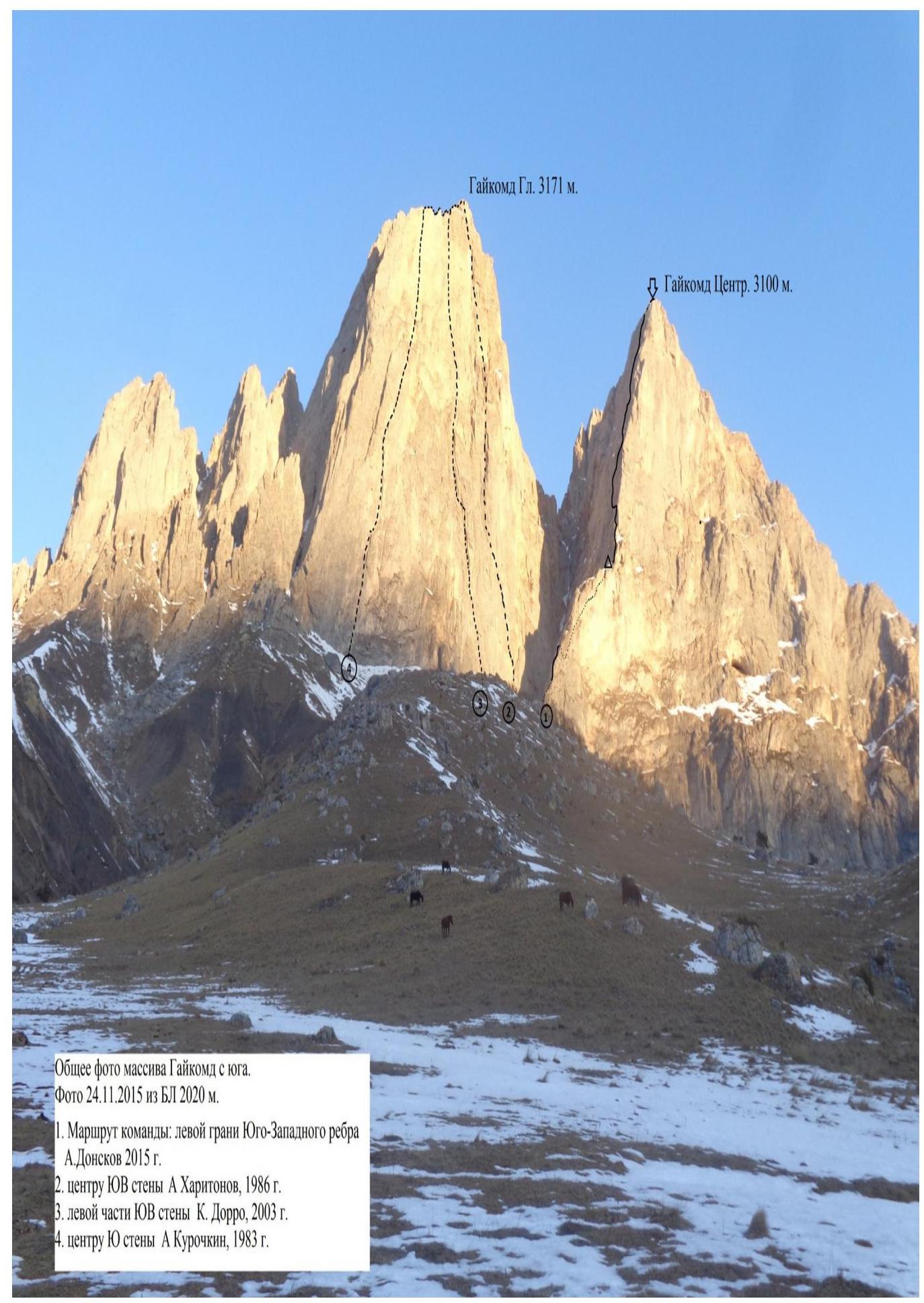
General photo of the Gaikomd massif from the south. Photo taken on November 24, 2015, from base camp at 2020 m.
- Team's route: left edge of the Southwest Ridge. A. Donskov, 2015
- Center of the Southeast wall. A. Kharitonov, 1986
- Left part of the Southeast wall. K. Dorro, 2003
- Center of the South wall. A. Kurochkin, 1983
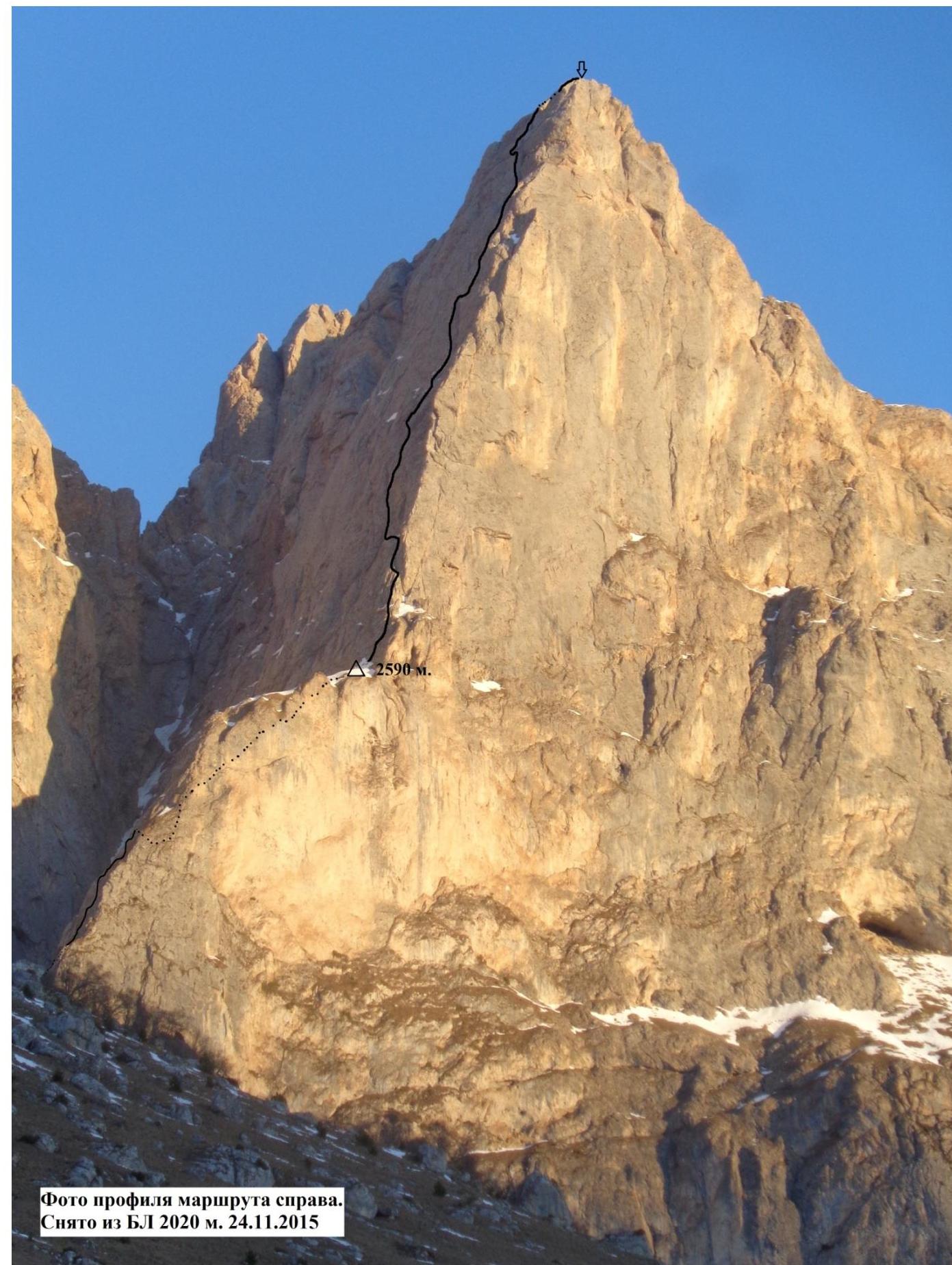
Photo of the route profile on the right.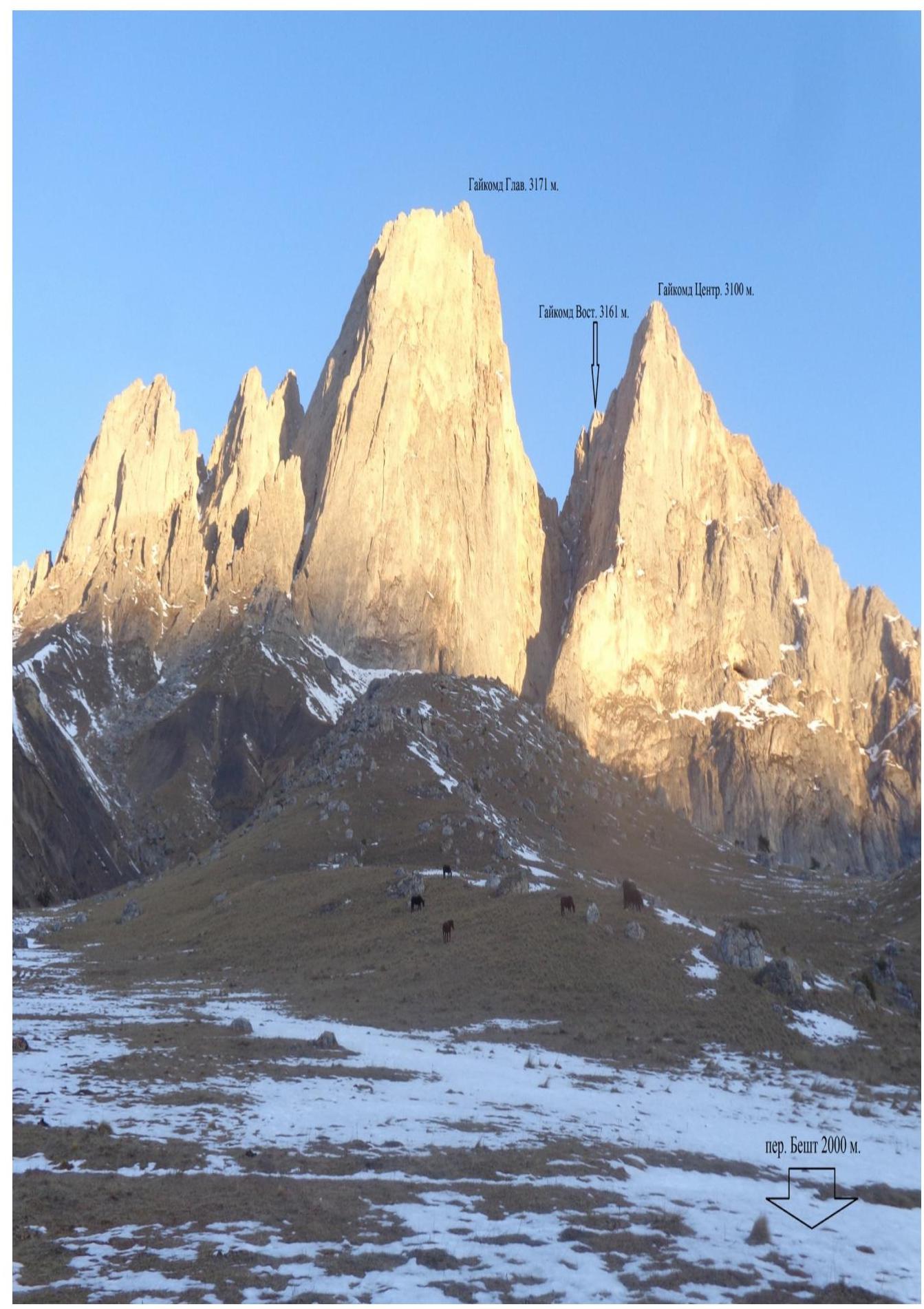
Overview of the ascent area
The Gaikomd peak massif is located in the Skalisty Range of the Greater Caucasus, between the Terek River (to the west) and the Assa River (to the east).
Gaikomd Central is the third highest peak in the massif, уступая по высоте Главной и Восточной вершинам. Previously, the peak was known as "Girech" in the classifier.
The administrative border between the Republics of Ingushetia and North Ossetia-Alania runs along the ridge to the Gaikomd peak from the west, and then continues north.
The ascent route and approaches are located on the territory of the Dzheyrakhsky district of the Republic of Ingushetia.
It is convenient to set up a base camp near the Besht pass, 100 m before the turn to the "Besht" border post, on a clearing 100 m from the road on the slope to the left. There is water available here year-round.
No border permits are required to access the Gaikomd peaks, but it is necessary to inform the border post of your presence in the area.
Only Beeline cellular network has a stable signal. The weather in the area is generally stable, and snow on the routes melts quickly. In winter, after heavy snowfalls, be cautious in couloirs and on windward slopes due to potential avalanches.
The approach to the route takes about 1 hour. Move in the direction of the southern walls of Gaikomd Main along the grassy ridge, and when 300 m from the wall, turn right and approach the start of the couloir between Gaikomd Main and Gaikomd Central. This is the starting point of the route.
The route is relatively monolithic, and despite the presence of snow on the ledges, it is generally dry. There are practically no loose rocks on the route. The terrain is diverse:
- narrow cracks where only anchor pitons should be used for insurance;
- large cracks suitable for large-sized "camalots";
- frequent occurrence of "rakoviny" (rock cavities) and "pesochnye chasy" (sand hourglass-shaped formations). There are no issues with setting up and reliability of insurance points throughout the route.
Descent is via the ascent route. The upper third of the route is characterized by varied terrain, unlike the lower third, which features "barani lby" (sheep's foreheads). This should be considered when planning the descent via the ascent route.
50 m from the start of the route, a rappel station was found, likely over 10 years old; no other signs of previous ascents were found along the route. A note from 1989 was found on the summit, indicating a first ascent that year via a 5A category route on Gaikomd Central, but the route's location was not specified.
The first ascent was made with the support of the North Caucasus Regional Rescue Team and the North Ossetian Rescue Team, which organized an observation group and assisted with cargo delivery to the base camp and under the route.
The team dedicated the ascent to the 25th anniversary of the EMERCOM of Russia.
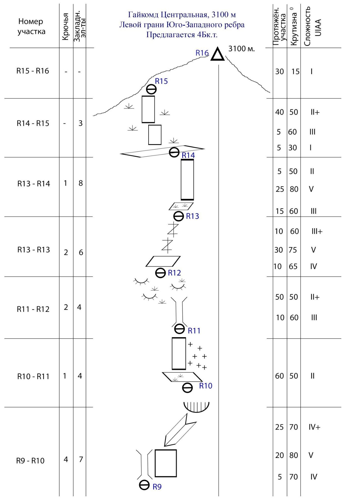
| :--: | :--: | :--: | :--: | | 25 | 80 | V | | 15 | 60 | III | | 10 | 60 | III+ | | 30 | 75 | V | | 10 | 65 | IV | | 50 | 50 | II+ | | 10 | 60 | III |
| Section # | Pitons | ||
|---|---|---|---|
| R8–R9 | 2 | 6 | |
| R7–R8 | - | 7 | |
| R6–R7 | 1 | 4 | |
| R5–R6 | - | - | |
| R4–R5 | |||
| R3–R4 | 2 | 1 | |
| R2–R3 | 2 | 3 | |
| R1–R2 | - | - |
 Gaikomd
(C) 3100
m
Gaikomd
(C) 3100
m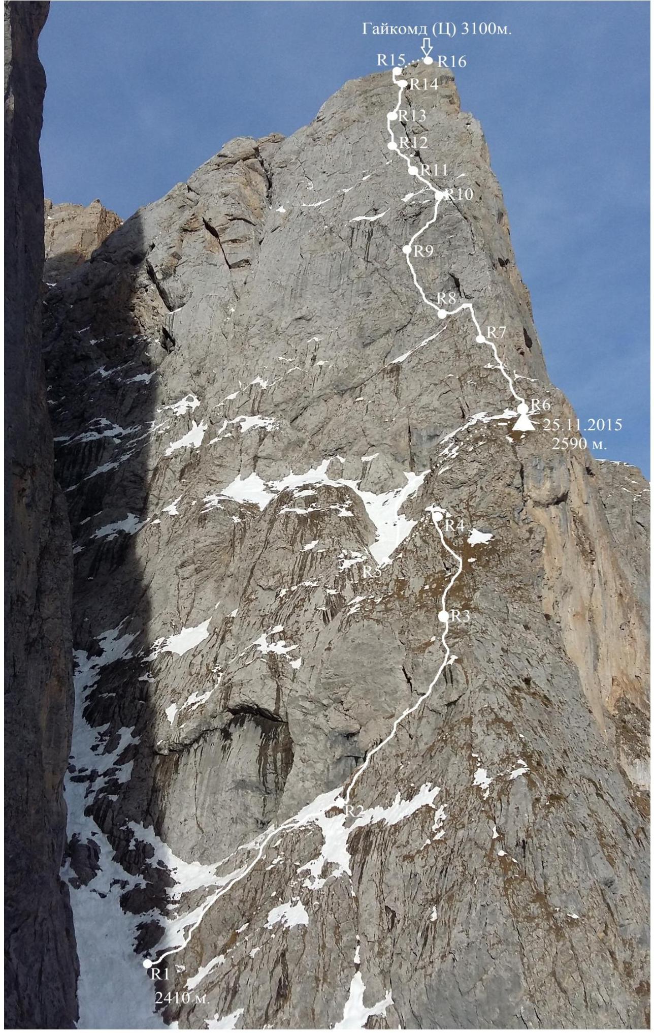 Route Description
- R1–R2: From the couloir between Gaikomd (Main) and Gaikomd (Central), move right and up via simple "barani lby" (sheep's foreheads) to the right of a detached rock lens, and then up the couloir to a нависающий камин (overhanging chimney).
- R2–R3: Move right and up via a grassy crack. Smooth rocks, careful climbing, first without a backpack. Exit onto a simple, grassy slope.
- R3–R4: Via simple rocks, move left and up to a steep ascent to the edge's inflection.
- R4–R5: Дюльфер (rappel) into a wide, snowy couloir.
- R5–R6: Up the snow-filled couloir, under the wall, and then right along the wall to exit onto the Southwest ridge. 2590 m — a suitable bivouac site.
- R6–R7: Up simple rocks to the start of a chimney that goes left behind the wall's inflection.
- R7–R8: Up the chimney, exiting via careful climbing on the smooth right part of the chimney. Exit onto a наклонная полка (inclined ledge) overgrown with grass; from it, 10 m left and down.
- R8–R9: Left and up via slabs and inclined ledges to the wall, and up it to the start of a wide chimney. Start of the key section.
- R9–R10: 2 m up the chimney, then transition right onto a steep rock section and up it for 20 m. Sparse relief, insurance via anchor pitons — key section of the route. Move towards an internally angled section развернутого вправо (unfolded to the right) and up through a small карниз (ledge) — exit onto an inclined ledge.
- R10–R11: From the ledge, left and up via a small couloir and simple rocks on its right side, towards a narrow chimney.
- R11–R12: Through the chimney, traverse left towards the start of a narrow, grassy crack.
- R12–R13: Up the crack directly to exit onto an inclined slab. Monolithic terrain with frequent "rakoviny" (rock cavities) and "pesochnye chasy" (sand hourglass-shaped formations).
- R13–R14: Up the slab to the right — exit onto the wall left of a wide chimney. 20 m of challenging climbing and exit onto a "balcony".
- R14–R15: Into the left angle of the balcony and up — exit onto simple terrain overgrown with grass, leading to the pre-summit ridge.
- R15–R16: Along the simple ridge — exit onto the summit.
The route is logical, rich in terrain features, and relatively monolithic. In the off-season and winter, snow does not linger on the route, contributing to a moderately safe avalanche situation. For organizing insurance points, medium-sized "camalots" and закладные элементы (placed elements) work well; the presence of anchor pitons in the group will accelerate and secure the progression.
The route corresponds to the specified category of difficulty and is similar in climbing level to classified routes of the same category:
- S. Egorin's route on Monakh peak,
- V. Kuznetsov's route on Stal' peak,
- more challenging than I. Galustov's route on Belalakaya peak.