| 1. Climbing category | — rock climbing |
|---|---|
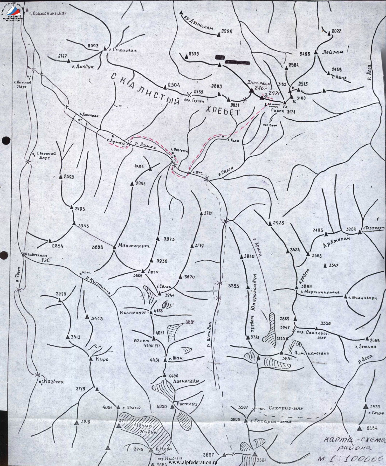
| 2. Climbing area | — East Caucasus, Scaly Ridge, watershed of Armhi and Assa rivers, Chechen-Ingush ASSR. |
| 3. Summit, its height, climbing route | — Girech Zapadnaya (2971 m) via the left couloir of the S wall and the SE ridge. |
| 4. Route characteristics | |
| a/ height difference on the route | — 720 m. |
| b/ route length | — 2865 m. |
| c/ average steepness of the route | — 42° |
| 5. Pitons used for belaying (for creating ITO): | |
| rock pitons | — 7 pcs. |
| chock stones | — 2 pcs. |
| ice screws | — 1 pc. |
| 6. Time spent on the route: | |
| to the summit | 9–10 hrs. |
| 7. Number of bivouacs and their characteristics: | NONE |
| 8. Proposed difficulty category: | 2B |
| 9. Full name of team leaders, participants, and their qualification | |
| 1. Kravchenko S.Ya. | — 1st sports category |
| 2. Kurochkin A.G. | — Candidate Master of Sports. |
| 10. Team coach | — Kurochkin A.G. |
| 11. Date of departure on the route and return to base camp: | |
| a/ departure on the route | — October 5, 1984 |
| b/ reaching the summit | — October 5, 1984 |
| c/ return to camp | — October 5, 1984 |
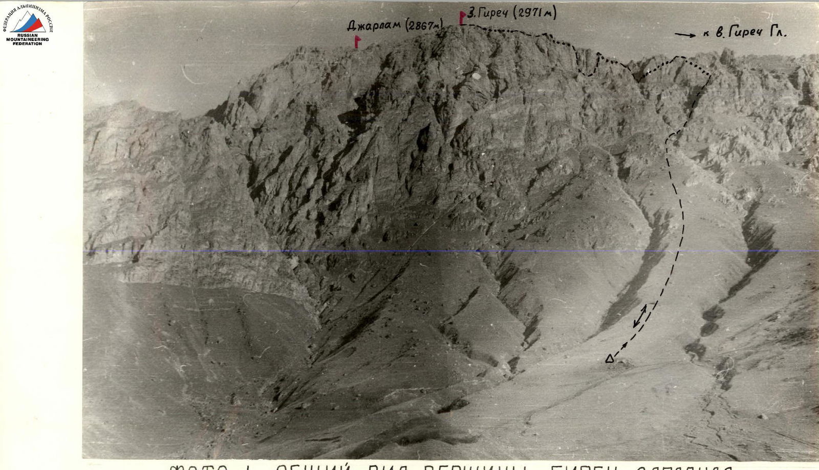 |
PHOTO 1. General view of Girech Zapadnaya summit
Description of the climbing route to Girech Zapadnaya summit (2971 m) via the left couloir of the S wall and the SE ridge (3A cat. diff.)
From the bivouac near the spring, ascend 25° grassy slope to the route in 1.5 hours. There are small ravines on the right and left.
Traverse 300 m to the right ravine to a clearly visible couloir on the right. Ascend 470 m through a narrow couloir with scree slope, steepness 25°–30°, to the first rock ascent ("live" stones) (rope up!).
Ascend 30 m through simple, destroyed rocks in the couloir, steepness 55°–60°, to a widening of the couloir.
Continue 260 m on a steep scree slope, possibly filled with deep snow (in winter), to a sheer wall. Bypass it on the left for 40 m and exit right to the slope through a narrow crevice. Ascend 320 m on a scree slope, possibly snow-covered, to high rock spires on the ridge.
In the middle of the slope, under the spires (landmark), there is a huge boulder, 12–15 m in diameter.
From it, traverse 60 m left and upwards, 30°–35°, to a narrow (5–7 m) scree-filled 45°, 120 m couloir, which leads to the ridge under a destroyed spire. Pass it "head-on" through 40° 40 m rocks (alternating belays through outcrops) and along the left side of the ridge to a rock outcrop. Bypass the outcrop on a 15°–20°, 70 m slope, then descend 20 m into a 55° couloir, 10–12 m wide. Then move right into a narrow (2–3 m) 65°–70°, 15 m couloir ("live" stones) onto a narrow ridge connecting ridge. On the left, there is a large "tower" 25–30 m high.
From the connecting ridge, bypass the "tower" on the right for 70 m, exiting onto the north shoulder of the "tower" (smooth rocks, ice!). From the shoulder, along the walls (pitons for belaying) ascend 40 m on a 60°–65° slope to the ridge near a spire resembling a "tooth" (7–8 m) (snow, ice).
Bypass the "tooth" spire on the left for 30 m. Then descend 40 m through a 30°–35° couloir with small scree and ascend right through destroyed rocks to the walls of the second "tower".
From the wall, descend 60 m on a grassy slope to a narrow 20–25 m, 65°–70° couloir onto the ridge. On the right side, ascend 75°–80°, 50 m on steep rocks to a ledge. From the ledge, ascend 75°–80°, 30 m to the ridge crest. On the sharp ridge, move 15 m to a spire hanging south. Bypass it on the right through a traverse on an 80° inclined slab (pitons for belaying). Then move 40 m on a sharp, partially destroyed ridge ("live" stones). Bypass the spires along the walls, 80°, 35 m on very narrow, smooth ledges, and exit to the ridge under a tower wall. Ascend 20 m on a 70° inner corner to a "Flat tower" terrace.
From here, ascend along a heavily destroyed ridge to the summit wall (10–12 m, 80°–85°) of Girech Zapadnaya.
Cross to the opposite side of the ridge on the left through scree ledges and simple, destroyed 35°–45° rocks — 45 m, to reach the summit of Girech Zapadnaya. From the "Flat tower", it's 120 m.
From the bivouac to the summit: 9–10 hrs. Descent via the ascent route: 5–6 hrs.
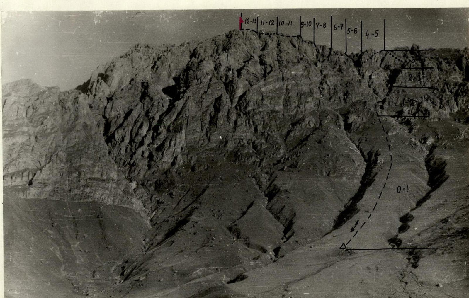
PHOTO 2. General view of Girech Zapadnaya summit 2971 m with sections of the 2B cat. diff. route

Route breakdown by sections
| Section | Avg. steepness, ° | Length, m | Terrain characteristics | Cat. diff. | Condition | Weather conditions | Rock pitons | Chock stones | Ice screws |
|---|---|---|---|---|---|---|---|---|---|
| R0–R1 | 25 | 800 | Grassy slope | 1 | good | simultaneous | |||
| R1–R2 | 25–30 | 470 | Couloir, scree slopes, couloir | 1 | small scree, medium-sized stones | simultaneous | |||
| R2–R3 | 55–60 | 30 | Simple rocks | 2 | destroyed rocks | outcrops | |||
| 30 | 260 | Couloir | small scree | ||||||
| R3–R4 | 40 | 40 | Rock crevice | 1 | slope with small scree turning into rocks | ||||
| 25 | 320 | Scree slope | 1 | medium scree, snow | simultaneous | ||||
| R4–R5 | 30 | 80 | Scree slope | 1 | small and medium scree | simultaneous | |||
| 45 | 120 | Couloir | 1 | couloir with small scree | |||||
| 40 | 40 | Destroyed spire | 2 | destroyed rocks, snow, ice | outcrops | ||||
| R5–R6 | 15 | 70 | Ledges | 1 | wide ledges with small scree | simultaneous | |||
| 50 | 20 | Couloir | 2 | small and medium scree, snow, "live" stones | outcrops | ||||
| 70 | 15 | Couloir | |||||||
| R6–R7 | 45 | 70 | Steep slope "Sheepbacks" | 2 | slope covered with ice under snow | 1/0 | 0/0 | 1/0 | |
| 60 | 40 | Ledges | 2 | snow-covered ledges, ice | 1/0 | ||||
| R7–R8 | 30 | 40 | Couloir | 1 | Small scree | simultaneous | |||
| 60 | 30 | Simple rocks | 2 | destroyed rocks | outcrops | ||||
| R8–R9 | 25 | 60 | Grassy slope | 1 | simultaneous | ||||
| 70 | 20 | Couloir | 2 | narrow couloir, "live" stones | outcrops | ||||
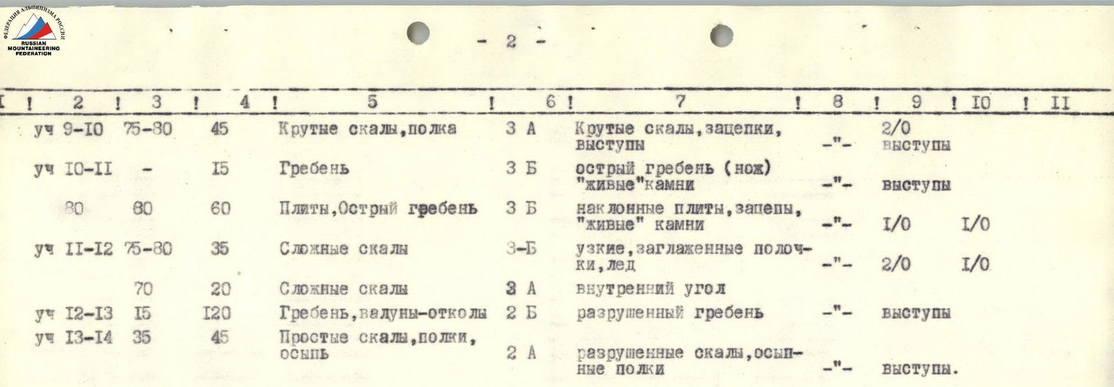
| R9–R10 | 75–80 | 45 | Steep rocks, ledge | 3 | steep rocks, holds, outcrops | 2/0 | outcrops | ||
| R10–R11 | – | 15 | Ridge | 3 | sharp ridge (knife-edge) "live" stones | outcrops | |||
| 80 | 60 | Slabs, sharp ridge | 3 | inclined slabs, holds, "live" stones | 1/0 | 1/0 | |||
| R11–R12 | 75–80 | 35 | Complex rocks | 3 | narrow, smooth ledges, ice | 2/0 | 1/0 | ||
| 70 | 20 | Complex rocks | 3 | inner corner | |||||
| R12–R13 | 15 | 120 | Ridge, boulders | 2 | destroyed ridge | outcrops | |||
| R13–R14 | 35 | 45 | Simple rocks, ledges, scree | 2 | destroyed rocks, scree ledges | outcrops. | |||
 |
Total time to the summit — 9–10 hrs.
Descent via the ascent route — 5–6 hrs.