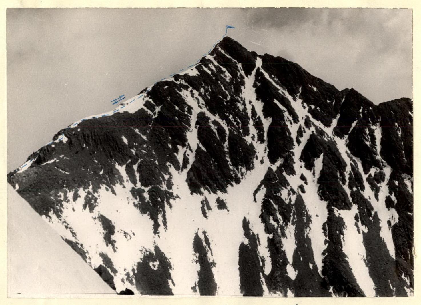
North Kaidzhany from the East
PD - PD+ cat. diff.
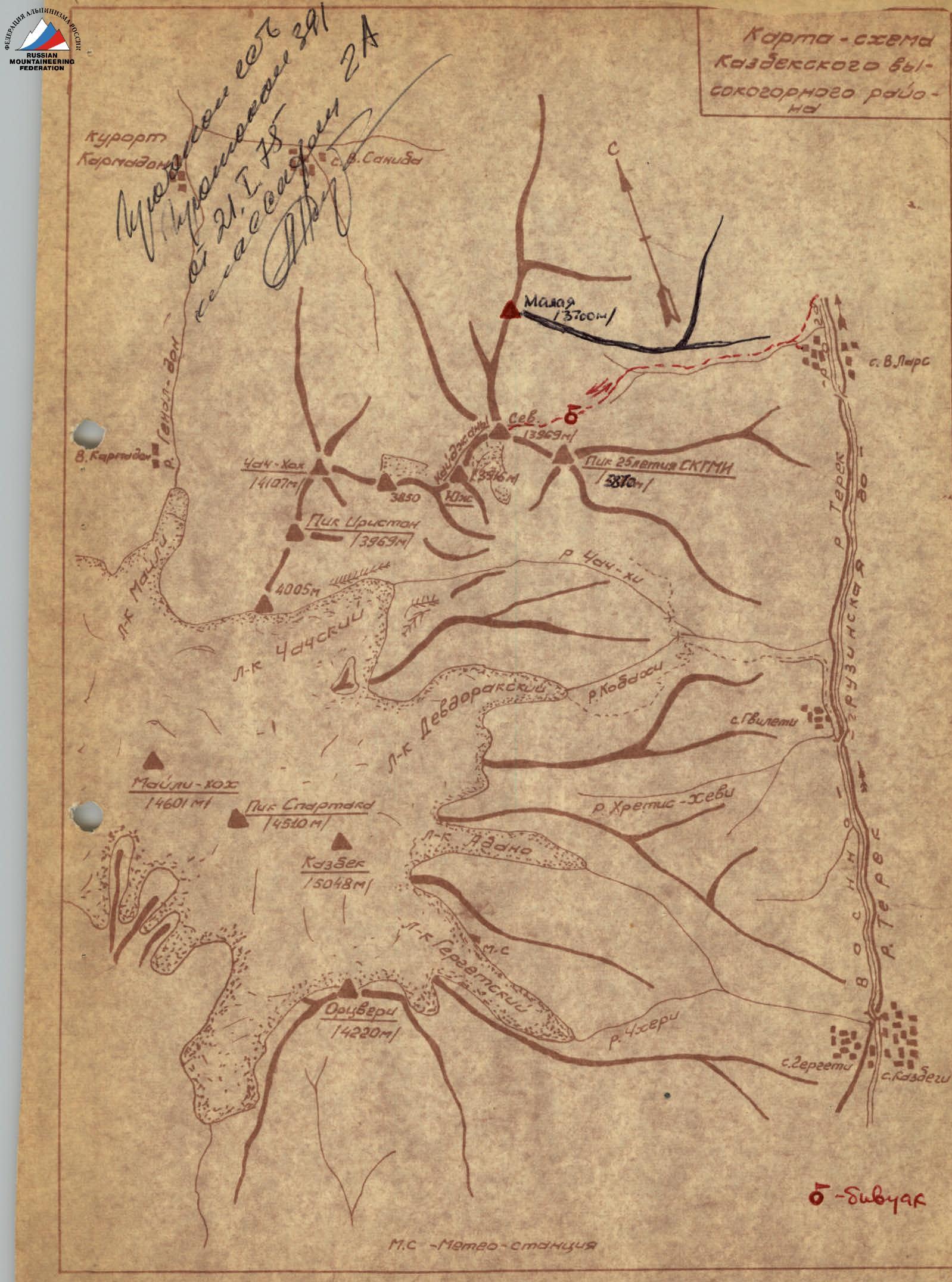
The Kaidzhany massif is part of the Kazbek group of peaks in the Central Caucasus. North Kaidzhany is located in the northern spur of Peak Spartak. The summit is a nodal point. The northern ridge leads to Malaia Kaidzhany (3700 m), the southwestern ridge leads to South Kaidzhany (3916 m), and the southeastern ridge leads to Peak 25th anniversary of SKGMI (3870 m).
The following routes are laid on North Kaidzhany:
- From the South from Chachskoye gorge — 1B cat. diff.
- Along the Northern ridge with exit from the gorge of the Belaya River. — PD cat. diff.
The route along the Eastern edge from the Belaya River gorge was first climbed on August 5, 1973, by a group of climbers from Ordzhonikidze led by R. P. Proskuryakov. The ascent with return to Ordzhonikidze takes 1.5 days.
Terrain
Drive along the Military Georgian Road to the village of Verkhniy Lars (1200 m above sea level). To the right, before the village, the Belaya River flows into the Terek River.
Walk along the trail along the left bank for about 3 hours to the area of the trough-shaped expansion of the gorge.
Cross the stream in the area of the scree and move up along the steep right slope of the trough.
After 1.5–2 hours of walking, it is advisable to set up a bivouac on an old scree, where there are two platforms for tents (2300 m above sea level).
It is recommended to start early. After 1.5 hours of moving along the wide scree in the direction of the pocket located between the rocks of the gorge side and the steep moraine bastion (azimuth 250°), enter the large trough east of North Kaidzhany.
Further:
- Move along the pocket, turning to the right.
- There is a risk of rockfall from the couloir on the left into the pocket.
- (Avalanche danger in winter!)
The landmark is the "funnel" (azimuth 290°).
Cross the trough along hilly snowfields (the average height of the trough is 3100 m above sea level) with a gradual gain in height.
A snow slope of medium steepness (avalanche danger in winter!) leads from the trough to the "funnel" for 300–400 m. To the right of the "Funnel" is a characteristic terrace-like moraine (3400 m above sea level), which is about 1 hour's walk from the trough. A scree slope of 300–450 m with a steepness leads along the terrace to the upper depression on the rocky Eastern slope of the summit (3450 m above sea level).
Further, in rope teams, climb along simple, heavily destroyed shale rocks of the counterfort, complicating the Southeastern spur of the Eastern edge of the summit, to the junction of the spur with the Eastern edge at a height of 3800 m above sea level.
The Eastern edge of the summit rises from here with three ascents-walls. Its average steepness is 40°. The height difference to the summit is 150 m. Insurance with alternate movement through rocky outcrops. Many "live" stones! The ascent time from the trough to the summit is about 3 hours.
The descent along the ascent route takes up to 2 hours to the bivouac, from where it is another 2 hours down to the Military Georgian Road.
Equipment recommended for a group of 4 people:
- [list not created, as the number of elements is not specified][list not created, as the number of elements is not specified]
Main rope 30 m — 2 ends, rock hammer — 1 pc., rock pitons — 5 pcs.
Description compiled by:
 Master of Sports of the USSR R. P. Proskuryakov.
Photo by R. P. Proskuryakov.

North Kaidzhany. Route from the East. View from the North-East.
North Kaidzhany. View from the South. Photo by R. Proskuryakov.