Ascent Passport
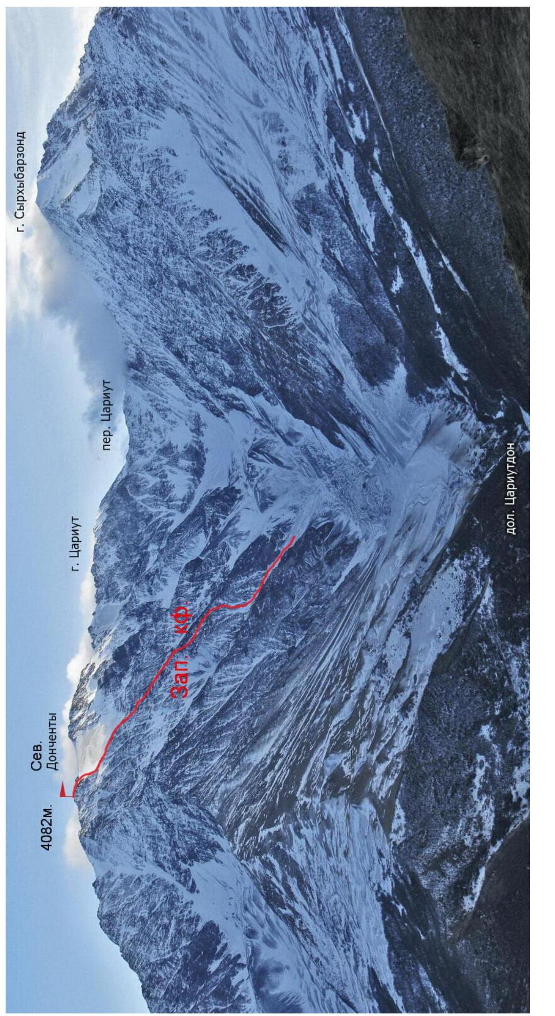
- Caucasus. Lateral Ridge, Tsariutdon gorge, section number in KMGV 2.8.
- Donchenty North (4082 m) via the Western counterfort.
- 2A category of difficulty, first ascent.
- Route character — rocky.
- Route height difference — 900 m.
Total route length — about 1800 m. Average route steepness — 30°.
-
Pitons driven:
rocky — 6, ice — 2, placements — 2.
-
Travel hours — 12; days — 1.
-
Overnight stay below the route, in the Tsariutdon gorge.
-
Leader: Egorin Sergey Vladimirovich — CMS.
Participants: Ivanov Vitaly Valentinovich — CMS.
-
Coach: Korablin Boris Nikolaevich, MS, Honored Coach of the RSFSR.
-
Route entry: November 6, 1995.
Summit ascent: November 6, 1995. Return to B.L.: November 6, 1995.
-
Organization: North Ossetian Republican Search and Rescue Service of the EMERCOM of Russia.
Brief Overview of the Ascent Area
The first ascent area is located in the North-Eastern Caucasus, in the Syrkh-Barzond — Tsarnut — Donchenty massif. This massif is situated in the northern spur of the Lateral Ridge. The route to the Donchenty summit begins in the Tsariutdon river gorge, which is a right tributary of the Fiagdon river.
In the upper reaches of the gorge is a steeply descending northward Tsariut glacier. This glacier is bounded by the surrounding peaks in a horseshoe-shaped ridge:
- Syrkh-Barzond
- Medik
- Tsarnut
- Khirkhaten
- p. Pirogov
- Donchenty
In the northern ridge of Donchenty, beyond the Liko Donchenty pass (3900 m, 2B) lies the Donchenty North summit (4082 m). It is clearly pronounced and bounded on both sides by saddles.
Existing classified routes to the above-mentioned peaks start from two adjacent gorges of the Fiagdon and Midagrabindon rivers. The Tsariutdon gorge used to be visited only by tourist groups that traversed three passes in its upper reaches.
The rocks in the Tsariut gorge are mainly sedimentary in origin, most often clay shales. Therefore, all the ribs and counterforts descending into the gorge are dissected by numerous shelves and couloirs.
Between the counterforts are ice-snow slopes, mostly steep. Potential ice-snow routes of 3–4 category of difficulty are possible along them.
The climate in the area is typical for the Caucasus, with a maximum of precipitation in summer.
Description of the Approach to the Route
From Vladikavkaz city, take a bus going to Kharisdzhin village to get to Khidikus village (about 1.5–2 hours).
Passing through the village, follow a dirt road to the Tsariutdon river. Then follow the right (in the direction of travel) bank of the river to a kosh (half an hour).
Continue along the trail along the river, without crossing it anywhere else.
Moving through the forest and exiting it, continue to ascend along old overgrown moraine. Here the river disappears, and the gorge widens (1.5 hours from kosh).
Approach a sharp scree ridge along the moraine and begin ascending towards a steep grassy-scree ascent. Continue ascending through the ascent, which is bounded on the left by rocky walls (2 hours from the beginning of the moraine).
Overnight stay is possible here.
After the walls on the left end, ascend left — up a snow-scree slope. This slope is bounded on the right by the Western counterfort of the visible Donchenty North summit ahead — above (another half hour). Continue along the snow-scree slope towards the Western counterfort — 1 hour. The elevation here is 3100 m.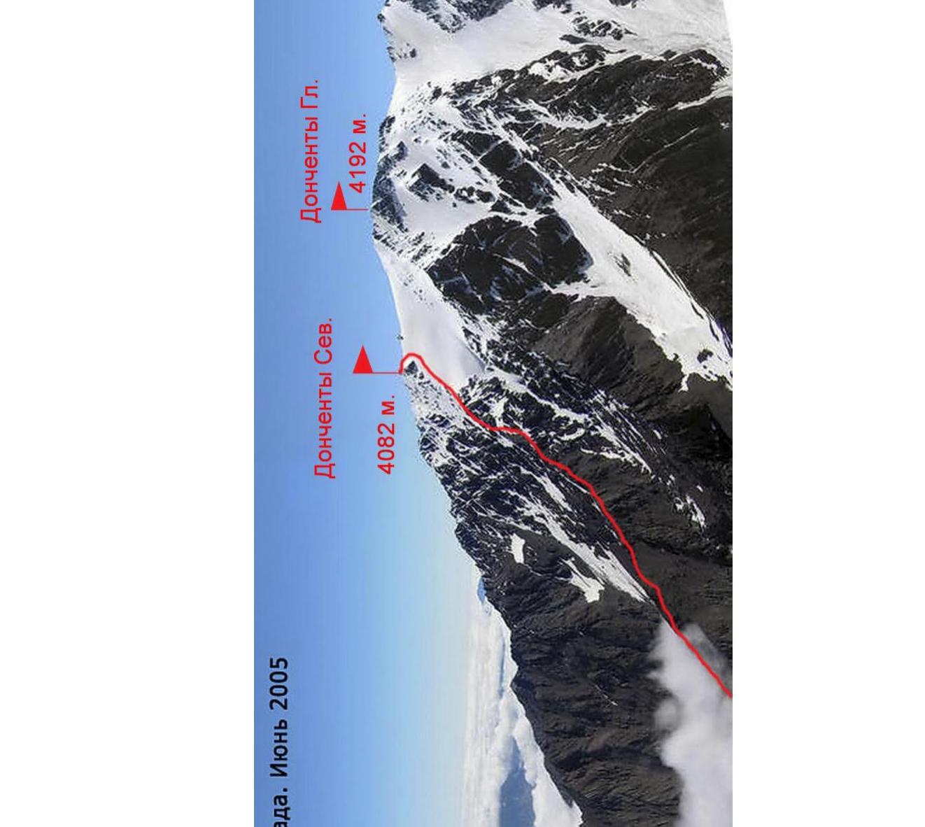
Donchenta from the west. June 2005.
Route Description
Section R0–R1: Approach the Western counterfort (be cautious of avalanches during the off-season!), ascend via couloirs or any of the small ribs descending from the Western counterfort to the North — North-West.
Section R1–R2: The ascent path is category 2–3, 20–30°, about half an hour to reach the counterfort.
Section R2–R3: Continue moving along the Western counterfort towards the Donchenty North summit. Along the rocks, category 2, occasionally 3; bypassing complex sections via shelves, mostly to the right, approach the key wall.
Section R3–R4: Overcome the wall head-on, starting along a vaguely defined inner corner. Piton belay — possible use of placements. Above the wall is a shelf, where "live rocks" are present!
- Wall height — 5 m
- Angle of inclination — 70°
- Category of difficulty — 4
To this point, it takes 2–2.5 hours from reaching the counterfort.
Section R4–R5: Continue along the rocks, category 2B, 3B, occasionally scree Western counterfort, move towards the steep glacier descending westward from the northern ridge of the Donchenty summit. Bypass the glacier tongue to the left along scree shelves and rocks, category 1B, 2B, and then exit the counterfort to the right onto the glacier.
Section R5–R6: Ascend directly up the glacier, 25–35°. Then, bypassing the summit tower to the right along the glacier, category 3B, 3B+. Upon reaching the main ridge, we find ourselves to the right of the summit.
Section R6–R7: Along the ridge to the left, 100–150 m, along rocks, category 2–3, 15–30°, we reach the Donchenty North summit.
It takes another 2 hours from the key wall. To the east are visible:
- Shau-khokh
- Jimarai-khokh
To the west — the Arkhon-Tepli massif and the Tsey district. No signs of human presence were found on the summit.
Descent via the ascent route takes 4–5 hours.