Report
on the first ascent to the summit of Barzuikhox, from the South, 1B category of complexity, by a joint team of AK "Kaskad" and KAT "Fatum" on August 30, 2023
I. Ascent Passport
| № | 1. General Information | |
|---|---|---|
| 1.1 | Full name, sports rank of the leader | Egorin S.V. – Master of Sports |
| 1.2 | Full name, sports rank of participants | Artyukhovskaya E.N. – badge holder Dzarakhohov A.S. – badge holder Ketoev K.E. – badge holder Tolistikova E.Yu. – 2nd sports rank Khetagurov S.S. – badge holder Tsabolov I.R. – badge holder |
| 1.3 | Full name of coach | Egorin S.V. |
| 1.4 | Organization | FSR of Alania: AK "Kaskad" and KAT "Fatum". |
| 2. Characteristics of the Ascent Object | ||
| 2.1 | Region | Caucasus, Rock Ridge |
| 2.2 | Gorge, massif | Kion massif |
| 2.3 | Section number according to the 2020 classification table | 2.7 |
| 2.4 | Name and height of the summit | Barzuikhox 3381 m |
| 3. Characteristics of the Route | ||
| 3.1 | Route name | from the South |
| 3.2 | Proposed category of complexity | 1B |
| 3.3 | Degree of route development | First ascent |
| 3.4 | Nature of the route relief | Rocky |
| 3.5 | Height difference of the route | 400 m |
| 3.6 | Route length | 550 m |
| 3.7 | Technical elements of the route | I category of complexity ice/rock/combination – 200 m. II category of complexity ice/rock/combination – 200 m. III category of complexity ice/rock/combination – 30 m. IV category of complexity ice/rock/combination – 20 m. Movement on closed glacier – none. Rappelling – on section R2–R1. |
| 3.8 | Descent from the summit | Via the ascent route. |
| 3.9 | Additional information on the route | Mobile phone coverage on the route – Megafon. |
| 4. Characteristics of the Team's Actions | ||
| 4.1 | Time of movement | 5 hours of walking time |
| 4.2 | Overnight stays | none |
| 4.3 | Exit to the route: from R0 | 7:00, August 30, 2023 |
| 4.4 | Reach the summit | 12:00, August 30, 2023 |
| 4.5 | Descent to the road | 17:00, August 30, 2023 |
| 5. Responsible for the report | ||
| 5.1 | Full name, e-mail | Egorin S.V., e.s.128@mail.ru |
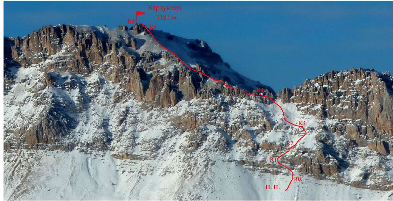
Photo 1.
1.1. General photo of the summit of Barzuikhox. February 2011. Photo from a helicopter. View from the South. The route of the first ascent is marked in red.
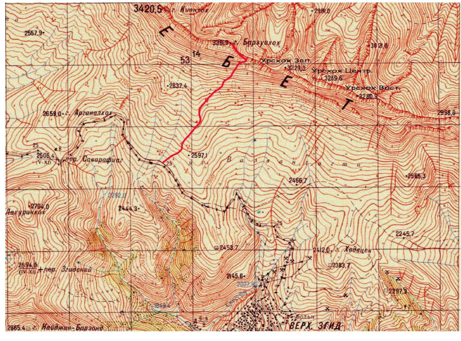
Photo 2. 1.2. Map of the ascent area. Scale 1:50 000.

Photo 3. Map of the ascent area compiled by G. Mertsbakher at the end of the 19th century. It is interesting to note the presence of significant glaciation 150 years ago on the Kion massif.
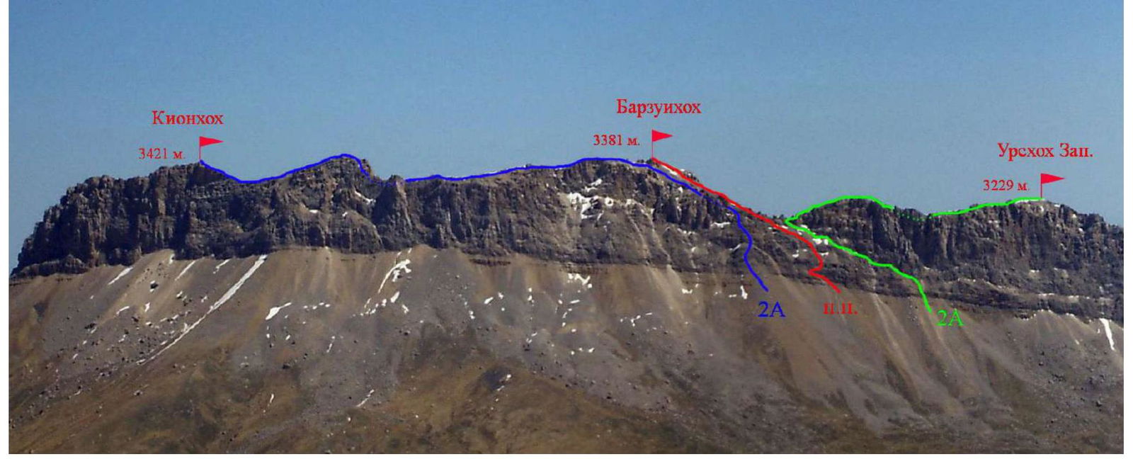
Photo 4. 1.3. Photopanorama of the area. May 2006. View from the South, from the summit of Sadonhokh.
The route of the first ascent and previously climbed routes are marked.
2.3. Technical characteristics of the route sections.
| Section № | Relief characteristics | Category of complexity | Length, m | Type and number of anchors |
|---|---|---|---|---|
| R0–R1 | Rocky-scree slope | 1–2 | 60 m | Belay through ledges |
| R1–R2 | Rocky belt with short ledges | 2–4 | 50 m | 2 anchors, 3 chocks |
| R2–R3 | Scree slope ending in a wall. | 1–3 | 70 m | Belay through ledges |
| R3–R4 | Rocky-scree slope | 1–2 | 150 m | Belay through ledges |
| R4–R5 | Rocky-scree ridge | 1–2 | 200 m | Belay through ledges |
| R5–R6 | Rocky ridge | 1–3 | 20 m |
3.1.1 Description of approaches to the route, history of summit development.
From Vladikavkaz to the village of Verkhny Zgid, it takes 1.5–2 hours by car. The village is bypassed from below and from the east via a dirt road. Before reaching the Zgid pass leading to Digoria, near the entrance to the selective potato fields, we start moving on foot, straight up, to the North. Coordinates of the starting point: 42.891819° N, 43.959307° E, elevation 2450 m.
After reaching the fields, we move along the left edge of the westernmost field. After it ends, we start climbing left – up, onto a wide grassy ridge – slope. From here, the exits to the ridge of the Kion massif are visible, through scree terraces with rocky belts.
The most convenient route to the ridge was to the right, it is marked in green on the panorama of the area. However, part of this terrace collapsed. The collapse occurred in the summer of 2022, and its passage is now unsafe – since the rocks above the terrace continue to collapse, and the slope under this area is unstable.
The leftmost option (and the most difficult) was taken in fog, in snowfall conditions in April 1996, during the first ascent of the route to Kionkhokh – it is marked in blue. The route of the first ascent, taken by our team in 2023, is currently the most logical and safe path to the ridge of the Rock Ridge in this area of the Kion massif.
The summit of Barzuikhox is interesting as a standalone tower for climbing to the highest point of the ridge in this area. The summit of Barzuikhox is marked on "kilometer" maps and on 1:50,000 scale maps.
Interestingly, on Mertsbakher's map from the end of the 19th century (provided in the report), the summit is called "Barzui Avdur khokh", which can be translated from Ossetian as "Ridge of Seven Stones". There are many standalone rocky outliers on the saddle of the ridge in this area. Apparently, the second word was dropped when transferring to modern maps.
Previously, the tower of Barzuikhox was not climbed, since the route to Kionkhokh passes below it. In 2018, an EMERCOM team, having climbed the summit, found a note from Proskuryakov R.P. and Lunev B.G., who wrote that they had climbed Kionkhokh. Subsequently, I learned from them that they had climbed in fog and thought they had reached the highest point of the Kion massif. However, they did not climb the highest rock on the tower.
Having passed the grassy ridge – slope, we approach individual boulders from the 2022 collapse, and then exit onto a scree slope. The ascent path goes up, towards the leftmost light scree, formed by fallen rocks from above. From here, the entry to the route along the lower ledges is visible. Coordinates of the start of the route: 42.906209° N, 43.957221° E.
3.1. Brief description of the route passage.
| Section № | Description | Photo № |
|---|---|---|
| R0–R1 | Approaching the southern walls of the massif, we start moving left and up, along scree ledges under the rocks with black streaks. Section 60 m, 1–2. Caution – loose rocks on the ledges! | |
| R1–R2 | Further, we move along the right part of the black rocks. First, along an internal corner, then we move right and up along a ledge, almost to the end. Then up through a narrow rocky belt, exiting onto another ledge, we move along it to the left, under an 8 m wall. Above it, there is a ledge for securing the rope. The entire section is 50 m, 2–4, up to 80°. | 5,6 |
| R2–R3 | After the rocks, we move along a scree slope to the right and up, under a small rocky belt. We pass it along a wide internal corner, 40–50°, 2–3. The entire section is about 70 m. | |
| R3–R4 | Above the rocks, we exit onto an old trail, visible in places on the scree slope. The further path moves left and up, towards a triangular rock on the ridge. By passing it on the left, we exit onto the Southeast ridge of the summit of Barzuikhox. The entire section is 150 m, 1–2, 20–30°. | |
| R4–R5 | Along the scree ridge – slope, we move West, bypassing rocky outliers on the left. We bypass the summit tower on the right and approach its base from the North. The entire section is about 200 m, 1–2. | 7 |
| R5–R6 | Along rocks 1–3, we climb 20 m to the summit cairn. The highest rock on the tower is located to the West. It is half a meter higher than the platform with the cairn. We climb there with gymnastic belay from the connecting ridge. Caution – rocks are fragile. At the top – space for one person. | 8,9 |
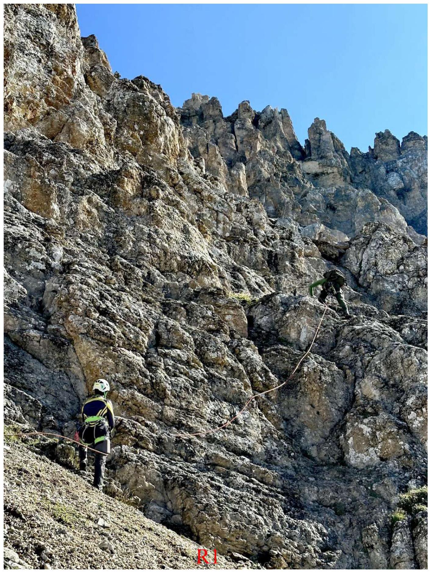
Photo 5. Beginning of section R1–R2. Climbing an internal corner.
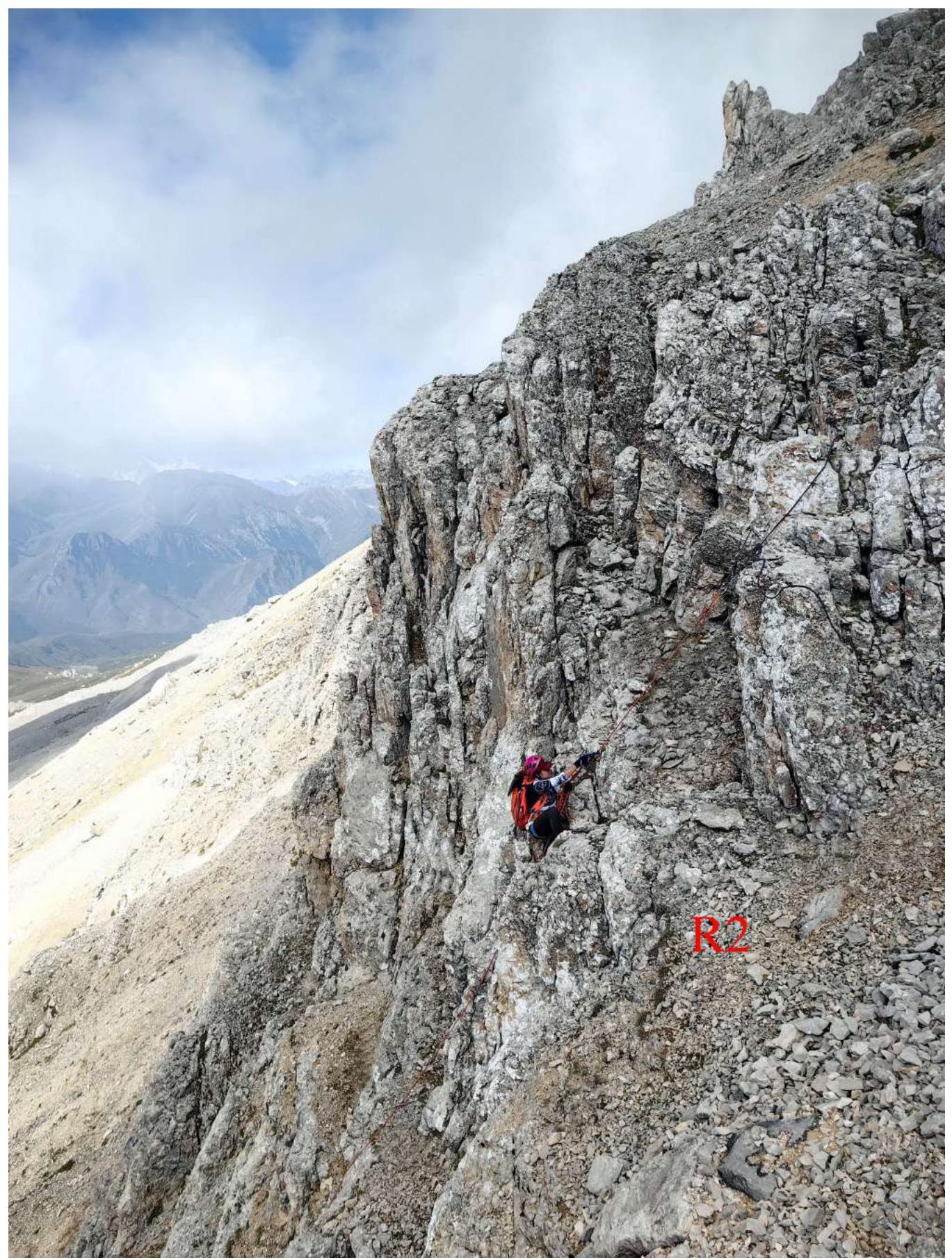
Photo 6. Passing the upper part of section R1–R2. Climbing with fixed ropes. The profile of the lower part of the route is visible.
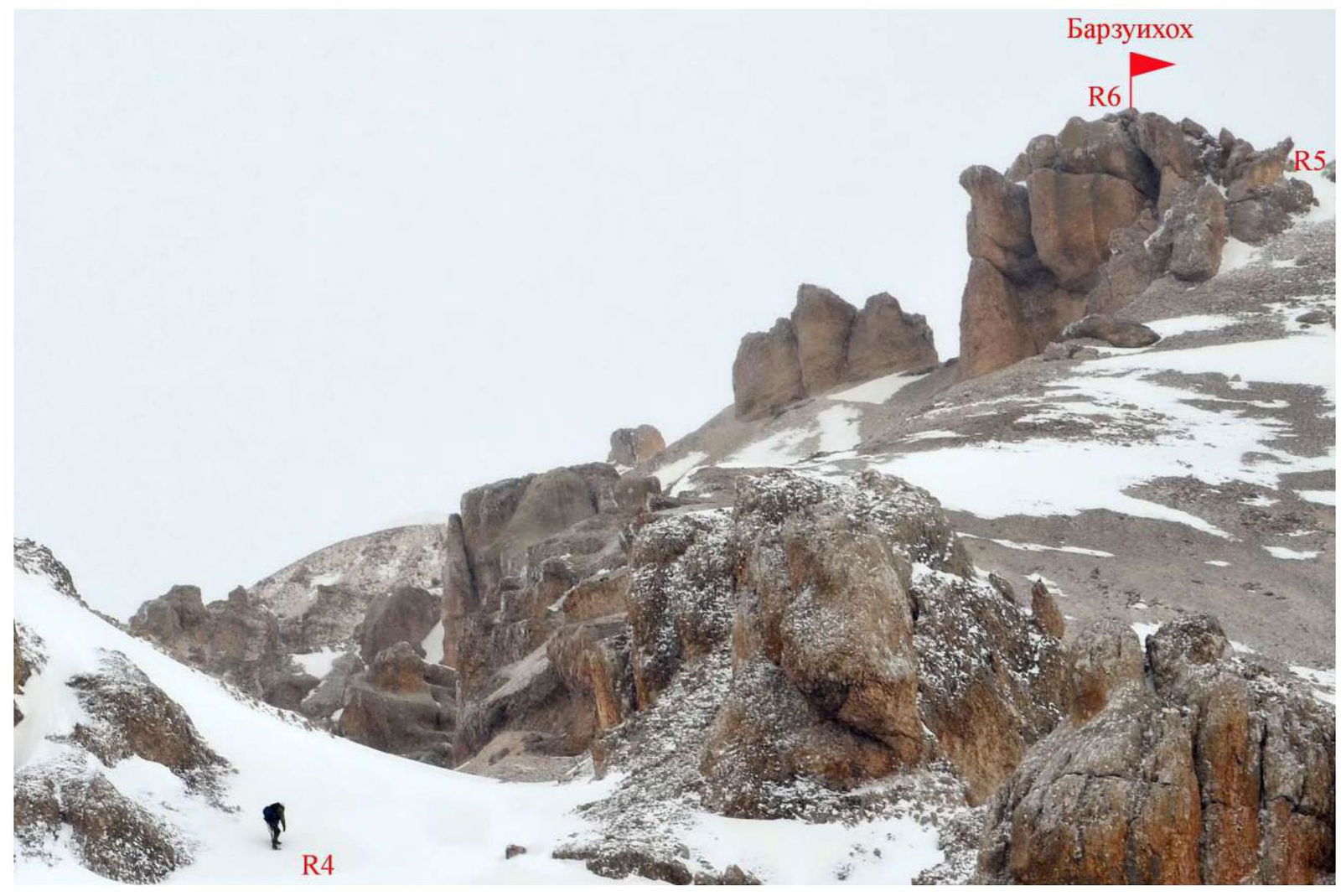
Photo 7. Passing section R4–R5. April.
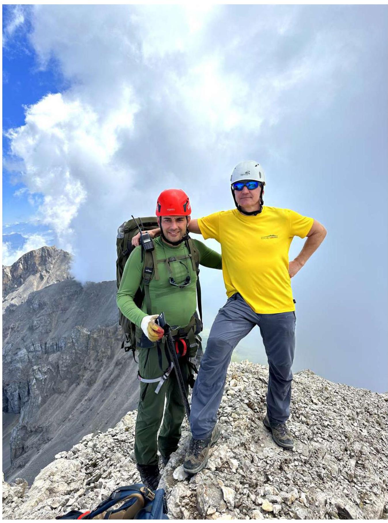
Photo 8. Egorin S.V. and Dzarakhohov A.S. near the summit cairn. View to the East.

Photo 9. 3.2. At the highest point of the summit of Barzuikhox – Tolistikova E.Yu.
3.3. Recommendations for the route.
Descent from the summit via the ascent route, with rappelling on section R2–R1. It is recommended to take 50 m long ropes.
The route taken on Barzuikhox:
- Is logical and safe.
- Corresponds to 1B category of complexity when moving along the route line.
- Is a good route for practicing the movement of training groups on rocks of initial categories.
The route taken is currently the easiest and safest path to the ridge of the Kion massif – in its Central part. It can also serve as a starting point for previously climbed routes of 2A category of complexity:
- Kionkhokh via the Eastern ridge,
- Urskhokh Western via the Western ridge.
For those visiting the ascent area for the first time, it is recommended to study the terrain in Google Earth beforehand.