Report
on the ascent to the summit of Khitsan-khokh via the buttress of the NW ridge, approximately category 4B difficulty of the team from the "Tsey" alpine camp 300, 745, M V 155, 300, 201 60°, 54 rock pitons, 55 chocks, 8 hours total time
Team leader V.A. Karabash
Team coach V.S. Neborak
"Tsey" Alpine Camp — 1984
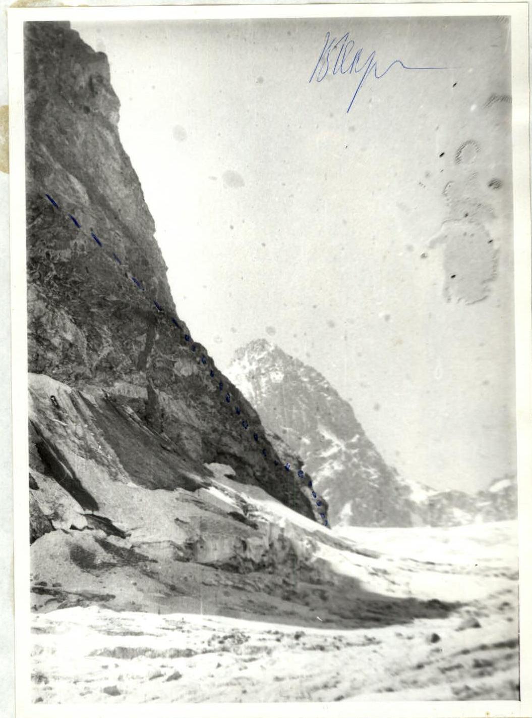
Photo 2. Profile of the buttress from the left. Lower part. Taken on August 5, 1984, from point #2, ~300 m, T-43, P = 40 mm
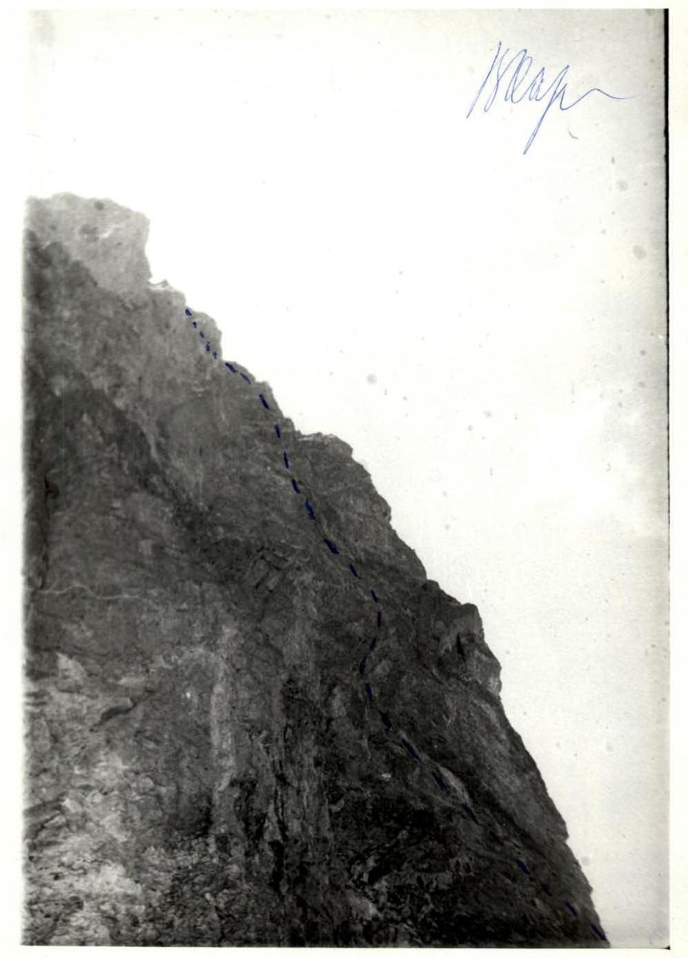
Photo 2a. Profile of the buttress from the left. Upper part. Taken on August 5, 1984, from point #2, ~300 m, T-43, P = 40 mm
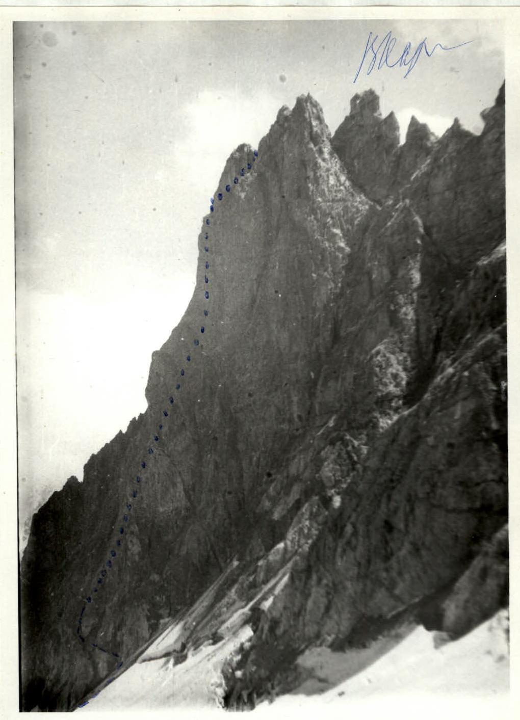
Photo 3. Profile of the buttress from the right. Taken on August 5, 1984, from point #3, ~500 m, T-43, P = 40 mm
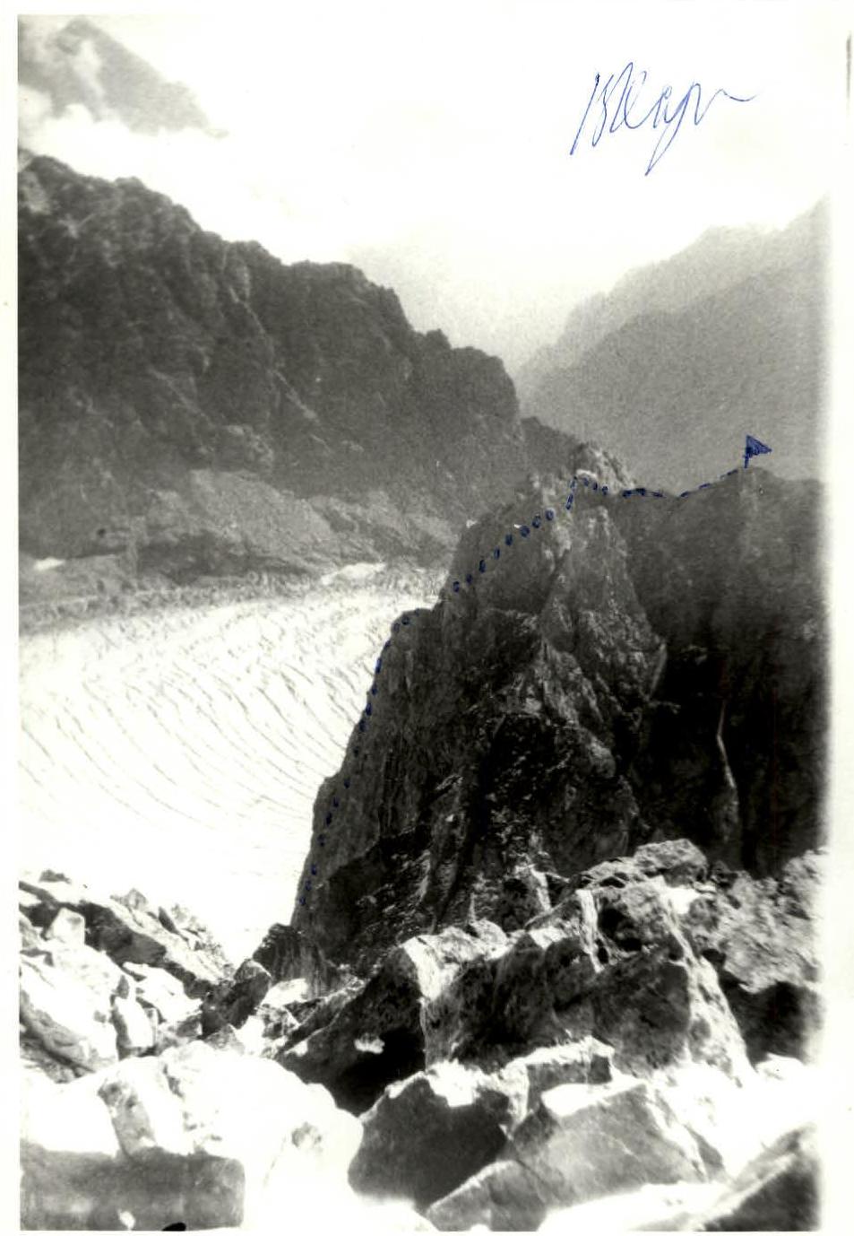
Photo 4. Profile of the buttress from the right. Taken on August 15, 1985, from the peak of Nikolaev, point #4, ~1 km, T-43, P = 40 mm. The rocky summit of Khitsan-khokh is located between the peak of Nikolaev and the Khitsan pass, in the eastern spur of the Mamison peak, which divides the upper Tsey glacier into the Southern and Northern branches. The height of Khitsan-khokh is 3500 m. The summit has a route:
- from the Khitsan pass via the Eastern ridge, category 1B difficulty
- from the Northern Cirque via the N wall and NW ridge, category 4A difficulty
The group chose an unattempted route from the Northern Cirque of the Tsey glacier, following a distinct buttress of the NW ridge. The route is rocky, passes along a protruding buttress, and is safe from falling rocks. The middle and upper parts of the buttress consist of monolithic rocks, often covered with lichen, with a small number of cracks.
Approach to the route description
From the "Tsey" alpine camp, follow a good trail to the Upper Tsey campsite, then ascend through the "ram's foreheads" into the Southern Cirque of the Tsey glacier. Traverse the glacier to the Nikolaev hut, located on the right-hand slope on a rocky slope (3.5–4 hours from the camp). The initial bivouac can be set up at the hut. From the hut, ascend right-upwards via the first couloir and reach the Khitsan pass in 30 minutes. (The group departed from the hut on July 31 at 4:30). Descend from the pass, traverse left, and follow the Northern branch of the Tsey glacier to approach the buttress of the NW ridge of Khitsan-khokh (1 hour from the hut).
Brief description of the route:
- Upon reaching the buttress, bypass it on the right and ascend 100 m via a snow-ice slope, overcoming the bergschrund, to scree shelves that lead left into a chimney with a plug at the top.
- Overcome the chimney (first without a backpack), and exit onto a shelf that goes left-upwards.
- Follow the shelf for 80 m to an internal corner that transitions into a chimney.
- From here, ascend upwards and slightly left — 1 rope length via a wall (first person wears galoshes), then approach a shelf below a 40-meter wall via monolithic rocks with few cracks.
- Ascend the wall, then traverse 15 m right along the shelf.
- From here, ascend 10 m with difficult climbing (initially slightly exposed) without a backpack, wearing galoshes, via monolithic rocks with few cracks. Protection is mainly via chocks.
- Then 15 m left-upwards and 40 m upwards via smooth rocks to an internal corner.
- Ascend the internal corner for 20 m, then turn right and follow a 10 m wall to reach smooth shelves.
- Move upwards-right, approaching an internal corner, and ascend it for 25 m (few cracks for protection).
- Then follow walls with shelves for 40 m upwards to protruding large rocks on the buttress crest.
- From here, slightly right and further upwards "in the off-width" along a crack (protection via chocks).
- Then 50 m left-upwards to the top of the buttress, right of the saddle on the NW ridge.
- From here, a short descent, traverse left, and ascend via a couloir to the saddle between the summit of Khitsan-khokh and a false summit.
- From the saddle, 60 m along the ridge to the summit of Khitsan-khokh.
- Descend from the summit via the Eastern ridge, following the category 1B route to the Khitsan pass, and then to the Nikolaev hut.
UIAA scheme of the ascent route to Khitsan-khokh via the buttress of the NW ridge, M ~ 1:1000
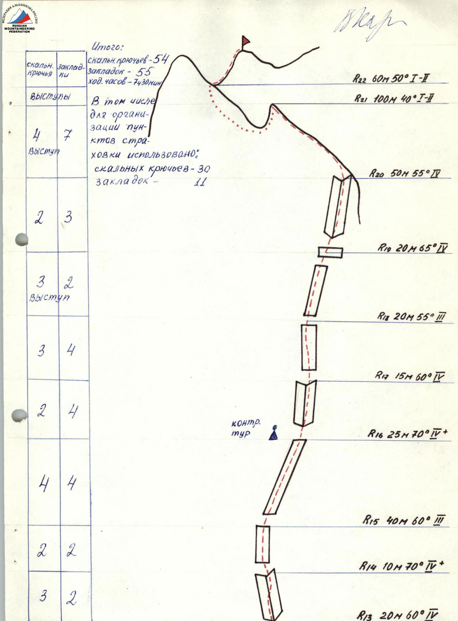
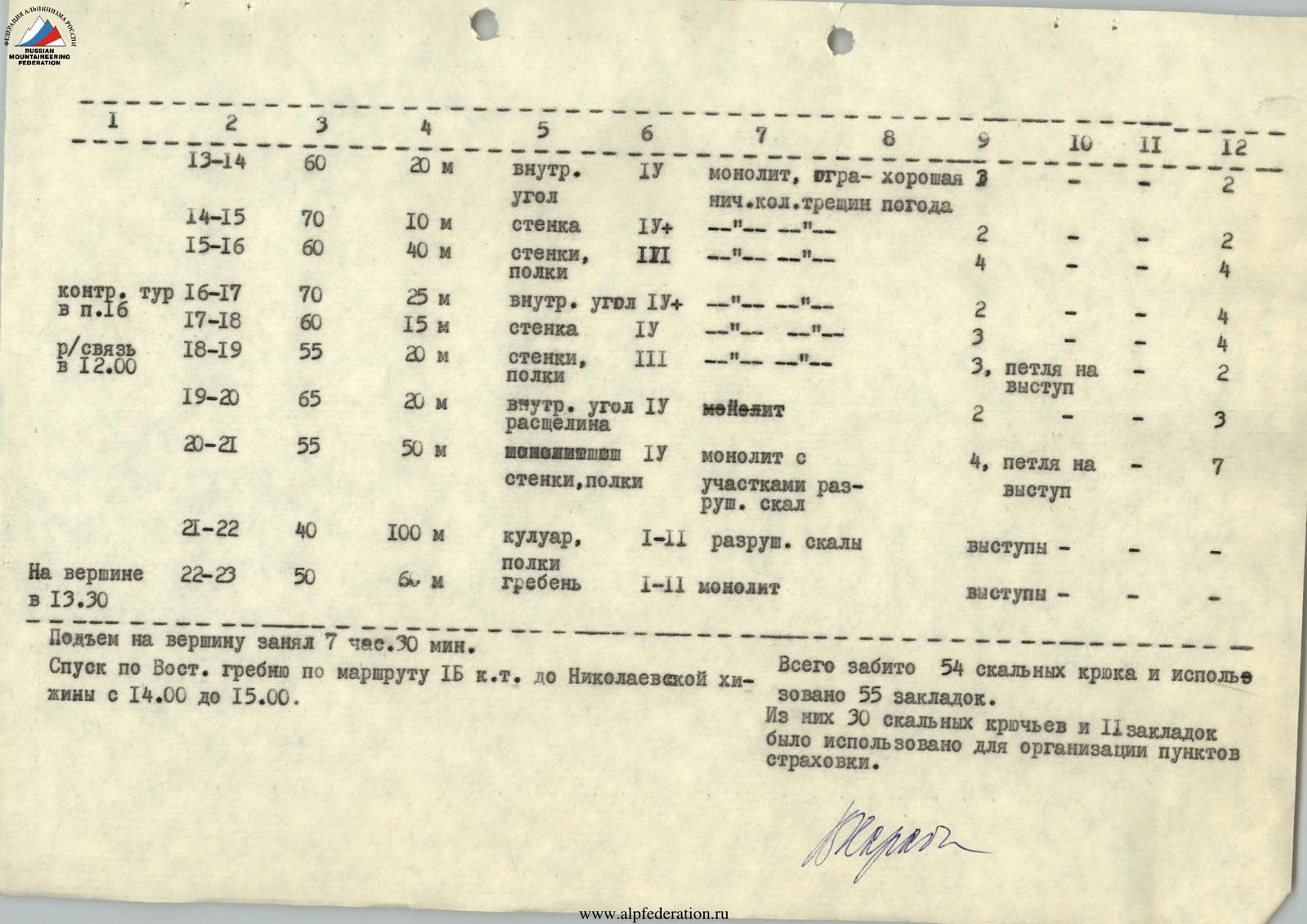
Table I. Main characteristics of the ascent route to Khitsan-khokh via the buttress of the NW ridge, approximately category 5A difficulty
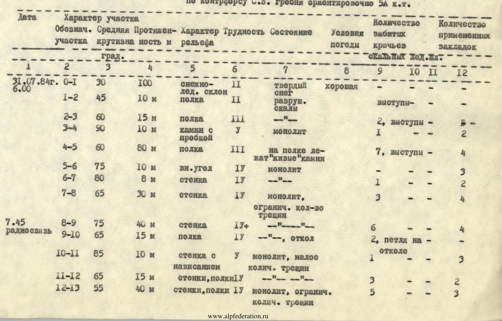
| Date | Section designation | Average steepness, degrees | Length, m | Terrain and relief | Difficulty | Condition | Weather conditions | Number of rock pitons driven | Number of ice/shaft pitons driven | Number of chocks used |
|---|---|---|---|---|---|---|---|---|---|---|
| July 31, 1984 | R0-R1 | 30 | 100 | snow-ice slope | 2 | hard snow | good | |||
| 6:00 | R1-R2 | 45 | 10 m | shelf | 2 | broken rocks | ledges | |||
| R2-R3 | 60 | 15 m | shelf | 3 | --- | 2, ledges | ||||
| R3-R4 | 90 | 10 m | chimney with a plug | 5 | monolith | 1 | 2 | |||
| R4-R5 | 60 | 80 m | shelf | 3 | "live" rocks on the shelf | 7, ledges | 4 | |||
| R5-R6 | 75 | 10 m | internal corner | 4 | monolith | 3 | ||||
| R6-R7 | 80 | 8 m | wall | 4 | --- | 1 | 2 | |||
| R7-R8 | 65 | 30 m | wall | 4 | monolith, limited number of cracks | 3 | 4 | |||
| 7:45 | R8-R9 | 75 | 40 m | wall | 4+ | --- | 6 | 4 | ||
| Radio contact | R9-R10 | 65 | 15 m | shelf | 4 | ---, slab | 2, loop on slab | |||
| R10-R11 | 85 | 10 m | wall with overhang | 5 | monolith, few cracks | 1 | 3 | |||
| R11-R12 | 65 | 15 m | walls, shelves | 4 | --- | 3 | 2 | |||
| R12-R13 | 55 | 40 m | walls, shelves | 4 | monolith, limited number of cracks | 5 | 3 | |||
| R13-R14 | 60 | 20 m | internal corner | 4 | monolith, limited number of cracks | good weather | 3 | 2 | ||
| R14-R15 | 70 | 10 m | wall | 4+ | --- | 2 | 2 | |||
| R15-R16 | 60 | 40 m | walls, shelves | 3 | --- | 4 | 4 | |||
| Control pitch | R16-R17 | 70 | 25 m | internal corner | 4+ | --- | 2 | 4 | ||
| at pitch 16 | R17-R18 | 60 | 15 m | wall | 4 | --- | 3 | 4 | ||
| Radio contact at | R18-R19 | 55 | 20 m | walls, shelves | 3 | --- | 3, loop on ledge | 2 | ||
| 12:00 | R19-R20 | 65 | 20 m | internal corner, crack | 4 | monolith | 2 | 3 | ||
| R20-R21 | 55 | 50 m | monolithic walls, shelves | 4 | monolith with areas of broken rocks | 4, loop on ledge | 7 | |||
| R21-R22 | 40 | 100 m | couloir, shelves | 1–2 | broken rocks | ledges | ||||
| At the summit at | R22-R23 | 50 | 6 m | ridge | 1–2 | monolith | ledges | |||
| 13:30 |
The ascent to the summit took 7 hours 30 minutes. The descent via the Eastern ridge, following the category 1B route, to the Nikolaev hut took from 14:00 to 15:00. A total of 54 rock pitons were driven, and 55 chocks were used. Of these, 30 rock pitons and 11 chocks were used to organize belay stations.