Ascent Passport.
- Caucasus. Rocky ridge. Kionsky massif. Section number in the Classification 2.7.
- Urschoh Central (3290 m) — via the South Terrace of the Western ridge.
- Proposed category: 3A, first ascent.
- Route type — rock.
- Height difference of the route — 430 m (by GPS).
Total route length — about 1250 m. Length of sections with 5th category of difficulty — 10 m. Steepness of key sections — up to 95°. Average steepness of the route — 35°.
- Pitons left on the route — none.
Pitons used on the route — 5. Chocks used on the route — 15.
- Climbing hours — 6; days — 1.
- Leader: Egorin S. V. — Master of Sports
Participants:
- Bekoev E. T. — Climbing badge holder
- Zhirnov D. N. — 1st sports category
- Morozova I. Yu. — Candidate for Master of Sports
- Nogovitsyna A. S. — 2nd sports category
-
Coach: Egorin S. V. — Master of Sports
-
Departure; summit; descent: August 5, 2008.
-
Organization: North Ossetian Search and Rescue Team
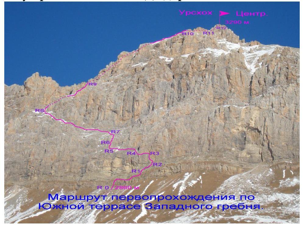
ROUTE DESCRIPTION
From the road turning left (West) towards the Savarafcag pass, start ascending upwards along grassy slopes towards the southern walls of Urschoh Central. One should keep direction under the base of the South Terrace of the Western ridge.
Coordinates of the starting point of the route in WGS-84 format:
| Height | N (North Latitude) hddd mm′ ss.s″ | E (East Longitude) hddd mm′ ss.s″ |
|---|---|---|
| 2860 m | 425410.5 | 0435808.6 |
Section R0–R1: Approach the narrow rocky belt located under the rusty wall with overhangs, below the start of the South Terrace of the Western ridge. Cross the shortest section of rocks to reach a grassy inclined ledge (rocks 1–2 category, 10 m, 60°). Then follow this ledge to the right. The whole section is about 100 m, 1st category, 20–30°.
Section R1–R2: From the ledge, go right upwards, under the grey inner corner located to the right of the overhang belt (rocks 2–3 category, in the middle — a section of 4th category, 2 m). The whole section is 50 m, 30–50°.
Section R2–R3: From the left part of the ledge, located to the right and below the grey inner corner, move upwards along rocks composed of separate yellow blocks — 4 m, 4–4+ category, 80°; and 3 m, 5th category — 90°. After the wall, traverse left 3 m, under the base of the grey inner corner. Along the grey wall with a small number of holds (tense climbing), enter the lower part of the chimney and ascend it to a ledge with a good stance for a belay. Another 20 m, 80–95°, including about 7 m of 5–5+ category, the rest — 4–4+ category.
Section R2–R3 is the key section of the route.
Section R3–R4: Here begins the South Terrace of the Western ridge. From the ledge, traverse left along a narrow talus ledge above rocky drops. In the middle of the section — a psychological obstacle, bypassing a protrusion. At the end of the section, cross right behind a rocky ridge. The whole section is about 50 m, 2–3 category.
Section R4–R5: Ascend along talus ledges under rocks. Under the rocks, start traversing left along talus ledges between rocky belts. After crossing a small snow-talus couloir, move under the base of a rocky ascent. Bypass the base of the ascent from the left. The whole section is about 100 m, 1–2 category.
Scheme of passage:
- Ascend along talus ledges under rocks
- Traverse left under rocks along talus ledges between rocky belts
- Cross a small snow-talus couloir
- Move under the base of a rocky ascent
- Bypass the base of the ascent from the left
Section R5–R6: Continue upwards along the left side of the ascent — along rocky belts with ledges between them; and after 50 m, 1–2 category, 40–60°, reach a ledge under the wall of the ascent. Slightly above the ledge — a control tour.
Section R6–R7: From the ledge, along rocks 2–3 category, approach under a flake, and from it, cross to the main wall — 10 m from the ledge. Further along the right part of the wall, 2–4 category, along grey rocks 50–70° with good holds, and reach talus ledges another 20 m. On the left, a good stance for a belay.
Section R7–R8: Here continues the South Terrace of the Western ridge of Urschoh Central. Along the talus terrace, 1–2 category, move left under overhanging rocks, about 250 m, until the terrace turns right.
Section R8–R9: Along the left part of the terrace, ascend, gradually turning right. The further path goes along snow-talus slopes right-upwards, towards fancifully weathered rusty rocks. After about 100 m, turn left and along a talus couloir, exit onto the Western ridge of Urschoh Central. The whole section is about 150 m, 1–2 category, 20–40°.
Section R9–R10: Continue along the Western ridge, 1–2 category, upwards, mainly along its left, Northern, side. In case of abundant snow, the Northern slopes are avalanche-prone!
After about 300 m, approach the pre-summit pinnacle.
Section R10–R11: Bypass the first ascent of the pre-summit pinnacle from the right. The second ascent — from the left, along the Northern slope, slightly below the ridge line — snowy slabs 2–3 category. And after 60 m from the start of the section, exit under the summit ascent.
Section R11–R12: Further along a 30 m slope, 1–2 category, 20–30°, ascend to the summit of Urschoh Central 3290 m.
From the summit, an excellent panorama unfolds. Visible peaks:
- Kalper
- Shau
- Jimaray
Arkhon - Tepli massif, Cmiakomkhoh. To the West, visible are Laboda and Sugansky ridge.
From the start of the route to the summit — about 6 hours. Descent follows the ascent route until the pre-summit pinnacle. Behind it, turn left and traverse along southern slopes to the saddle between the summits of Urschoh Central and Urschoh Eastern. Further descent follows the route of 2A category to the summit of Urschoh Eastern. To the road — about 5 hours.