
Ascent Passport
-
Caucasus. Rocky Ridge. Kionsky Massif. Classification section number 2.7.
-
Urskhok West (3229 m) – Urskhok Central (3290 m) – via the Western ridge, traverse.
-
Proposed 3A category of difficulty, first ascent.
-
Route type — rock climbing.
-
Route elevation gain — 510 m (by GPS).
Total route length — about 2000 m. Length of sections with 3–4 category of difficulty — 80 m. Steepness of key sections — up to 70°. Average steepness of the route — 30°.
-
Pitons left on the route — none.
-
Climbing hours — 9; days — 1.
-
Leader: Egorin S. V. — Master of Sports Participants: 4 special unit employees.
-
Coach: Egorin S. V. — Master of Sports
-
Approach to the route, summit, descent: July 14, 2013.
-
Organization: North Ossetian Search and Rescue Team of EMERCOM of Russia.
-
Leader's contact information for report inquiries:
phone: +7 928 490-31-28; email: e.s.128@mail.ru
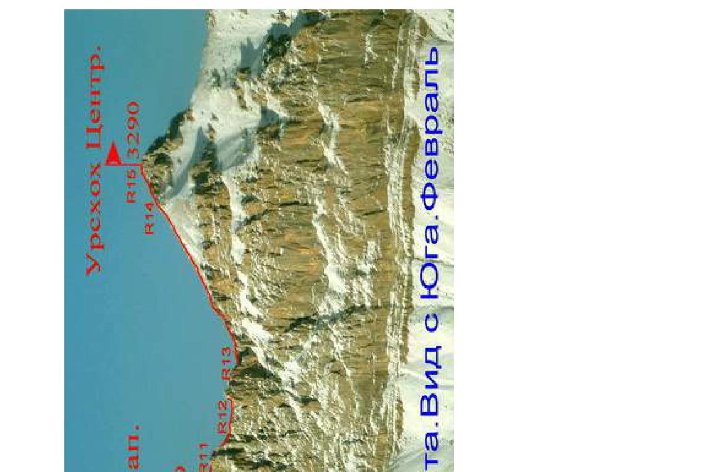
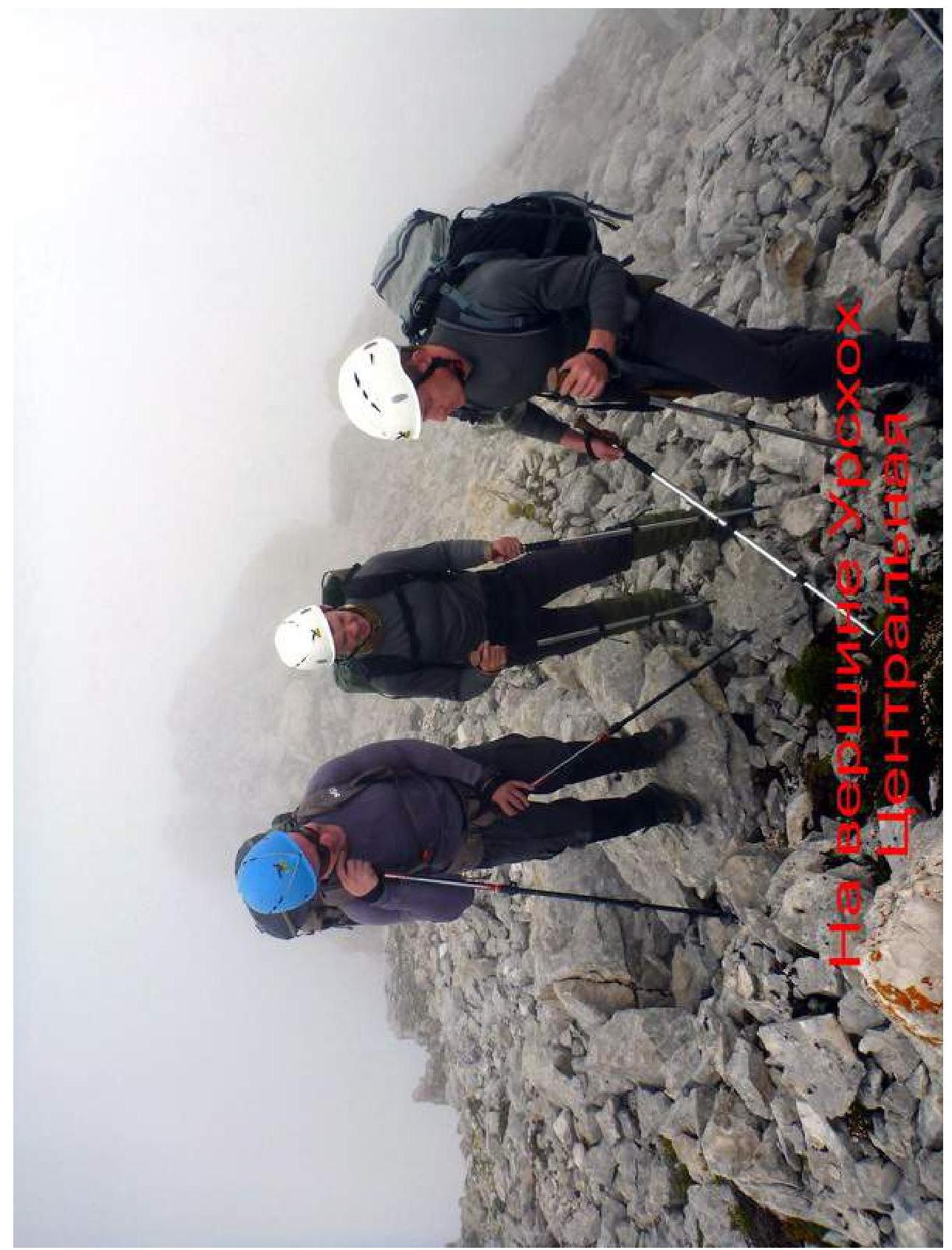
Urskhok Center.

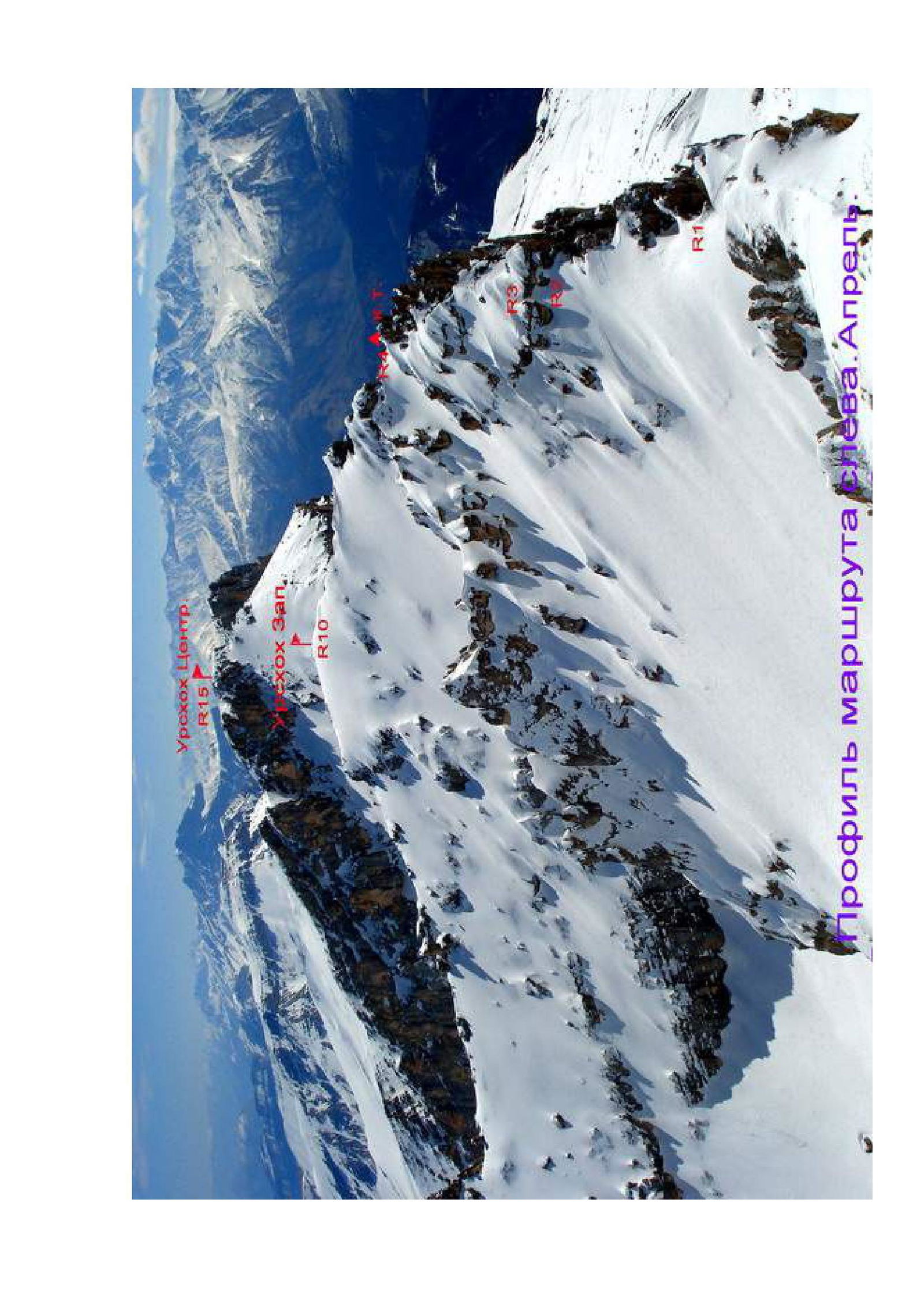
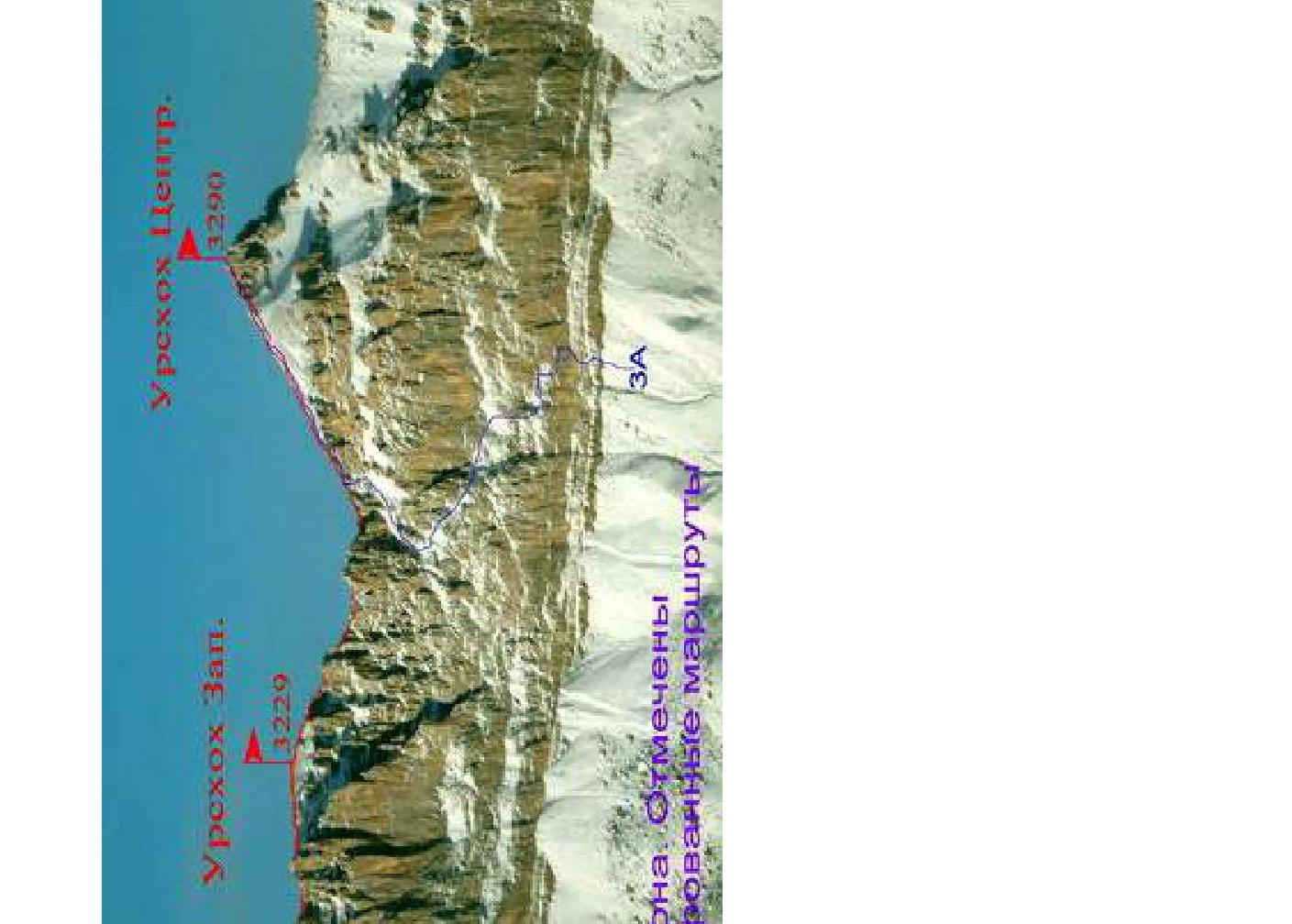
Photo panorama of the area. Nearest classified 3A routes are marked.
Kionsky Massif — brief overview of the area
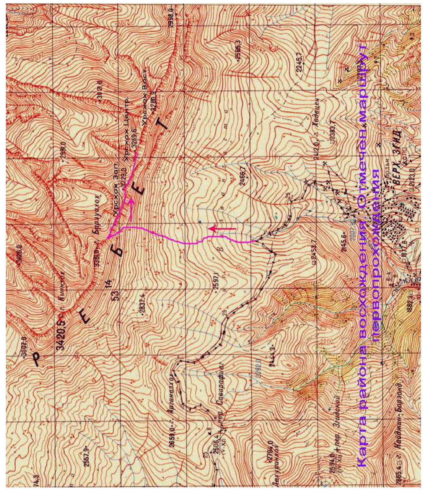
The Kionsky Massif is located in the Republic of North Ossetia — Alania, between the Ardon River to the East and the Urukh (Iraf) River to the West. The Kionsky Massif is part of the Rocky Ridge, which is well-defined in Kabardino-Balkaria and North Ossetia.
The entire Kionsky Massif stretches from Northwest to Southeast for 30 km. Its highest point is the peak Kionkhokh, 3421 m.
Numerous small rivers flow from the northern slopes of the massif, belonging to the Terek River basin. The massif is relatively undeveloped from the north, with rare roads and difficult, lengthy approaches.
To the south, the Kionsky Massif drops steeply with walls having a height difference of 100 to 300 m. Below the walls lie alpine meadows.
The rocks composing the Kionsky Massif are sedimentary in origin — limestones and dolomites, with marble found in some places. The rocks are mostly degraded and heavily weathered. Therefore, the ridge crest is heavily serrated. Fossilized mollusk shells can often be found in the scree on the slopes.
Due to the weathering of the rocks, the slopes of the massif have a lot of scree. The highest point of the massif, Kionkhokh, translates from Ossetian as "slabby, scree mountain".
The climate of the Rocky Ridge is specific and differs from the rest of the North Caucasus mountains. Cyclones coming from the north release most of their precipitation on the northern slopes of the Rocky Ridge, while those coming from the south mostly discharge on the Lateral and Watershed ridges.
The climate on the southern slopes is much drier than on the northern slopes due to the formation of a so-called "rain shadow" zone. Thanks to this and the southern exposure, snow melts quickly even in winter on the southern walls.
The most interesting part of the Kionsky Massif from a sports perspective is its central section, starting from the peaks Barzond – Tsagveri to the peaks Urskhok above Upper Zgid. This part of the ridge has peak heights over 3000 m for almost 10 km.
Since the mid-1990s, climbers from North Ossetia have been actively exploring the central part of the Kionsky Massif. Due to the convenience of access, all routes have been climbed from the south. It takes 1.5–2 hours to get from Vladikavkaz to the village of Upper Zgid. A regular bus runs to this village once a day in the afternoon and returns early in the morning.
It is possible to drive further above the village, but only in high-clearance vehicles. In such cases, it takes about half an hour to walk from the vehicle to the overnight camps under Urskhok.
The routes in the area are convenient for climbing in winter and during the off-season:
- close approaches;
- ascents can be made in virtually any weather;
- most routes are ridge routes and are generally not avalanche-prone.
There is Megafon cellular coverage on the routes and at overnight camps. To date, 10 classified routes have been climbed in the central part of the Kionsky Massif. Of these:
- four on Urskhok East;
- four on Urskhok Center.
- Urskhok Center from the South — 1B category of difficulty.
- Urskhok Center via the Southern terrace of the Western ridge — 3A category of difficulty.
- Urskhok East via the Western ridge — 2A category of difficulty.
- Urskhok East via the Eastern ridge — 1B category of difficulty.
Until July 2013, there were no ascents on Urskhok West. This report describes the first ascent route for the traverse of Urskhok West — Urskhok Center.
Description of approaches to the route
It takes about 2–2.5 hours to get from Vladikavkaz to the village of Upper Zgid by regular bus. After passing through the village, head north towards the visible Rocky Ridge. The path follows a drivable dirt road that leads through the Savarafcag pass (2506 m) to the neighboring valley of the Aygamugidon River to the villages of Dunta, Kamunta. Half an hour from Upper Zgid, start climbing north. The road turns left, west towards the Savarafcag pass.
Continue straight up towards the triangular peak of Urskhok Center. Climbing along the river from the road, you can camp at the end of the stream formed by springs that do not freeze even in winter. It takes about an hour to get from the road to the campsite.
GPS coordinates for the campsite in WGS-84 format:
| Elevation | N (North latitude) | E (East longitude) |
|---|---|---|
| 2530 m | 42° 53.637′ | 043° 58.185′ |
Characteristics of route sections
| Section | Length (m) | Steepness, ° | Terrain characteristics | Category of difficulty | Number of pitons |
|---|---|---|---|---|---|
| R0–R1 | 300 | 20–50 | Rocky-scree slope. | 1–3 | - |
| R1–R2 | 100 | 20–30 | Rocky-scree ridge | 1 | - |
| R2–R3 | 15 | 40–60 | Chimney | 2–4 | 2 |
| R3–R4 | 150 | 20–40 | Rocky-scree slope and ridge | 1–2 | - |
| R4–R5 | 100 | 20–30 | Rocky-scree ridge | 1–2 | - |
| R5–R6 | 25 | 50–70 | Rocky internal corner | 3–4 | 2 |
| R6–R7 | 60 | 20–40 | Rocky-scree slope | 1–2 | - |
| R7–R8 | 50 | 30–50 | Rocky-scree slope | 1–3 | 1 |
| R8–R9 | 200 | 20–30 | Rocky-scree ridge | 1–2 | - |
| R9–R10 | 200 | 20–30 | Rocky-scree ridge | 1–2 | - |
| R10–R11 | 150 | 20–30 | Rocky-scree slope | 1–2 | - |
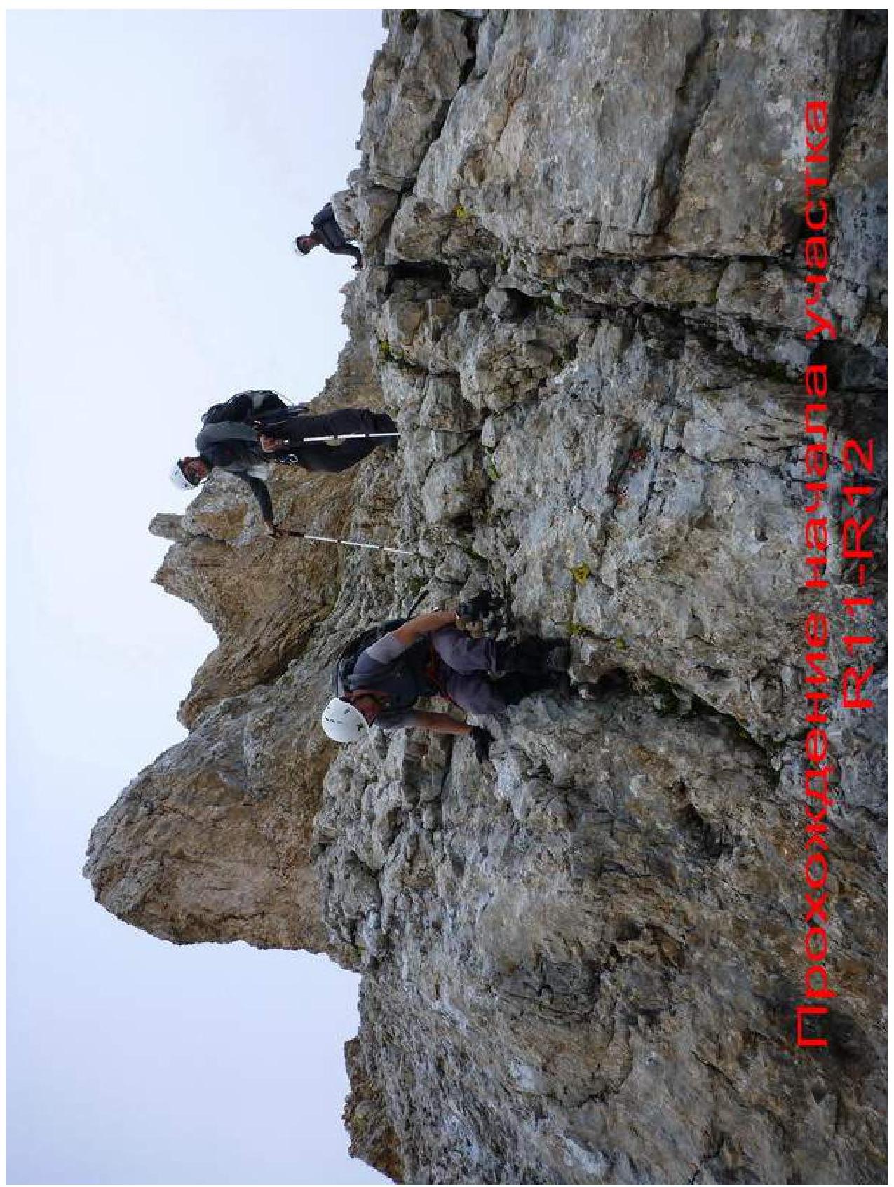
| R11–R12 | 120 | 20–50 | Rocky-scree ridge | 1–2 | - |
| R12–R13 | 80 | 20–60 | Rocky-scree ridge | 1–4 | 2 |
| R13–R14 | 350 | 20–30 | Rocky-scree ridge | 1–2 | - |
| R14–R15 | 100 | 20–50 | Rocky-scree ridge | 1–3 | 3 |
Route description by sections
From the campsite under Urskhok Center, head west towards the col between Barzui-khokh and Urskhok West.
It's better to walk along the boundary between alpine meadows and scree. The starting point for climbing the Kionsky Massif ridge is a point with GPS coordinates:
| Elevation | N (North latitude) | E (East longitude) |
|---|---|---|
| 2950 m | 42° 54.335′ | 043° 57.598′ |
A visual landmark for the start of the ascent is the narrowest point in the southern walls.
R0–R1: Straight up through a narrow rock band (10 m, 2–3) composed of degraded limestone, exit onto a scree slope. Climb further under the rocks and move left up under the walls for about 200 m, until reaching the col of the Kionsky Massif. The entire section is about 300 m, 1–3, 20–50°.
R1–R2: On the col, turn right and follow the northern slopes of the Western ridge to approach a rock band with a chimney in the middle. Section 100 m, 20–30°, 1.
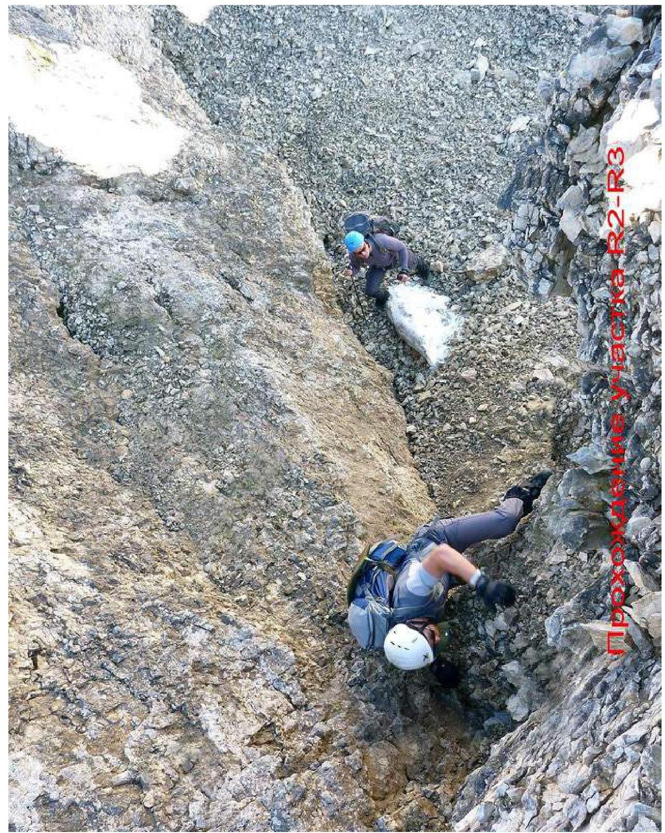
R2–R3: Climb further up through the left part of the chimney, 2–4, 15 m, 40–60°.
R3–R4: After the chimney, move right up onto the Western ridge. Continue straight along the ridge, bypassing complex sections on the left, through a series of small degraded gendarmes, to approach the upper part of the Western ridge ascent. Here is a control cairn. Further, the ridge descends slightly. The entire section is about 150 m, 20–30°, 1–2.
R4–R5: Descend along the ridge line towards a double gendarme. Reach a narrow saddle between the gendarmes. Section 100 m, 20–30°, 1–2.
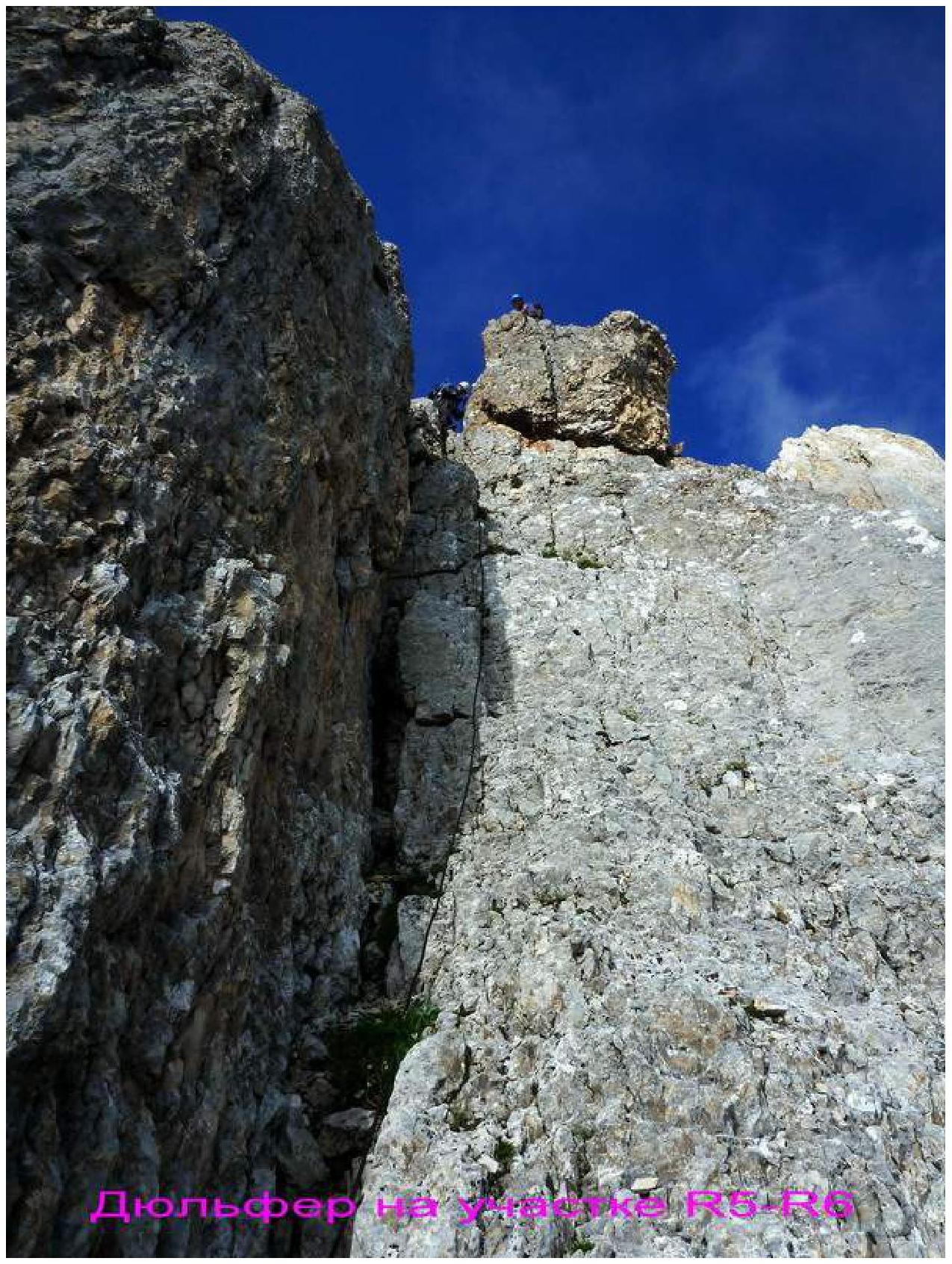
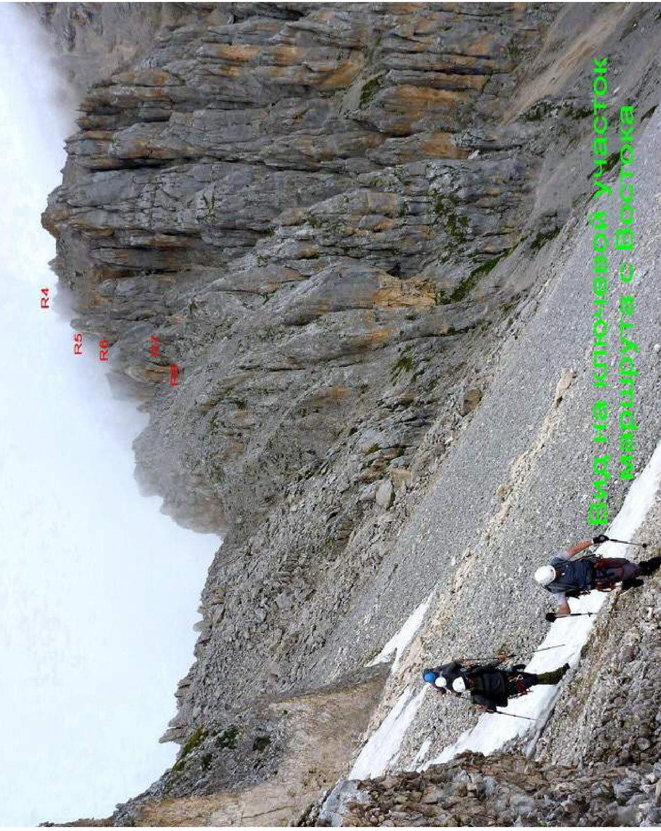
R5–R6: On the saddle, there is a rock "finger". From it, rappel straight down along a vaguely defined internal corner. Down the rocks 3–4, 50–70°, 25 m to a narrow ledge.
R6–R7: Along the ledge, move right under the rust-colored walls until reaching the ridge behind a triangular gendarme (40 m). Then descend 20 m left down, left of the ridge line, towards a sharp slope bend to the east. The entire section is 20–40°, 1–2. The rocks are degraded — movement is variable.
R7–R8: Further movement is right down — descent into a rock corrie. Belaying is difficult — you can use the slope bend and belay from the ridge. The descent is along degraded rocks 2–3, 40–50°, about 10 m. After descending, cross the corrie and climb onto the northern slope of the Western ridge. The entire section is 50 m. Sections R5–R8 are the key sections of the route to the summit of Urskhok West via the Western ridge.
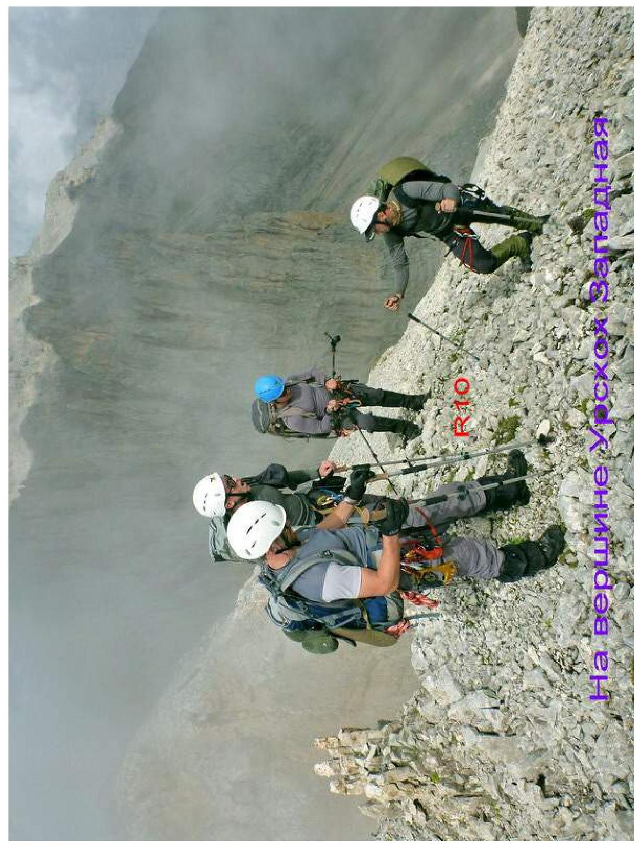
R8–R9: Along the northern slopes of the Western ridge, sometimes exiting onto the ridge line, move 200 m east to the pre-summit ascent. Section 1–2, 20–30°.
R9–R10: Bypass the rock outcrops of the pre-summit ascent on the left, along the northern slopes. Avalanche danger with significant snow! Behind the rock outcrop, exit onto the Western ridge and climb 200 m from the start of the section to the summit of Urskhok West. The entire section is 1–2, 20–30°. The summit is a wide scree dome. No signs of human presence were found.
R10–R11: From the summit of Urskhok West, descend east, left of the ridge line, bypassing gendarmes. After 150 m, 1, 20–30°, approach a rock step.
R11–R12: Overcome the step by climbing — 5 m, 2–3, 50°. Then continue along the northern slopes to a gap in the ridge, another 120 m, 1, 20–30°.
R12–R13: Pass through the gap by descending along rocks 10 m, 3–4, 50–60° (rappel). Bypass the next gendarme on the left along inclined slabs 1–3, 20–30° with fine scree on them. Belay! Below are drop-offs. After traversing the slabs, exit back onto the ridge. The entire section is 80 m.
R13–R14: Continue along the rocky-scree ridge 1–2, 20–30°, towards the summit of Urskhok Center. Bypass the start of the rock tower from the south until reaching the saddle of the ridge. The entire section is 350 m.
R14–R15: Here, turn right and along the left (northern) side of the ridge, through rocks 11–3, 30–50°, exit back onto the ridge line. Further, the narrow ridge is bypassed on the left along rocks 2–3, then exit onto the ridge and along the western slope of the pre-summit tower 1–2 to the top, 20–40°. The summit is 30 m to the left. The entire section is 100 m.
Descent from the summit of Urskhok Center along the 1B category of difficulty route.
Conclusions and recommendations for the route
The route is recommended for training ascents by sports groups and for educational ascents.
Based on the route length, characteristics of key sections, and comparing it with nearby 3A category of difficulty routes, it can be asserted that the first ascent route corresponds to a 3A category of difficulty route.
When climbing the route, follow the description precisely to avoid encountering complex sections.
With significant snow, bypassing the ridge from the northern side becomes avalanche-prone. Stay along the rocks!
Equipment recommendations:
- Cams;
- 50 m ropes;
- Loops for organizing stations and rappelling.
Digitized by Google
Digitized by Google
Digitized by Google


Digitized by Google