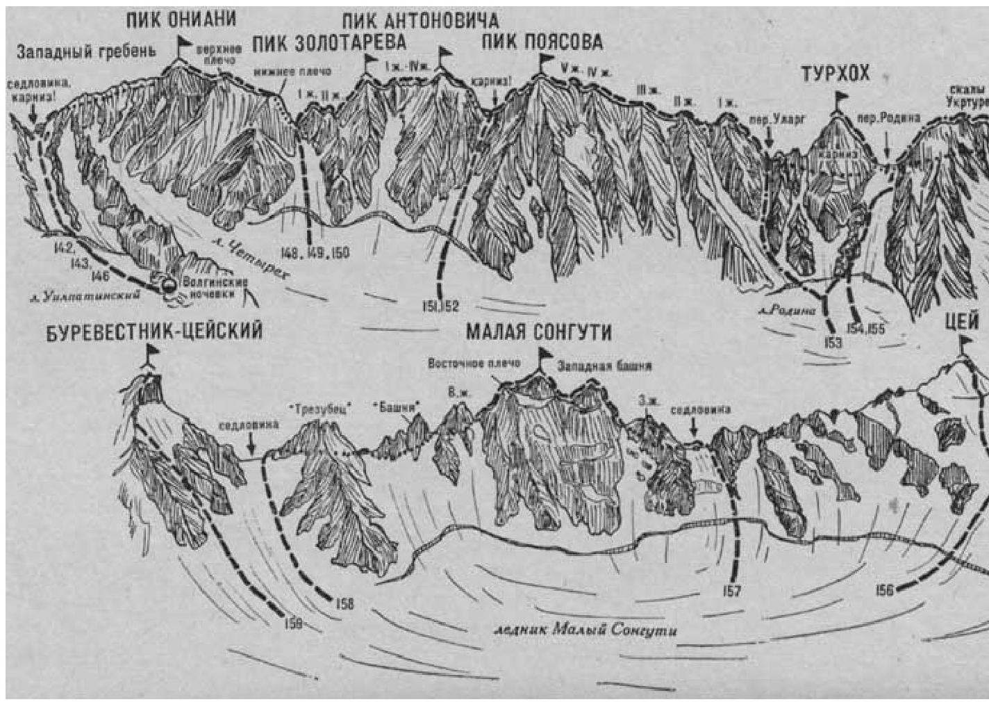
Malaya Songuti
The Malaya Songuti peak (3800 m) is located in the eastern part of the Tsey range between the Pik Burevestnik - Tseysky peak to the east and the Tsey peak to the west.
From the southern side:
- The rock walls of Malaya Songuti are heavily destroyed
- The walls are dissected by deep, narrow couloirs
- Rockfalls often occur towards the Tsey gorge
From the northern side:
- The rock towers of Malaya Songuti rise beautifully above the Maly Songuti glacier
- The Maly Songuti glacier feeds the Turye lake
- Songuti Malaya via the Western ridge, 4A cat. difficulty (A. Durnov, A. Zolotarev, Z. Kritskaya, S. Makarova, A. Turchin, August 15, 1952, during a traverse from west to east).
The path from the KSP of the Tsey region (group of 4-8 people) to the initial bivouac on the platforms near the Turye lake under the Maly Songuti glacier is described in route 156.
From the Turye lake, reach the large rock in the Maly Songuti glacier cirque. Turn right at the rock and approach the saddle of the Tsey ridge between the Malaya Songuti peak to the left and the Tsey peak to the right via the glacier. Rockfall and avalanches are possible from Malaya Songuti. 1-2 hours from the initial bivouac near the lake.
Cross the bergschrund via a snow bridge from the glacier (with protection). To the right of the ice front - a descent along the right side of a steep ice-snow slope, sticking to the rocks of the right buttress (avalanches possible, rockfall from the right - protection), 180-200 m ascent to the platforms on the right side of the saddle. 2-2.5 hours from the glacier. There is water on the southern side of the saddle.
On the saddle, turn left and, after passing a small gendarme, approach the I Western - gendarme of the Western ridge of the Malaya Songuti peak. Traverse the gendarme 200 m to the right along the scree shelves and heavily destroyed rocks, sometimes of medium difficulty (rockfall possible, piton protection). Behind the gendarme, reach the col of the Western ridge under the Western tower of the peak. There may be a snow cornice on the col. 2-2.5 hours from the saddle.
From the col, go up and to the right along a wide shelf, from the end of which 40 m up and to the left along rocks of medium difficulty to an internal corner. Along the vertical internal corner (key point of the route - piton protection), then along steep rocks of medium difficulty, 70-80 m ascent to the Southern buttress of the Western tower.
From here:
- along a sharp 40-meter buttress (key protection),
- then along simple 20-meter rocks, ascent to the Western tower. Cairn.
1.5-2 hours from the col.
From the Western tower:
- along steep destroyed rocks of medium difficulty of the ridge («live» rocks - protection), 50-60 m descent,
- with a 30-meter rappel to a narrow, possibly snow-covered (cornice) col under the western wall of the summit tower.
From the col, along a short sharp edge, approach the wall. 10-12 m up from the edge along the left side of the wall (difficult section of the route - piton protection) to a protruding slab. Above the slab, move to the right side of the wall and along rocks of medium difficulty of the edge, then along its right side, ascend 80 m («live» rocks - piton protection) to the snow cap and from it to the summit of Malaya Songuti.
1.5-2 hours from the Western tower. 7-9 hours from the platforms near the lake.
Descent via the Eastern ridge (see route 158). Duration of the route is 3 days.
Naumov A. F. Karagom, Digoriya, Tsey (Central Caucasus), M., "Fizkultura i sport", 1976.