Ascent Log
-
Climbing category — rock.
-
Climbing area: Caucasus, Skalisty Range.
-
Peak Kion-Khokh (3421 m), via the Western ridge.
-
Estimated category complexity 2B, first ascent.
-
Height difference: 400 m — including: the actual wall section — 40 m. Total route length — 1200 m. Length of the wall section — 60 m. Of which: category 5 complexity — 2 m. Average steepness of the wall section — 75°. Average steepness of the route — 30°.
-
Pitons hammered on the route: rock — 6/0.
-
Number of climbing hours/days: 6/1.
-
Overnight stays: none.
-
Leader: Egorin Sergey Vladimirovich, Candidate for Master of Sports
Participants: Afanasyev Igor Slavyнович, Candidate for Master of Sports; Bezyaev Vitaly, 3rd sports rank; Bondarenko Alexander Olegovich, 3rd sports rank; Bychkov Boris Nikolayevich, 3rd sports rank; Sushko Alexander Pavlovich, Master of Sports
-
Coach: Korablin Boris Nikolayevich, Master of Sports, Honored Coach of the RSFSR.
-
Departure to the route: February 17, 1995.
Summit — February 17, 1995. Return — February 17, 1995.
-
Organization: North Ossetian Republican Search and Rescue Service of the EMERCOM of Russia.
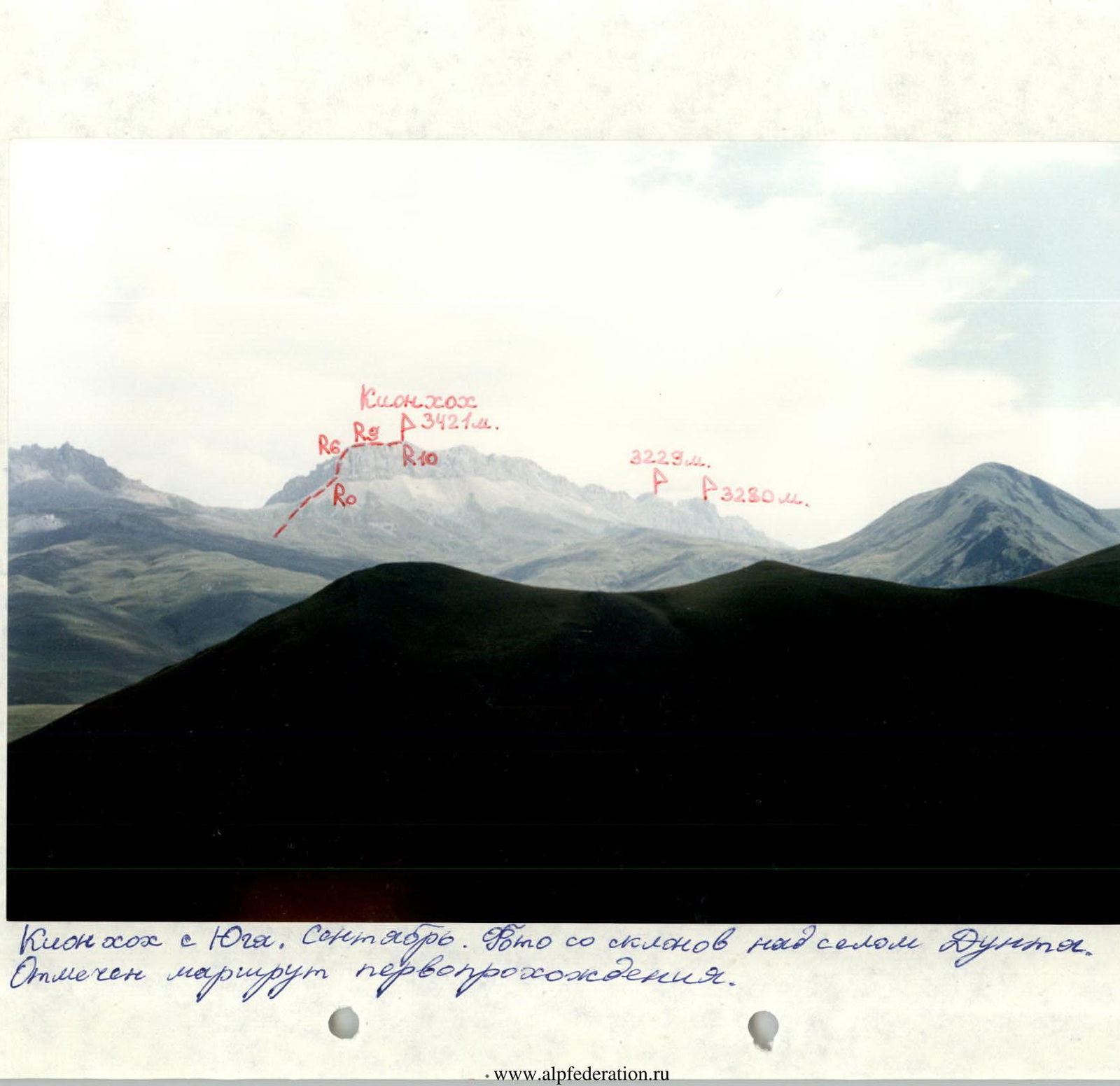 Kion-Khokh from the south. September. Photo from the slopes above the village of Dunta. The first ascent route is marked.
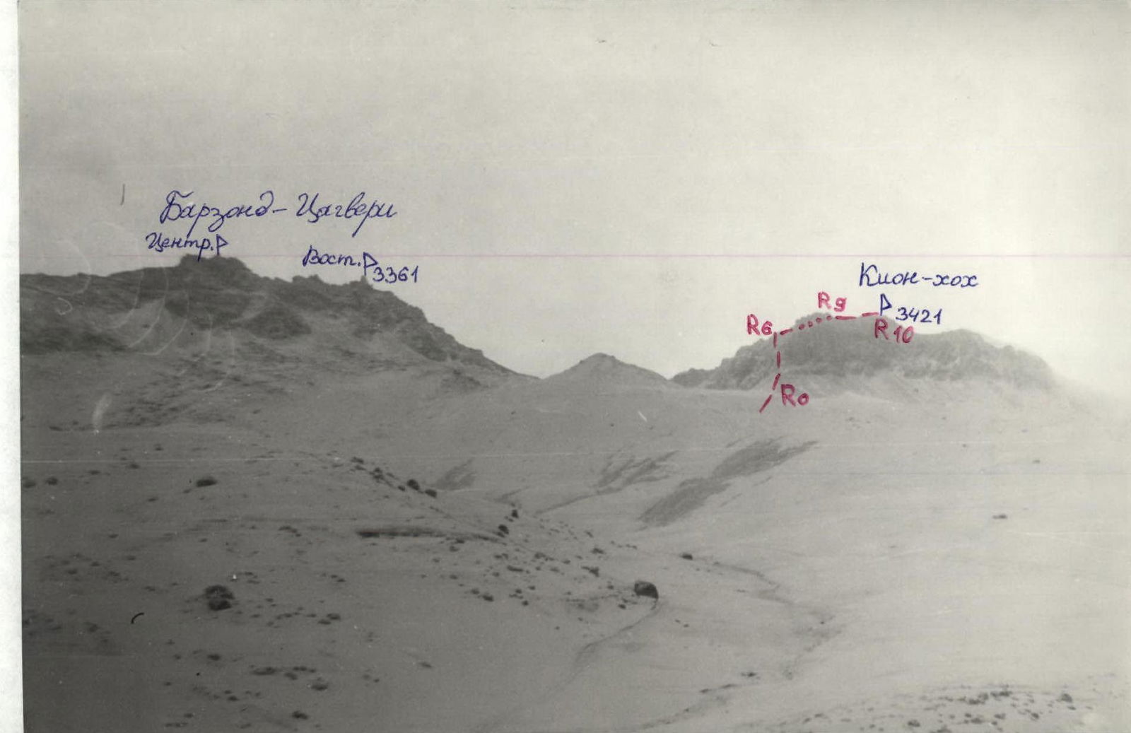 View to the northeast from the village of Kamunta. The first ascent route is marked. April, after snowfall.
 1:100 000. In 1 cm: 1 km.
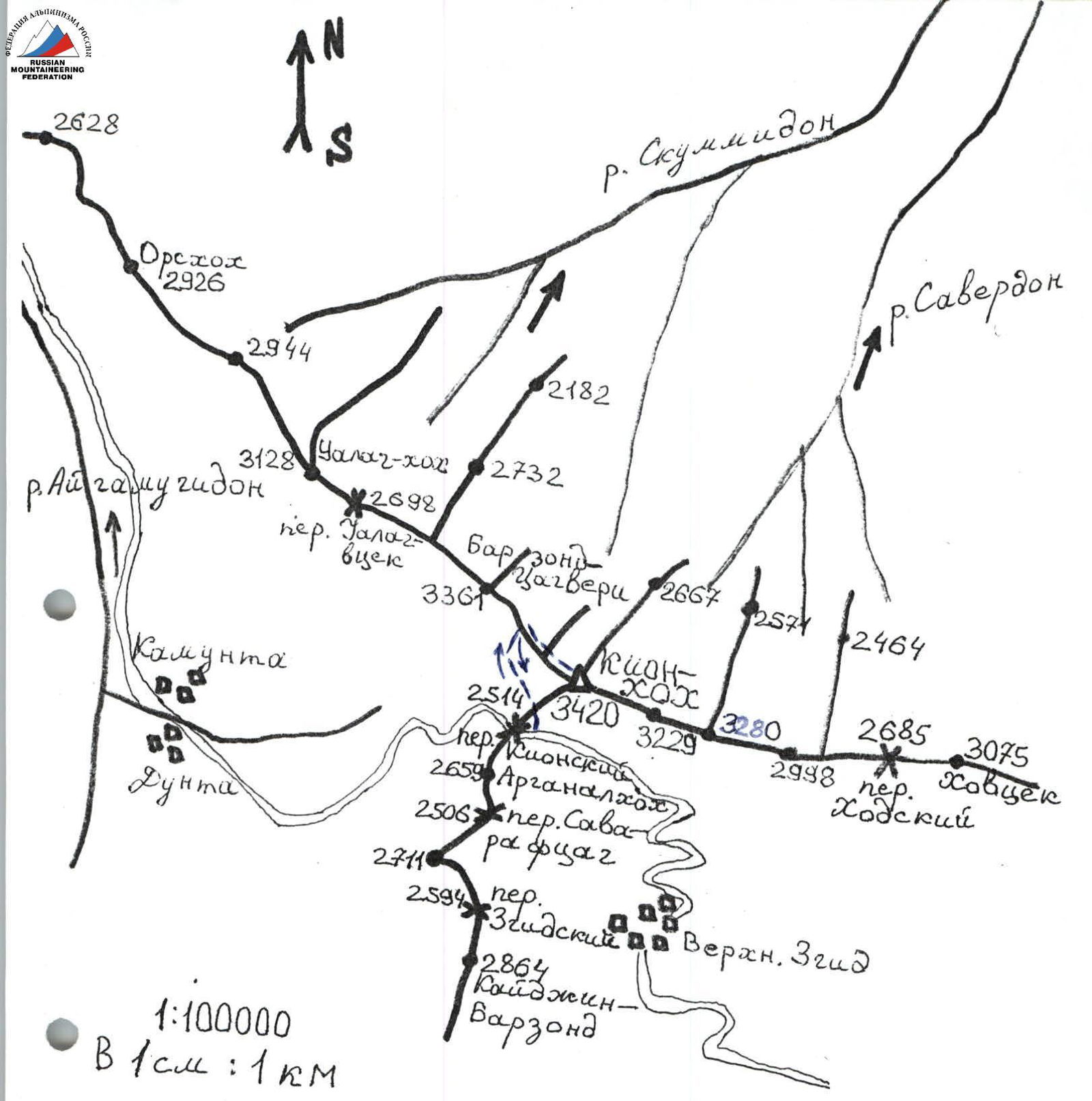
Description of the Approach to the Route
From the village of Verkhny Zgid (reachable by bus from Vladikavkaz in 2.5–3 hours) via a dirt road to Kion Pass (2514 m):
- By car — about 45 minutes.
- On foot — 2–3 hours.
After crossing the saddle, the road turns west towards the villages of Fasnal, Kamunta, and Dunta. Our path from the pass goes north — straight up. After about half an hour:
- move left — up (northwest) along grassy-scree slopes
- or, reaching the southern destroyed walls of Kion-Khokh that stretch far to the east, follow them left (west) along small scree (difficult).
Moving upwards, we reach the saddle between:
- the western wall of the Western ridge of Kion-Khokh peak on the right
- the heavily serrated ridge of Barzond-Tsagveri peak (3361 m) on the left.
From Kion Pass to this saddle — 2–3 hours. Water is available in springs on the southern slopes, before reaching the ridge.
On the saddle (altitude 3000 m):
- turn right
- move along the scree towards the wall of the Western ridge of Kion-Khokh peak.
In the middle, this wall is cut by a deep rock chimney-couloir. Approaching it, we go around its right walls from the south (1).
View from the south
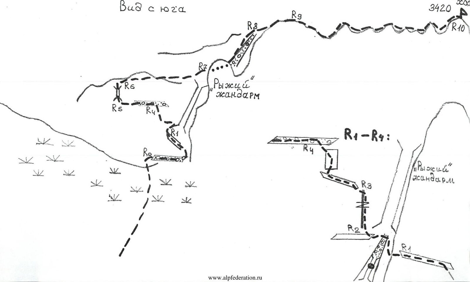
Route Description
Section R0–R1: Bypassing the right rocks that bound the chimney on the right (from the south), approach a small 3 m wall, 2+, and from it reach a ledge that leads left under the wall of the "Red Gendarme". Descend along the ledge (2) into the chimney-couloir.
Section R1–R2: Cross the chimney-couloir in its upper part (wall 2–3, 3 m) and reach a ledge under a cleft.
Section R2–R3: Move straight up along the cleft, sticking to its right part (4–5, 25 m up to 85°).
Section R3–R4: Having passed the cleft (in its upper part it narrows into a crack), move left along the ledge (3), then up the wall via a system of ledges (3).
Hazards:
- Scree on the ledges
- "Live rocks"!
Section R4–R5: Left along the ledge under the ridge wall to a chimney (ledge 2).
Section R5–R6: Up the chimney (4 m, 4) to the ridge. Here is a control cairn.
Section R6–R7: Along the ridge (2–3), sticking to the left side, to a couloir.
Section R7–R8: Up the scree couloir (2) on its left part, exit to the ridge.
Section R8–R9: Along the northern slopes of the Western ridge to reach the main ridge (path 2–2+).
Section R9–R10: Along the Western ridge through numerous gendarmes, bypassing them mainly on the left, ascend to the summit of Kion-Khokh (path from 2 to 4). From the start of the ascent, 6–7 hours.
Descent via the ascent route, to the road 3.5–4 hours. Rappelling on sections R2–R4 (about 40 m).