Ascent Passport
- Rock class.
- Caucasus, Rocky ridge, Kionsky massif.
- Barzond – Tsagveri East (3361 m) – Central (3350 m) – West (3337 m), traverse.
- Assumed – 3B category of difficulty, first ascent.
- Elevation difference: 700 m. Length about 3 km. Average slope on the route is about 30°.
- Pitons hammered: rock 8/0, chocks 10/0, ice 0/0, bolted 0/0. Left on the route (rappel loops): rock – 6; chocks – 0.
- Team's travel hours – 10 h, days – 1.
- Overnight stay: under the route, on the southern slopes – comfortable.
- Leader: Egorin Sergey Vladimirovich – CMS. Participant: Abisalov Anatoly Dmitrievich – 2nd sports category.
- Coach: Egorin S.V. – CMS. All from Vladikavkaz.
- Approach to the route: May 2, 1999. Summits: May 2, 1999. Return to base camp: May 2, 1999.
- Organization: North Ossetian Republican Search and Rescue Service of the EMERCOM of Russia. Address: 362035, Vladikavkaz, pr. Kosta 273, SORPSS.
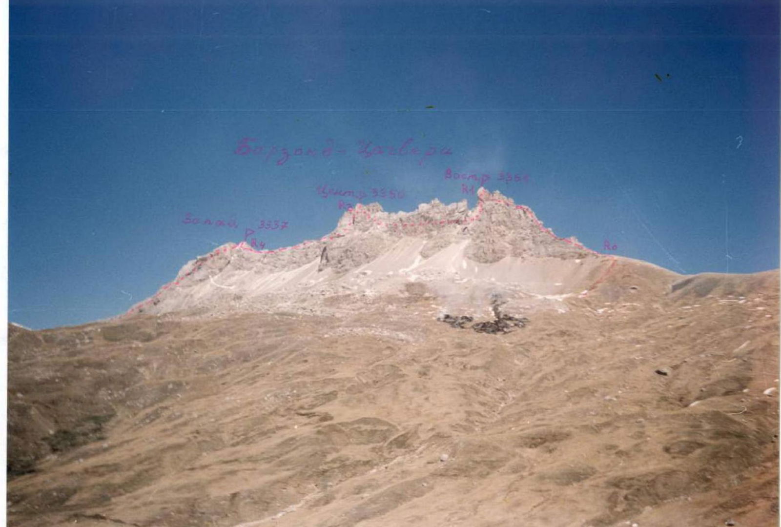
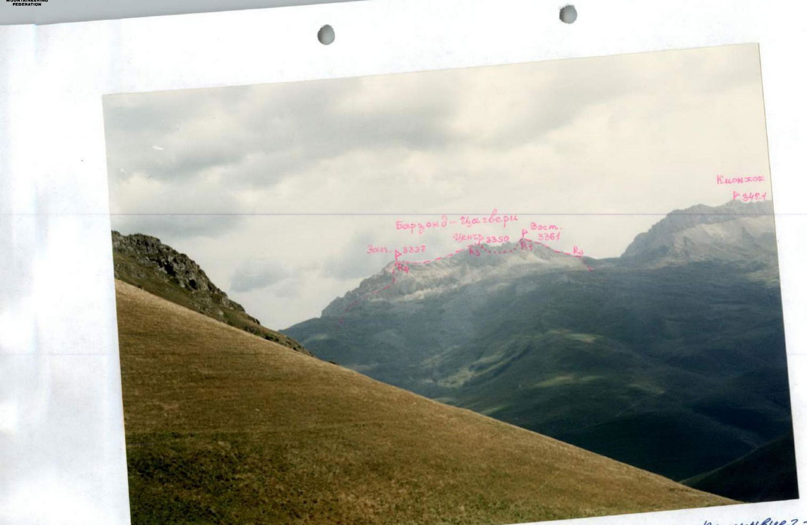
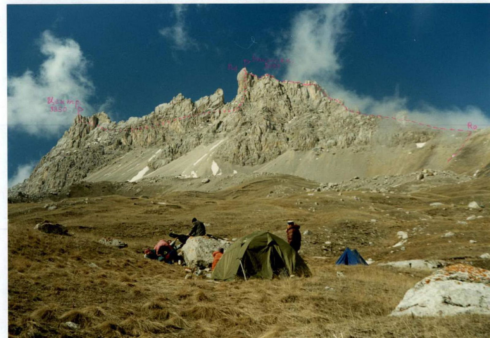
View of the traverse route from the Southeast, from Kionsky Pass. May.
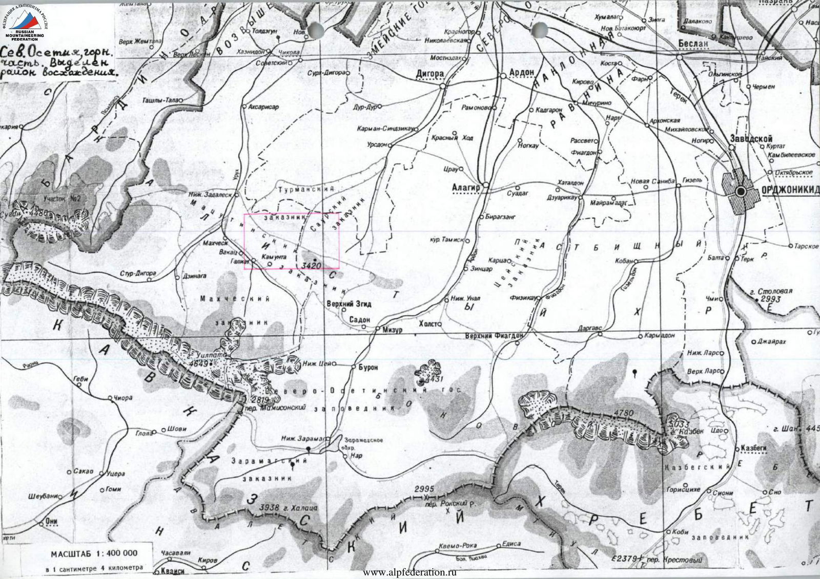
North Ossetia, mountainous part. The ascent area is highlighted.
SCALE 1:400 000
1 centimeter = 4 kilometers.
Brief Overview of the Ascent Area
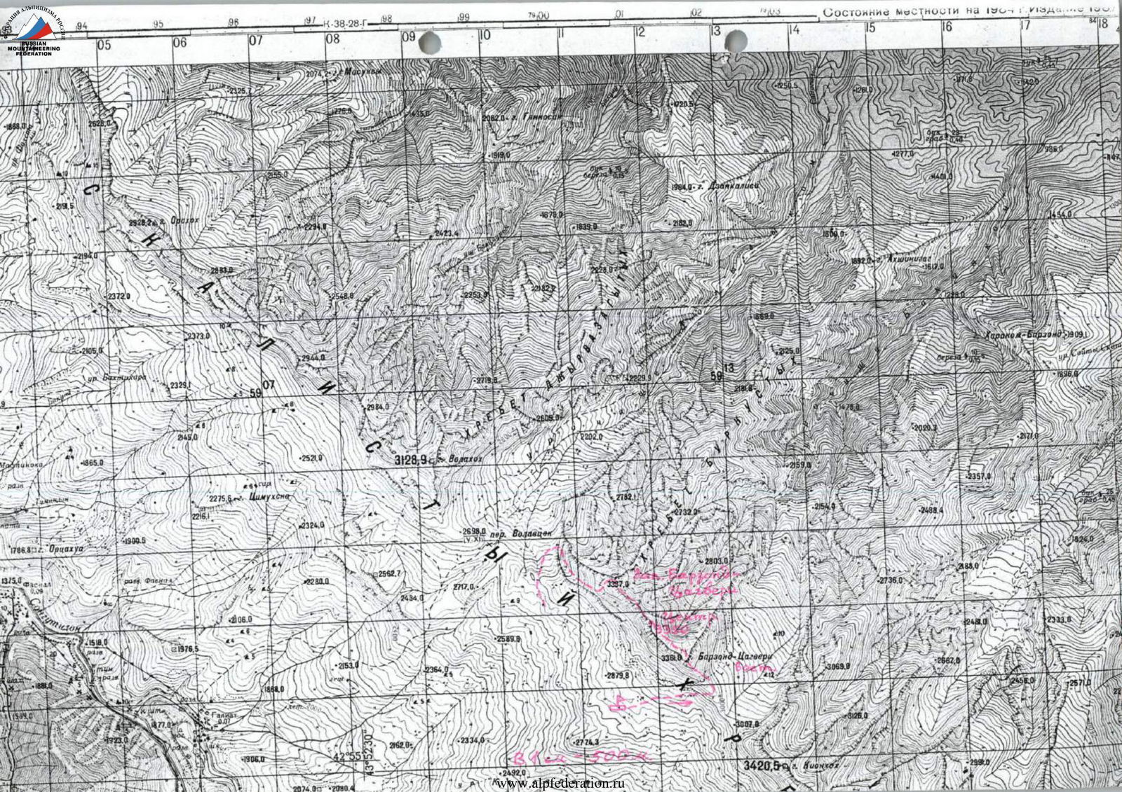
The Kionsky massif is located on the territory of the Republic of North Ossetia – Alania in the Rocky ridge between the Ardon River to the east and the Urukh River to the west. In its western and eastern parts, the main ridge of the massif reaches heights in the highest peaks from 2700 to 2800 m. The most interesting in sports terms – the central part of the massif (from the Ualaga-khokh peak to the Khovtsek peak) has heights over 3000 m for almost 12 km. The entire massif stretches in a latitudinal direction and has a length of about 30 km. The highest point of the Rocky ridge on this segment – Kion-khokh (3420 m).
From the northern slopes of the massif flow many small rivers related to the Terek River basin; these are the Tsrau-don, Urs-don, Dur-Dur, and many others. The southern slopes are drier. To the south, the Kionsky massif breaks off along its entire multi-kilometer length (especially in the central part of the massif) with destroyed walls having elevation differences in some places up to 400 m. The northern slopes are less difficult; they represent scree slopes with rock outcrops, sometimes quite steep. In some places, these rocks form bastions with elevation differences up to 200 m. Generally, approaches from the north are inconvenient due to the lack of roads and trails in the forests north of the massif. Above 2500–2600 m in the forests, small gorges lead to the main ridge, often ending in rock amphitheaters with extensive walls before reaching it.
The rocks composing the Kionsky massif are of sedimentary origin, these are limestones, dolomites, and in some places marble. Therefore, the ridge of the Rocky ridge is heavily serrated and weathered. Most often, the rock is destroyed and impassable, although sometimes you can find strong rocks convenient for climbing (mainly these are walls not of southern exposure). Due to the high weathering of the rocks on the slopes of the massif, there are many screes. Kion-khokh is translated from Ossetian ("kayon" – "khokh") – slab or loose mountain. In the screes on the slopes, you can often find fossilized mollusk shells.
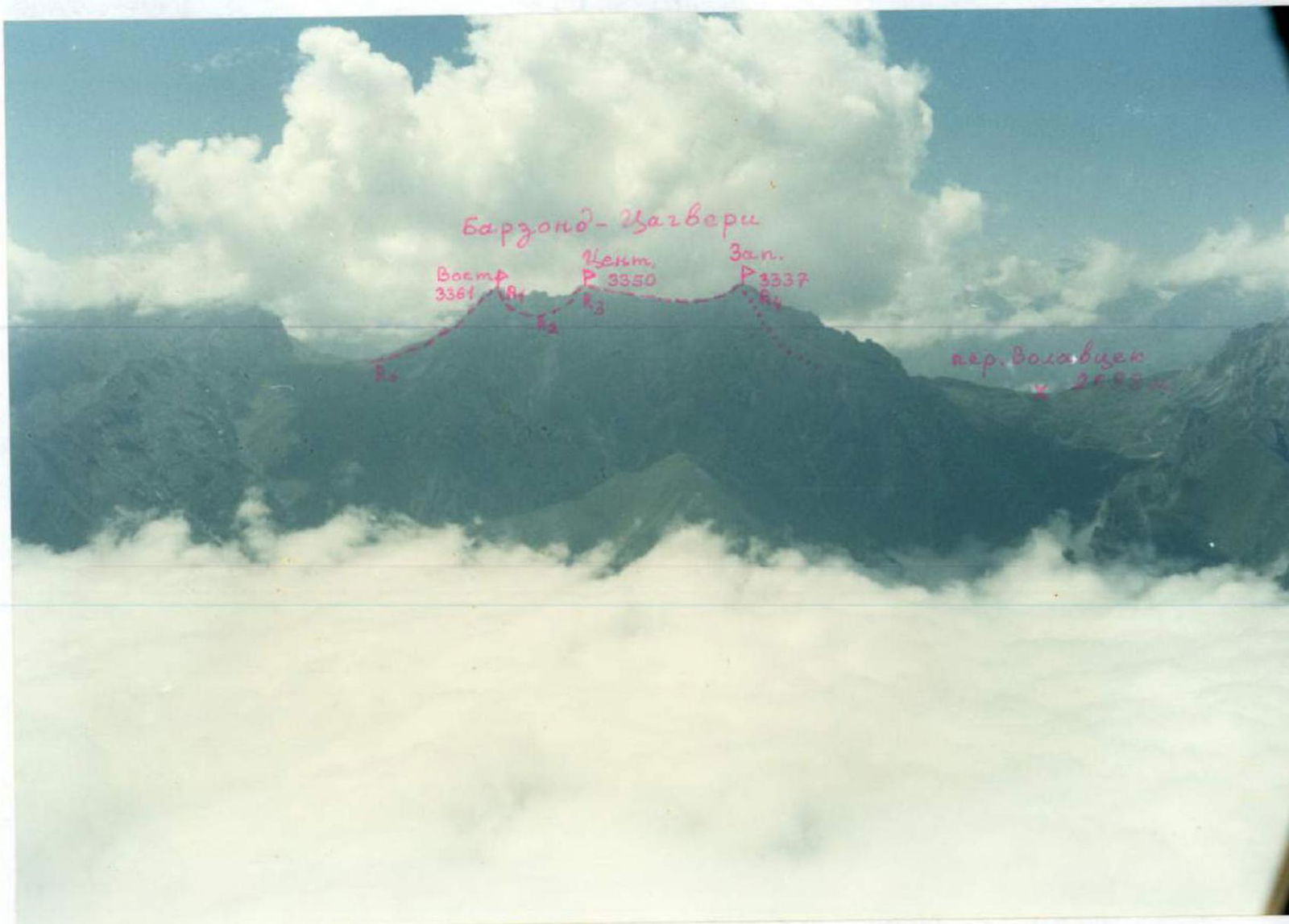
Photopanorama of the area, view from the South. September. Photo from Kazatytseg – Validel Pass between the Sardi dok and Songutidok rivers. The traverse route is marked.
Description of Approaches to the Route
From Vladikavkaz city by bus to Kamunta village 2 h 30 min. From this village, the western part of the Kionsky massif is clearly visible to the south. Against the sky, the heavily serrated ridge of Barzond – Tsagveri stands out; further path goes towards it. From Kamunta village, descend to the river flowing west from Kionsky Pass. From the cattle trail starts an old dirt road leading to Verkhny Zgid settlement. Walk along it for about 1 h, then turn left and start ascending to the south along a grassy slope. The ascent goes in the direction of Barzond – Tsagveri Central peak first along steep grassy slopes and then among huge boulders. After 4–5 h from Kamunta village near some stream – a bivouac (altitude about 2700 m). As a rule, at this altitude from October to May, there is always snow. From the overnight site, the traverse route is clearly visible.
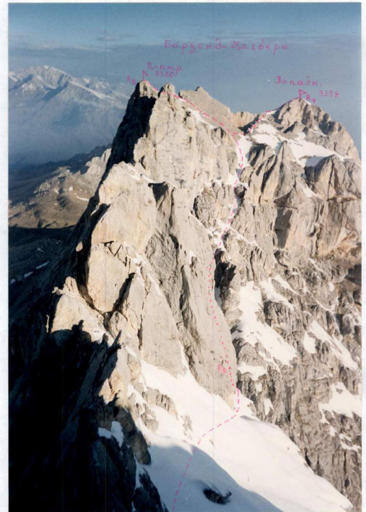
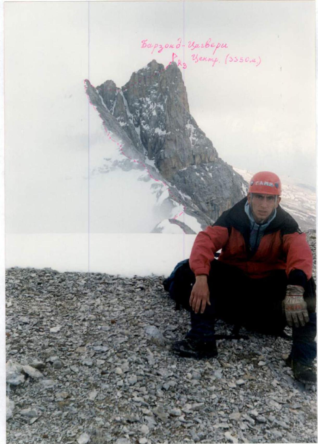
Barzond–Tsagveri
View from the North
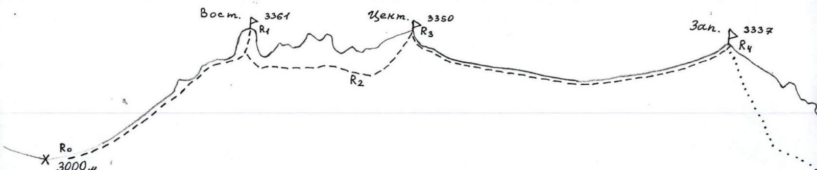
Route Description
From the overnight site, move east under the southern walls of Barzond – Tsagveri to the col between Barzond–Tsagveri East peak – to the left and Kionkhokh peak – to the right. Reaching the col, turn left.
R0–R1: Ascend to Barzond – Tsagveri East peak along the East ridge via route 3A category of difficulty – Yu. Levkovsky's route 1996. This route is officially classified and is in the new Classification (clause 2.8.7).
R1–R2: From the summit tower of Barzond – Tsagveri East, rappel down to the north – about 40 m to a saddle. From the saddle, another rappel to the west – 30 m. Further along the snowy slope, approach under the gendarmes of the ridge leading to Barzond–Tsagveri Central peak. All gendarmes are bypassed on the right along the northern slopes 1–2 category of difficulty (be wary of avalanches with a large amount of snow). The bypass of gendarmes initially goes along the rocks (under the base of the gendarmes), then descend along a snowy gully to the beginning of the traverse along the slabs.
R2–R3: Traverse along snowy slabs – 40 m 2–3 category of difficulty towards a gully leading further up to the ridge, bypassing the remaining gendarmes. Having passed the slabs, ascend along this scree gully 1–2 category of difficulty to the exit to the scree fields of the ridge. Here, turn left and ascend to Barzond – Tsagveri Central peak.
R3–R4: The further path to Barzond – Tsagveri West peak goes along the traverse path of Barzond – Tsagveri (West – Central) 1B category of difficulty (see another report sent simultaneously with this one). The descent from the West peak also occurs to the south with a rappel on the key section of the route 1B category of difficulty. The entire traverse takes about 10 h.
Barzond–Tsagveri East and Central peaks from the Southeast. The ascent route to the East peak along the East ridge, Yu. Levkovsky's route 3A category of difficulty (R0–R1), is marked (visible part).
View from Barzond–Tsagveri East peak to the West. The path bypassing gendarmes on the ridge leading to the Central peak is marked.
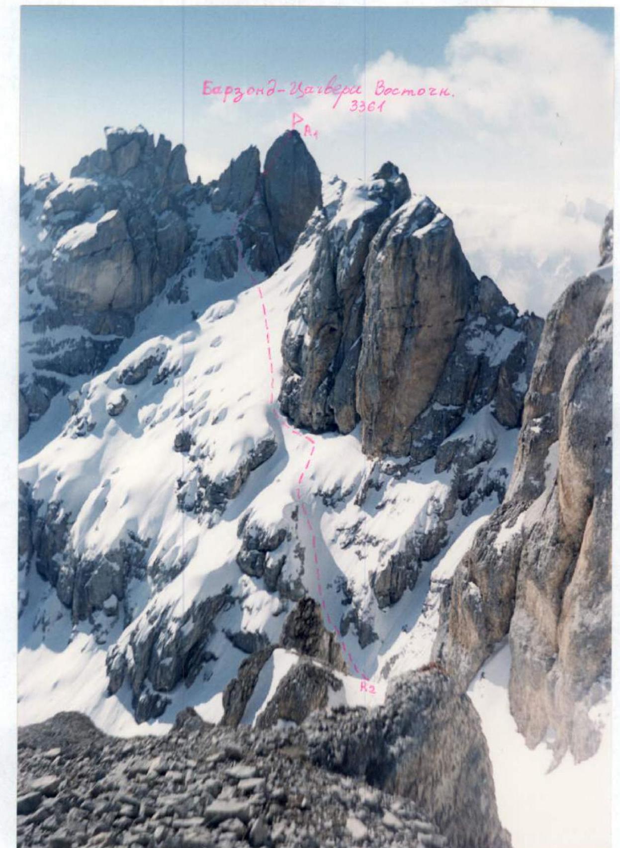
Photo from the middle of the traverse. The East is visible. The descent path from Barzond–Tsagveri East peak with further bypass of gendarmes on the Barzond–Tsagveri East – Barzond–Tsagveri Central ridge is visible.
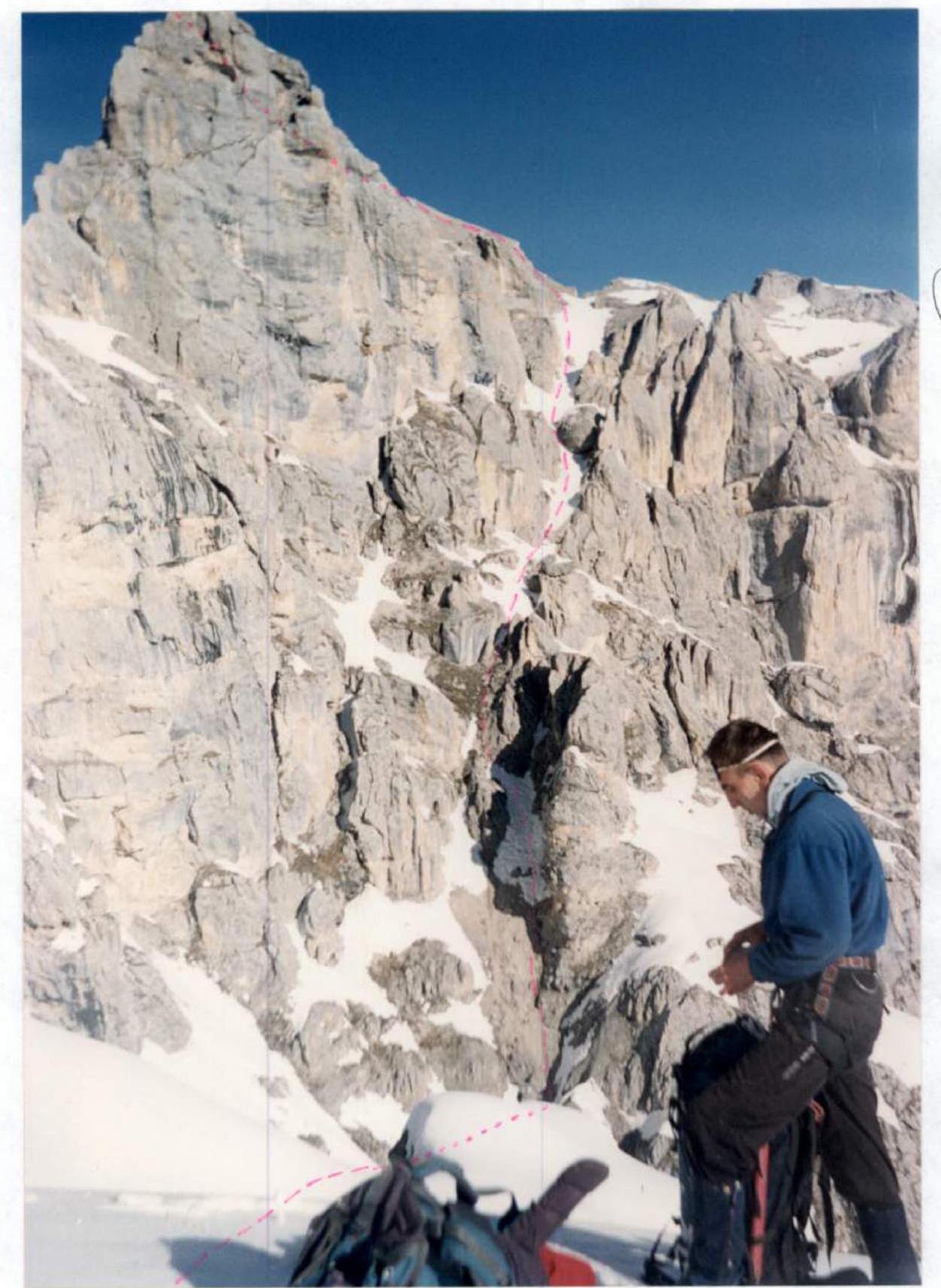
Bypass along the northern slopes of gendarmes on the Barzond–Tsagveri East – Central traverse. Section R2–R3.
View from Barzond–Tsagveri West peak to the East. The traverse path from the Central peak to the West peak is marked. Section R3–R4.
Route Recommendations
The route can be undertaken at almost any time of the year, even in winter, since the ascent to the ridge is from the south, and on the southern walls of the Rocky ridge, the snow melts very quickly even after prolonged snowfalls. Generally, the climate on the southern slopes is much drier than on the northern slopes due to the formation of a so-called "rain shadow" zone. South of the Rocky ridge are the Sunny valleys, and the annual precipitation there is almost half that on the plain – in Vladikavkaz or Alagir.
Therefore:
- The route is safe from the south in terms of avalanches.
- On the ridge from the north, snow slab avalanches are possible; therefore, it is necessary to stay as close to the ridge as possible.
- On the descent and ascent along screes, be cautious with large stones.
Additionally:
- On the route and under it (along the approach path), water (or snow) is available only in winter.
- On the northern slopes of the ridge, snow can be found even in the off-season.
Generally, the route is quite interesting in sports terms, as a purely rock route with saturated, pleasant, and quite serious climbing for its category. It can be recommended for both training and sports ascents, especially in winter and in the off-season.
Due to the low altitude of the peak (compared to the Lateral ridge) and to make the route more interesting in sports terms, it can be recommended to classify the peaks of this area within the proposed category of difficulty, as well as the peaks of the Western Caucasus: Kardyvach and Tsyndyshokh, i.e., from October 15 to May 15.