pr. 557 and 6 dated 24.12.1985
-
Climbing category — snow-ice.
-
Climbing area, ridge: from Geze-tau pass to Gurdzivceg pass, Main Caucasian Ridge.
-
Peak, its height, ascent route: Geze-tau, 3870 m, via North-Eastern slope.
-
Estimated category of difficulty — 3A.
-
Route characteristics: height difference — 1 km, no sections of 5–6 categories of difficulty, average steepness — 38°.
-
Pitons were not hammered on the route.
-
Number of travel hours — 8 hours.
-
There were no overnight stays on the route.
-
Surname, name, patronymic of the leader, participants, their qualification:
Shakalo Valery Matveevich, Master of Sports of the USSR, Borisov Alexey Leonidovich, 3rd sports category.
-
Team coach — Akritov I.P.
-
Date of departure and return — August 3, 1983.
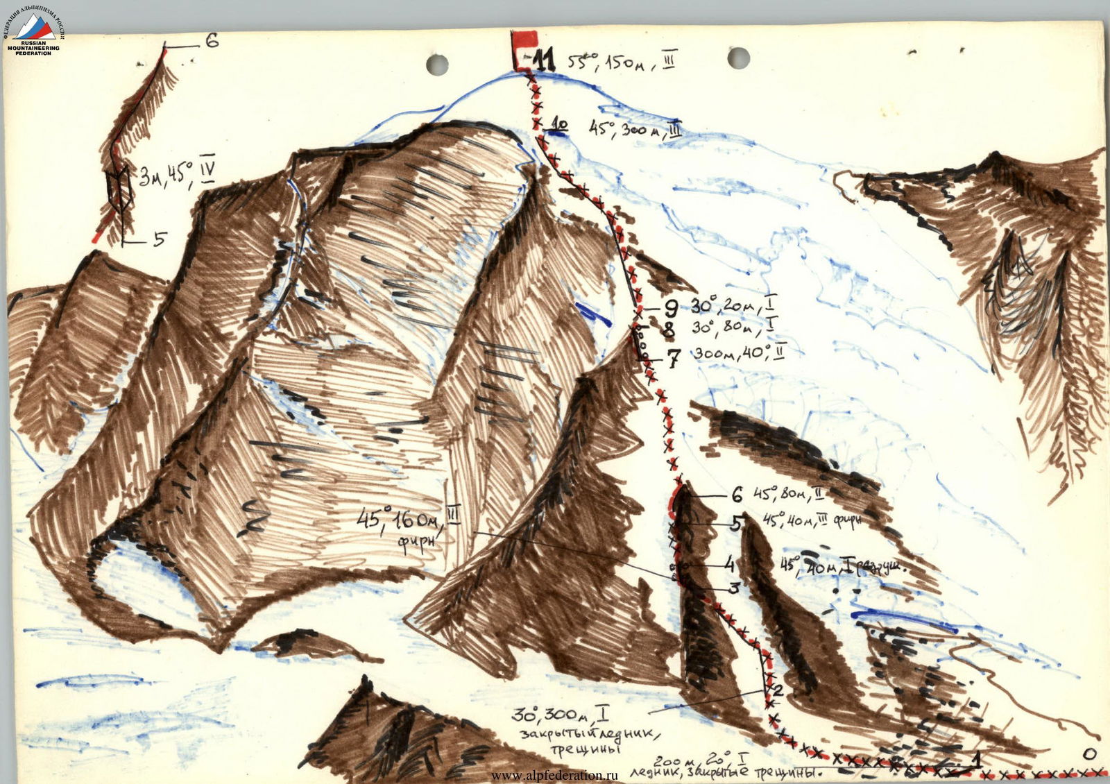
The snow- and ice-covered double-headed nodal peak of the Main Caucasian Ridge, Geze-tau, is located at the junction of the Main Caucasian Ridge and the Shtulsky Ridge, which connects the Main Caucasian Ridge and the Sugansky Ridge. To the south, into Georgia, a powerful spur extends from the peak with the Edena-mta peak. To the northwest, south, southwest, and northeast, between the ridges of the Geze-tau node, powerful glaciers descend: Eastern Shtulu, Edena, Western Zophito, and Mosota. All ridges extending from the Geze-tau peak have passes. On the Geze-tau peak, only one route is laid along the Western Ridge from the Geze-vceg pass, 1A category of difficulty, in 1932 (V. Semenovsky, O. Grinfeld, V. Maslov, etc.). Into the Khares river valley, the Geze-tau massif breaks off with a steep Eastern slate wall, cut through by numerous couloirs, the right orographic edge of which descends to the Mosota pass in the Tsukhbun segment of the Main Caucasian Ridge via the Eastern Ridge. The orographically left part of the Geze-tau peak's wall turns into a steep snow-covered North-Eastern slope, overlapped in its left part by a powerful, difficult-to-pass Nameless Glacier with two icefalls flowing from the Geze-tau peak and the Ptulskaya saddle extending from it to the foot of the peak.
Climbing Geze-tau via the Eastern wall and Western Ridge is problematic due to the destructibility of the rocks. Movement along the Nameless Glacier is also not safe.
The North-Eastern slope of Geze-tau, with an approach via the Mosota Glacier, appears to be the most suitable for climbing from the Khares river gorge. The first ascent of this slope was made on August 3, 1983, by the head of the rescue team of the "Digoria" branch of the "Tsey" alpine camp, Shakalo V.M., and the doctor of the CSP of the Digor region, Borisov A.L., as a duo.
Geze-tau 3870 m
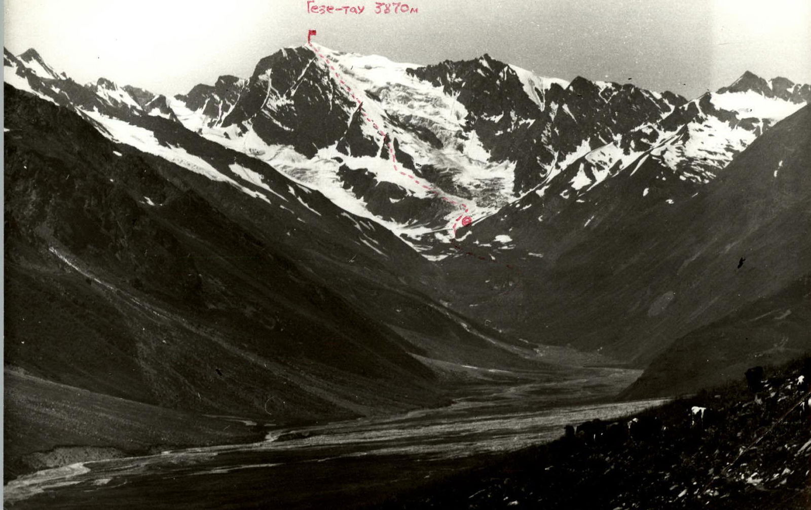
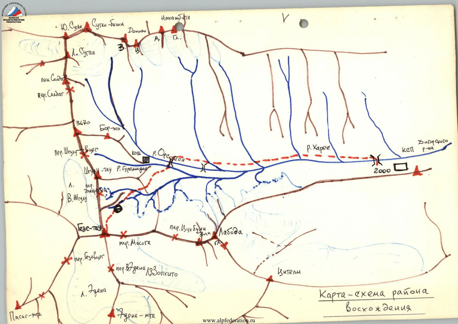
Map-scheme of the ascent area
Description of the approach to Geze-tau peak for ascent via North-Eastern slope
From the CSP of the Digor region along the right bank of the Khares river, first on the road, then behind the waterfall, on the trail, through the Ors-don river to the last koshe located at the fork of the gorges leading to the Mosota Glacier and to the Sugan massif, on the ridge of the Bor-khokh peak, from CSP — 3 hours. Bypassing the ridge on the left, go along the trail along it and the Khares river, cross the Gurami-don river, and further ascend to the grass-covered morainic ridges, which will later become exposed.
Along the moraines, sticking to the right side:
- approach the tongue of the Mosota Glacier covered with surface moraine, bypass it on the right;
- ascend to the glacier and go along its right part in the direction of the North-Eastern slope of Geze-tau peak, until reaching the glacier free from moraine (crevasses!);
- here, turn right and along the right part of the glacier, approach the end of the left orographic green moraine of the Nameless Glacier descending along the North-Eastern slope of Geze-tau peak.
On the moraine — a bivouac.
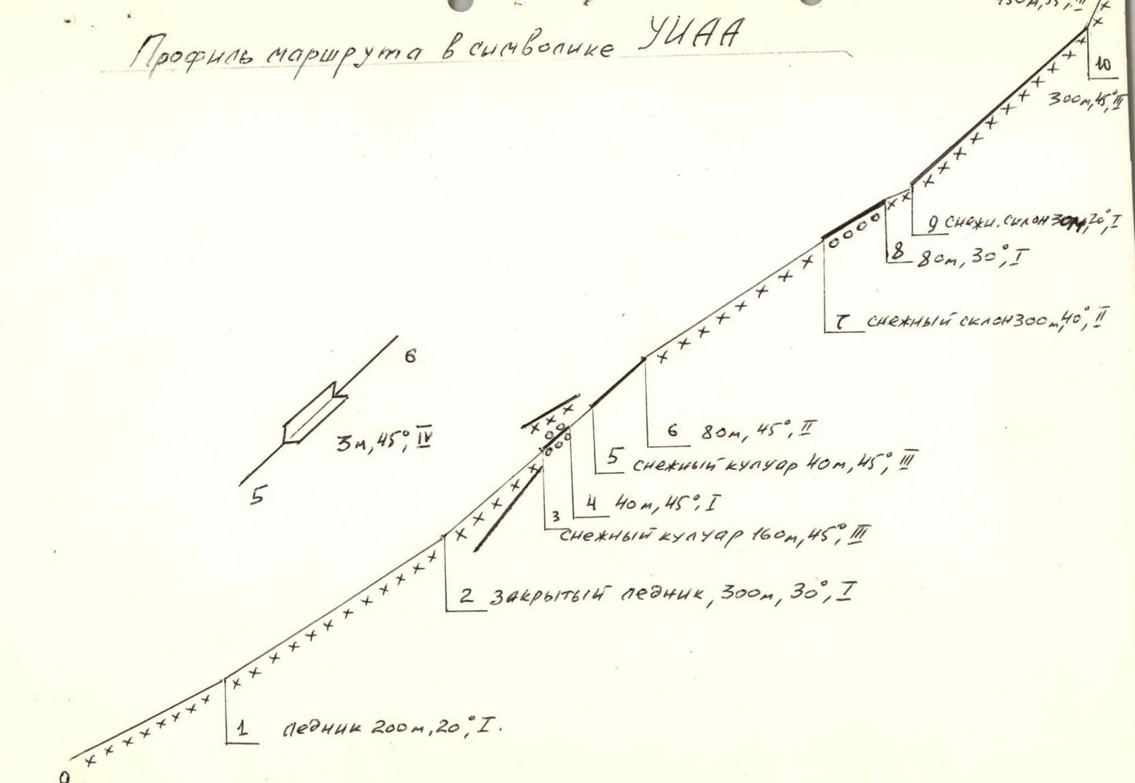
Table of main characteristics of the ascent route
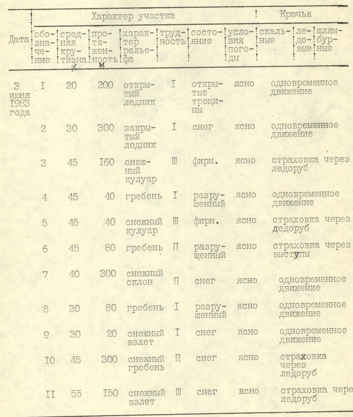
| № | Average steepness | Length | Terrain character | Category of difficulty of the section | Condition | Weather conditions | Notes |
|---|---|---|---|---|---|---|---|
| R1 | 20° | 200 m | Open glacier | 1 | Open crevasses | Clear | Simultaneous movement |
| R2 | 30° | 300 m | Closed glacier | 1 | Snow | Clear | Simultaneous movement |
| R3 | 45° | 160 m | Snow couloir | 3 | Firn | Clear | Insurance through ice axe |
| R4 | 45° | 40 m | Ridge | 1 | Destroyed | Clear | Simultaneous movement |
| R5 | 45° | 40 m | Snow couloir | 3 | Firn | Clear | Insurance through ice axe |
| R6 | 45° | 80 m | Ridge | 2 | Destroyed | Clear | Insurance through ledges |
| R7 | 40° | 300 m | Snow slope | 2 | Snow | Clear | Simultaneous movement |
| R8 | 30° | 80 m | Ridge | 1 | Destroyed | Clear | Simultaneous movement |
| R9 | 30° | 20 m | Snow ascent | 1 | Snow | Clear | Simultaneous movement |
| R10 | 45° | 300 m | Snow ridge | 2 | Snow | Clear | Insurance through ice axe |
| R11 | 55° | 150 m | Snow ascent | 3 | Snow | Clear | Insurance through ice axe |
Brief explanation of the table
From the initial bivouac on the right moraine of the Nameless Glacier descending from the northern ridge of Geze-tau peak, descend to the glacier. Two options are possible here. The first option (safer).
Along the glacier, pass under the rocky belt, then along the steep ice-snow slope with bergschrunds (crevasses!) bypass it on the left, then traverse the ice-snow slope above the rocky belt to the right until the last right snow couloir, to the left of the icefall. The second option (taken by the group).
Along the gentle part of the glacier, ascend to the left upwards in the direction of the lower icefall of the Nameless Glacier (section R0–R1, crevasses!). Then turn left and traverse the ice-snow slope above the rocky belt under the icefall, closer to the rocky belt, in the direction of the first snow couloir (closed crevasses, possible icefall, pass early in the morning).
Along the steep couloir, ascend, crossing it from right to left, to the snow saddle in the rocky ridge. Further:
- Along simple destroyed rocks on the right side of the ridge, approach under the rocky ascent (slopes are difficult, destroyed),
- Bypass the ascent on the left along the snow couloir to the lowering in the ridge,
- Again, ascend to the ridge along simple destroyed rocks of the 3rd wall,
- Move further up along the ridge along simple, destroyed rocks, with a meter inner corner at the beginning, to the talus-covered saddle (a bivouac can be organized here).
From the saddle:
- To the left — upwards along the snow slope until exiting to the flattening part of the first left powerful rocky rib,
- Along simple destroyed rocks of the rib (a bivouac is possible at the end of the rib),
- Through a 20-meter snow ascent, exit to the wide snow ridge leading to the pre-summit ascent,
- Along the steep snow ascent, exit to the Geze-tau peak.
From overnight stays to the peak — 8 hours. Descent along the ascent route takes 4 hours.
Route profile in UIAA symbolism