Galdor Centralny, 3980 m, via the South Buttress Wall, Caucasus, Sugan Range. Strebeyev V.N., August 18, 1995
Passport
1). Technical category 2). Caucasus, Digoria, Sugan Range 3). Galdor Centralny via the S buttress wall (3980) 4). Proposed — 3B cat. diff. combined 5). Height difference 1100 m, length 1300 m, section lengths:
- 3A — 3B cat. diff. — 90 m (buttress),
- 4A cat. diff. — 30 m (inner corner, "Rusty Wall"). Average slope of the main part of the route (base of the buttress — summit) 55°. 6). Pitons left on the route — 2 pcs. not removed (key wall). 7). Team's climbing hours: ascent 8 h (from bivouacs), descent 3 h (via E ridge, 3A cat. diff.). 8). Bivouacs — one in the talus cirque under the Galdor massif (Galdor bivouacs). 9). Leader: Strebeyev V.N., 1st sports category. Dubinsky M.E., II sports category. Kovalenko E.A., II sports category. Plavskaya N.N., II sports category. 10). Approach to the route — August 17, 1995 summit — August 18, 1995, return — August 19, 1995 11). Organization — "Digoria" alpine base.
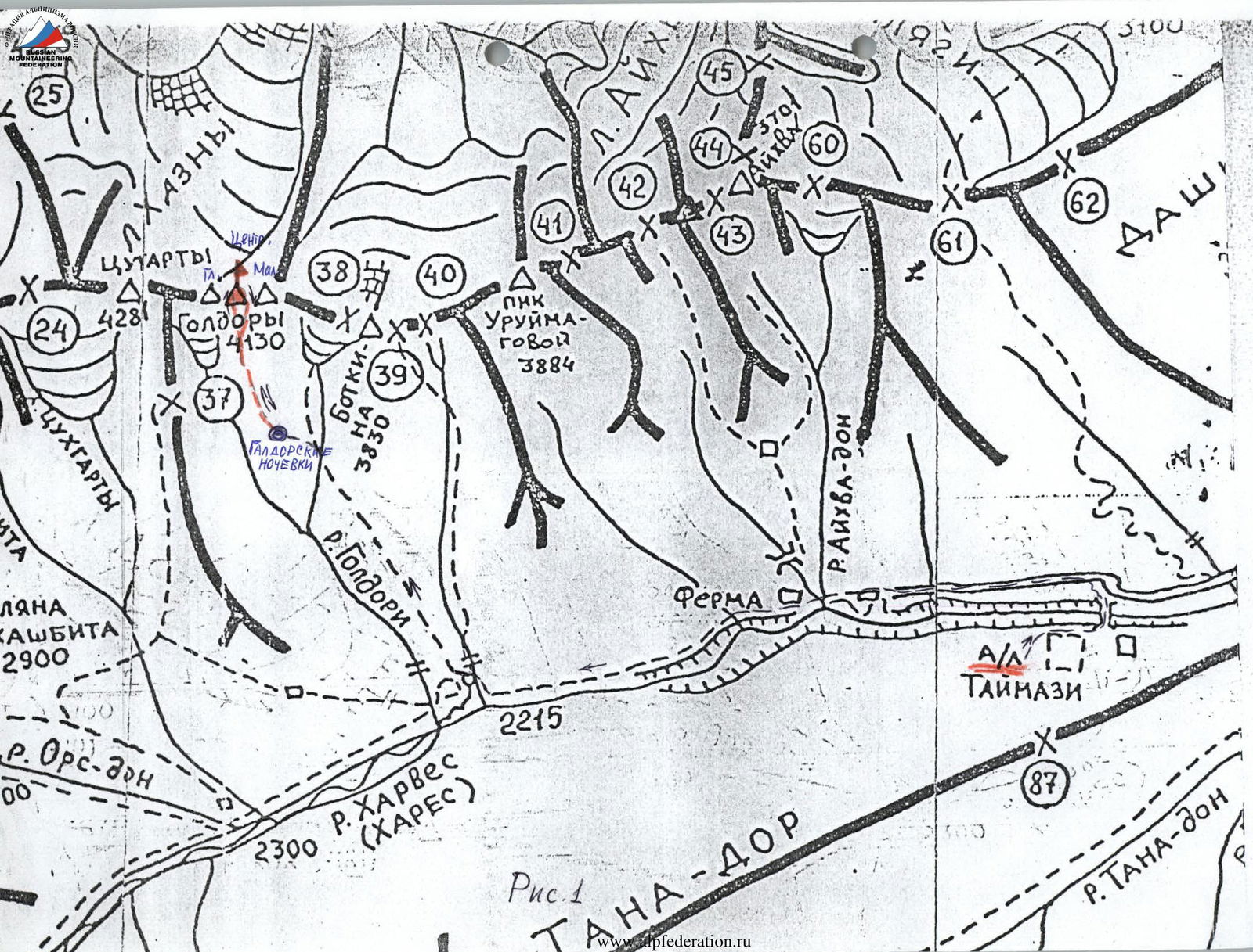
Fig. 1
Description of the route to the summit of Galdor Centralny via the South Buttress Wall, 3B cat. diff.
The summit of Galdor Centralny is part of the Galdor rock massif (4130 m), located in the eastern part of the Sugan Range between Mt. Tsukhgarty to the west and Botkin Peak to the east. Galdor Centralny (3980 m) is the middle tower of the Galdor massif, situated between Galdor Main (4130 m) to the west and Galdor Maly (3700 m) to the east (Fig. 1). From the "Digoria" alpine base, move up the road, and then along the trail laid out on the grassy and talus slopes of the right bank of the Khares River. In 2–2.5 hours, the trail leads to a large clearing with large stones along the left edge, intersected by a stream flowing from the Galdor Glacier. From here, the trail turns steeply upwards along the right side of the stream on grassy slopes to the talus cirque under the Galdor massif. Here, on the clearing located on the boundary between grass and talus, is a bivouac — Galdor bivouacs, 4.5–5 hours from the "Digoria" alpine base. From the bivouac located at Galdor bivouacs, ascend directly upwards through large, medium, and then small talus to the base of a wide couloir descending from the saddle between Centralny and Maly Galdor (1 hour). Here begins the route. Enter the couloir, ascend along its right side, first on talus, then on a snowpatch to the middle part of the couloir, exit it and move 200–250 m upwards on talus ledges and "ram's foreheads" on its right side, ascend to the level when the base of the lower part of the S buttress of Galdor Centralny is opposite. From here, cross the couloir along a steep 40°–45° ice-snow slope in the direction to the right — upwards 60 m (possible rockfall — belay) and approach the rocks of the lower part of the S buttress, to the beginning of a characteristic inner corner leading onto the buttress. Along a steep, moderately difficult inner corner 15 m, ascend onto the buttress and along a simple 25 m ledge, transfer to its left side. Moving along the left side of the buttress, under the overhanging rocks of its right side, approach a steep wall with good holds 15 m, which is overcome directly. Then along a talus ledge 20 m, exit under a 20-meter inner corner with an overhang (1 m) in the lower part, icy and wet on the right side. The inner corner is climbed with piton belay directly on the route, upon exiting the corner along a 15 m ledge to the right (here is an important orientation point, as there is also a convenient ledge to the left under the difficult rocks of the wall), then ascent along a 10-meter corner with an exit onto a talus shoulder of the buttress. Here, a bivouac is possible. From the talus shoulder of the buttress, to the left — upwards 25 m along simple monolithic rocks of the S wall of the buttress, then along a 15-meter chimney of moderate difficulty, approach a steep, above moderate difficulty, monolithic inner corner 15 m. Ascent directly — upwards with piton belay along the inner corner, then to the left — upwards along a simple talus ledge 10 m and upwards along a 15-meter chimney of moderate difficulty with monolithic large holds onto a small platform opposite the upper part of the key "rusty" wall. The summit of Centralny Galdor consists of three sharp towers, and this platform, where three people can gather, is located under the difficult rocks of the middle summit tower. Crossing a narrow rock couloir with a stone plug, exit onto a horizontal ledge — a chip of the "rusty" key wall, which is formed by the rocks of the left summit tower. The key wall is climbed by climbing above moderate difficulty, to the left — upwards 10 m along the chip with a vertical step. At the top of the step — a control cairn. Further along the step of the chip beyond the bend of the wall edge. From here, to the right — upwards along a wall above moderate difficulty 5 m onto a simple, strongly destroyed 30 m ridge of the left summit tower. From the left summit tower along a simple destroyed ridge 60 m onto the middle summit tower, then 10 m sporty descent along a smooth slab under the right, highest tower, on which the summit cairn is located. Ascent 30 m onto the summit tower along rocks with good holds. From the initial bivouac 8–9 hours. Descent from the summit tower by rappel 30 m along the E ridge via the route 3A cat. diff. with an exit onto the saddle of the ridge between Galdor Centralny and Galdor Maly. Further down the ascent couloir, descent to Galdor bivouacs.
Table of main characteristics of the ascent route sections
| Section № | Slope, deg. | Length, m | Terrain character | Category of difficulty | Belay |
|---|---|---|---|---|---|
| R0 | 30 | 700 | talus, snowpatch | 1 | simultaneous with ice axe |
| R0–R1 | 30–35 | 200 | destroyed rocks, talus | 1 | simultaneous for outcrops |
| R1–R2 | 40 | 60 | snow-ice slope | 2 | ice screws |
| R2–R3 | 65 | 15 | inner corner of the rock base of the buttress | 3 | pitons, nuts |
| R3–R4 | 15 | 25 | talus ledge | 1 | for outcrops |
| R4–R5 | 80 | 15 | rock wall | 3 | pitons |
| R5–R6 | 15 | 20 | talus ledge | 1 | for outcrops |
| R6–R7 | 70 | 20 | wet inner corner | 3 | pitons, nuts |
| R7–R8 | 20 | 15 | rock ledge leading to the shoulder of the buttress | 2 | pitons, outcrops |
| R8–R9 | 45 | 10 | inner corner, exit to the shoulder | 2 | pitons |
| R9–R10 | 50 | 25 | monolithic rocks | 2 | nuts |
| R10–R11 | 65 | 15 | chimney | 3 | pitons |
| R11–R12 | 80 | 15 | monolithic inner corner | 4 | pitons, nuts |
| R12–R13 | 65 | 25 | talus ledge, rock chimney, exit to the platform opposite the key wall | 3 | pitons, nuts |
| R13–R14 | 80 | 10 | through the plug of a narrow couloir, exit to the ledge — chip of the key wall | 4 | pitons, necessary extensions with carabiners, ropes |
| R14–R15 | 70 | 5 | wall behind the bend of the key wall | 4 | pitons, ropes |
| R15–R16 | 30 | 30 | destroyed ridge | 2 | for outcrops |
| R16–R17 | 50 | 100 | destroyed ridge, summit | 2 | pitons, for outcrops |
Safety assessment of the route
The objectively dangerous section on the route is R1–R2 due to the
possibility of rockfall from the upper part of the couloir. This section
is climbed one by one, with observation of the top of the couloir.
The rock part of the route passes mainly through monolithic rocks,
the rockfall hazard from above is minimal, belay stations in almost
all cases can be organized under monolithic rock awnings, protecting
from stonefall by the upper participant. The route is laid out so that
there is no need for the upper participant to work directly above the lower ones.
At the level of R9, on the shoulder of the buttress, there is a good platform
for a tent, a bivouac is possible. If necessary, from this place,
it is possible to rappel into the ascent couloir and leave the route.
On the key wall, it is necessary to use extensions due to rope bends
when exiting onto the wall from the narrow couloir and when turning
behind the bend of the key "rusty" wall.
The route can be recommended for passage by teams of level SP-2,
having rock climbing training.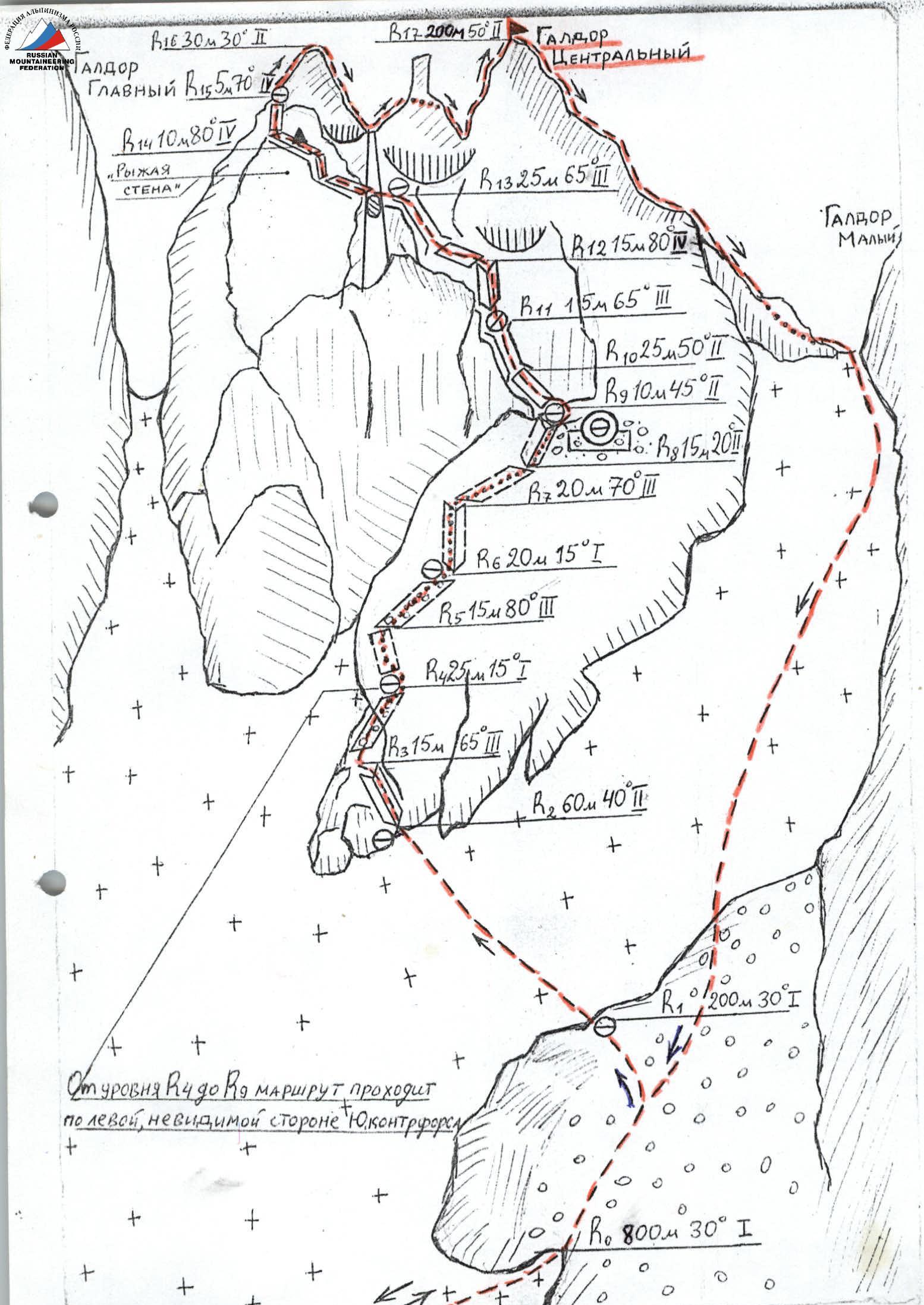
Route scheme
 Route photo №1
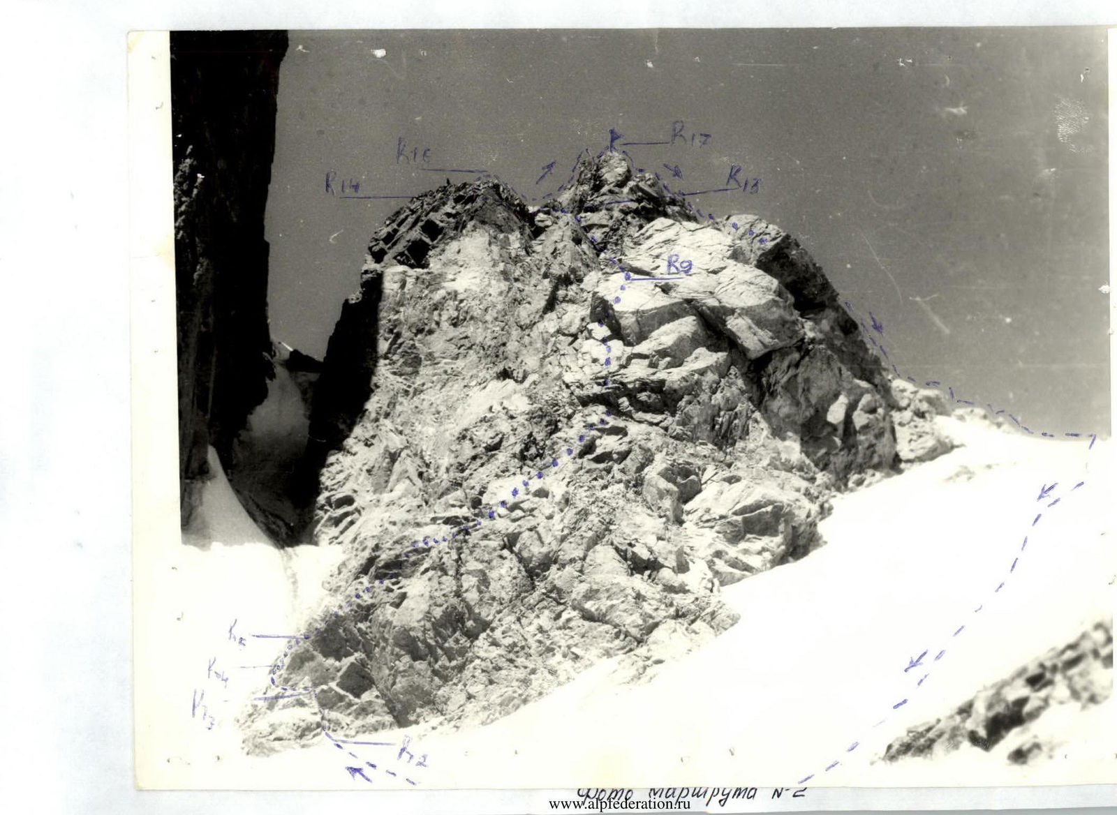 Route photo №2
INSTRUCTOR
(STREBEZHEV V.N.)
Route photo №2
INSTRUCTOR
(STREBEZHEV V.N.)