- Caucasus, Sugansky Ridge, Classification section number — 2.6.
- Galdor Glavny (4239 m); via the South Face.
- Proposed category — 5A; first ascent.
- Route character — rock.
- Route elevation gain — 420 m (by GPS).
Route length — 550 m. Steepness of key sections — up to 90°. Length of sections with 5th category difficulty — 5 m.
- Hooks left on the route — 1.
Used on the route:
- rock hooks — 15;
- chocks — 25.
- Climbing hours — 8; days — 2 (including acclimatization).
- Team leader: Egorin S.V. — Master of Sports.
Team members: Zhirnov D.N. — 1st sports category.
- Coach: Egorin S.V.
- Departure for the route (acclimatization) — 15:00; August 6, 2005.
Summit attempt — 12:00; August 7, 2005.
- Organizing body: North Ossetian Rescue Service of the Ministry of Emergency Situations of Russia.
Brief Overview of the Climbing Area
The Galdor massif is located in the center of the Sugansky Ridge. The southern slopes of the Sugansky Ridge are situated within the territory of the Republic of North Ossetia-Alania. The northern slopes are located within the Kabardino-Balkar Republic. The Sugansky Ridge is situated between the basins of the Cherek-Balkarsky River to the West and the Urukh River to the East. Numerous rivers flow from its slopes:
- Rtsivashki,
- Psygansu,
- Khaznydon,
- Belyagidon,
- Karasu,
- Khares.
The Sugansky Ridge stretches for almost forty kilometers in the latitudinal direction. It reaches an average height of 3800 m. Its highest peaks, reaching about 4500 m, rise 1000 m above the snow line. All its passes, even the lowest and relatively accessible ones, are located above 3300 m, and in the central part of the massif — above 3700 m.
The Sugansky Ridge is composed of ancient rocks: light-gray granites of the Paleozoic era and dense, heavily metamorphosed clay shales of the Lower Mesozoic.
The ridge has an asymmetric structure of its slopes:
- steep and short on the South,
- gentle and long on the North.
The southern slopes of the ridge are dissected by numerous destroyed ridges and counterforts, between which lie steep, heavily broken, short hanging glaciers; below them are numerous scree slopes.
The southern slopes of the ridge are well-developed by climbers, who have established dozens of routes here with difficulties ranging from 1B to 5B.
The northern slopes are characterized by:
- extensive glaciation,
- rare rock ridges,
- greater elevation gain compared to the South.
Ascents from the North are technically more challenging and harsher in terms of weather conditions. The routes that have been completed typically have fourth and fifth category difficulties, and most remain to be pioneered.
The climate of the area is typical for the Caucasus, characterized as mountainous, cold, with high humidity (1500–1600 mm of precipitation per year).
Summer in the mountains (July–August) is short and cold (+14 — +18°C).
Winter lasts from November to March, and in the highlands, frosts can reach −30°C, but relatively little precipitation falls. Most of the precipitation occurs from May to August.
From a height of 3200–3500 m, the climate becomes one of eternal cold, reminiscent in its severity of the Arctic climate:
- the average temperature even of the warmest month does not rise above 0°C,
- cloudy and windy weather prevails,
- a large amount of precipitation, mostly in the form of snow.
By 2005, ascents to Galdor Glavny from the South had been made via the South Ridge, category 4A — 1936 — by A. Alexandrov; and by A. Pogorelov via the Southeast Face in 1983 — category 5B.
Approach to the Route Description
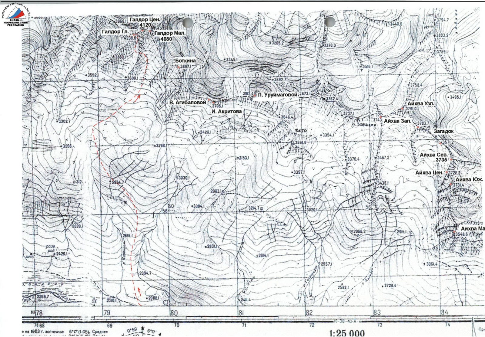
From the S.O.L. "Komy-art" (Digoria alpine camp), cross the Khares River by the bridge, then ascend westward along the road on the right (in the direction of travel) side of the valley. After 1 hour, having passed a waterfall near the road, take a trail among the meadows. Follow this trail to a huge, grass-covered ancient moraine rampart, and taking the upper trail, arrive at the first large stream flowing from the southern slopes of the Sugansky Ridge from under the peaks of Botkin and Uruimagov. The journey from the camp to the stream takes about 2 hours.
After crossing the stream, turn north and begin ascending a steep, wide, grassy ridge between two streams. To the right flows a stream originating from under Botkin-Uruimagov; to the left is the so-called Galdorka River, which originates from the Galdor overnight camps and under the Galdors.
After the first steep ascent, the ridge's steepness decreases somewhat, and it continues with ups and downs. When outcrops of destroyed rocks appear on the slope to the left of the ridge, traverse left under their base with a gradual gain in height.
After some time, having completely left the ridge, enter the Galdorka River valley. Continue ascending along it. The trail eventually leads to the Galdor overnight camps (at an altitude of 3200 m) — the last patches of grass among the morainic boulders. Camp near the last water source (stream).
From the camp:
- approximately 6 hours of travel,
- elevation gain — 1400 m.
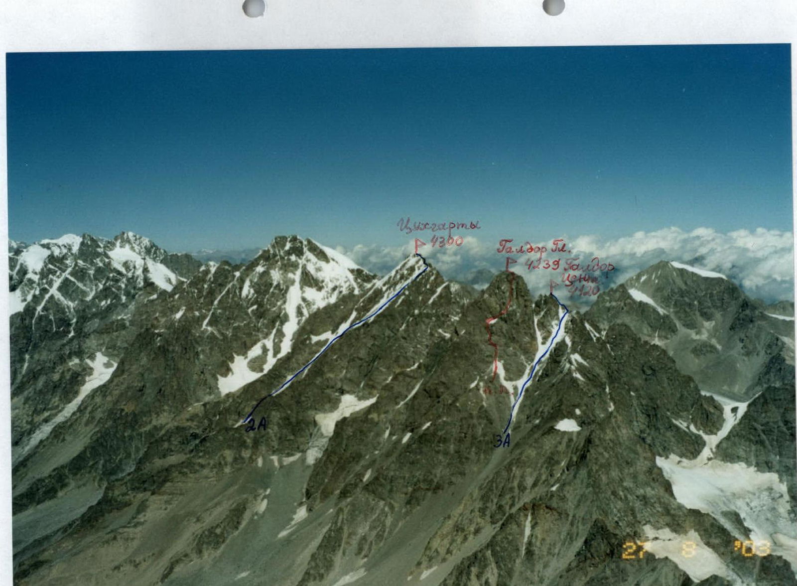
Sugansky Ridge from the Southeast. Photo taken from a helicopter. Classified routes are marked in blue. The first ascent route on Galdor Glavny is marked in red.
Condition as of 1963.
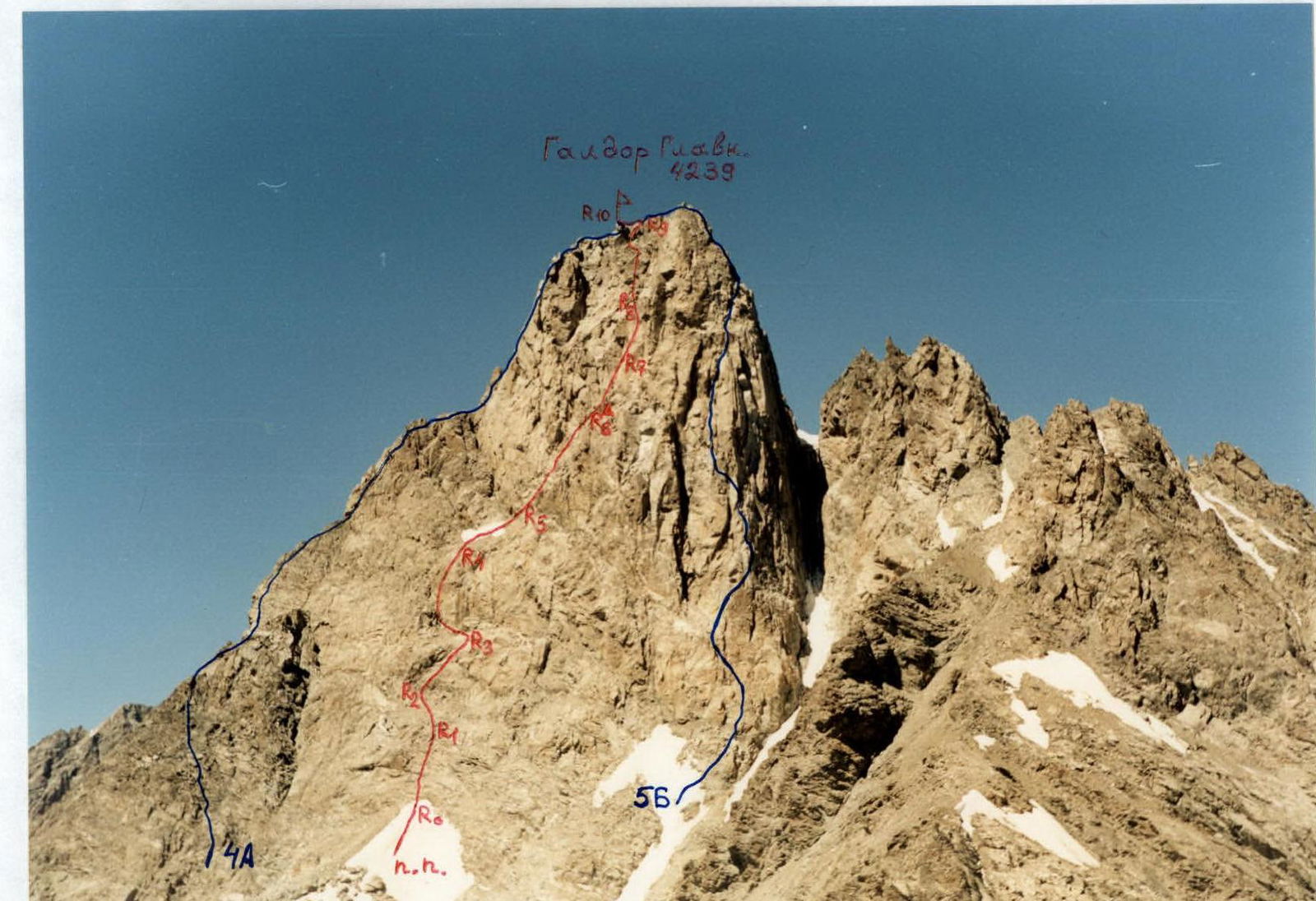
Galdor Glavny from the Southeast, sp. Botkin. August. Classified routes are marked in blue. The first ascent route via the South Face is marked in red.
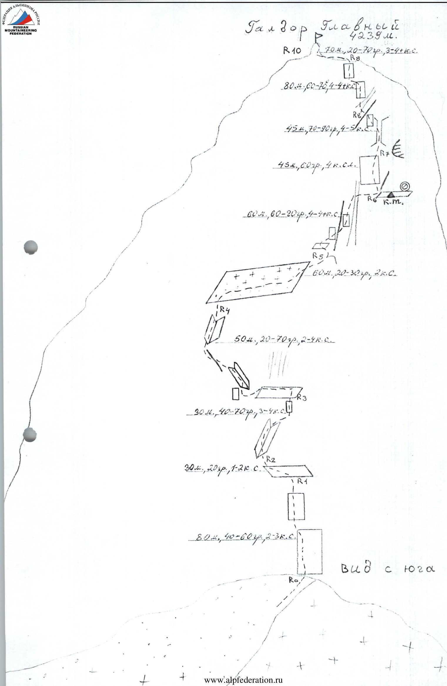
Route Description
From the Galdor overnight camps, ascend to the right towards the base of a large couloir descending southward from the Sugansky Ridge. The couloir is located east of the Galdor Glavny tower. Ascend this couloir, initially over scree, then over remnants of avalanche cones, upwards on its right side towards the South Face of Galdor Glavny. After 2 hours, at the point where the couloir narrows (with rock outcrops to the right), cross to its left side.
Be cautious of potential rockfall from above! Crampons may be necessary if the snow is hard.
About 200 m further, exit the couloir and begin ascending to the left upwards towards a scree shoulder at the base of the South Face of Galdor Glavny. The path goes over destroyed rocks to the left of a snowy slope. The rocks are category 2, and in the upper part, category 3. A rope may be necessary for carrying heavy backpacks.
Continue to the scree shoulder, where a campsite is possible — be careful not to set up too close to the South Face due to potential rockfall! The journey from the Galdor overnight camps takes 4–5 hours. The South Face of Galdor Glavny is visible from the camps. The start of the route is to the left of the snowy slope, from the end of the scree.
Section R0–R1: Ascend the face (in the second half of the day, beware of rockfall from above). After 50 m, traverse left and upwards to reach a scree ledge.
- Entire section is 80 m
- Category 2–3
- 40–60°
Section R1–R2: Along the ledge, approach the rocks, traverse left under them, then cross a stream flowing through an internal corner.
- Section is 30 m
- Category 1–2
- 20°
Section R2–R3: Ascend the left part of the corner, then move to its right side and approach a wall leading to a ledge.
- On the wall, 5 m; 70°; category 4; reach the ledge (beware of rockfall from above)
- Entire section is 30 m; internal corner category 3; 40–50°
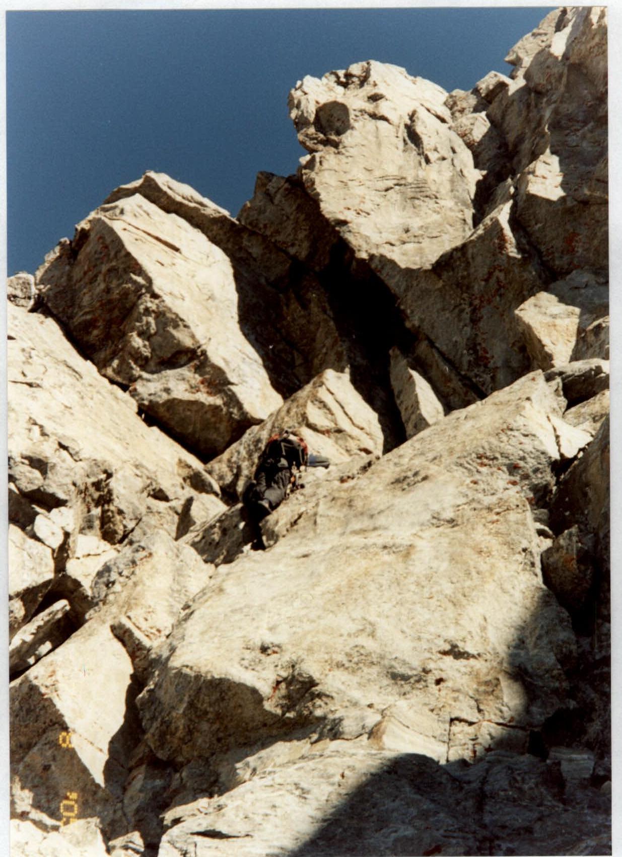
Section R3–R4: Traverse left along the ledge under overhanging rocks with a stream (10 m), approach the left part of an internal corner. Ascend it for 10 m; category 4; 60°, then exit left from the corner onto a ridge — another 10 m; category 3. Continue up an internal corner, category 4; 60–70° for 20 m, then exit onto the left part of a snowy-scree ledge. Entire section is 50 m.
Section R4–R5: Ascend the ledge to the right and upwards, to its right side, onto a small scree shoulder. Ledge — 60 m; category 2; 20–30°. Belay!
Section R5–R6:
- From the shoulder, along the ledge on the left part of the ridge, 10 m;
- then via the wall, exit onto the ridge — another 10 m;
- category 4–4+;
- 70–80°.
After the ridge, move beyond it (further movement is not visible to the lead climber), to the right side of the ridge, category 4, then to the left part of an internal corner — a couloir until it narrows.
Here, cross it to the right under the rocks onto a ledge. The upper part of the corner is 80°, category 4–4+; on the transition, destroyed rocks; potentially a stream or ice on the rocks in the morning. Entire section is 60 m.
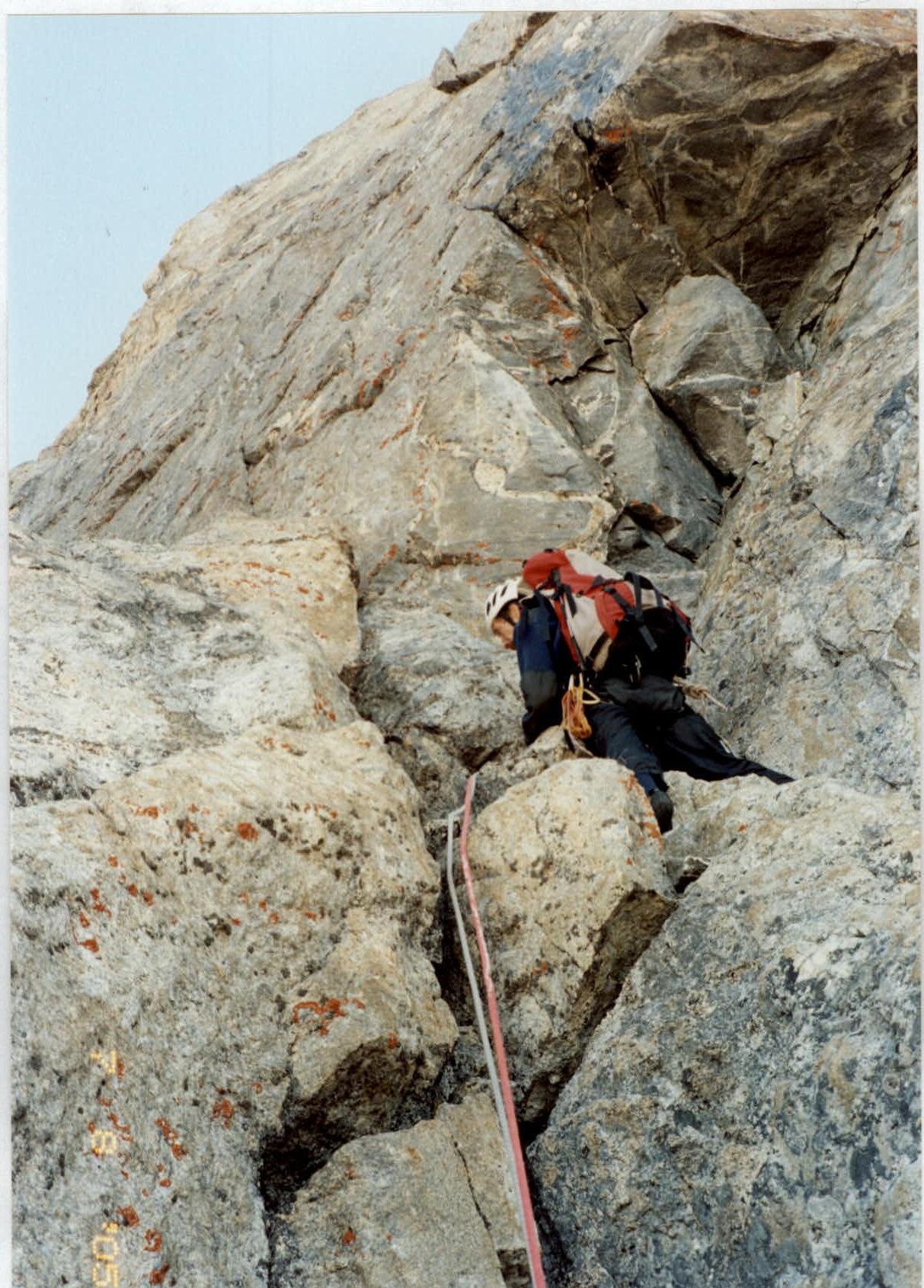
Section R6–R7: Under the rock to the right on the ledge, there's a control cairn in a plastic bottle. Further to the right, beyond the corner, the ledge widens, allowing for a sitting bivouac.
Bypass the rock with the control cairn on the left — and ascend the large-block gray wall upwards — 45 m, category 4, 60°. Reach under a cornice with a black stain.
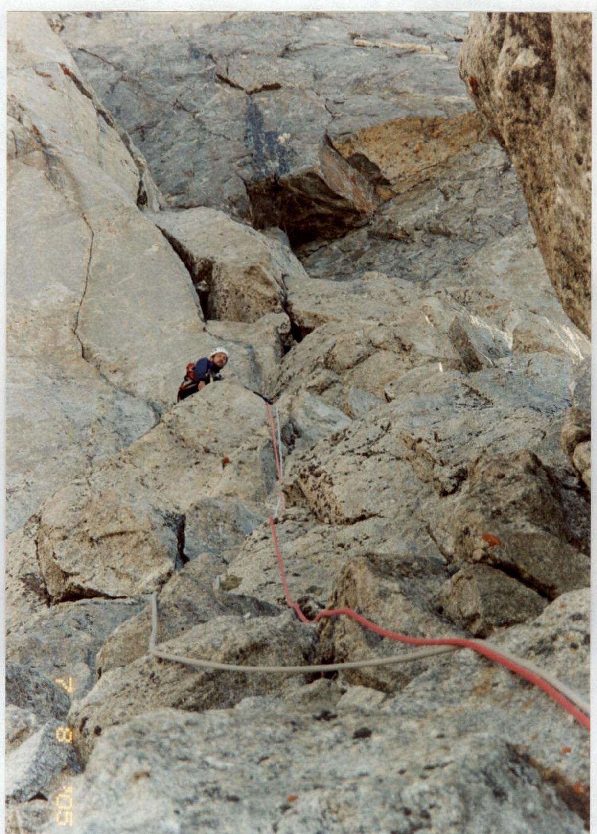
Section R7–R8: Initially through a crack, then via a not-so-pronounced internal corner — a chimney, category 4–4+, to the left of smoothed gray slabs. After 15 m, the climbing partner is out of sight. At the end of the section:
- After 30 m, exit the corner to the left via a wall, 5 m
- Turn 90°
- Ascend 5 to a ridge
- From the ridge, descend to a ledge
Entire section is 45 m.
Section R8–R9: From the ledge behind the ridge, descend slightly, cross a small internal corner, and ascend initially over smoothed slabs, then to the left of them, towards large overhanging blocks visible against the sky.
- Slabs: 60°; category 4
- Chimney to the left of the slabs: 10 m; 70°; category 4+
- From under the overhang, traverse left along a slab: 10 m; category 4; 60°
- After the traverse, turn right and exit onto the ridge via a wall: 20 m; 60°; category 4
Entire section is 80 m.
Section R9–R10: On the ridge, turn left and, bypassing complex sections, along ledges, approach the summit tower. Ridge category 3; 20°, 60 m. Summit exit is 10 m; 70°; up to category 4+. From the start of the route (R0), approximately 8 hours. The summit offers an excellent panoramic viewpoint. Descend via the category 4A route — study its description in detail beforehand.

Passage of the beginning of section R5–R6.
Passage of the middle of section R6–R7.
Passage of the beginning of section R7–R8.
Passage of the middle of section R8–R9.
Conclusions and Recommendations for the Route
The route corresponds to the stated category. It develops skills for working and orienting on a wall route. When deviating from it, one can encounter more complex rocks. The rocks on the route are of a blocky type; it's recommended to have a set of chock stones. Also, for the lead climber — rock shoes. It's advisable to carry spare runner slings for rappelling.
The specificity of the South Face — the high starting point of the route (3800 m). It follows that the tactical plan should be thought out in advance.
On the first day, we reached the Galdor overnight camps from the camp, on the second day to the scree shoulder under the wall, and after lunch, processed the route up to R4. On the third day — an early ascent, the route, the summit, descent, and on the same day, descent to the camp. We descended via the category 4A route to the middle of the route, then from the shoulder of the South Ridge, rappelled to R4, and further along the ascent route.
Up to R4, there are many old slings and hooks. Check them when descending!