
Ascent Passport
-
Digoria, Sugansky ridge, Classification section number 2.6.
-
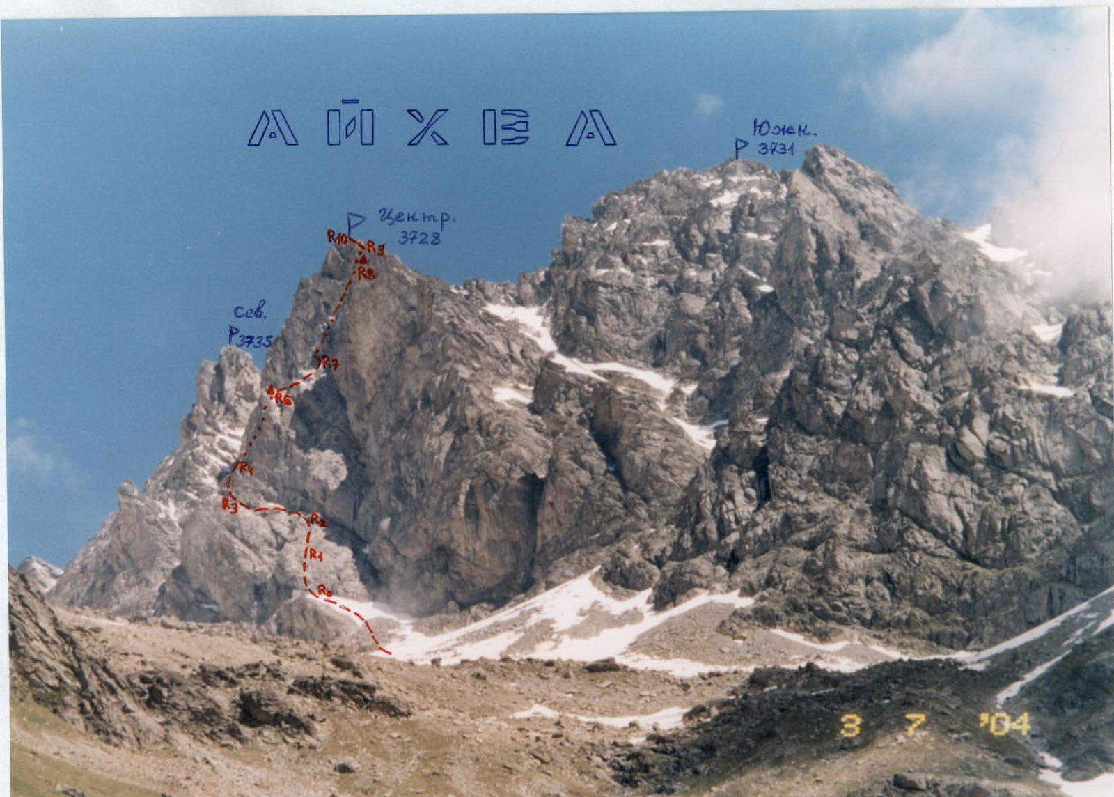
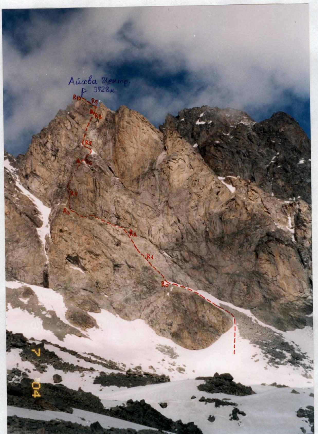
Aikhva Tsentr. (3728 m) – via the Western bastion.
-
Proposed 4A–4B cat. dif., first ascent.
-
Route character — rock.
-
Route height difference – 390 m (from point R0).
Total route length – 560 m. Length of sections:
- 5 cat. dif. – 3 m;
- 4 cat. dif. – 285 m.
Average steepness:
- main part of the bastion route – 65°;
- entire route – 60°.
-
Pitons left on the route: total – 2 pcs.
Total used on the route:
- rock anchors – 12;
- protection gear – 33.
Drill anchors – not used.
-
Team's climbing hours: 8 h; 1 day.
-
Leader: Egorin Sergey Vladimirovich – MS.
Participants: Zhirnov Dmitry Nikolaevich – 2nd sports category. Rodin Alexander Vladimirovich – 2nd sports category.
-
Coach: Egorin Sergey Vladimirovich.
-
Approach to the route: 6:00 July 4, 2004.
Reach the summit: 14:00 July 4, 2004. Return to Base Camp: 19:00 July 4, 2004.
-
Organization: North Ossetian Search and Rescue Team of the Russian Emergency Situations Ministry.

General view of the Aikhva massif from the Khares gorge. View from the southwest. The first ascent route to Aikhva Tsentr is marked.
Brief Overview of the Ascent Area
The ascent was made in the eastern part of the Sugansky ridge, the southern slopes of which are located in the Republic of North Ossetia — Alania.
The Sugansky ridge is composed primarily of magmatic rocks — granites and diorites.
In the eastern part of the Sugansky ridge, on its southern slopes, glaciation is weakly expressed compared to the western part of the ridge, as the heights of the peaks in the area drop below 4000 m.
In the cirques, numerous snowfields or remnants of once larger glaciers can be found. Everywhere, signs of their activity are visible — scree, moraine ridges, and "ram's foreheads." Above 3000 m, the southern slopes, especially the couloirs and cirques, are covered with numerous scree fields, which are already starting to be overgrown with advancing vegetation.
The heights of the peaks after Galdor Glavny and further east nowhere reach 4 km again. The average height of the peaks here is 3700–3800 m. The Sugansky ridge has a mainly latitudinal direction and stretches for about 8 km from Pik Botkina to Dashikhoh. Its main spurs in this area are the Belagsky ridge, branching off to the north from Aikhva Uzlovaya, and the Aikhva spur, branching off to the south from Aikhva Severная.
The eastern part of the Sugansky ridge was rarely visited by climbers. However, starting from 2000, ascents began to be made more frequently. Many new routes were climbed, and the exploration of the peaks in this area began.
Ascents in this part of the Sugansky ridge are optimal in the first half of summer — the snow melts quickly here, and the approaches and routes are mostly south-facing. For visiting the peaks in this area, border guards do not require a permit, and the close proximity to the alpine camp is also convenient. To date, routes from 1 to 4 cat. dif. have been climbed in the eastern part of the Sugansky ridge — and all from the south. From the north, no ascents have been made yet (long approaches).
The climate in the area is, as everywhere in the Caucasus, characterized by frequent thunderstorms and downpours in summer, but it is drier than on the Main Caucasian ridge. This is evident from the sparse forests on the southern slopes of the Sugansky ridge.

Photopanorama of the area. Aikhva massif from the west. Photo taken from a helicopter. The first ascent route to Aikhva Tsentr via the Western bastion is marked.
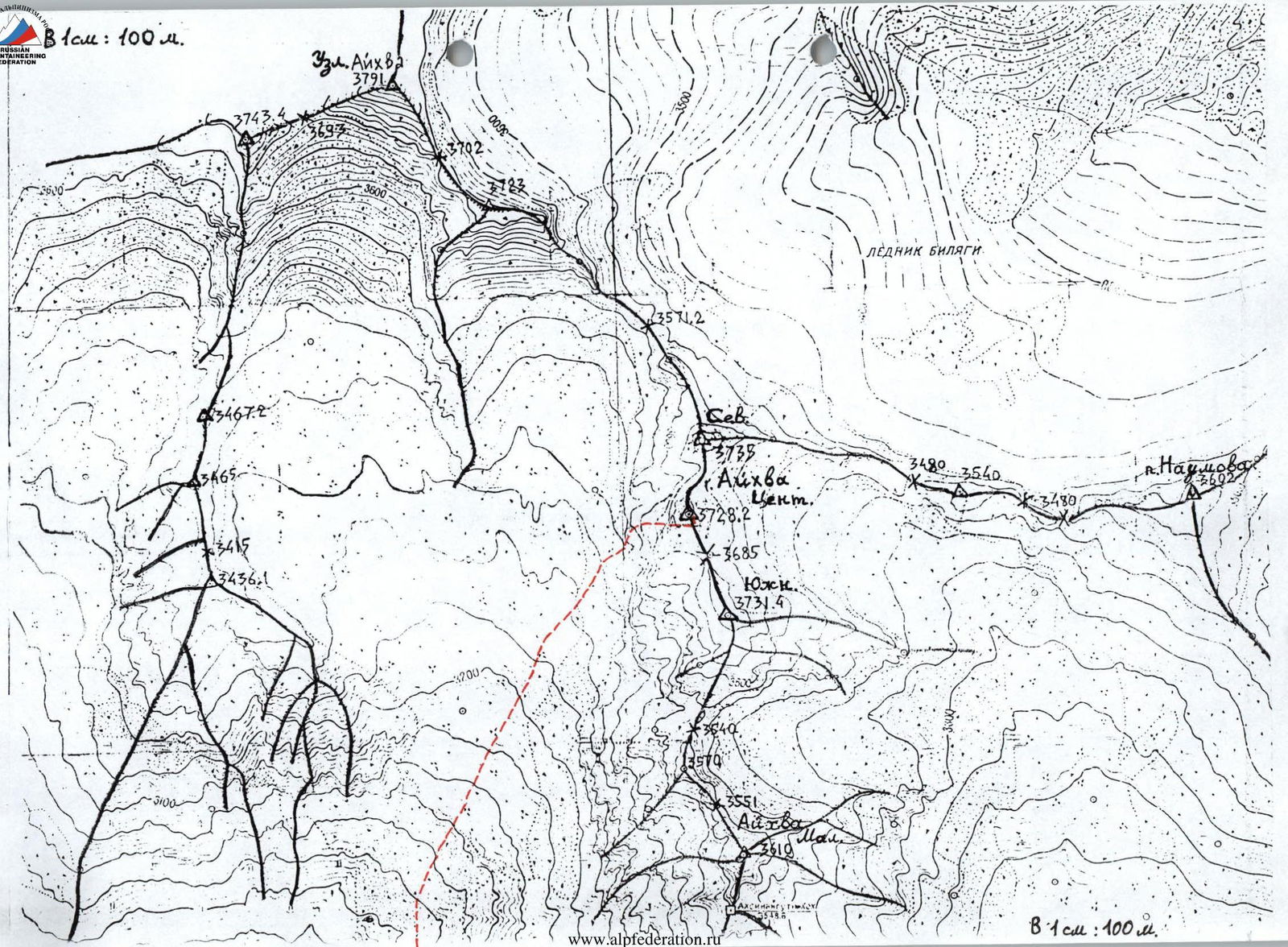 1 cm: 100 m.
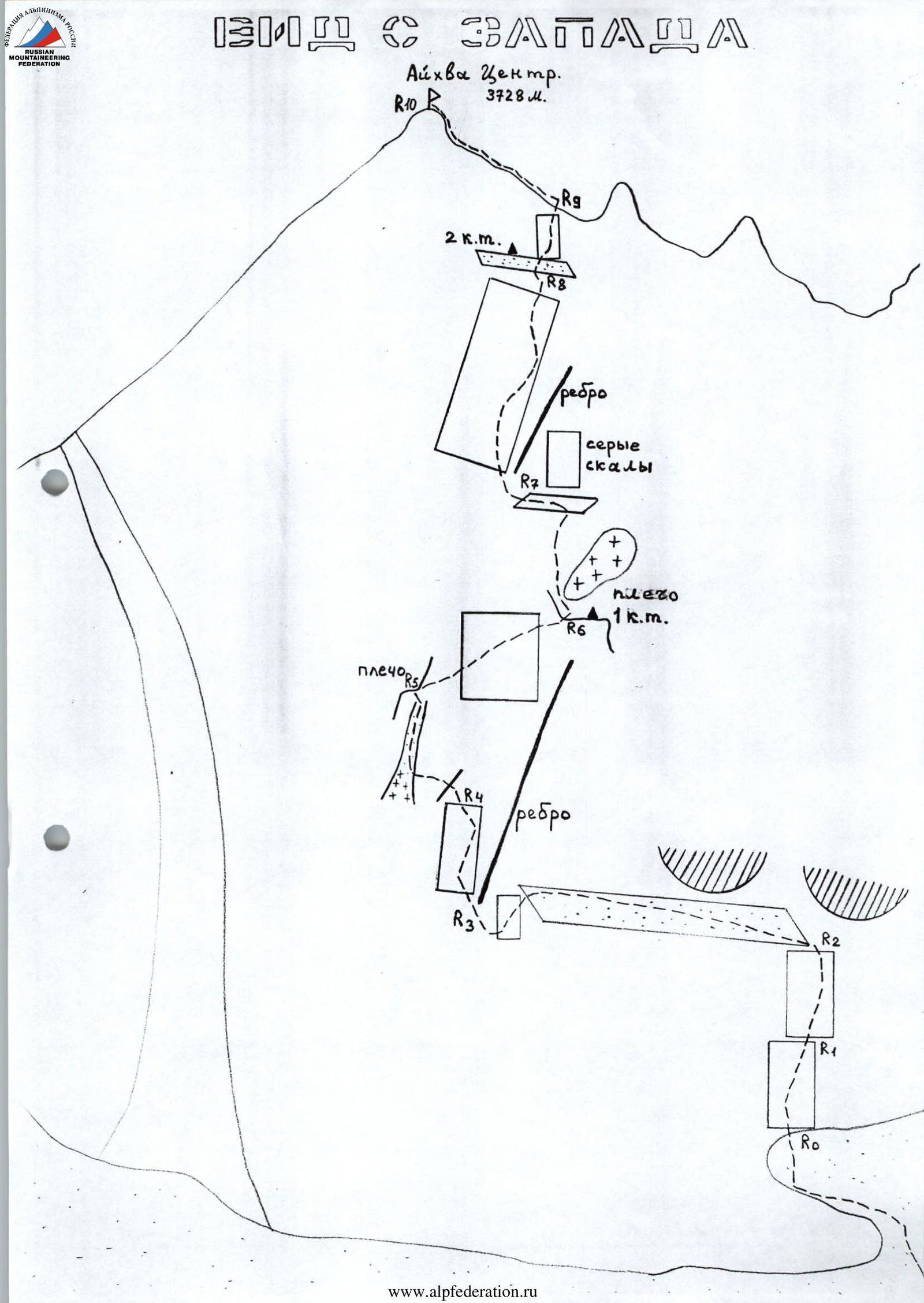
Profile of the Western bastion of Aikhva Tsentr. The first ascent route is marked.
Description of the Approach to the Route (to the Western Aikhva Cirque)
From the "Digoria" alpine camp (now the "Komy-Art" sports and recreation camp), ascend along the road up the Khares gorge to the waterfall — about 1 hour. The waterfall near the road is the Aikhvadon river, flowing out of the Western Aikhva cirque, which is located west of the Southern (Aikhva) spur of the Sugansky ridge.
Bypass the waterfall on the road and cross Aikhvadon to the right bank of the river. Continue ascending towards the visible Aikhva massif. Initially, walk through meadows, then reach the right grassy ridge and follow it until it levels out into a wide, almost flat, grassy valley — another 1.5 hours (height about 2700 m).
Next:
- Go straight up along the river to a steep moraine rise.
- Ascend directly up the moraine rise on the trail, and to the right of the "ram's foreheads," where there is water, reach the camping sites — another approximately 1.5 hours.
The height here is 3100 m, with the Aikhva massif clearly visible ahead. The ascent from the alpine camp is about 1300 m.
View of the Western bastion of Aikhva Tsentr. The first ascent route is marked.
Route Description
From the campsite in the Western Aikhva cirque, head towards the walls of the visible Aikhva massif. Ascend to the base of the triangular Western bastion via a snow-scree terrace, going left upwards and leading to a shoulder at the base of the wall.
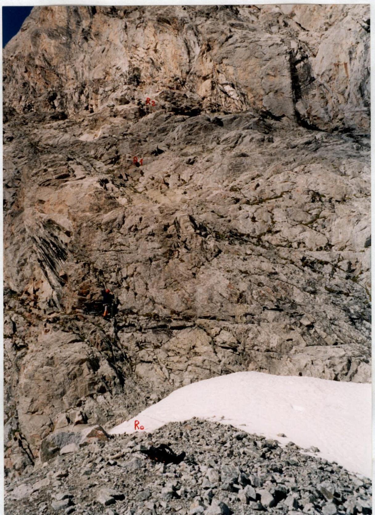
Section R0–R1
From the shoulder (height 3300 m), begin ascending the left part of the wall. Do not go right — the wall is prone to rockfall from above! Section 45 m; 60°; 3–4.
Section R1–R2
Continue straight up under the overhanging rocks to reach a ledge. Another 45 m; 60°; 3–4; in places, the rocks are fragile!
Section R2–R3
Traverse the ledge at 1–2; 20–30°. Move left for about 60 m. Then descend left and traverse left to reach a wide ridge on the wall (another 20 m; 2–3; 40–50°).
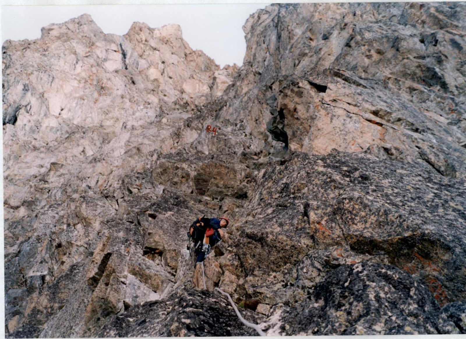
Section R3–R4
Continue left of the ridge up the wall, first at 3, then at 4; 40 m; 60–70°.
Section R4–R5
Ascend left upwards, cross the wall's inflection, and via a narrow snow-scree couloir, exit left to a small shoulder. The entire section is 50 m; 4 — 40 m; 50–60°.
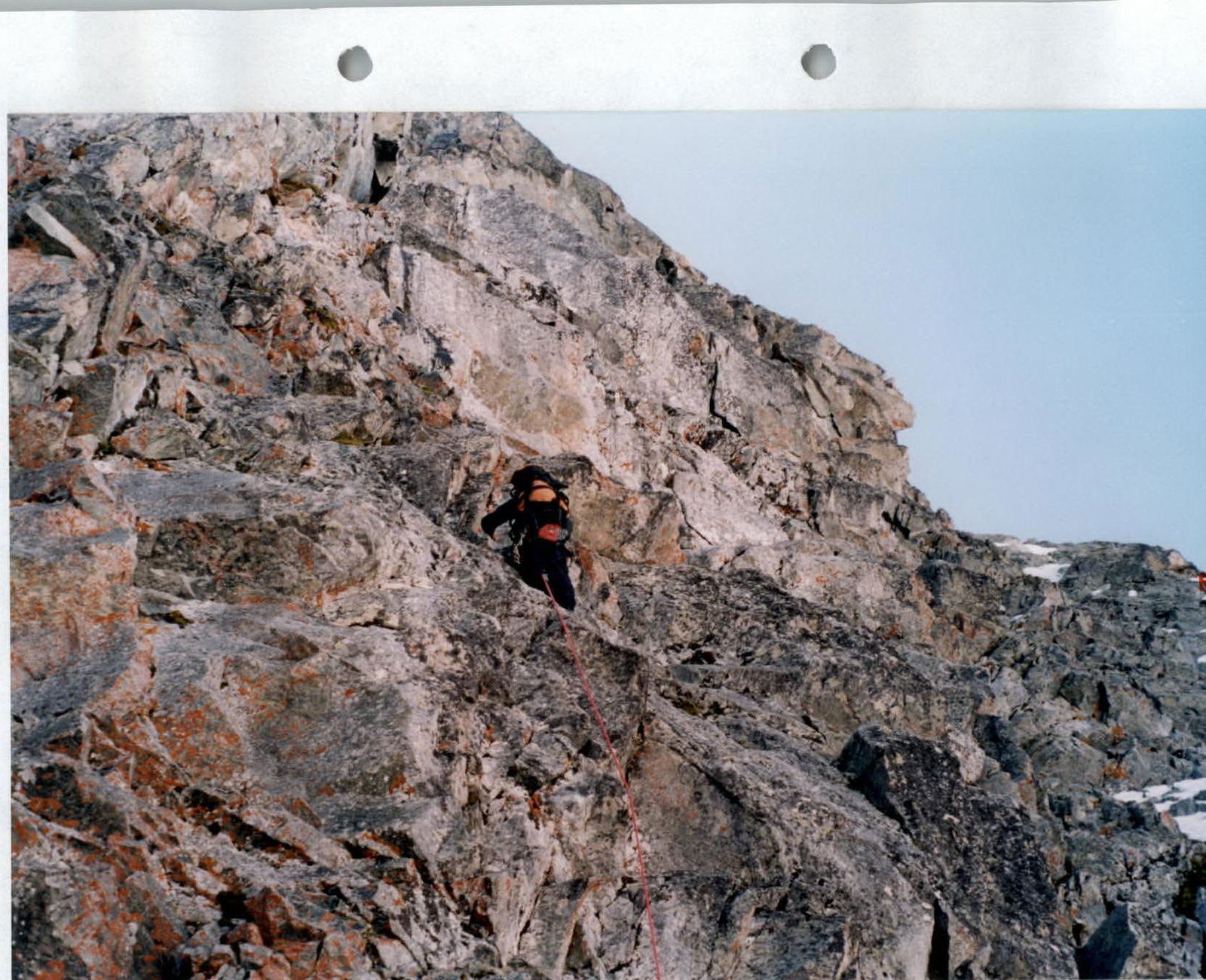
Section R5–R6
From the shoulder, cross the couloir again and ascend the wall left of the visible shoulder on the right against the sky. Section 40 m; 4; 60–70°. In the upper part of the section, exit right onto a shoulder. Further right is the first control cairn.
Section R6–R7
From the shoulder, ascend a snow-scree slope (possible ice) to a ledge under grey rocks. Traverse left to a ridge. Section 40 m; 2–3; 40–50°.
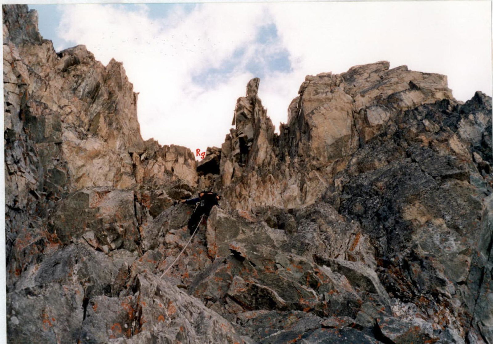
Section R7–R8
Continue straight up the wall towards the visible saddle on the wall's inflection. The ridge and overhanging rocks remain on the right. At the bottom, the wall is 100 m; 60–70°; 4. At the end of the section, reach a ledge. In its left part, under the rocks, is the second control cairn.
Section R8–R9
From the ledge, ascend straight up, left of the "thumb" pinnacle on the wall's inflection. To exit the wall is 20 m; 70–80°; 4. In the lower part, 3 m; 5. For a duo, from the start of the route to the end of the wall, it takes 5–6 hours.
Section R9–R10
Ascend a snow-scree slope left upwards towards the summit — 100 m; 1–2. The summit is a good panoramic point. No signs of human presence were found.
Descent:
- First, descend along the Southern ridge to the saddle,
- then along the Eastern slope, go left downwards on snow under the base of the Aikhva Severная tower,
- further — into the Eastern Aikhva cirque.
The descent route is 1A cat. dif.
Start of the route. Passage of section R0–R1.
Passage of the beginning of section R3–R4.
Passage of the wall on section R5–R6.
Passage of the wall on section R7–R8. The wall's inflection is visible in the distance.

Passage of the final meters of the Western bastion. Wall on section R8–R9.
Conclusions and Recommendations for the Route
The route corresponds to the stated category of difficulty. It can be recommended for sports teams (better in a duo). Passing this route develops skills for working on a wall.
Deviations from the route (especially in the lower part of the bastion) can lead to exposure to rockfall.
The rocks on the route are of a blocky type — granites. Both protection gear and pitons of various sizes are necessary.
The descent should be studied in advance using photographs or reports.
- We descended to the East, the route is 1A cat. dif., into the Eastern Aikhva cirque, and bypassing the Aikhva spur from the south — along a terrace under the cliffs, we reached the campsite in the Western cirque (terrace 3100 m).
- A duo from St. Petersburg, who made the second ascent of the Western bastion on August 2, 2004, descended to the North and further along the 2B cat. dif. route from Aikhva Severная.
- A duo from Vladikavkaz, who made the 3rd ascent of the route on August 14, 2004, descended along a terrace on the Western wall of Aikhva Tsentr. — South with a 20 m rappel, but their path is prone to rockfall after noon, and a photo of the wall with this terrace is required.
We consider the descent into the Eastern Aikhva cirque (1st option) to be the most optimal and safe.