134
Ascent Passport
- Caucasus. Sugansky Ridge, section number according to Classification 2.6.
- Agibalova West (3770 m) — via the South Edge.
- Proposed 2B cat. difficulty, first ascent.
- Route character — rocky.
- Route height difference — 230 m.
Total route length — 285 m. Length of sections 4–5 cat. difficulty — 27 m. Steepness of key sections — up to 80°. Average steepness of the entire route — 45°.
- Hooks left on the route — none.
Used on the route placed elements — 12.
- Travel hours — 4; days — 1.
- Leader: Egorin S. V. — Master of Sports.
Participant: Artashova N. V. — 3rd sports category.
- Coach: Egorin S. V.
- Route exit: July 23, 2006.
- Organization: North Ossetian Search and Rescue Team
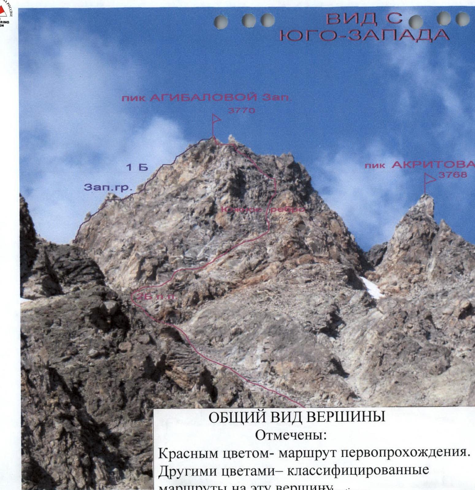
General View of the Summit
Marked:
- Red color — first ascent route
- Other colors — classified routes to this summit
Brief Overview of the Ascent Area
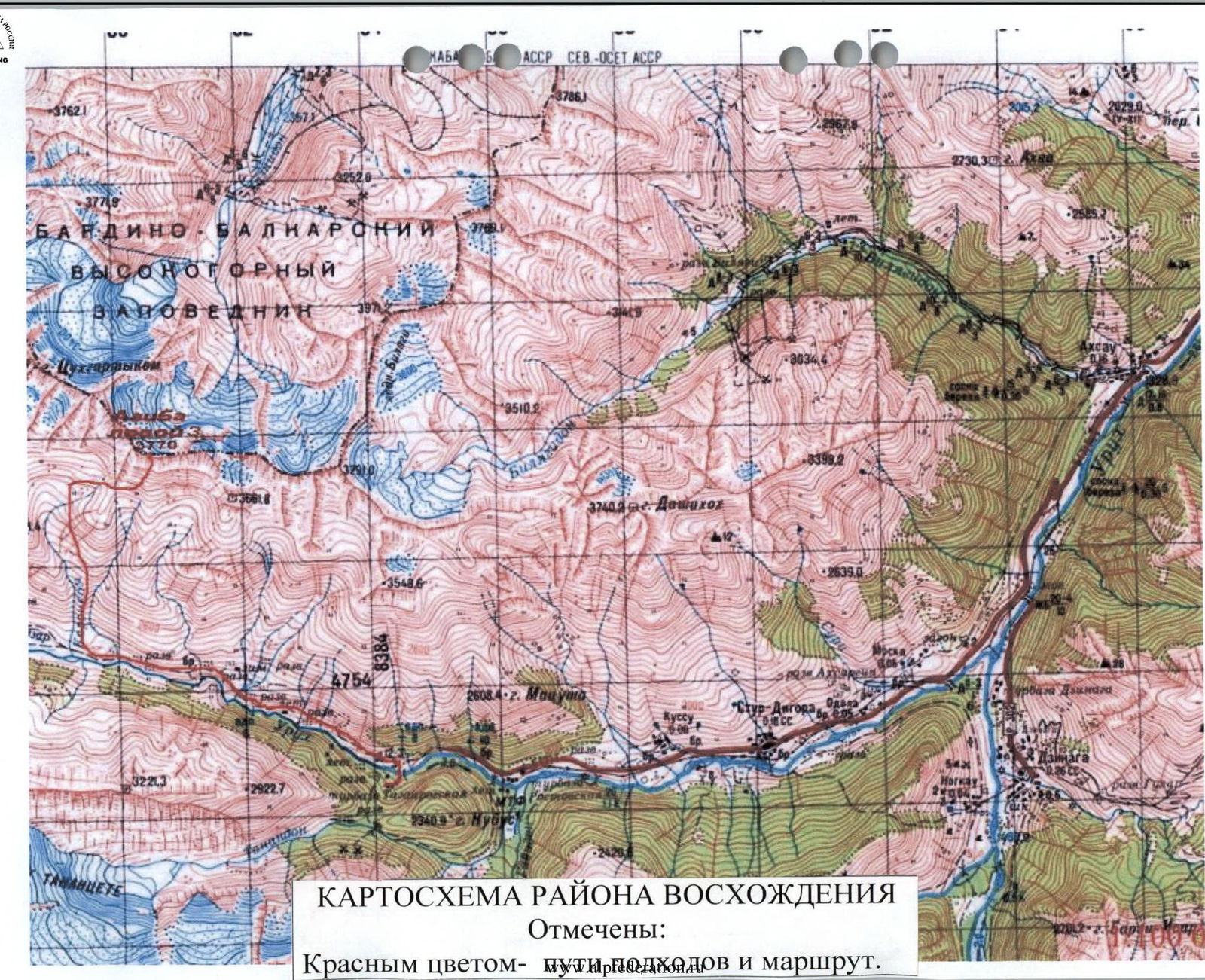
The ascent was made in the Sugansky Ridge. It stretches in a latitudinal direction for almost forty kilometers.
The Sugansky Ridge is located between the rivers:
- Cherek-Balkarsky to the west
- Urukh (Iraf) to the east
Its southern slopes are located on the territory of the Republic of North Ossetia — Alania, and the northern ones — mainly on the territory of the Kabardino-Balkar Republic.
Height characteristics:
- Average heights of its peaks — about 4000 m
- The highest peaks — practically reach 4500 m, rise 1000 m above the snow line
- All passes, even the lowest and relatively accessible ones, are located above 3300 m
- In the central part of the ridge, passes — above 3700 m
The Sugansky Ridge is composed of ancient rocks: light gray granites of the Paleozoic and dense, highly metamorphosed clay shales of the Lower Mesozoic.
The southern slopes of the ridge begin with numerous ridges, edges, and counterforts, местами разрушенными, between which are short, receding, cirque glaciers of southern exposure.
Below are located:
- numerous screes
- moraines from retreated glaciers
At altitudes below 3000 m, alpine meadows begin with a large number of various grasses and flowers that bloom profusely in summer.
The climate of the area is typical for the Caucasus — with a maximum of precipitation in the summer months and an average annual norm of 1500–1600 mm of precipitation. Summer at altitudes above 2500 m is short and relatively cold (average daily temperature in July–August +16 °C). Winter lasts from November to March, frosts can reach −40 °C. Precipitation is relatively low, but after prolonged snowfalls, approaches become avalanche-prone.
The southern slopes of the Sugansky Ridge are well освоены by climbers, who have laid out dozens of routes here from 1B to 5B cat. difficulty.
Ascents from the north differ:
- longer approaches
- harsher conditions
Therefore, they are less frequent, and most of the northern slopes are still waiting for their pioneers.
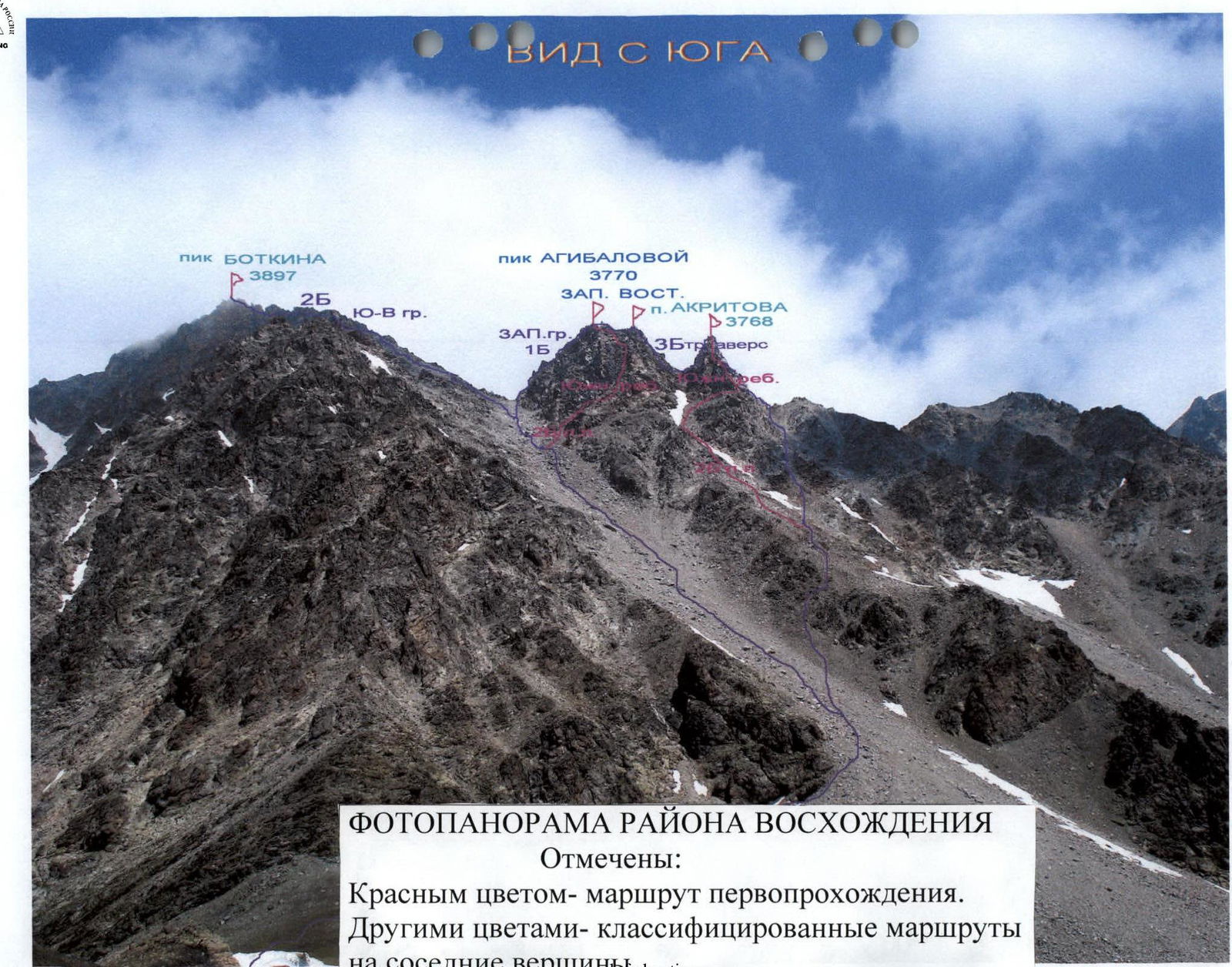
Photopanorama of the Ascent Area
Marked:
- Red color — first ascent route
- Other colors — classified routes to neighboring peaks
Description of the Ascent Route
From Galdor campsite, go east towards a small col in the scree ridge, which branches off to the south from the base of the southern cliffs of Peak Botkin. This col leads to the neighboring cirque under Peaks Agibalova and Akritova.
From the campsite, first, we go along an overgrown moraine, then, having crossed the remains of an avalanche runoff, we begin to ascend up the black fine shale scree. Having reached the col (from the campsite under the sign about 30 min), we approach under the southern cliffs of Peak Botkin. Further, we traverse east under the base of the cliffs. We need to go along the scree slope, traversing with a slight gain in height, to the first wide couloir 200 m.
Further, turn left and go up along the scree along the couloir, with a steepness of 15–20°. At the beginning of summer, there may be snow in the couloir. First, we go along its left side, then we cross into the middle of the couloir. Further, it is necessary to go under the left side of the southern walls of Peaks Agibalova. Approaching under the white quartz cliffs, we turn from the couloir to the right, here to the right up there is a scree terrace.
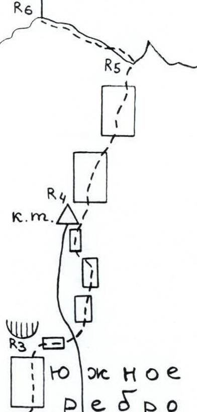
- Section R0–R1: along the scree terrace, go to the right up, to the exit to a small inclined scree shoulder. About 100 m, 1 category, 20–30°.
- Section R1–R2: from the scree shoulder to the right up, along the red rocks. Through the wall 20 m, 4 category, 40–50° exit to an inclined scree shelf and cross it, approaching under the next wall. The entire section is 40 m.
- Section R2–R3: along the wall first to the right, then straight up along the gray blocky rocks (possible rockfall!), to the left of the edge line. Approaching through 40 m under the overhanging rocks, on a small shelf station. Or you can, if the rope is 50 m, go to the right along the slab behind the edge line. The entire section is about 40 m, 3–4 category, in the middle part a section of 4. Steepness 50–80°. For the organization of an intermediate station on the first 40 m, there is no convenient place.
- Section R3–R4: to the right along the slab to go behind the edge line. Along the system of shelves with small walls between them, bypass the South Edge to the right and after 25 m again go left–up, to its shoulder. Here it is necessary to leave a control cairn. Section 2–3 category, 40–60°.
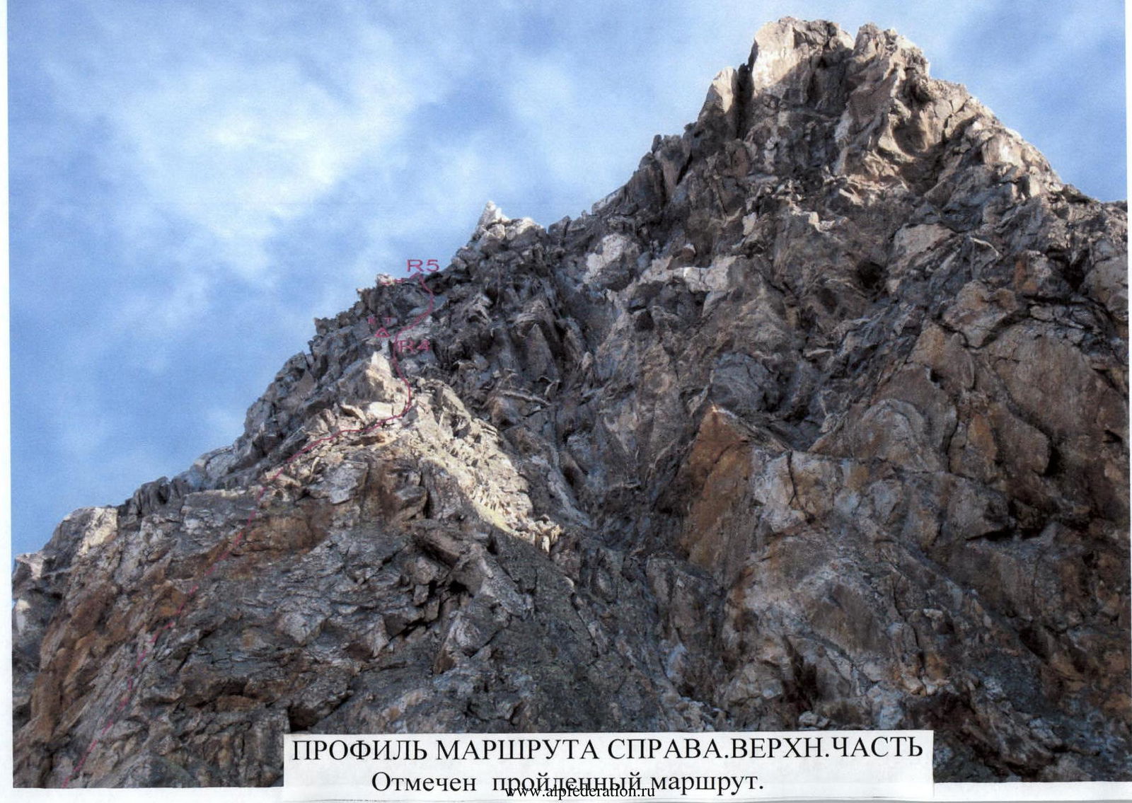
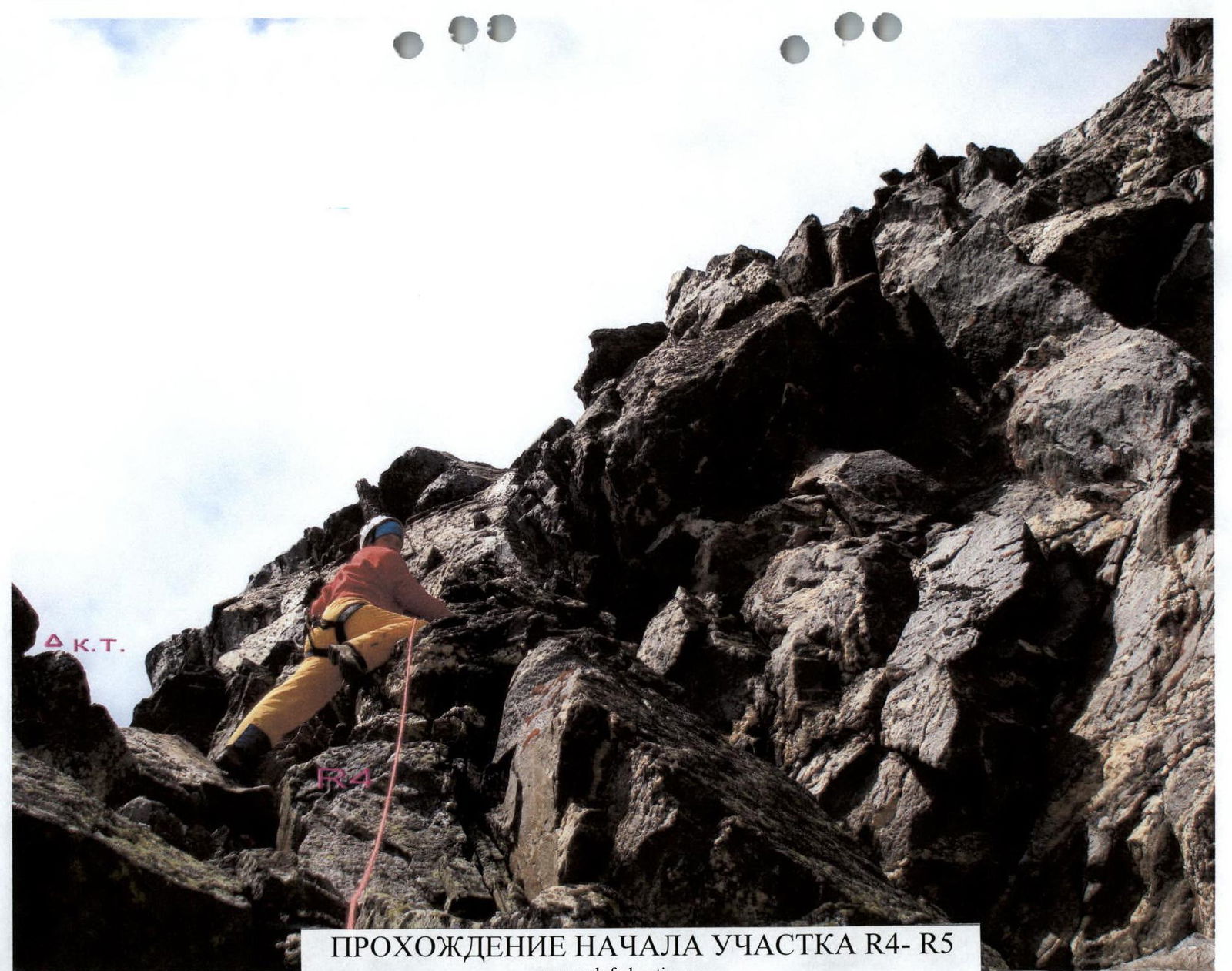
- Section R4–R5: from the shoulder straight up towards the visible ridge ahead. First, along the wall with a section in the middle part 2 m, 5 category, 93° straight up. Then along the shelf to the left and exit to the ridge to the left of the gendarme Finger. The entire section is about 40 m, on average 3–4 category, 50–60°.
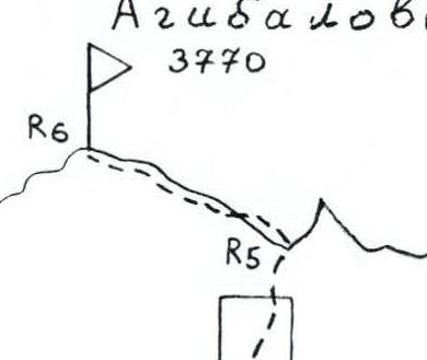
- Section R5–R6: on the ridge, turn left and along the ridge line, along the rocks 2–4 category, through 40 m climb to Peak Agibalova West.
From the start of the route for a training group 4–5 hours.
Descent along the Western Ridge along the route 1B cat. difficulty to the Galdor East pass. And further to the left down the couloir.

Peak Agibalova 3770

View from the southeast
Agibalova West
Be prepared!
Conclusions and Recommendations for the Route
The passed route corresponds to the declared category of difficulty. Can be recommended for passage by training and sports groups.
Passing the route allows you to practice rope work skills.
The rocks on the route are местами of block type, so it is recommended to have a set of placed elements with you.
At the beginning of summer, in couloirs, there may be a hard snowy slope early in the morning. Therefore, it may be necessary to take crampons with you on the route.
It is convenient to exit to the route from Galdor campsite. The approach to the start of the route is convenient and goes virtually without loss of height.
When moving along scree couloirs, it is necessary:
- to go in a tight group,
- so as not to knock stones on each other.
On the route, belay is needed on sections from 2 category and above. On the ridge, it can be carried out through:
- numerous ledges,
- hooks,
- placed elements.
Footnotes
-
AREA CLIMBING MAP. Marked: Red color — approach paths and route. ↩