I. Climbing category.
Rock climbing.
-
Climbing area, ridge. Central Caucasus, Main Caucasian Range.
-
Peak, its height, climbing route. Tsanner peak, 4000 m, via the N counterfort of the W ridge.
-
Proposed difficulty category. 4A category.
-
Route characteristics:
- Height difference: 1500 m.
- Length of sections with fifth category difficulty: 40 m.
- Average steepness: 55°.
- Pitons hammered:
- rock pitons for belay: 14 pcs.
- rock pitons for ITO: 1 pc.
- chocks placed: 18 pcs.
-
Number of travel hours: 16 hours.
-
Number of nights and their characteristics: One overnight stay on the descent on Shartu glacier. Lying down.
-
Surname, name, patronymic of participants and their qualification:
- Zander Sergey Egonovich, 1st sports category.
- Mozhaev Mikhail Vasil'evich, 1st sports category.
- Glushkovsky Alexander Edgarovich, Master of Sports.
-
Team coach:
-
Date of departure on the route: August 15, 1980.
-
Date of return from the route: August 16, 1980.
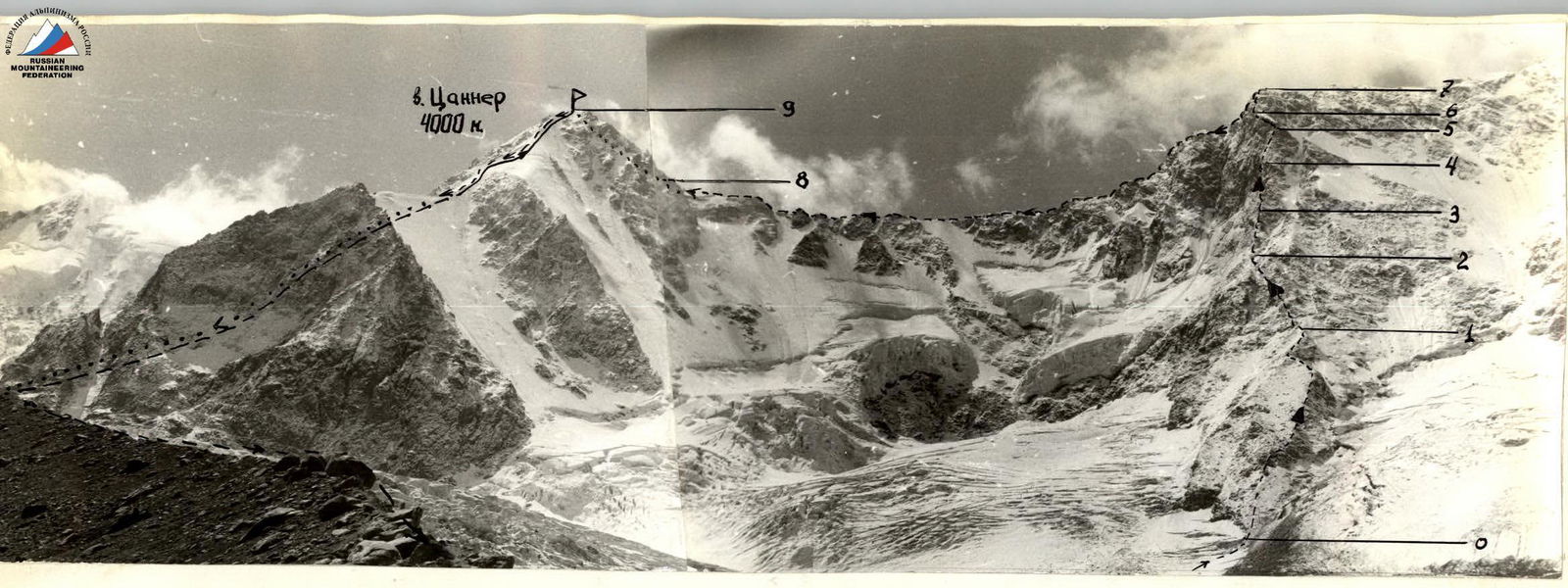
The group's path Invisible part of the path Previously traversed route: Tsanner peak via N ridge, 3A category. Invisible part of the path

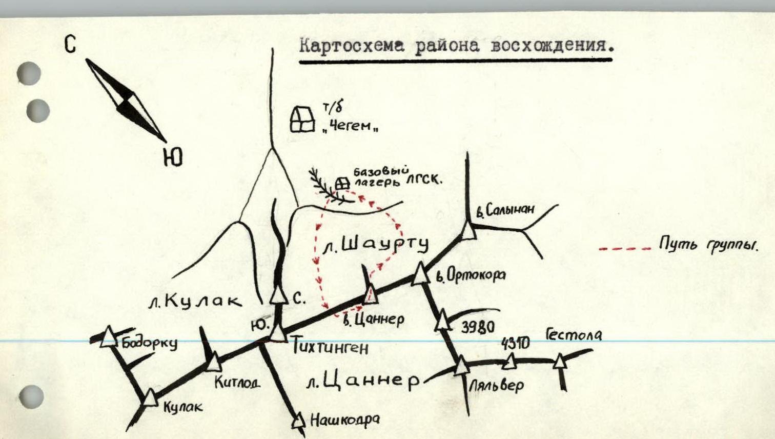
Brief description of the approach to the route on Tsanner peak via the N counterfort of the W ridge, 4A category.
From the "Chegem" tourist base, up along the right (or.) bank of the Shartu gorge to the platforms at the end of the right-bank moraine of the Shartu glacier (location of the base camp of the Len gor sport committee gatherings) — 2.5–3 hours.
From the platforms, cross the moraine and Shartu glacier (crevasses) to the right upwards in the direction of the rocky spur of the N counterfort of the W ridge.
The N counterfort descends approximately from the middle of the ridge between the peaks:
- TSANNER (left along the route)
- S. Tikhtingen (right).
Tsanner peak (4000 m) is located on the Main Caucasian Range between:
- the nodal massif of the MCR Tikhtingen (4610 m), consisting of the S (main) and N peaks from the west,
- the nodal peak of the MCR Ortokara (4250 m) from the east.
The first ascent of Tsanner peak was made by L. Matyushin's group on August 17, 1959, via the N ridge, 3A category.
I. Group composition
The ascent was made by members of the sports club of the Leningrad Electrotechnical Institute named after V.I. Ulyanov (Lenin) consisting of:
- Zander S.E., 1st sports category.
- Mozhaev M.V., 1st sports category.
The participants were examined and allowed to climb by the doctor of the Len gor sport committee gatherings, Kuznetsov S.I. Both participants had life insurance policies and had experience of joint climbs over a period of four years.
II. Preparation for the ascent
The participants underwent physical and technical training during the winter period. Before the Len gor sport committee gathering in the Chegem gorge, the participants had a forty-day gathering in the Fann Mountains. Immediately before the ascent to Tsanner peak, the participants completed:
- rock climbing training,
- snow training,
- ice training.
A reconnaissance sortie was also conducted under the base of the proposed route.
III. Tactical plan of the ascent
After studying the route, the following tactical plan was chosen: August 15, 1980.
- Departure from the base camp of the Len gor sport committee gatherings at 4:00
- Approach to the base of the rocky spur by 5:00
- Ascent to the W ridge of Tsanner peak by 12:00
- Approach to the pre-summit rise by 14:00
- Ascent to the summit by 16:00
- Descent to the Shartu glacier by 19:00
- Return to the base camp of the Len gor sport committee gatherings by 20:00
The backup plan provided for an overnight stay on the descent from Tsanner peak and return to the base camp of the Len gor sport committee gatherings on August 16, 1980.
This plan was carried out with minor deviations.
IV.I Table of main characteristics of the ascent route
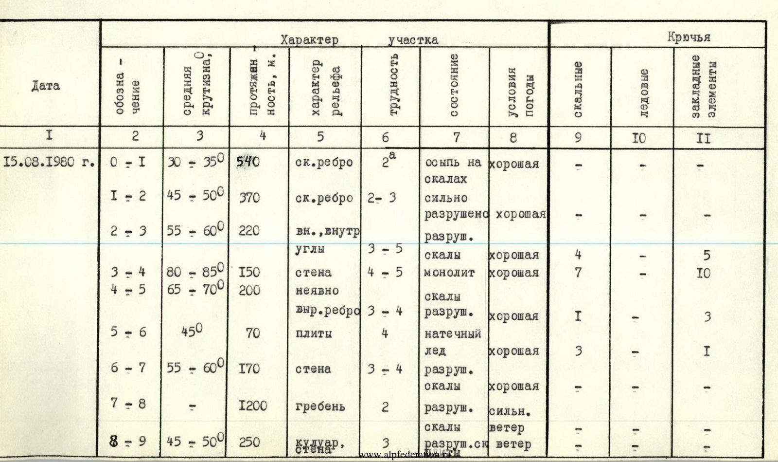
| Date | Designation | Average steepness, ° | Length, m | Terrain characteristics | Difficulty | Condition | Weather conditions | Rock pitons | Ice pitons | Chocks |
|---|---|---|---|---|---|---|---|---|---|---|
| August 15, 1980 | R0–R1 | 30–35 | 540 | rocky ridge | 2 | scree on rocks | good | – | – | – |
| August 15, 1980 | R1–R2 | 45–50 | 370 | rocky ridge | 2–3 | heavily destroyed | good | – | – | – |
| August 15, 1980 | R2–R3 | 55–60 | 220 | internal corners | 3–5 | destroyed | good | 4 | – | 5 |
| August 15, 1980 | R3–R4 | 80–85 | 150 | wall | 4–5 | monolithic | good | 7 | – | 10 |
| August 15, 1980 | R4–R5 | 65–70 | 200 | vaguely defined ridge | 3–4 | destroyed rocks | good | 1 | – | 3 |
| August 15, 1980 | R5–R6 | 45 | 70 | slabs | 4 | ice accretion | good | 3 | – | 1 |
| August 15, 1980 | R6–R7 | 55–60 | 170 | wall | 3–4 | destroyed rocks | good | – | – | – |
| August 15, 1980 | R7–R8 | – | 1200 | ridge | 2 | destroyed rocks | strong wind | – | – | – |
| August 15, 1980 | R8–R9 | 45–50 | 250 | couloir, wall | 3 | destroyed rocks | wind | – | – | – |
V. Route description
From the base camp of the Len gor sport committee gatherings, located in the pocket of the right-bank (or.) moraine of the Shartu glacier, cross the glacier (cautiously — crevasses) and approach the base of the rocky spur descending from the W ridge on its left (or.) side (1–1.5 hours), situated between two icefalls. To the left of the rocky spur, in the upper part, a steep rocky counterfort is visible. Then ascend the spur to the beginning of the left counterfort, separated from the spur by a narrow ice-snow couloir (2–2.5 hours). Cross the couloir (possible rockfall!) and approach the base of the counterfort via simple destroyed rocks. On an inclined scree shelf — a guiding cairn. Then move along the counterfort according to the detailed scheme of passage of the counterfort given below, and exit onto the W ridge (4.5–5 hours).
Then, along the heavily destroyed W ridge, move in the direction of Tsanner peak and approach its pre-summit rise (2 hours). There are good places for overnight stays on the ridge.
Then:
- Up the rocks on the left side of the scree couloir — 80 m.
- Cross to the right side of the couloir.
- Via rocks of medium and above medium difficulty — exit onto Tsanner peak (1 hour).
Descent from the summit along its N ridge — 3A category.
Scheme of passage of the N counterfort of the W ridge of Tsanner peak
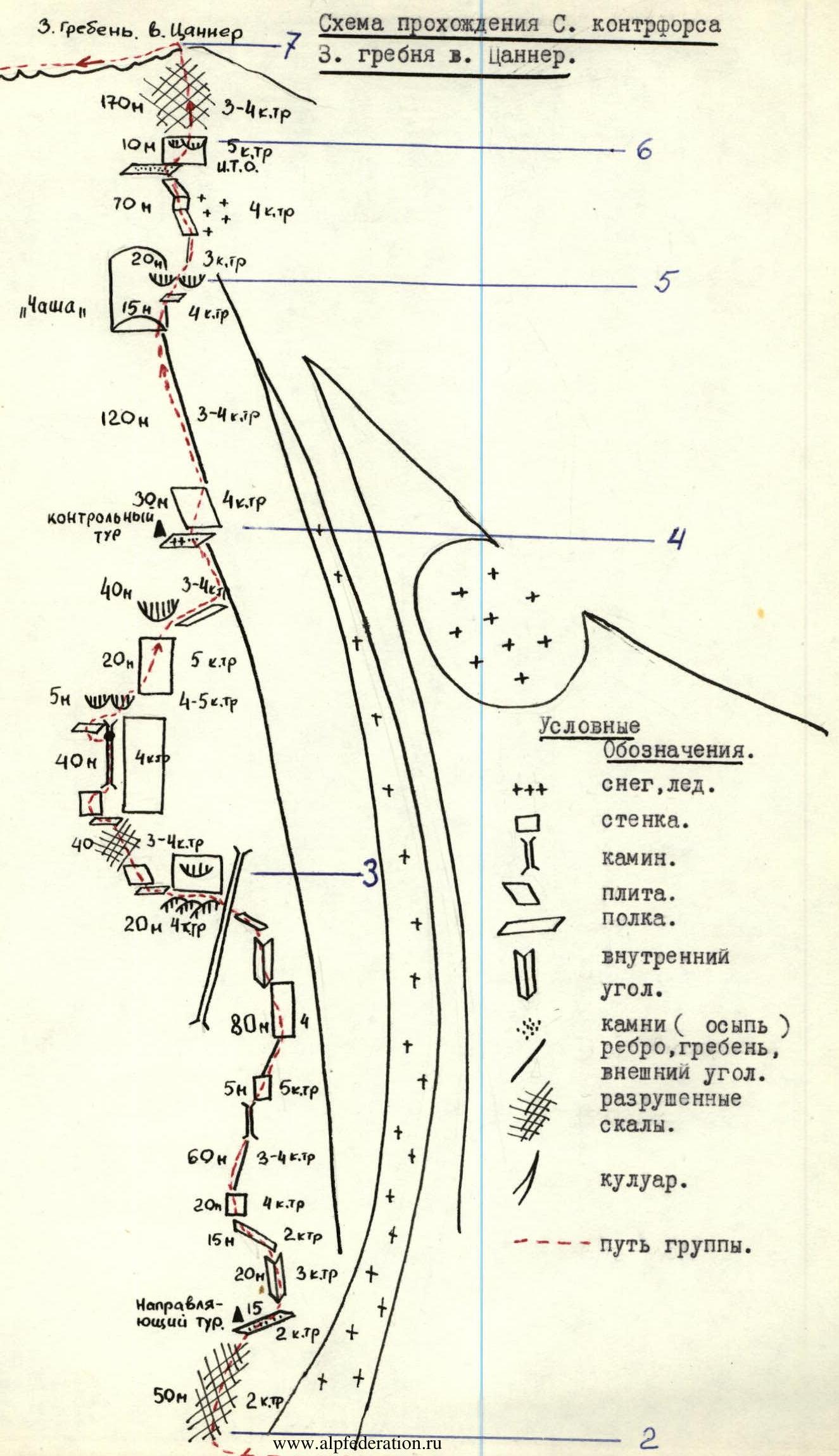
Conventional symbols:
- Snow, ice.
- Wall.
- Chimney.
- Slab.
- Shelf.
- Internal corner.
- Rocks (scree), ridge, external corner.
- Destroyed rocks.
- Couloir.
- Group's path.
Route sections (according to the scheme):
- 170 m, 3–4 category.
- 10 m, 5 category, ITO.
- 70 m, 4 category.
- 20 m, 3 category.
- "Bowl"
- 15 m, 4 category.
- 120 m, 3–4 category.
- 30 m, control cairn, 4 category.
- 40 m, 3–4 category.
- 20 m, 5 category.
- 5 m, 4–5 category.
- 40 m, 4 category.
- 40 m, 3–4 category.
- 20 m, 4 category.
- 80 m, 4 category.
- 5 m, 5 category.
- 60 m, 3–4 category.
- 20 m, 4 category.
- 15 m, 2 category.
- 20 m, 3 category.
- Guiding cairn: 15 m, 2 category.
- 50 m, 2 category.