Ascent Passport
- Ascent class — technical.
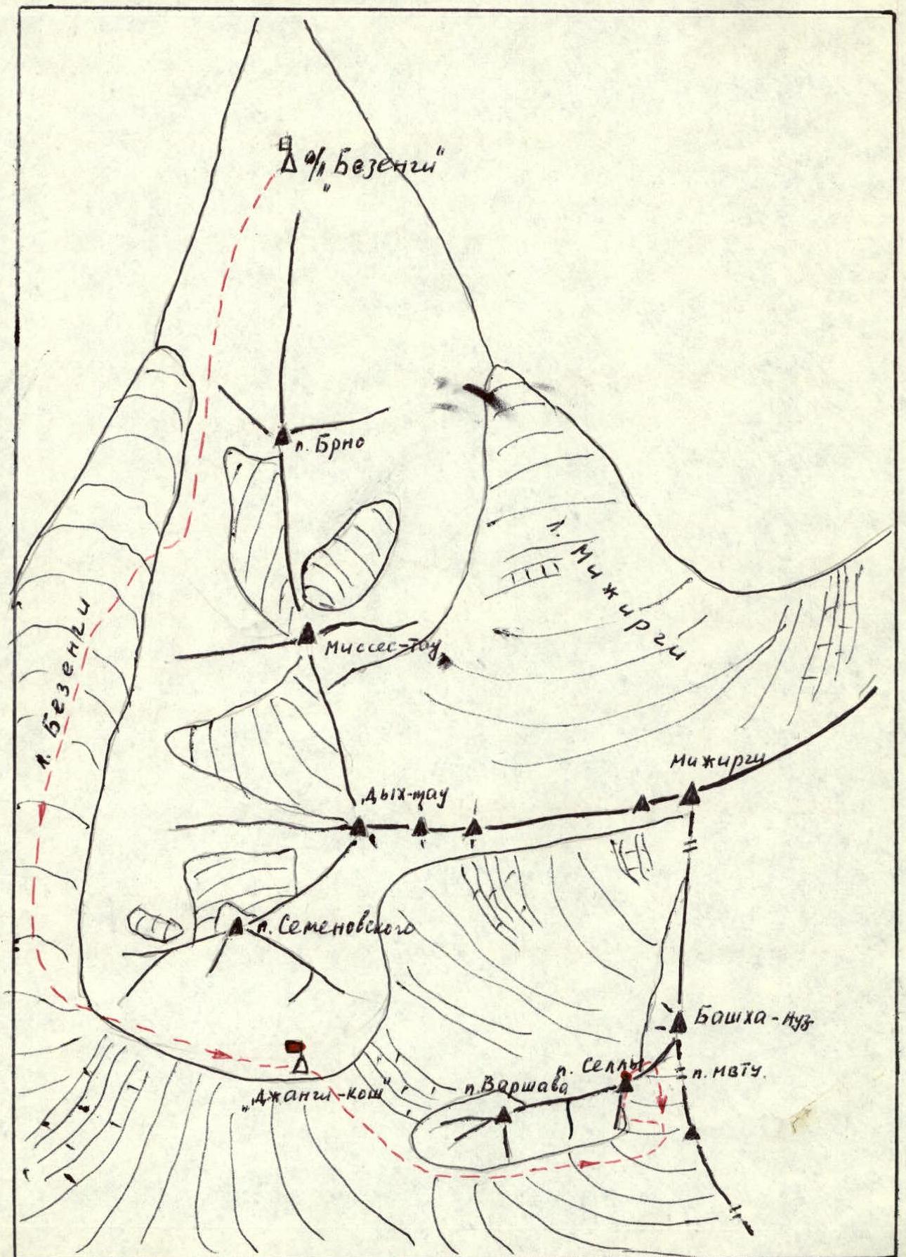
- Ascent area — from Kitlod settlement to Gezevcek settlement.
- Peak, its height, and ascent route — p. Sella, 4382 m, via the South ridge.
- Proposed difficulty category — 2B.
- Route characteristics:
height difference — 450 m average steepness — 55° length — 530
- Pitons hammered in: for belaying, for creating, etc.
| Rock | 4 | 0 |
|---|---|---|
| Ice | 0 | 0 |
| Bolt | 0 | 0 |
- Number of travel hours — 4 hours.
- Number of overnight stays and their characteristics — no overnight stays on the route.
- Surname, name, patronymic of the leader and participants, their sports qualification: participants: 1. Saratov Yuri Sergeevich, Master of Sports 2. Golub Yuri Ivanovich, Candidate for Master of Sports
- Team coach — instructors of the Bezengi region Alpine Camp.
- Date of departure on the route and return — July 20, 1980 – July 20, 1980.
Route Description
From the “Jangi-kosh” hut through the “sickle-shaped” moraine, onto the Bezengi glacier and along the “pocket” between the zone of marginal crevasses and the S. slopes of Peak Varshava (attention — rockfall hazard from the left, hidden crevasses), bypassing the bases of three S. spurs of the main ridge, into the SW cirque of Bashha-auz-bashi, then along the cirque to the left under the slopes of the S. ridge of p. Sella. From the hut: 2 hours 30 minutes.
Through the bergschrund, ascent up the snowy slope with a steepness of 30° (possible ice), ascent to the S. ridge of p. Sella (120 m). Along the easy ridge (60 m) to the rock ascent. The rock ascent is a moderate complexity rock face (60 m) with an internal angle steepness of 70°. (Belaying through outcrops, pitons). Then along the easy ridge (60 m) to the summit tower. Up the moderate complexity rocks, then along a ledge traverse to the right (attention — rockfalls above the ledge!). Further movement up and to the right along moderate complexity slabs (60 m). Ascent to the summit along moderate complexity rocks to the left. Belaying with pitons and through outcrops. Ascent to the summit of p. Sella takes approximately 3 hours.
Descent from the summit to the NE along the snowy ridge leading to v. Bashha-auz-bashi (caution — to the left, the slope has progressively increasing steepness; to the right — cornices!). Belaying through ice axe. After the steep lowering of the ridge with a talus col, descend to the right down the rock outcrops and snowy slope to the bergschrund. Descent into the initial SW cirque Bashha-auz-bashi takes about 1 hour. Along the right side of the glacier, bypassing the S. spurs of the Varshava–Sella ridge to the hut — 1 hour.
Hazardous areas:
- On the Bezengi glacier — hidden crevasses.
- Rockfall hazard from the S. slopes of Peak Varshava.
- On the NE ridge of Peak Sella, cornices to the right are possible.
Special equipment:
- Rock pitons — 5–6 pcs.
- Ice pitons — 3–4 pcs, crampons 1–2 pairs, in case there is ice on the slope leading to the South ridge of p. Sella.