XXX USSR Alpine Climbing Championship — Rock Climbing Category — Central Caucasus, Skalisty Ridge
REPORT OF THE ARMED FORCES TEAM ON THE ASCENT OF AK-KAYA PEAK VIA THE CENTRAL BASTION OF THE SOUTHEAST FACE
- Mikhailov A.A. — team leader and coach — Master of Sports
- Evsyukov G.K. — deputy leader — Candidate for Master of Sports
- Baychenko Yu.P. — participant — Master of Sports
- Sarkisov L.A. — participant — Candidate for Master of Sports
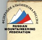
— Route of the Baksan Alpine Camp team — Route of the Instructors' School team — Route of the USSR Armed Forces team — Route of the Dzhailyk Alpine Camp team
 Photo 1. General view of the Southeast face of Ak-Kaya peak.

Photo 3. Profile of the ascent route via the Central Bastion of the Southeast face of Ak-Kaya peak.
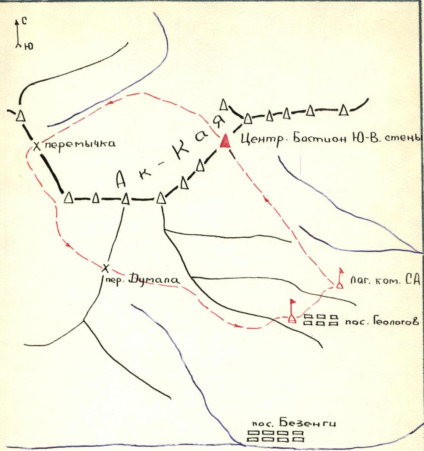
— Route of the Soviet Army team to and from Ak-Kaya peak. — Judges' Category base camp. Map of the USSR Championship area (Skalisty Ridge)
DESCRIPTION OF THE APPROACH TO THE ROUTE
The Ak-Kaya peak massif is located in the Skalisty Ridge of the Caucasus and serves as a watershed between the Cherek Bezengiysky River basin and the Chegem River basin. To the west, the massif is bounded by the Dumala Pass, and to the east, it gradually descends and ends near the village of Karasu. From the village of Bezengi, a dirt road leads to the southern and southeastern slopes of the Ak-Kaya peak massif, ending slightly above the geologists' camp. From the camp, trails and then grassy slopes lead to the clearly visible routes on the southern and southeastern faces of Ak-Kaya peak within 2.0–2.5 hours. Descent from any point on the massif is possible via two paths: — to the east — to the village of Karasu via scree slopes starting directly from the summit and grassy slopes; — the second path — through a canyon starting from the western part of the Skalisty Ridge, to the Dumala Pass, and then down to the Geologov settlement via the road. The return time to the settlement is 4–5 hours.
INFORMATION ON RECONNAISSANCE AND SUPPLY TRIPS
The Armed Forces team arrived at the USSR Alpine Climbing Championship venue on July 8, 1979, setting up a base camp near the Geologov settlement — the location of the judges' brigade and most participating teams. A reconnaissance trip was conducted on July 9, 1979, from 5:00 to 13:00. The trip aimed to: — familiarize themselves with the Ak-Kaya peak massif, — explore approach routes, — select routes (primary and alternative) for discussion by the coaching council, — inspect the condition and potential features of the routes. The reconnaissance route involved traversing the base of the peak massif at a distance of 50–300 m from the wall's base. The reconnaissance group consisted of:
- Evsyukov G.K. — Candidate for Master of Sports
- Baychenko Yu.P. — Master of Sports
- Samoilov V.A. — Master of Sports
- Sarkisov L.A. — Candidate for Master of Sports The reconnaissance group successfully completed its task. A supply trip to cache equipment (tent, some food, gasoline) under the route was conducted on August 2, on the eve of the ascent, by the team:
- Mikhailov A.A. — Master of Sports — leader
- Evsyukov G.K. — Candidate for Master of Sports
- Baychenko Yu.P. — Master of Sports
- Sarkisov L.A. — Candidate for Master of Sports The trip was conducted from 2:00 to 15:00 on August 2.
ASCENT TACTICS
I. Team Composition
After the training camp before the USSR Championship, the USSR Armed Forces alpine climbing team was formed. The team consisted of athletes with extensive experience in joint rock climbing ascents of 5B–6B difficulty category:
- Mikhailov A.A., Master of Sports, leader and coach
- Evsyukov G.K., Candidate for Master of Sports, deputy leader
- Baychenko Yu.P., Master of Sports
- Sarkisov L.A., Candidate for Master of Sports
II. Equipment
During the ascent, equipment made of titanium and duralumin was used. A variety of hooks and anchor devices of different configurations were taken on the route. Minimal use of piton hooks was intended. The use of titanium ice hooks with a conical shape proved effective for rock climbing. For moving along the rope, "Jumar" type clamps and others were used. The lead climber used an experimental weighted hammer of their own manufacture. All participants had lightweight backpacks made of avizent.
III. Safety Measures During the Ascent
Safety during the ascent was ensured by: — high technical preparation of participants, — rational selection of equipment and supplies, — rotation of lead climbers, — use of double rope for belaying the first climber, — top belay when moving along the rope, — individual safety gear (helmets, climbing harnesses, etc.).
IV. Style of Climbing Complex Sections
Sections of the route with 5B–6B difficulty category were climbed using free climbing with minimal artificial support points. Other participants followed with backpacks along the rope using clamps and top belay. On overhanging sections, backpacks were pulled up.
V. Environmental Protection
Minimal use of products in metal cans was planned, with the descent of used cans and packaging to the base camp.
VI. Route Selection and Time Calculation
The planned route was intended to be completed in four days, with preliminary processing of the summit tower from the last bivouac site on the wall. Potential bivouac sites were identified based on the planned time and wall relief. During the ascent, the correctness of: — time calculation for the route, — chosen bivouac sites, — selected path, was confirmed.
COMPOSITION OF THE OBSERVATION GROUP
- Volynets G.I. — 1st sports category
- Laskavy D.P. — Candidate for Master of Sports Total weight of food, equipment, and gasoline taken for the ascent: 89 kg 50 g.
TABLE OF MAIN CHARACTERISTICS OF THE ASCENT ROUTE
| Date | Section # | Average angle | Length, m | Terrain characteristics | Difficulty category | Condition | Weather conditions | Rock hooks | Ice | Piton | Anchor devices |
|---|---|---|---|---|---|---|---|---|---|---|---|
| 2 | 3 | 4 | 5 | 6 | 7 | 8 | 9 | 10 | 11 | 12 | |
| 12.07.1979 | R0–R1 | 95 | 40 | Wall | 6 | Monolith | Fog | 1Б+П | - | - | 1 |
| R1–R2 | 85 | 40 | Wall | 6 | Monolith | Fog | 14 | - | П | 2 | |
| R2–R3 | 85 | 40 | Wall | 6 | Monolith | Fog | 10;Ш | - | - | 2 | |
| R3–R4 | 75 | 40 | " | 5Б | " | " | 8 | - | - | - | |
| R4–R5 | 75 | 40 | " | 5А | " | Rain | 7 | - | - | - | |
| Departure time — 9:15. Bivouac stop time — 19:30. |