XXX USSR Climbing Championship
- Rock climbing category — Central Caucasus, Skalisty Ridge
Ascent Passport
- Peak, its height — Ak-Kaya Massif
- Ascent route — Central peak of the South face via the buttress
- Proposed category of difficulty — 5B
- Route characteristics:
- Height difference: 440 m
- Section length: 180 m, 230 m
- Average steepness: 72°
- 5–6 technical grade
- Pitons hammered:
- Rock: 102 (for belay), 8 (for creating I.T.O.)
- Boulder: 1 (for belay), — (for creating I.T.O.)
- Chocks: 2 (for belay), 7 (for creating I.T.O.)
- Total hours of climbing — 23 hours
- Number of bivouacs — 1 and their characteristics — semi-sitting on a 1.5–2 m wide ledge
- Surname, name, patronymic, and qualification:
- Team leader: Tyulpanov Sergey Sergeyevich, Master of Sports of the USSR
- Participants:
- Andreyev Leonid Alexandrovich, Master of Sports of the USSR
- Volkov Valery Timofeyevich, Candidate Master of Sports
- Stepanov Yevgeny Petrovich, Candidate Master of Sports
- Team coach: Honored Coach of the RSFSR Zhirnov Viktor Vasilyevich
- Date of departure to the route — July 12, 1979 and return — July 13, 1979
Signature:
(Tyulpanov)
 www.alpfederation.ru↗
Information on reconnaissance and supply trips
The team surveyed the Ak-Kaya massif from the village of Bezengi during their arrival at the "Bezengi" alpine camp. On July 6, they traveled to the geologists' base camp. On July 6, they conducted their first reconnaissance and photographed the massif. On July 7–8, there was fog, but the team approached the chosen routes and was able to examine their beginnings and study the rockfall patterns. On July 9, they conducted a reconnaissance and survey of the routes in the morning. The Volkov-Andreyev rope pair went to the Dumala pass and returned to the base camp, traversing the foot of the entire wall. The Tyulpanov-Stepanov rope pair traversed the foot of the wall from the 3270 m peak to the Dumala pass. On July 10, they conducted a final reconnaissance of the chosen route — to the Central peak of the Ak-Kaya massif via the South buttress and identified a camp for observation near a spring. In addition to visual reconnaissance, the team used topographic and geological maps, aerial photographs, and amateur photos taken by geologists. They consulted with geologists about the structure and type of rock that makes up the massif.
Tactics for the ascent (Use of new equipment samples)
-
The key to a successful ascent is ensuring safety. This was achieved by: a) The first climber always using a double rope, one of which was a continuously used elastic Italian rope that was clipped into every piton; the other, a stiffer rope from West Germany, was clipped every 2–3 pitons and left as a fixed rope. b) Securing the fixed rope to at least two independent points (pitons). c) While the second climber was moving, they would secure the fixed rope to 2–3 intermediate pitons. d) Movement along the fixed rope was done using two jumar ascenders. e) The first climber tried not to be directly above the group; belay points and re-clipping points were set up under overhanging sections whenever possible, which, despite the very broken rock, helped avoid being hit by falling rocks.
-
The team aimed to complete the route as quickly as possible. This was achieved by: a) Frequently changing the lead climber (every 2–4 pitches) within a rope or between ropes, allowing the lead climber to work at maximum pace without experiencing psychological or physical overload. b) The lead climber always climbed without a backpack. c) The last climber had a hammer-piton remover, which significantly increased the speed of piton removal. d) Given that the climbing area was low and warm, the group minimized their bivouac equipment, personal items, and food. The total weight of their equipment, including clothing and personal items, was 54 kg. e) In the winter preceding the climb, they prepared specialized equipment for the rock climbing category: lightweight dacron backpacks (0.3 kg each), down vests and "legs" (1.2 kg per set), and sleeping pad mats made of penoron (excellent thermal insulation, non-brittle, lightweight, waterproof). They also made tubular pitons from soft titanium, specifically designed for broken rock, and long (over 120 mm) and thin (3 mm) titanium combination pitons. This equipment was tested in 1978 on the Mirali peak and in 1979 in the Skalisty Ridge. The team had eight different types of pitons.
They developed chocks of various types and sizes:
- camming devices
- prismatic chocks
- hexes.
Jumar ascenders that prevented accidental unclipping of the rope. "Meta" portable stove weighing 0.3 kg including pot and fuel.
Brief description of the approach to the route
From the village of Bezengi, it's possible to drive to the geologists' settlement by car. From the settlement, a grassy ridge leads towards the Central peak of the Ak-Kaya massif.
Following the ridge, staying to its right side, walk for 1–30 minutes until you reach a visible spring. There's water and a suitable bivouac site.
From the bivouac to the start of the route takes 30–40 minutes.
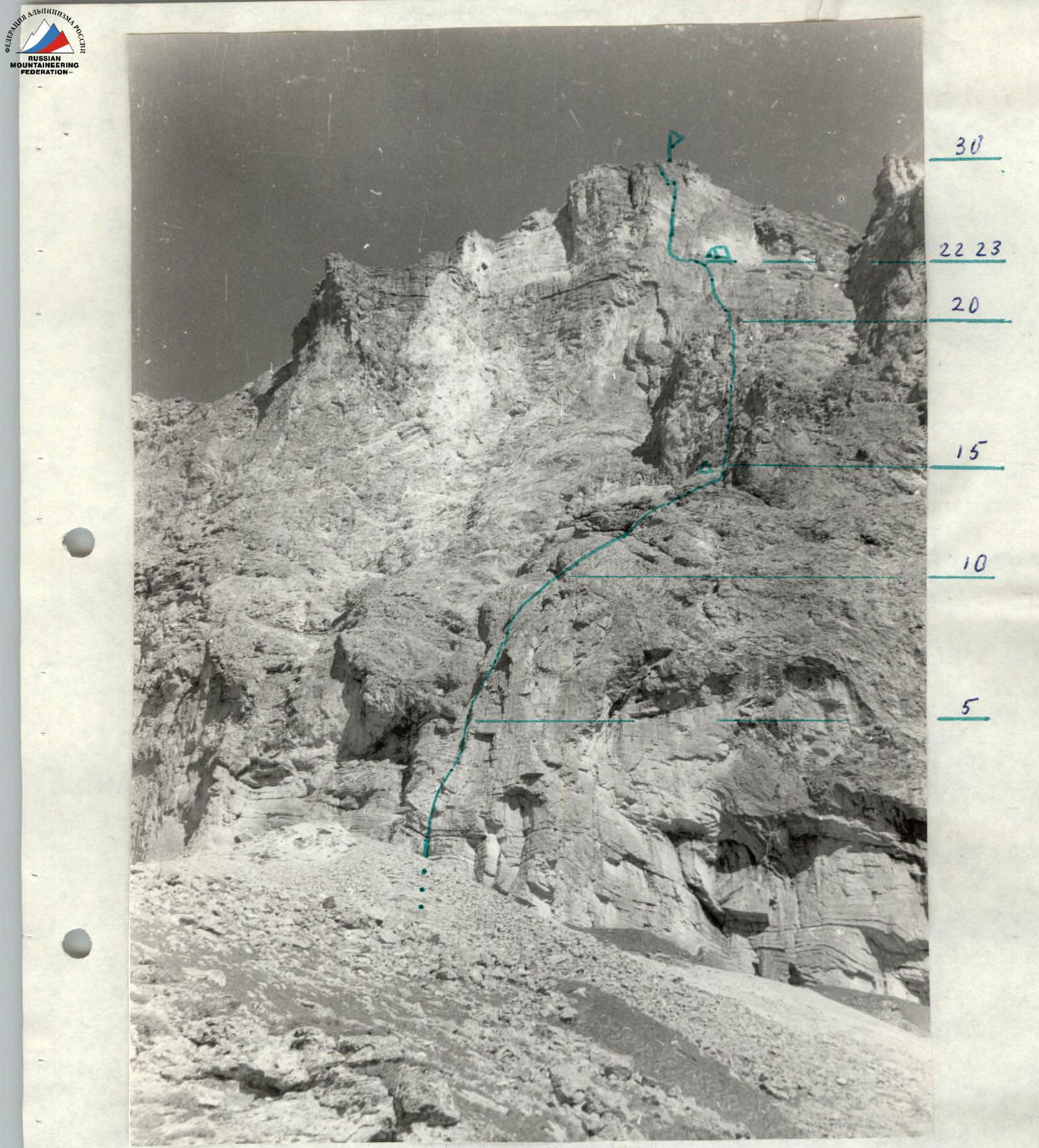
Explanation of the table and route description
The route consists of: a) a lower section with a steepness of about 80°, extending 100–120 m. This section is composed of massive, relatively monolithic limestones, abundant with overhangs and internal corners. The key sections of the lower part are R2–R3, R5–R6; R8–R9. Particularly difficult and dangerous is the R5–R6 section, which is a sheer internal corner with huge 1–2 m boulders jammed within it.
Further sections, R10–R14, represent a steep ridge of the buttress, interrupted by smoothed walls 5–10 m high. The steepness of this ridge is approximately 65°.
Starting from section R16, the route becomes a sheer wall with a steepness of more than 85°, composed of layered limestones. Immediately, difficulties arise with organizing belays since vertical cracks are absent, and horizontal ones are wide and blunt. This section is much more broken. Movement is directed right and upwards; to the left lies a sheer wall with an oblique overhang. Climbing is extremely challenging. After 3.5 pitches, having passed a system of sheer internal corners with overhangs, the climbers reach a ledge. The ledge is a recess in the sheer wall, 1.5–2 m wide in some places. It tapers out to the left. The ledge provides a spot for a bivouac. A very difficult 30-meter traverse leads to the base of a "sickle" — a not clearly defined internal corner with an overhang (section R23–R24). Movement is along the corner, then following its direction right and upwards, and after one pitch, left. Organizing belays is extremely difficult. Steepness is 90°. All climbing is at the limit, free climbing, and thus rarely used.
Overhang. The rock structure is such that chocks don't fit. After 2.5 pitches (section R27), the steepness decreases to approximately 80°, and the rocks become even more broken. A traverse to the left and up a broken internal corner leads to a point slightly right of the summit (10–15 m). Descent from the summit along the ridge, traversing the entire massif, takes 2.5–3 hours to reach a narrow canyon. From there, it takes 3–3.5 hours to reach the geologists' camp via the Dumala pass.
Observation
The team's observer was stationed at a camp near a spring. They were equipped with a radio station, 8x binoculars, and a 20x telescope. However, weather conditions made visual observation practically impossible. According to the radio schedule, they maintained radio contact with the group at 8:00, 11:00, 14:00, 17:00, and 20:00.
General view of the peak

Table of main route characteristics
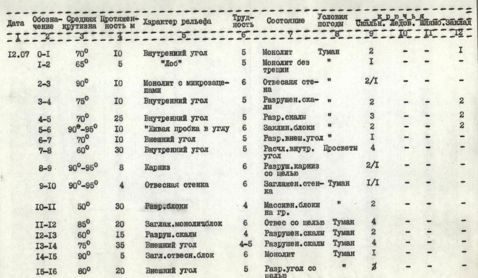

The ledge is 1.5–2 m wide, where a semi-reclined bivouac is organized. July 12. Work began at 4:30, and they worked until 17:00 on that day. An additional section, R22–R23, was processed until 19:00. Climbing hours totaled 12.5. 2 pitons were hammered, including 5 for I.T.O. 9 chocks were used.
 July 13:
| Designation | Average steepness | Length, m | Relief characteristics | Difficulty | Condition | Weather conditions | Pitons (rock / boulder / chocks) |
|---|---|---|---|---|---|---|---|
| R29–R30 | 80° | 10 | Broken internal corner, transitioning to a chimney | 5 | Broken rocks | Fog | 1 / – / – |
Reached the summit at 15:00. Worked from 7:15 to 15:00 on that day. Climbing hours totaled 8. 37 pitons were hammered, including 4 for I.T.O.
Team captain
S.S. Tyulpanov
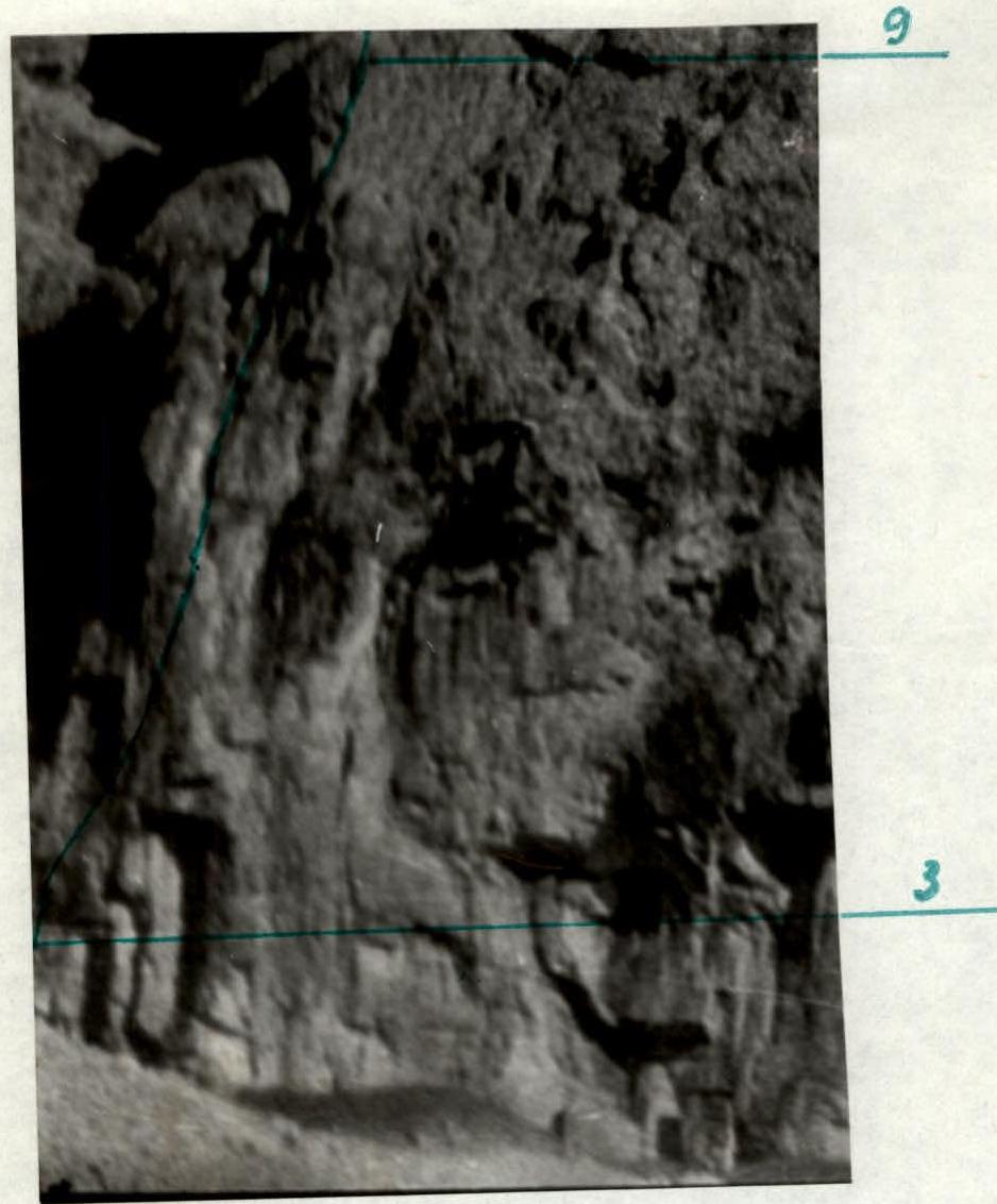
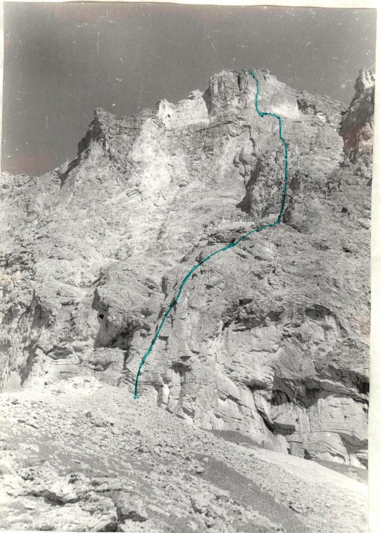
Lower part of the route. Sections R3 to R9. Shot with MTO-500 telephoto lens. Path of the cracks group.
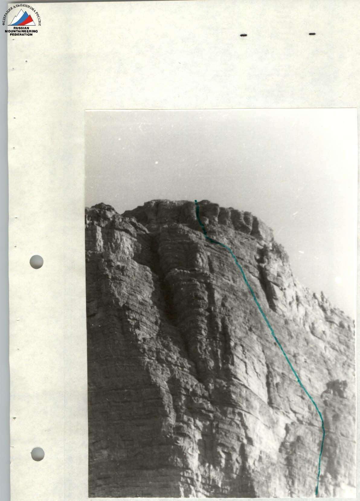
Upper part of the route. Sections R24 to R30. Shot with MTO-500 telephoto lens. Path of the training group.
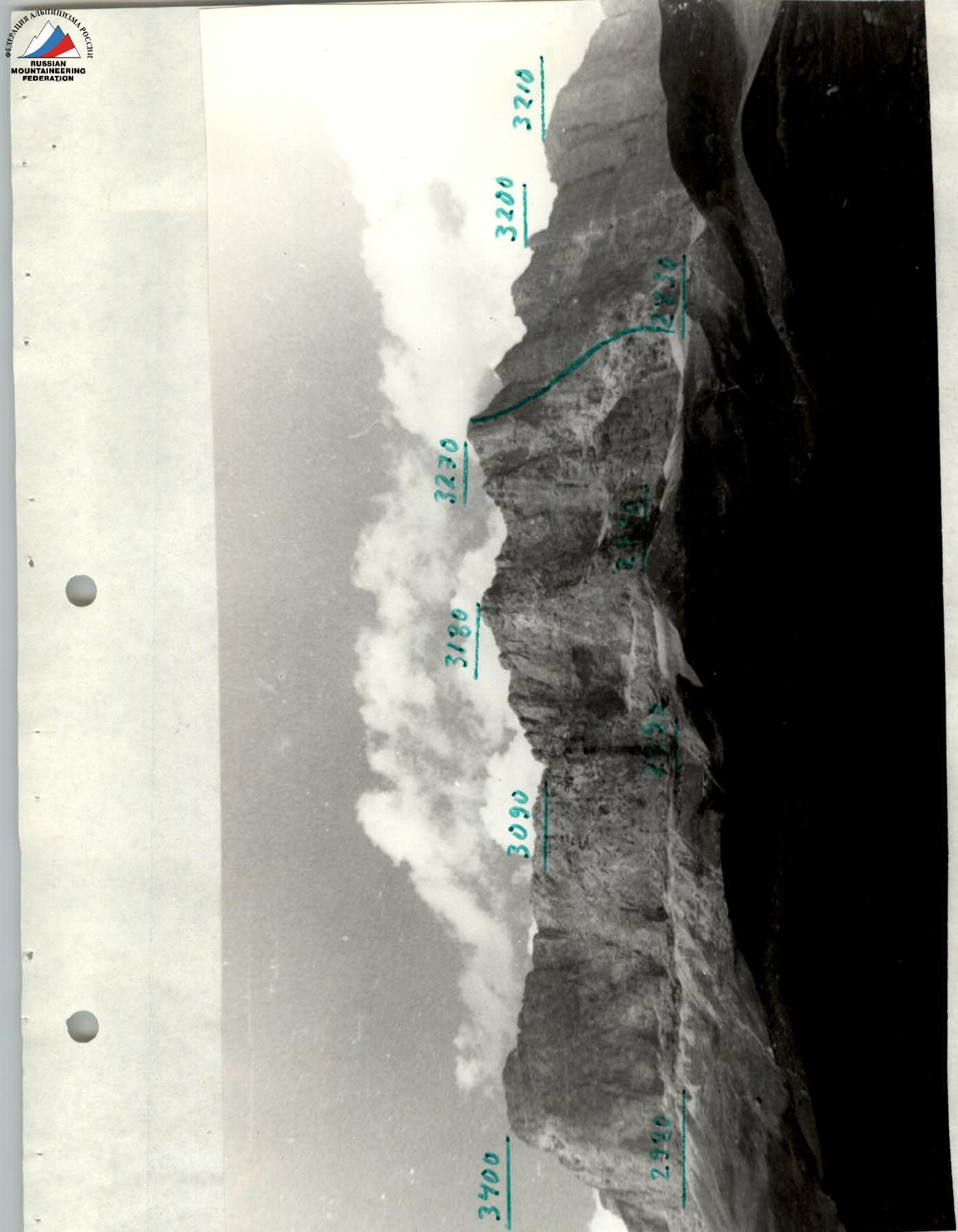
General panorama of the massif with altitude marks. Taken from a 1:10,000 topographic map — path of the group.
Debriefing Protocol No. 3
Ascent by the team of the All-Union School of Alpinism Instructors of the All-Union Central Council of Trade Unions: Ak-Kaya Massif, Central peak via the South buttress
July 15, 1979
Debriefing conducted by Honored Coach of the RSFSR — Zhirnov V.V.
Present:
- Team in full composition
- Coach, Master of Sports of the USSR — Zhirnov V.V.
- Authorized representative of the USSR Sports Committee — Chereshkin D.S.
- Judge-curator — Shalayev G.I.
- Observer — Guryan Yu.A. (1st sports category)
- Judges:
- Levin M.S.
- Zemerov V.I.
- Secretary — Gurevich Ya.V.
Tyulpanov S.S.: "Preparation for the championship began long before arriving in the mountains, from the moment we received a spot in the rock climbing category. We prepared: a) special lightweight equipment for the rock climbing category — backpacks, down vests instead of heavy down jackets, "legs", special rock pitons for broken rock, etc. b) individual training plans at our place of residence — Andreyev L.A. trained in the Skalisty Ridge near Tyrny-Auz, Volkov V.T. climbed in Crimea in May, Tyulpanov S.S. and Stepanov E.P. focused on climbing with bottom belay. Joint training in the mountains included ascents of 3A, 4A, 5A categories and 6B category (Krumkol). After this, the final team composition was formed. c) We selected high-calorie food products while still at home. The school doctor helped us assemble a set of tools to ensure high performance on the route. d) Information: Letter from the judging panel, observation from the "Bezenge" settlement. On July 6, the team arrived at the geologists' settlement and immediately conducted reconnaissance and photography. On July 9, we obtained photographs. We received information from geologists about the structure of the rocks, learned that the wall has two belts: the lower one is made of massive limestones, and the upper one is made of layered rocks. We studied data from aerial photography and amateur photos.
We chose two options — the final one was the ascent to the Central peak of the Ak-Kaya massif via the South buttress.
The gullies on both sides of the chosen buttress are rockfall-prone; based on the location of scree, visual observation, and listening, we were convinced of the safety of the route along the buttress. Tactical plan:
- July 10 — additional reconnaissance;
- July 11 — start the ascent, determine the observer's location, and set up an "NP" near the spring, carrying part of the equipment under the route (50 minutes walk from "NP");
- July 12 — start the route, aiming for bivouac "R20" and processing until "R22". As a result of additional observations, we abandoned the use of hammocks;
- July 13 — reach the summit from the bivouac;
- July 14 — descend and return to the geologists' camp.
We executed the plan. Changes: bivouac was higher than planned at "R22" (about 14 hours from the start of the route), which allowed us to reach the summit on July 13 and return to the camp on the same day.
We took: 4 ropes of 40 m each, 50 carabiners, 40 pitons, "Meta" stove, food: 0.2 kg × 4 people × 2 days = 1.6 kg. Water — 9 l (5 l were discarded for weight reduction at 12:00 on July 12, as it was overcast and damp on the route). Special equipment: jumar ascenders, ladders, etc. Backpack weight did not exceed 6 kg, allowing us to avoid pulling them up.
Tactics included:
- frequent change of lead climber to maintain a high speed;
- the first climber always used a double rope, ensuring both safety and high speed;
- the last climber had a hammer-piton remover, increasing the speed of piton removal;
- fixed ropes were secured to at least two pitons, and the second climber in the first rope made additional securing on intermediate pitons.
Departure from the initial bivouac on July 12 at 2:50, started climbing at 4:30. The first three pitches were climbed by the Volkov-Andreyev rope pair, with Volkov leading. The rock was complex, particularly challenging was navigating an overhang with an internal corner and a "live" plug. After four pitches, they reached the ridge of the buttress. Then, the Tyulpanov-Stepanov rope pair took the lead, with Tyulpanov leading. Visibility was 5–10 m; they followed the protruding parts of the buttress to avoid entering rockfall-prone gullies. Approximately four pitches. Then, the Andreyev-Volkov rope pair took the lead, with Andreyev leading. The rock structure changed; the rocks became layered with horizontal cracks. It started raining. After two challenging pitches, they reached a ledge under a hanging pre-summit tower at 17:00, where they decided to set up a bivouac. The pair traversed difficult rocks and approached an internal corner, which was very dangerous due to its brittle, broken, and hanging rocks. They found a unique solution to ascend to the summit via a sickle-shaped overhang on the right side of the tower. They stopped working at 19:00 and settled in for the night. It rained during the night. The bivouac was semi-reclined.
On July 13, they started working at 7:15. Extremely challenging climbing. All holds were "reverse"; the tower was overhanging. The first rope pair, Andreyev-Stepanov, led, with Andreyev working first — 2.5 pitches. On these pitches, they hammered the only boulder piton on the route and used I.T.O. several times. Then, Stepanov led. At 11:00, the observer from the "Baksan" alpine camp reported their location via radio, with an error of about 100 m (confused the left edge with the right). I had to correct this via radio. Then, Stepanov led on section R27. At 15:00, the entire group reached the summit.
Route characteristics: A total of 102 pitons were hammered on the route, including 11 for I.T.O. 9 chocks and one boulder piton were used. Regular pitons didn't go in well; only tubular pitons made of soft titanium were hammered successfully. Height difference is 440 m (according to topography, 420–460 m). Overall steepness of the route is 73°, with a total length of 550 m including traverses. The route is bounded by rockfall-prone gullies, logical, and deviation from the route is impossible. Half of the route corresponds to sections of the 6th category of difficulty. The route resembles the summit tower of Mirali peak. In terms of brokenness, it is similar to routes in the Fann Mountains and Archa-Kanysh. The group believes the route can be classified as 5B category.
The ascent was complicated by bad weather — the rocks were wet. Comparing it with six routes of 6B category difficulty that I've climbed, I can say that besides the challenging climbing, additional difficulty came from the complexity of organizing additional belays. But we had a diverse set of pitons, which helped us.
Characteristics of participants:
- Andreyev A. — very good at leading on unpleasant, difficult rocks where it's hard to organize belays.
- Volkov V.T. — a good, experienced rock climber — Candidate Master of Sports in rock climbing.
- Stepanov E.P. — calm, friendly, well physically and technically prepared athlete.
Radio communication was generally successful despite the observer's radio failing. They communicated with us through a "VP-3" radio.
Zhirnov V.V.: "Any questions?"
Chereshkin D.S.: "Is the nature of the route similar to the team from Kyrgyzstan?"
Tyulpanov S.S.: "Our lower section is very steep, about 3.5 pitches, then a slight easing, and the top is overhanging for about three pitches."
Shalayev G.I.: "What was the visibility like on July 13?"
Tyulpanov S.S.: "The lower part of the route was always shrouded in fog, and only occasionally did the left part clear up."
Participants' statements: Stepanov E.: "The route was very carefully studied in terms of rockfall danger. Rocks didn't fall along the route. The captain did a huge amount of preparatory and organizational work, and there was a good democratic spirit within the team. No one experienced psychological or physical overload on the route."
Volkov V.T.: "We very successfully chose the path at the top, largely thanks to Andreyev A.'s efforts."
Andreyev A.: "The rocks were unfamiliar to me, and a lot of attention was given to 'blacksmithing': not thin pitons, but channels and tubes; many 'dull' gaps. Climbing was very demanding, especially on overhanging sections. The route is tough, with hard climbing."
Judge Shalayev G.I.: "I was appointed judge for this route." Weather conditions affected observations — I couldn't observe much; during clearings, I was under the second route. The observer from the "Baksan" alpine camp, Ivanov (3rd sports category), reported seeing the group on the route from 10:05 to 10:35 on July 13; he saw the first climber in a blue windbreaker: a white rope is coming from him — further, a red one. The observer believes the first climber was on a single rope."
Tyulpanov S.S.: "This was on a key section of the route (about 400 m from the foot of the wall). I think the observer just didn't see the yellow rope (presents the rope)."
Shalayev G.I.: "What criteria do you use to characterize sections of the 6th category of difficulty?"
Tyulpanov S.S.: "I have climbed six 6th category routes, Andreyev A. has three, Stepanov E. has two, and Volkov V. has one. Comparing with other 6th category routes: extreme climbing with poor possibilities for organizing belays. By I.T.O., we mean not just ladders but also support points. I can compare it with classified 6th category routes in the Fann Mountains."
Levin M.S.: "Do you have experience climbing in Crimea and around Zaamin-Karora?"
Volkov V.: "It's harder than 5th category routes on Ai-Petri, Kilve-Burun by two variants, Sokol, and much longer. I've climbed them myself and compared with others' assessments. The steepness is the same."
Tyulpanov S.S.: "The team hasn't done ascents around Zaamin-Karora."
Zhirnov V.V.:
- "I'm working with the team for the first time; preparation was very serious, everything was considered.
- Changing the route to reach the tower was a mature decision.
- It wasn't a deviation from the route; the team stayed within the planned corridor.
- Route assessment is 5B category complexity.
- The group's behavior on the route was correct.
- I'm counting the ascent and leadership."
| Coach | Zhirnov V.V. |
|---|---|
| Secretary | Gurevich Ya.V. |
"Correct"