North Elbrus Region
REPORT ON THE FIRST ASCENT OF THE ALPINISM ROUTE TO PEAK 3060 (Korona Z.) TASHLYSYRT RIDGE September 20, 2020
V. TRETYAKOV YESSENTUKI APRIL 2021
Peak 3060 (Korona Z.) Route: via the western ridge Complexity category: 1B category (rocky) Leader: V. Tretyakov
Location:
- Central Caucasus
- North Elbrus Region
- Jilyasu area
- Kyzylkol valley
- Tashlysyrt ridge
Section in KMGV – 2.4. E-mail: agblpcy@list.ru
Report
On the first ascent of the alpine route to peak 3060 (Korona Z.) as part of the mountain training program of the Educational and Rescue Center of the North Caucasian Regional Rescue Service of the Ministry of Emergency Situations of Russia in September 2020.
Route: via the western ridge
Complexity category – (approximately) 1B, rocky
Region: Kabardino-Balkar Republic
Mountain country: Central Caucasus
Gorge: North Elbrus Region, Jilyasu area, Kyzylkol river valley
Ridge: Tashlysyrt
Peak: 3060 (Korona Z.), [Korona Z. massif (3060) – V. (3111)]
Route: via the western ridge
Complexity category: 1B (approximately), (rocky)
Prepared by: V. Tretyakov
January 2021
Kyzylkol River Valley
The Kyzylkol river valley is located under the northern slopes of Mt. Elbrus. From the north, it is bounded by the Tashlysyrt ridge, which has a latitudinal orientation from peak Kyzylkaya (3638) to peak Sirkh (3098). From the west, it is bounded by a spur of Elbrus with the Buruktysh pass (Burukdash). To the east, the Kyzylkol river drops off with a waterfall into the Jilyasu tract and, merging with other flows from Elbrus glaciers, forms the Malka river.
The peaks of the Tashlysyrt ridge have height marks, and Kyzylkaya, Tashlysyrt, and Sirkh have names on the maps of the Department of Cartography and Geodesy of the Russian Federation and the maps of the General Staff of the Russian Federation. Peaks 3243 and 3111 do not have official names: conventional alpine and local names "Chyorny khrebet" and "Korona massif" are given for identification of the peaks.
Object of Ascent
The section of the ridge from peak Tashlysyrt (3464) to peak 3111 is a rocky, jagged ridge massif, representing interest in the alpine context for training and acclimatization ascents. Since there is a seasonal emergency services post of the Ministry of Emergency Situations of Russia near the Emanuela clearing, and among the classified routes, only Elbrus and Balyksu-bashi, an attempt was made to develop nearby peaks for training purposes for rescuers of the Ministry of Emergency Situations and other climbers in the northern Elbrus region.
The group "Mountain Training" of the Educational Center of the North Caucasian Regional Rescue Service of the Ministry of Emergency Situations of Russia was formed in 2020 from rescuers from different regions of Russia (Baikal, Nizhny Novgorod, Moscow, Sochi, etc.). Due to time constraints and the need to complete the training program, as well as the lack of acclimatization, they did not have time to climb Elbrus.
According to available information, the routes to peaks 3243 and 3111 from the west were evaluated as 2B, 2A category.
The route passed by A. Donskov to peak 3111 (Korona V.) from the east turned out to be too simple and did not reach 1B.
It was decided to make a traverse of the Korona massif from the west. The most optimal and safe ascent to the ridge crest of Tashlysyrt goes along a gentle grassy southern rib between peaks 3243 and the Korona massif.
Initially, it was planned to make a traverse of the Korona massif from west to east, but during the ascent to Korona Z. (3060), it was decided to limit oneself to one peak, since 1B was already achieved, and the further section was estimated (approximately) at the second category of complexity. The group consisted of beginners, and for the first ascent, this would be challenging.
The passed route can be compared to 1B on Gumachi or Skala Orlyonok (in Arkhyz, route Sputnik) and is technically a bit simpler than the eastern route to Irikchat V.
Fragment of the map of the Department of Geodesy and Cartography of the Russian Federation scale 1:200,000 (grid cell 4 × 4 km)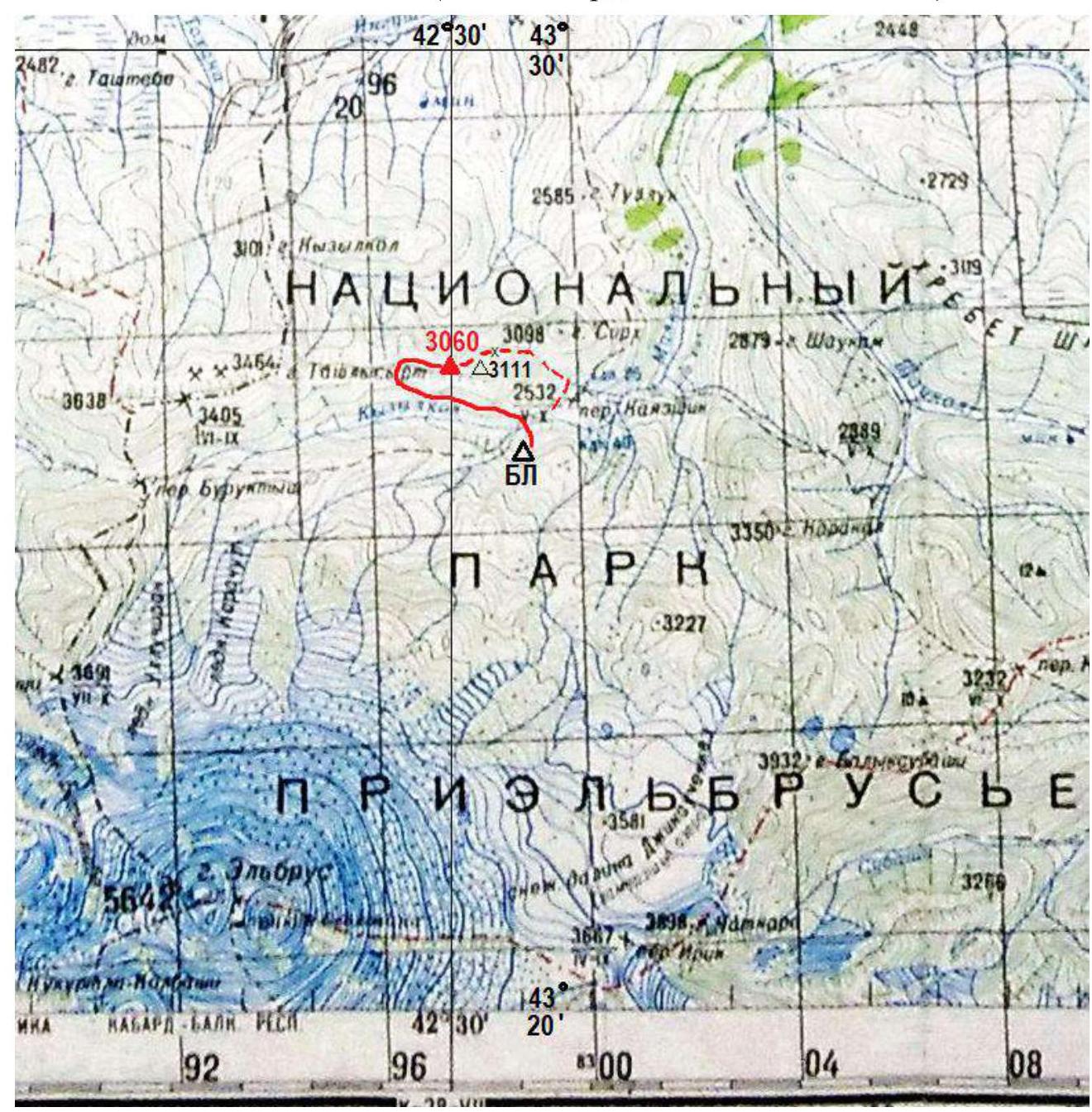
Route on the satellite image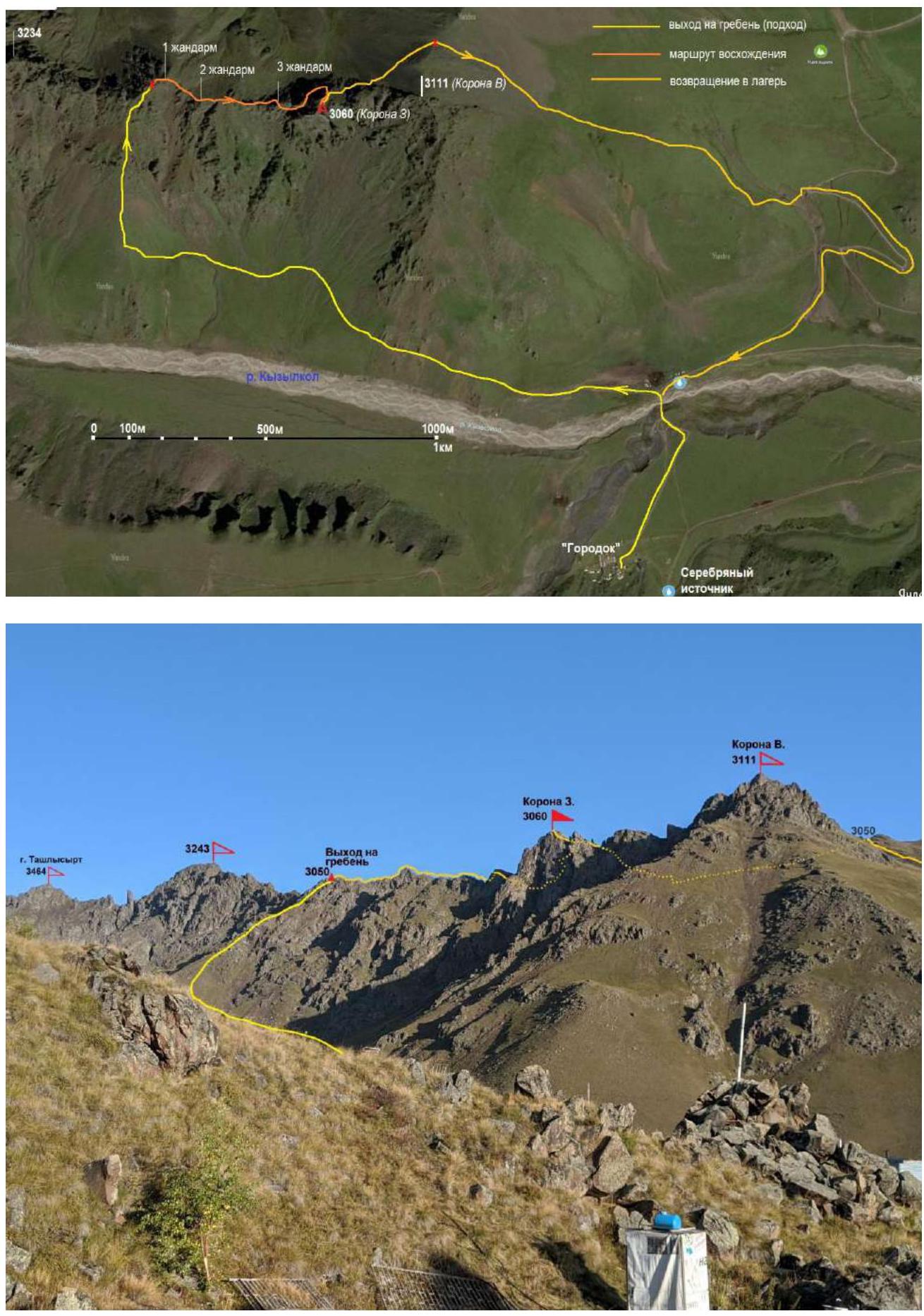
Overview photo (1) of the rocky part of the Tashlysyrt ridge. View from the base camp
Overview photo (2), view of the Tashlysyrt ridge from the side of the "Stone mushrooms"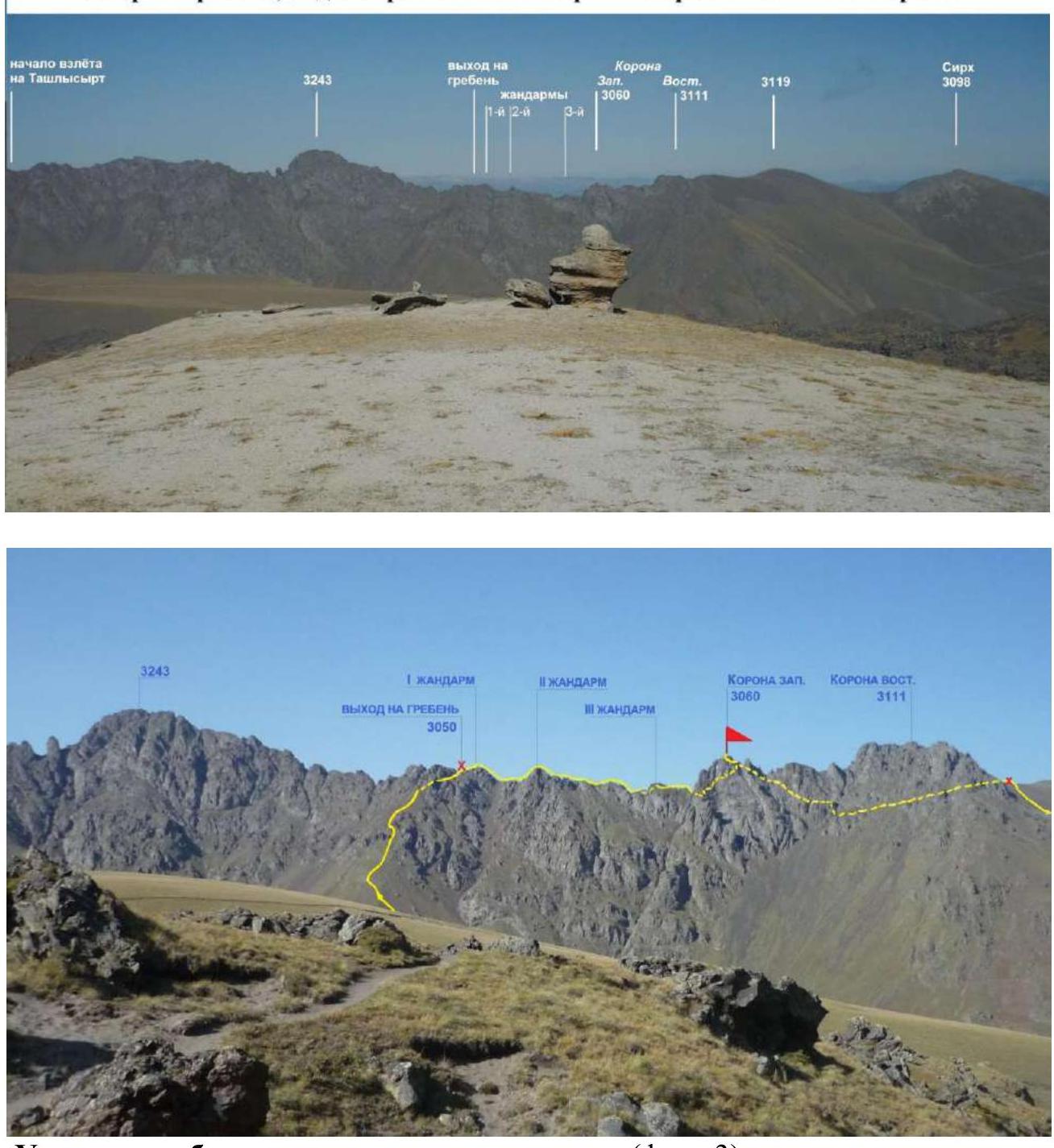
Section of the ridge with the ascent route (photo 3)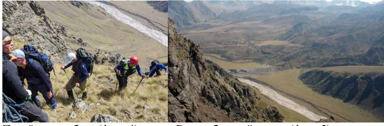
Ascent to the ridge (photo 4). View of the base camp (photo 5)
Passport
Ascent to peak 3060 (Korona Z.) via the western ridge
- Section number according to KMGV – 2013 – 2.4. Central Caucasus, mountain region – North Elbrus Region, Jilyasu area, Kyzylkol river valley, northern spur of Elbrus – Tashlysyrt ridge, Korona massif
- Name of the peak: 3060 (Korona Z.). Coordinates: 43°26′40″N, 42°30′00″E
- Height: 3060 m (according to GPS)
- Route: via the western ridge
- Complexity category: approximately 1B category
- Route character – rocky, ridge
- Height difference of the route: From the base camp on the Emanuela clearing – 520 m
- Route length: Total length (from the base camp) – 3800 m. Technical part (from R0 – exit to the ridge crest) – 720 m.
- Length of sections with the highest category: 1 category – four sections – 300 m, 2 category – six sections – 200 m, 3 category – three sections – 15 m, 4 category – none – 0 m, 5 category – none – 0 m, 6 category – none – 0 m.
- Average steepness: entire route – 8°, exit to the ridge – 18°, technical part (peak ascent) – 37°.
- Hooks used: Total used on the route: rock hooks – 0, chocks – 4, protection loops – 9, stationary pitons – 0, IT – 0, removable pitons – 0. Hooks left on the route: total – 0; including pitons – 0; rappel loop – 1.
- Exit to the route (from the base camp) – 8:30, September 20, 2020. Exit to the peak – 16:00, September 20, 2020. Return – 18:30, September 20, 2020.
- Team hours: – 10 hours.
- Leader: Tretyakov V. Ya. (Yessentuki, CMS, instructor-methodologist 2nd category), Participants: Golubov Vitaly Nikolaevich (Krasnodar PDS), Evdokimov Vladimir Sergeevich (Krasnodar PDS), Gorobets Andrey Alekseevich (Krasnodar PDS), Korzun Sergey Vitalievich (Krasnodar PDS), Karamzin Artem Igorevich (Povolzhsky RPS), Martynov Dmitry Vyacheslavovich (Kazan PDS), Nedorezov Sergey Sergeevich (Baikal PDS), Serba Denis Konstantinovich (Stavropol PDS), Ustyak Roman Igorevich (Saransk PDS).
- Coach: Tretyakov Vladimir Yakovlevich (CMS, instructor-methodologist 2nd category), instructor of the Educational and Rescue Center of the North Caucasian Regional PDS of the Ministry of Emergency Situations of Russia.
Analogous routes:
- Gumachi – 1B (Adyl-Su);
- Sk. Orlyonok (route Sputnik) – 1B (Arkhyz);
- Irikchat V. from pass Irik – 1B.
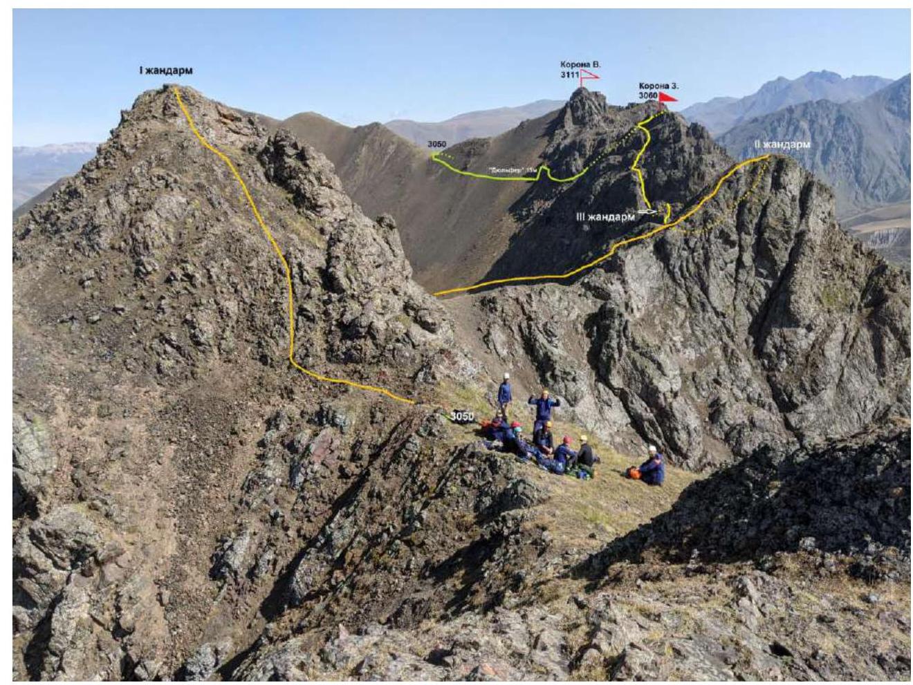
Ascent to the Tashlysyrt ridge crest. View to the east on "Korona". (Photo 6).
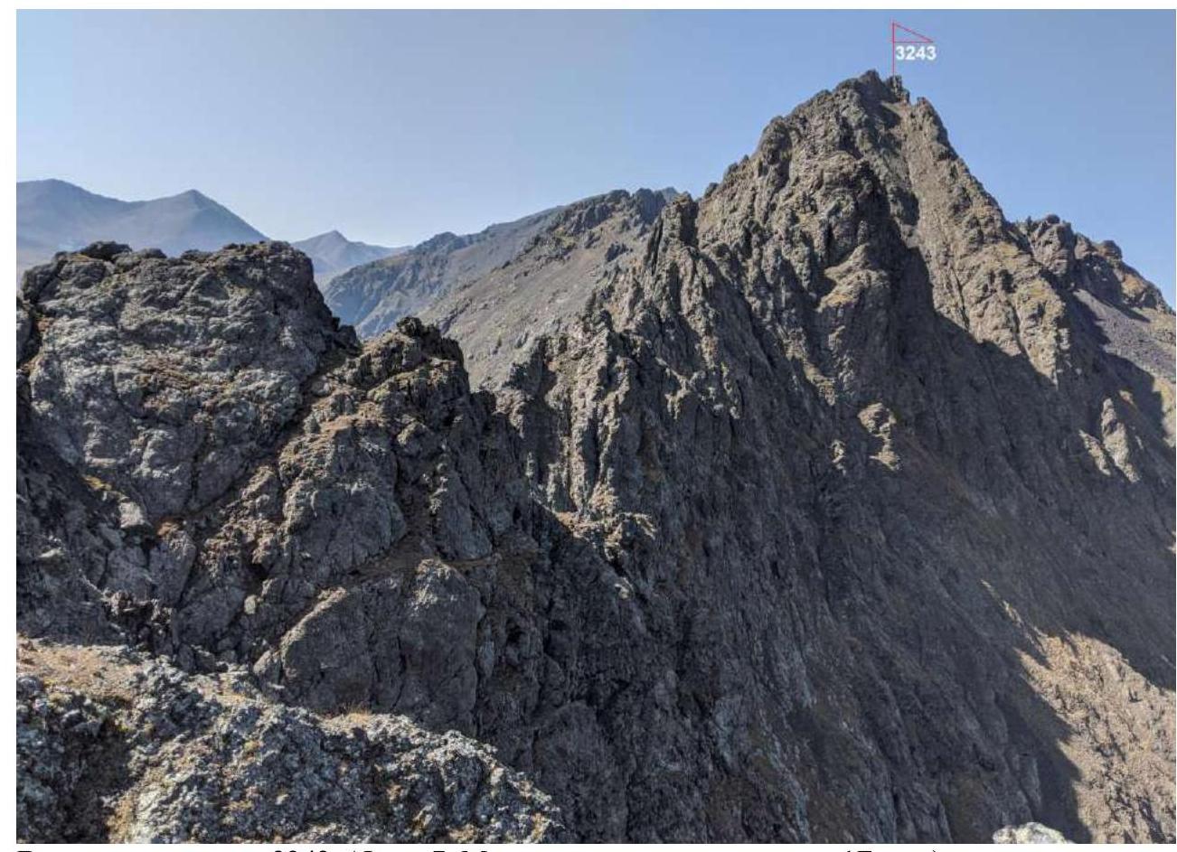
View to the west on peak 3243. (Photo 7. The route is clearly more complex than 1B category.)
Description of the Peak
Peak 3060 (Korona Z.) is located in the rocky Korona massif, situated in the middle part of the Tashlysyrt ridge, between peaks Tashlysyrt (3464) and Sirkh (3098). The peak is not marked on the map M 1:100,000 of the General Staff of the Russian Federation with a height mark, so the height is determined by an altimeter and checked against the contour lines of the geodetic map M 1:25,000. The same map has a mark for peak 3111 (Korona V.). The name "Korona massif" is unofficial, given for identification of the peaks, accepted among the inhabitants of the "City" of base camps of various tour firms on the Emanuela clearing.
Peak 3060 (Korona Z.) from the Kyzylkol river valley is easily identifiable from the camp as the left mountain in the Korona massif, with a pronounced ridge and rocky tower. (See photo 1).
Description of the Route
Route: "Via the western ridge" – a characteristic training rocky route of 1B complexity category, with a full set of natural obstacles corresponding to routes of this level. The most optimal exit to the western ridge of Korona (as well as to the eastern peak 3243) is easily determined and simple, as the only gentle grassy southern rib between these peaks. The route is logical, from the ascent to the ridge and to the peak, there are no problems with orientation.
Equipment
To make the ascent as part of a detachment of 10 people on the route, the following special equipment is necessary:
- Personal — standard issue;
- Public: main rope – 4 × 50 m, rock hammer – 2 pcs., rock hooks – 6–8 pcs. (for training in driving and extracting. The nature of the relief allows the use of chocks and loops), chocks – 1 set. Friends – 0 pcs. Ice screws – 0 pcs. Quickdraws – 5 pcs. Loops – 4–6 pcs. Section of expendable rope for rappel loop.
Approach
From the base camp of the Ministry of Emergency Situations on the Emanuela clearing, cross to the left bank of the Kyzylkol river in the area of the koshev and follow the trail, which gradually rises upward, about 1.5 km, in the direction of the gentle grassy rib. Along it, bypassing the rocky sections on the right, exit to the saddle of the ridge between two gendarmes. On the saddle, it is convenient to organize teams. The approach takes 2 hours 30 minutes (Photo 1, 3, 4, 6).
Technical Part
The route begins with a simple ascent to the right (eastern) 1st gendarme. From it, a 50 m descent via rappel to the ridge, along which we approach the 2nd gendarme. Along simple rocks, with insurance, a 50 m exit to it and a 30 m rappel descent to the ridge. Further along the ridge, with simultaneous insurance, in the direction of the large rocky 3rd gendarme about 4 ropes.
To the 3rd gendarme with alternate insurance on the left side of the ridge 30 m to the ledge behind the flake. Station. Along the ledge, we move to the right side of the gendarme and along the ledges on the right side of the gendarme, we rise 40 m to the ridge behind it. Station. The bypass is carried out with alternate insurance, using ledges and large stone blocks of natural relief for intermediate points. Further along the ridge, simultaneously – 2 ropes and a simple 30 m descent to the peak of the couloir, separating the peak tower from the western ridge.
The key to the route is the ascent to the peak tower. From the couloir, along a simple 4-meter wall, exit to an inclined ledge. From it, along the left side of a large-block wall (key section), then simple rocks exit to the shoulder of the rib. From the couloir 50 m.
Then, bypassing the smoothed rocks of the internal angle on the right, exit to the saddle of the peak rib (30 m). Along simple rocks, between the peak tower and a small gendarme, climb to the peak ridge and along it to the peak. From the exit to the saddle to the peak about 30 m of simple climbing.
Peak 3060 m (Korona Z.) is tower-like, clearly expressed. The tour was set by the participants of the first ascent of the route. From the peak to the west opens a panorama of the peaks of the Tashlysyrt ridge: 3243, Tashlysyrt, Kyzylkaya, and on the right, Kyzylkol. To the east, the peaks of Korona V. and Sirkh block the view, and to the south, directly opposite, the Elbrus massif.
Descent. From the peak, return to the saddle of the rib. From it to the right, along goat trails, descend to a wide scree couloir and along it down to a wide ledge on the right. Along the ledge, traverse to simple rocks, insurance through ledges. From the peak about 150 m. When 15 m remain to the slope, on one of the rocky ledges, a rappel loop is organized, and from it, a descent to the scree slope. (You can descend along the couloir to the slope, but then the ascent to the saddle of the ridge will be 40–50 m higher). Along the slope, with a small gain in height, exit to the saddle of the ridge between Korona V. and the ridge of peak Sirkh 250–300 m. From the saddle, down the slope to the road leading to the Emanuela clearing in the camp about 3 km. The descent towards the camp, to the upper koshev, is shorter by 1 km, but the steepness is about 30°.
Recommendations to the Instructor
Due to the accessibility of the route in terms of orientation, it can be recommended for both training detachments (level 1, 2) and for independent sports groups (level 1, 2) making training or acclimatization ascents.
Time to complete the route:
- For training detachments (level 1, 2) – 8–10 hours;
- For detachments of intermediate level (level 1, 2) – 6–7 hours.
Table of Natural Obstacles of the Route
Tashlysyrt ridge, northern spur of Elbrus. Jily-Su tract, Kyzylkol river valley. Peak 3060 (Korona Z.). Route: via the western ridge. Category: 1B, rocky (approximately).
| Characteristics of sections | Length | Steepness | Complexity | Notes |
|---|---|---|---|---|
| APPROACH. From the base camp of the Ministry of Emergency Situations on the Emanuela clearing to the Kyzylkol river. Then ascent along the southern slope of the Tashlysyrt ridge to its southern grassy rib. Along it, ascent to the ridge crest. Height difference: bridge over the Kyzylkol river at 2530 m, saddle of the ridge at 3050 m – total 520 m. Ascent takes 2–2.5 hours. Place of organization of teams – saddle of the ridge (3050 m). R0 | ||||
| R0–R1. Approach to the 2nd gendarme. Ascent to the 1st gendarme 30 m. Rappel descent 50 m. + Flat ridge. | 130 | 30–45° | 1, 2 (50 m) | Used: Loop on a ledge – 1, hooks/chocks: 0/0. Hooks and chocks not left |
| R1–R2. Exit to the 2nd gendarme. Monolithic ridge. Movement: leader with lower insurance, others on perches. | 50 | Up to 30° | 1+ | Used: hooks/chocks: 0/0. Hooks and chocks not left |
| R2–R3. Descent from the gendarme and approach to the 3rd gendarme. Interaction of teams. Descent 30 m with insurance, along the ridge – simultaneously. | 230 | 35° | 1+, 2 (30 m) | Used: loops – 2, hooks/chocks: 0/0. Hooks and chocks not left |
| R3–R4. Ascent to the 3rd gendarme. Along the ledge on the left of the ridge, with exit to the right along the internal angle to the ridge. Further to the left to the rocky ridge and along it to the right to the flake. Behind it on the ledge is a station. | 30 | 30–50° | 2+, 3 (5 m) | Used: loops – 2, hooks/chocks: 0/1. Hooks and chocks not left |
| R4–R5. Approach to the peak tower. To the right along the ledges, above the couloir, exit 40 m to the ridge. Along it, two ropes and descent to the right to the peak of the narrow scree couloir 30 m. | 170 | 5–20° | 1+ | Used: loops – 1, hooks/chocks: 0/0. Hooks and chocks not left |
| R5–R6. Exit to the shoulder of the counterfort. Key to the route. From the couloir, along a simple 4-meter wall, exit to a ledge of the rocky couloir. Along the left side of a large-block 6-meter wall, key, then along simple rocks, exit to the shoulder. | 50 | 45°, walls – 70° | 2, 3 (4+6 m) | Used: loops – 1, hooks/chocks: 0/2. Hooks and chocks not left |
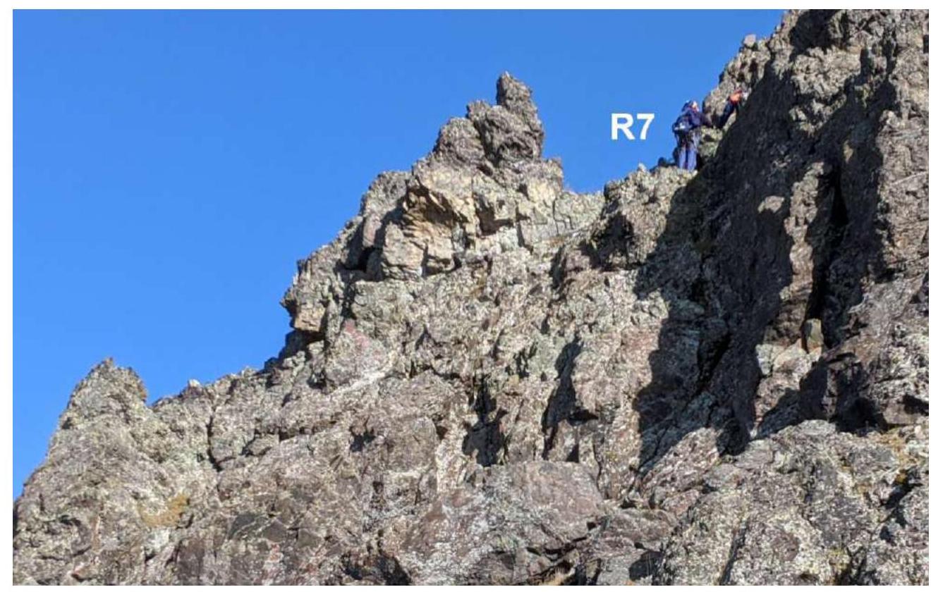
| R6–R7. Exit to the peak rib. From the shoulder to the right, towards the rocky saddle, bypassing the large internal angle under it on the right. Along the crack, climb to the ledge and traverse to the left to exit to the saddle. | 30 | 40° | 2, 2+ | Used: loops – 2, hooks/chocks: 0/0. Hooks and chocks not left |
| R7–R8. Exit to the peak. From the saddle, along simple rocks, bypassing the peak tower on the left, climb to the peak. | 30 | 35–40° | 2+ | Used: loops – 1, hooks/chocks: 0/1. Hooks and chocks not left |
| DESCENT. From the peak to the saddle of the rib R7. From it to the right, descent to a wide scree couloir. Along the couloir to a wide ledge on the right. Along it, and further along simple rocks – traverse of the northern slope to the right to complex rocks. From the peak about 150 m "Dulfer" 12–15 m to the northwestern scree slope, along which – exit to the saddle of the ridge. From it – descent to the road to the Emanuela clearing. |
Total:
Route Length
(without approach from R0) – 715 m
Height Difference:
From the base camp – 520 m. From R5 to the peak – 80 m. The ridge crest from R0 (3050 m) to R5 (base of the peak tower – 2980 m) gradually decreases with ascents to the gendarmes.
Average Steepness:
entire route – 8°, ascent to the ridge – 18°, technical part – peak ascent 40°.
Technical Sections:
1 category – four sections – 300 m, 2 category – six sections – 200 m, 3 category – three sections – 15 m.
Used/Left:
Hooks – 0/0 pcs., Chocks – 4/0 pcs., Loops on ledges – 10/1 pc. (rappel).
Fragment of topographic map 1:25,000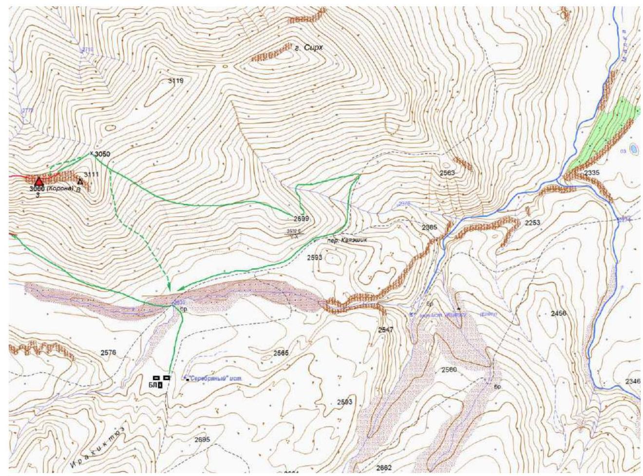
Dotted lines show possible descent options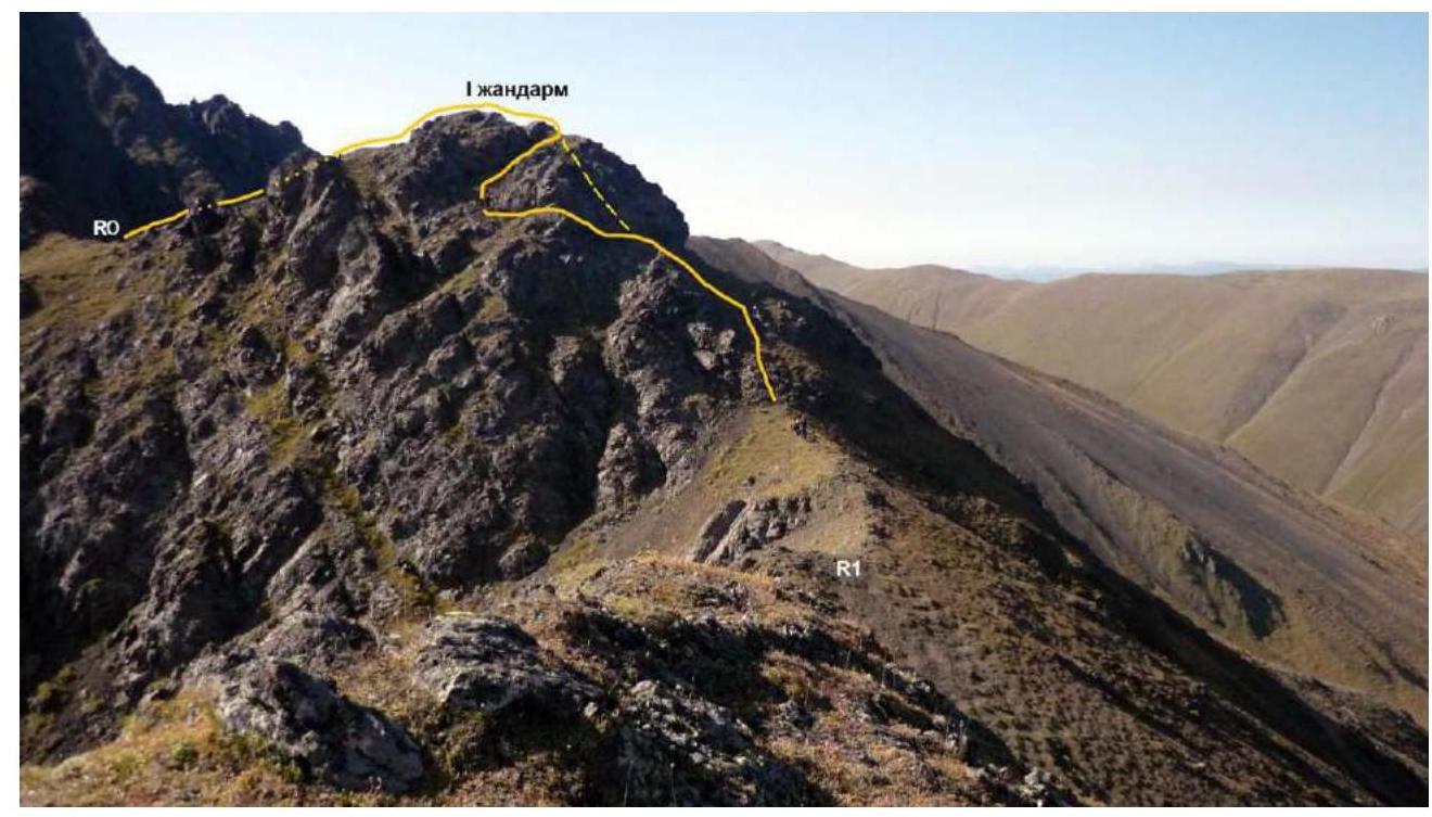
Section R0–R1. Descent from the 1st gendarme (photo 8)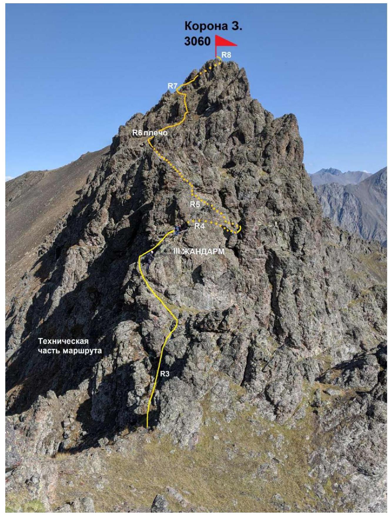
Technical sections of the route (photo 9). Central Caucasus, North Elbrus Region (Jilyasu area), northern spur of Elbrus, Tashlysyrt ridge, peak 3060 (Korona Z.).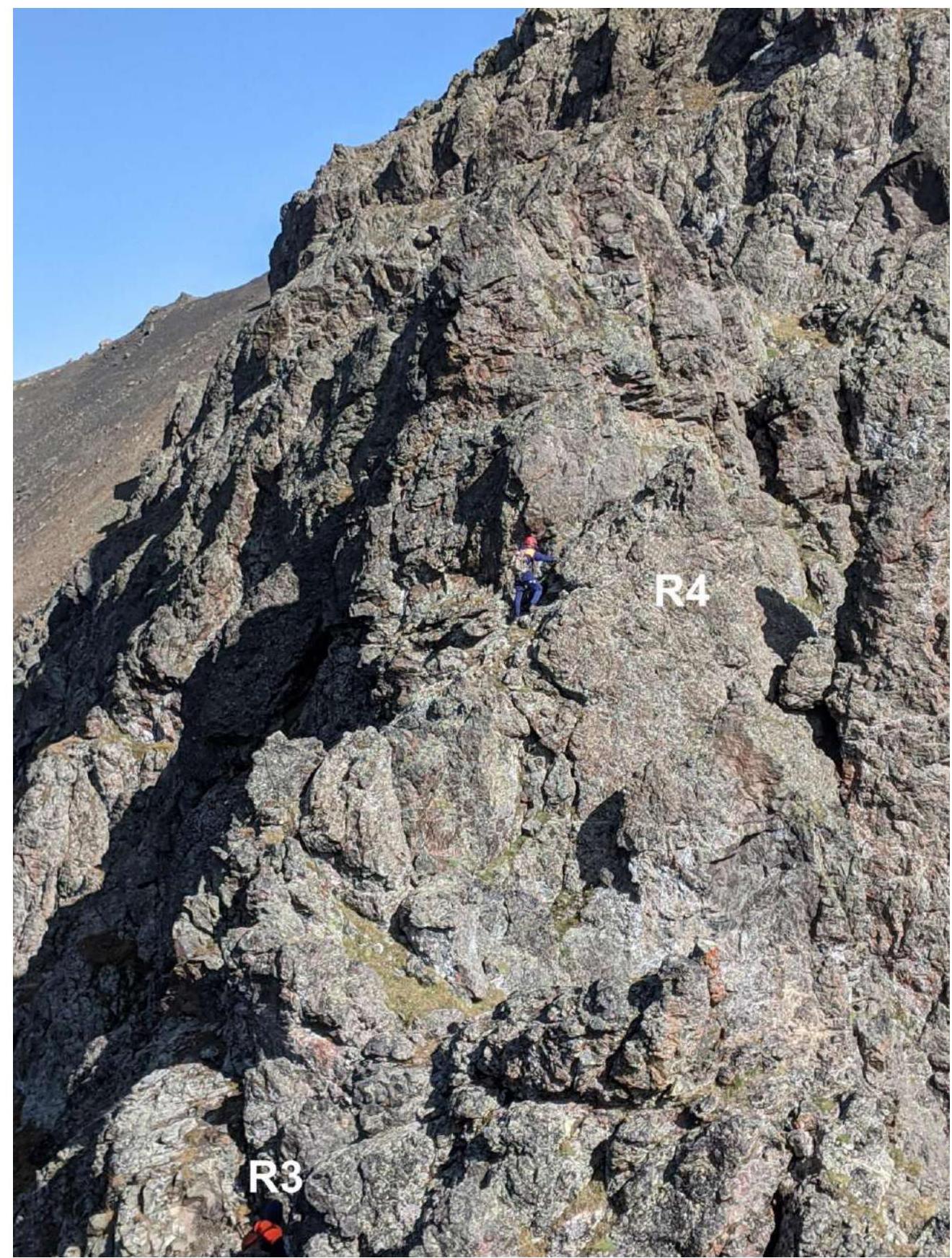
Section R3–R4. Exit to the 3rd gendarme (photo 10)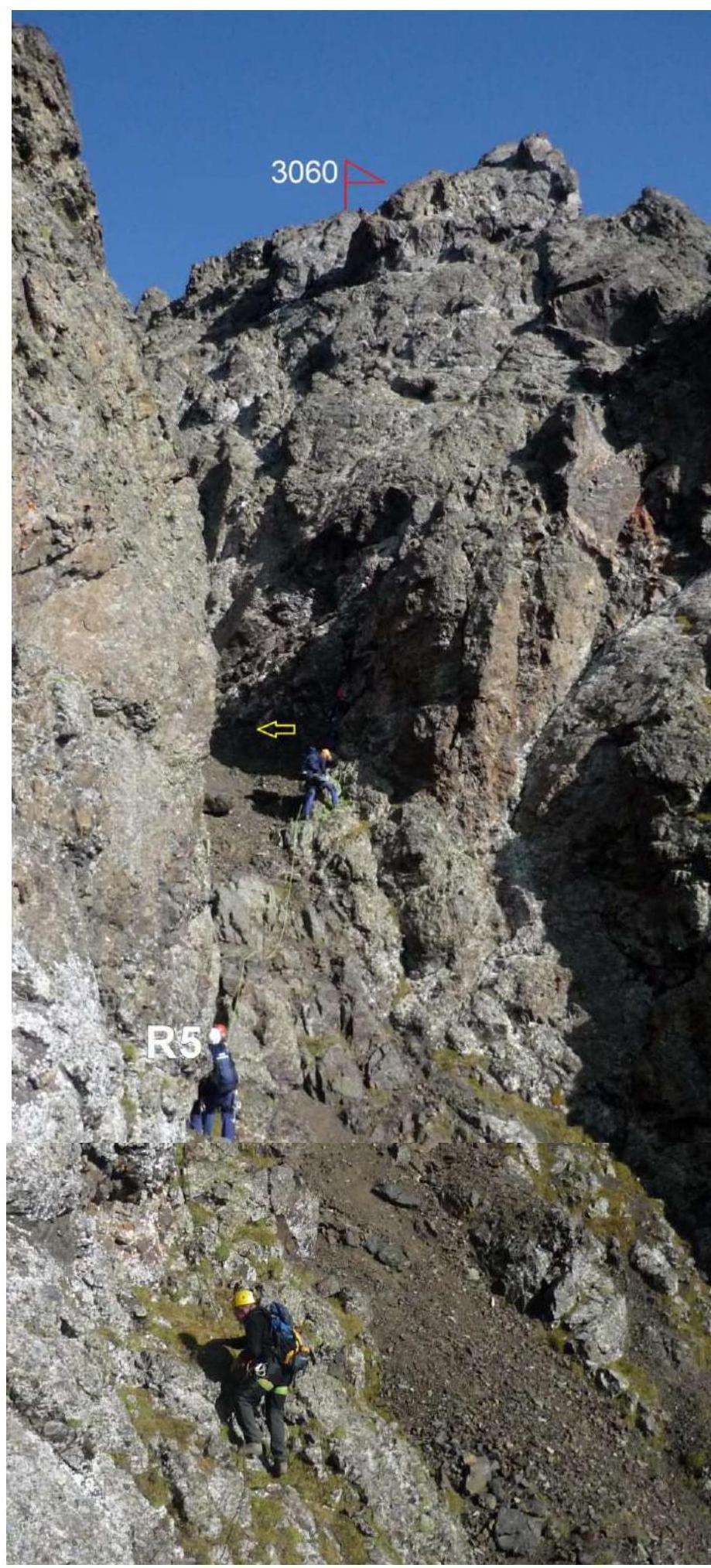
Exit to the key section (photo 11)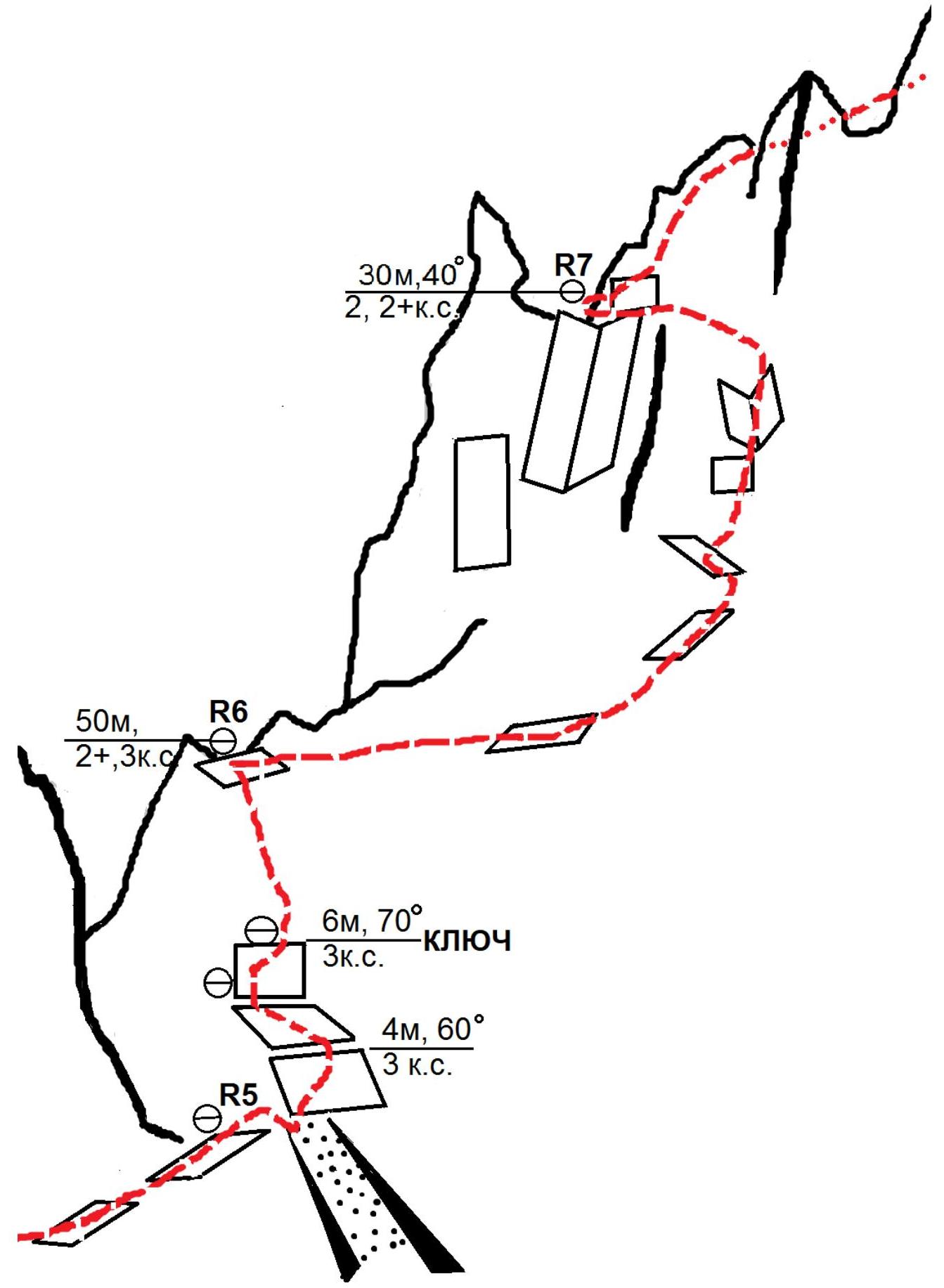
Key section of the route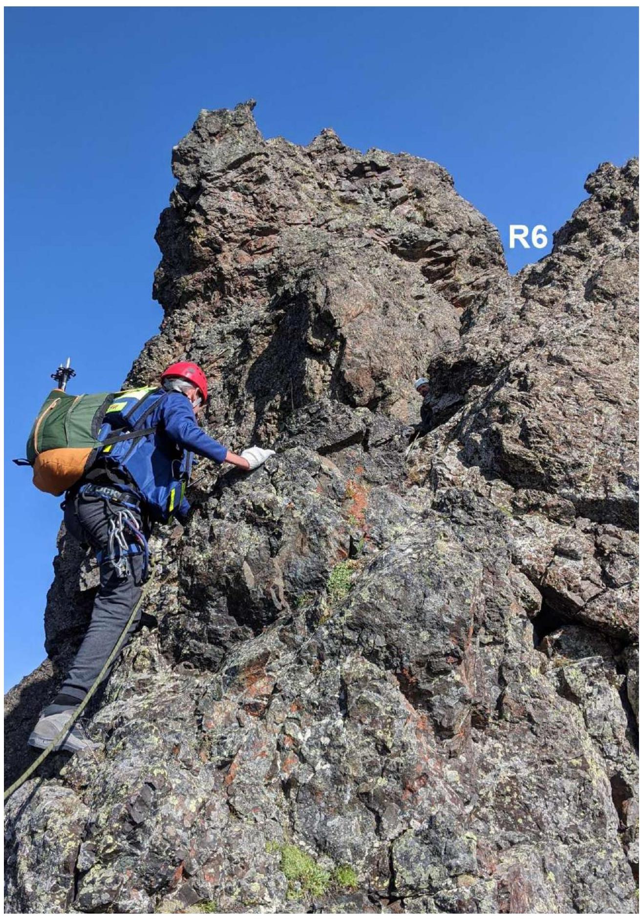
Passing the key section (photo 12)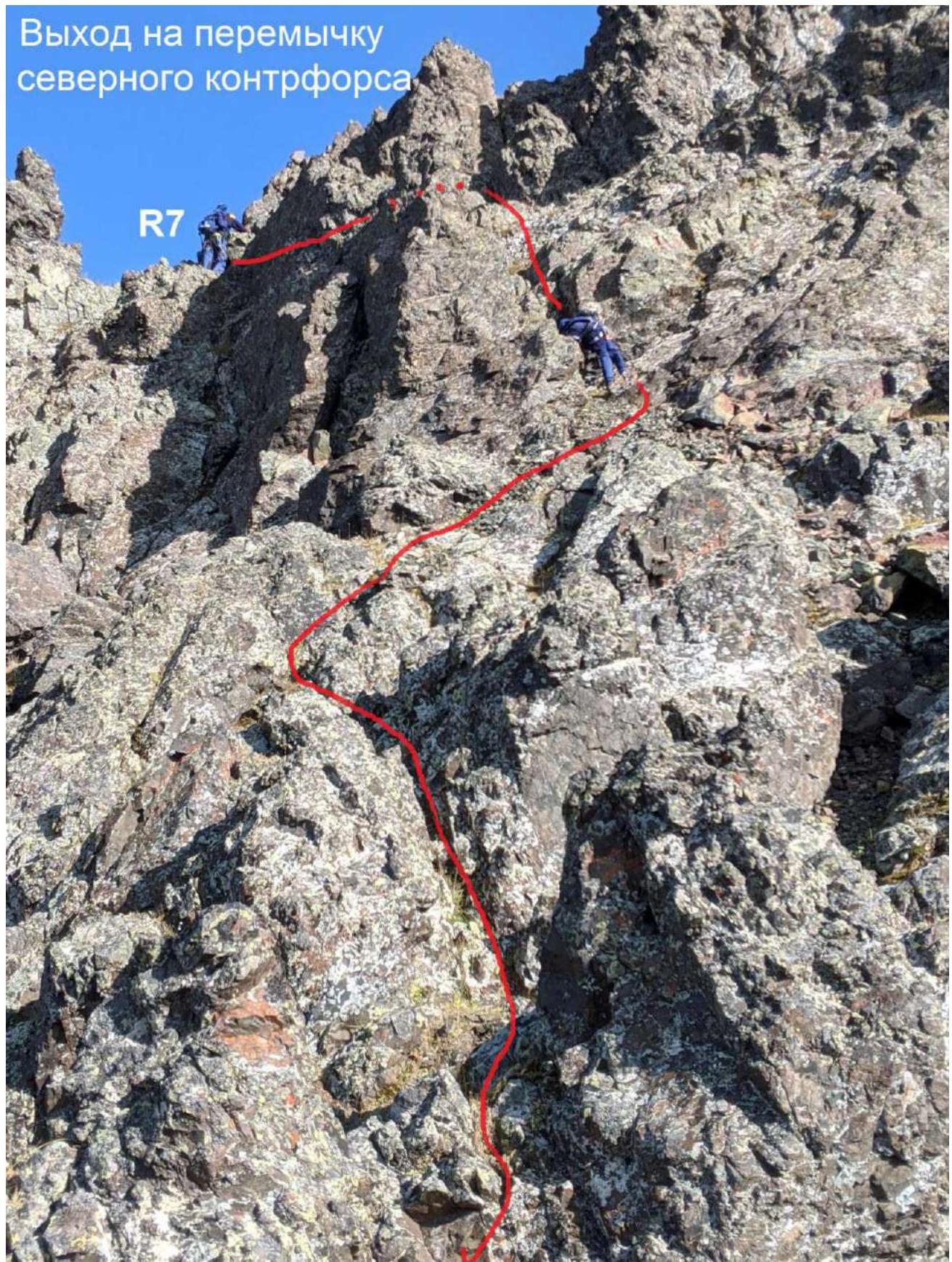
Start of exit from the saddle to the peak, section R7–R8 (photo 14)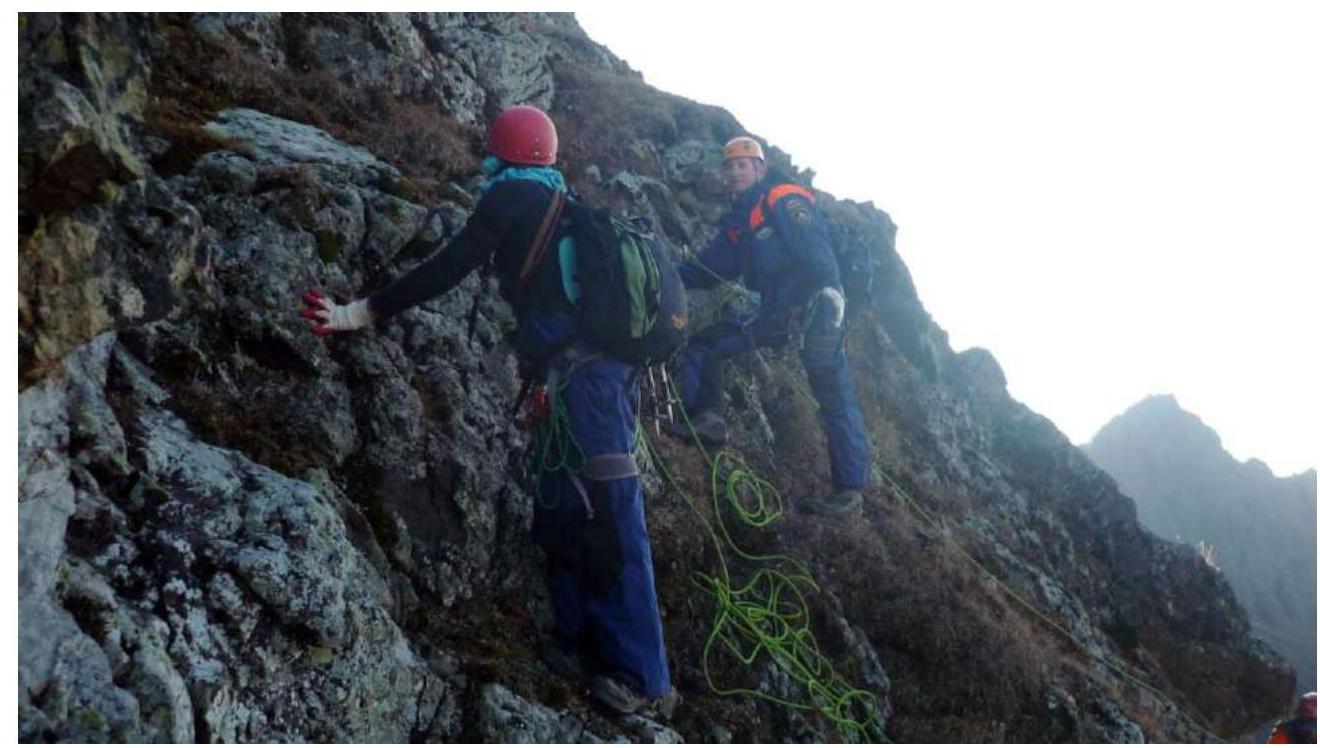
Exit to the peak along the eastern slope, section R7–R8 (photo 15)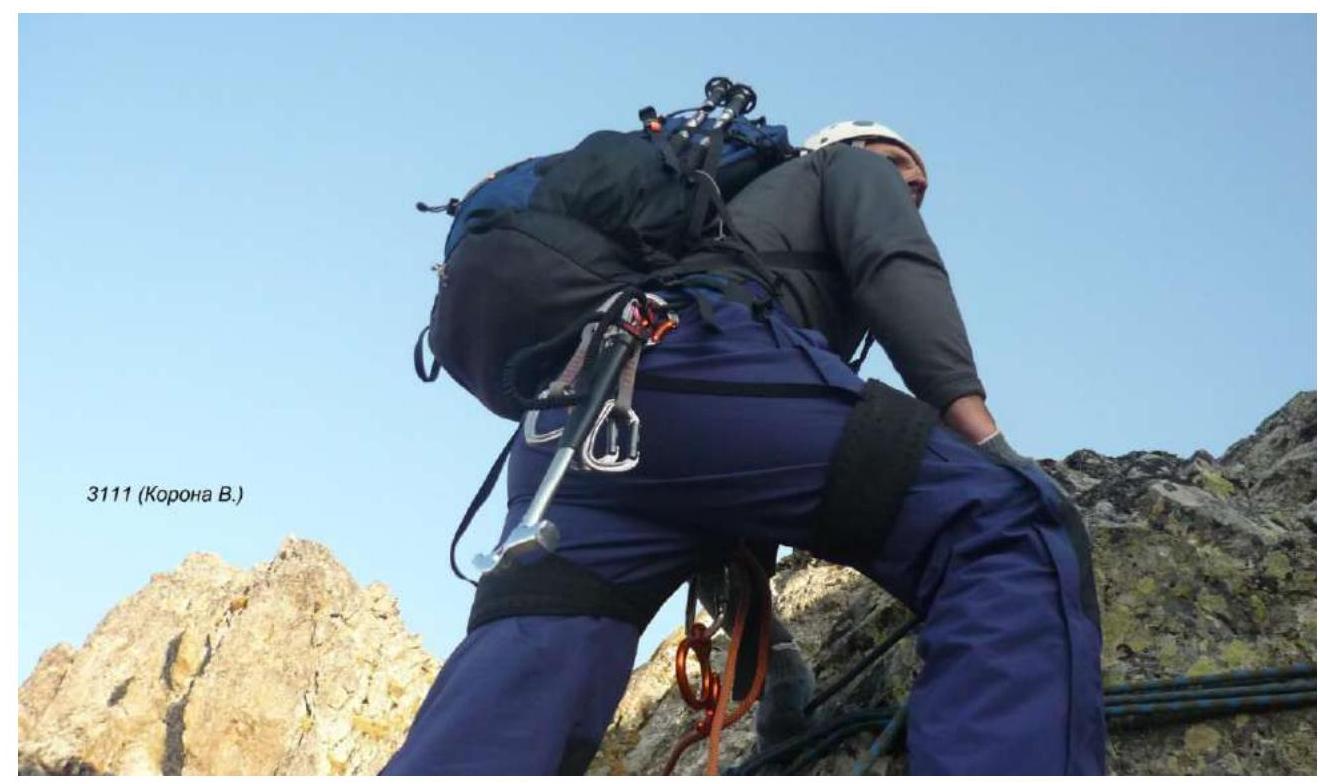
Start of descent from the peak (photo 16)
Descent and traverse of the northern slope (photo 17)
"Dulfer" descent to the northwestern slope (photo 18)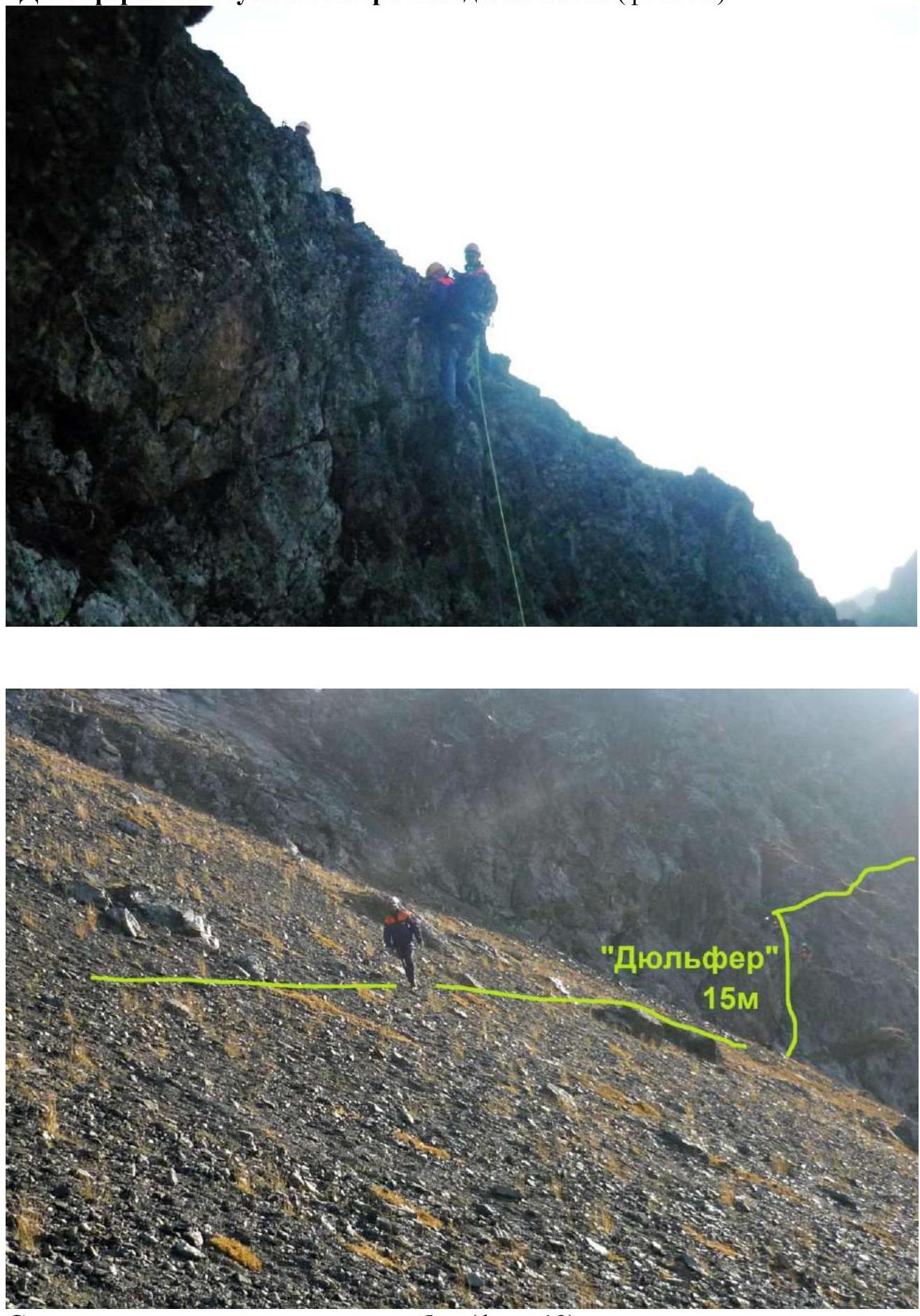
Descent and exit to the saddle of the ridge (photo 19)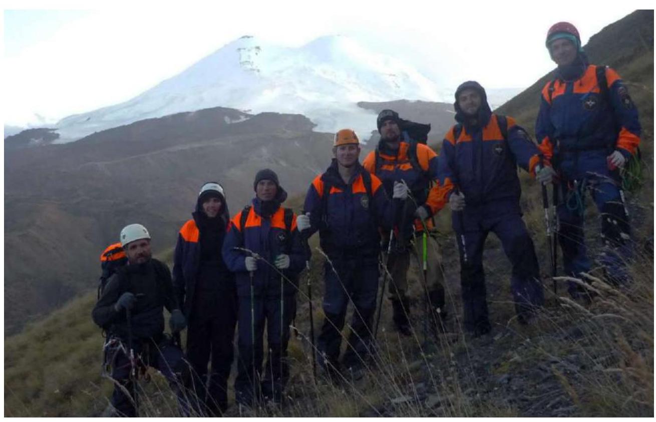
Descent to the valley to the camp (photo 20)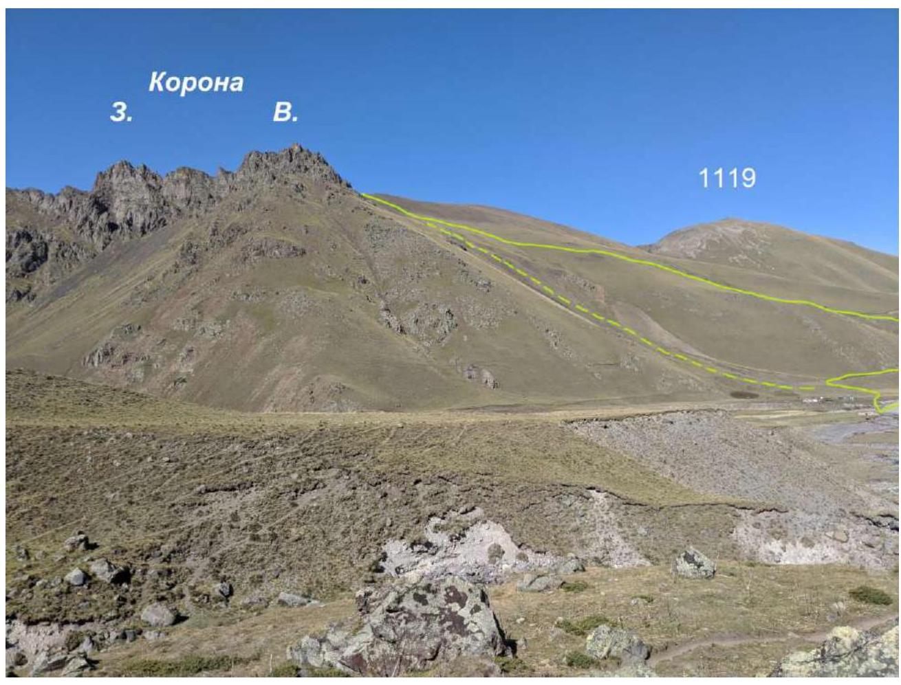
Descent options (photo 21)


